Cite this as: Richards, J.D. 2023 Getting it Together: Combining information about archaeological sites and artefacts in ARIADNE, Internet Archaeology 64. https://doi.org/10.11141/ia.64.14
There has been a recent increase in the number of national systems designed to capture information about finds discovered by members of the public. This is in response to the growth in popularity of metal detecting as a hobby, and the recognition that important information about the past is at risk of going unrecorded. The first such system was the Portable Antiquities Scheme (PAS) Database, managed by the British Museum, founded in 1997 (British Museum 2021). In England metal detecting is entirely legal, so long as it is not undertaken on protected 'Scheduled' sites. Recording is voluntary, unless the items are classed as 'Treasure', which broadly comprises artefacts and coins over 300 years old made of precious metals, or objects found within hoards. In 2023 the definition of Treasure as laid out in the Treasure Act 1996 is due to be extended, whereby exceptional finds over 200 years old – regardless of the type of metal of which they are made - will be classed as Treasure, as long as they provide an important insight into the country's heritage.
The PAS developed a national network of largely county-based Finds Liaison Officers (FLOs) to assist in the voluntary recording of finds and to maintain the database. The scheme has been extraordinarily successful and as of April 2023 the database holds information about more than 1.6 million artefacts and coins. There are now similar schemes in the Netherlands (Kars and Heeren 2018), Denmark (Dobat et al. 2019), Finland (Hyvönen et al. 2021), and the Czech Republic (Padjla et al. 2023), with explorations into setting up equivalent schemes in several other countries. There was also an attempt to set up a scheme in Flanders, although this is no longer being actively developed (Deckers et al. 2016).
In England the PAS is a rich research resource and on their website the PAS lists a total of 916 projects to have used it, including 20 large-scale research council funded projects, 189 PhDs, 225 Masters degrees and 148 undergraduate projects. Nonetheless, it must be borne in mind that given the database largely, but not exclusively, contains information about metal finds, with a focus on non-ferrous items, it is a very selective source. Although widely used in artefact distribution studies, it is also subject to multiple recovery and recording biassing factors, including modern land-use, accessibility, and reporting and recording practices (Robbins 2013a; 2013b). Nonetheless, within the plough zone areas of eastern and southern England artefact distributions are proxies for human activity and, if used critically, such data have the potential to address major research questions, including variations in population densities and the impact of climate and sea-level change. When one takes account of the style and form of artefacts, the geographical spread of specific types can be used to study human migration and technological development.
However, to harness the true potential of this relatively new source of information we need to be able to conduct cross-border searches. Whether we are studying the spread of metallurgy in the Bronze Age, major population movements in the wake of the decline of the Roman Empire, or the reach of Hanseatic trade, the scope of individual national finds databases created in line with 21st-century political boundaries are irrelevant, and we need to look at artefact distributions drawn from multiple systems. In his pioneering work on archaeological cultures Gordon Childe spent a lifetime collating cross-border data by visiting the archaeological museums of many European countries (e.g. Childe 1929). Given the scale of modern archaeological work, such an endeavour would now be impossible unless information technology and the power of GIS mapping are harnessed.
At a micro-level, individual artefacts and clusters of artefacts each have a story to tell. Although they each reflect casual loss, that action represents a specific moment in time and an event in artefact biography. Larger concentrations of finds may reflect a focus of human activity, potentially a hitherto unknown settlement or cemetery location. In England many archaeological periods are almost invisible in terms of surviving stone or timber structures or even earthwork monuments. For example, in lowland England, Viking Age settlements of the 9th to 10th centuries AD were largely invisible before the advent of metal detecting. Now we can see a dense settlement pattern. Dawn Hadley and myself recently published a book entitled The Viking Great Army and the Making of England (Hadley and Richards 2021), which was largely based upon evidence first discovered via metal detecting. In this we identified a number of new sites associated with the Viking Army, which invaded England in AD 865, by using the distinctive artefactual signatures of objects recorded in the PAS. Similarly, by studying the types of dress accessories found, Jane Kershaw (2013) was able to demonstrate the role of women in the Viking settlement. These studies were only possible because of metal-detected finds.
However, the PAS database does not contain information about archaeological fieldwork and known sites; those databases are kept entirely separately. In England, as in most European countries, there are national and regional registers of archaeological sites and monuments. In England the primary record is managed at county level, where it is generally known as a Historic Environment Record (HER). The primary purpose of such databases is for heritage management, as they are the main means of assessing the potential threat to known archaeology during development control and the planning process. However, they also have a valuable secondary usage in addressing archaeological research questions. HERs are now largely digital and contain information about known sites and monuments, normally encompassing both the above-ground built environment and below-ground buried archaeology. They also contain continually updated information derived from archaeological fieldwork, largely compiled from unpublished fieldwork reports – the so-called grey literature. The county HERs for England are aggregated at national level in the Heritage Gateway, managed by Historic England, which allows distributed cross-county searching. But while HERs provide comprehensive information about known sites, their coverage of discoveries of individual artefacts is generally poor. Furthermore, as a result of the separation of information about artefacts and known sites the PAS is rarely, if ever, consulted in the assessment of planning applications. The local government archaeologist Boldrini (2006) highlighted the problem in a study of the problems of using PAS data and HER data together. Similarly, most academic researchers have struggled to use the PAS alongside HER information and grey literature. One of the few exceptions was the University of Oxford's ENGLAID project, which required major ERC funding, over ten researchers and a bespoke database in an effort to combine PAS and HER data in a longitudinal study of the development of the English landscape (Gosden et al. 2021).
In summary, site and artefact data effectively exist in two worlds in English archaeology. Sites are largely investigated by professional paid archaeologists, whose results end up in HERs, while artefacts are largely found by members of the public – amateur hobbyist detectors users – and they are recorded in the PAS database. The digital world mirrors the recording context, and makes it extremely difficult for either heritage managers or researchers to use both sources of information. Yet both sources may reflect the same foci of human activity and the use of both is essential in order to gain a complete understanding. Many archaeological sites of critical importance are known only from the artefact scatters, while many artefact distributions can only be interpreted in the light of the known archaeology of the area.
This situation is not unique to England. While the new Czech scheme is managed by the same organisation that curates site information, other public finds recording schemes sit outside the national state-regulated heritage databases. The Danish DIME database was developed and managed by Aarhus University; the Flemish MEDEA platform was a project of the Vrije Universiteit Brussels, and in Finland FindSampo is managed by Helsinki University. In the Netherlands PAN also began life as a university-led research project, although it may now be taken on by the state heritage body, the Cultural Heritage Agency.
That has all changed with ARIADNE (Aloia et al. 2017; Richards and Niccolucci 2019). As discussed in more detail by Richards (2023; this volume), the ARIADNE infrastructure has brought together a wide variety of archaeological resources in its portal, allowing the cross-search of archaeological data drawn from over forty countries. The portal is underpinned by an RDF triple store and data are mapped to a shared ontology, the AO-Cat, which is a subset of the CIDOC-CRM (Felicetti et al. 2023). The portal allows data discovery via three key parameters: What, When and Where. Interoperability is achieved by (a) using the ISO WGS84 spatial standard for latitude and longitude information; (b) mapping of all national period terms to absolute dates using the PeriodO web service; and (c) mapping of all native subject terms to the Getty Art and Architecture Thesaurus (AAT).
The use of data standards and controlled vocabularies enhances access, by making data from multiple providers comparable. The portal now holds almost one million resources from the PAS database, including both artefacts and coins, an equivalent number of sites and monuments records from the English HERs and national monuments records, made available to ARIADNE by the Archaeology Data Service (ADS), as well as over 70,000 grey literature fieldwork reports from the ADS. This is the first time that all these resources have been brought together in a single search interface, permitting entirely new research questions to be addressed.
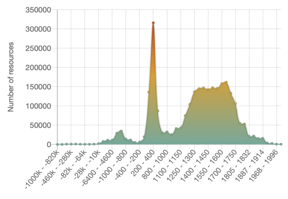
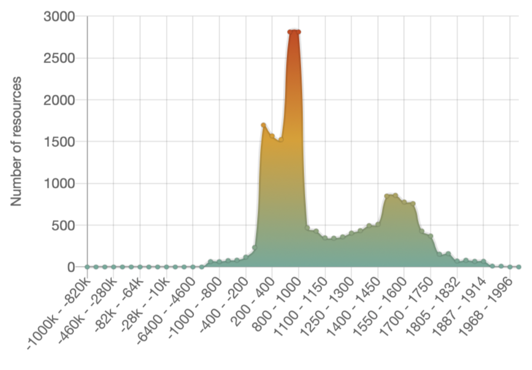
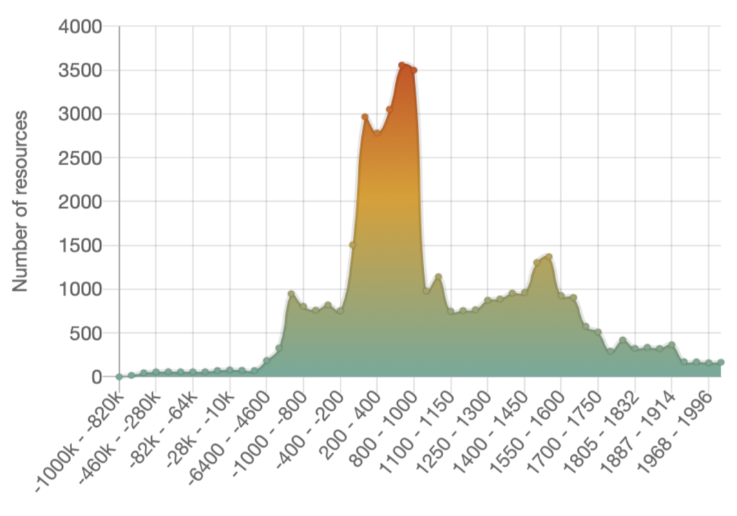
The portal immediately enables 'big data' analyses of the bulk datasets. Comparison of the chronological ranges is immediately striking (Figure 1). Both sources span a broad chronological range, but skewed towards the medieval and post-medieval periods. The PAS graph is distorted by a major peak for AD 0-400, reflecting the large numbers of Roman coins recovered by metal detectorists in England (Figure 1b). The graph is also smoother as many finds have precise chronological ranges, whereas the timeline for sites and monuments is based upon broad period terms derived from the mapping of UK MIDAS period terms to PeriodO.
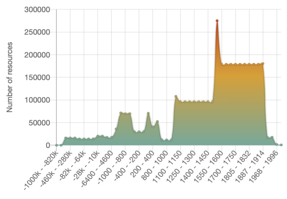
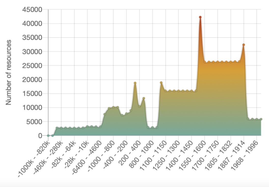
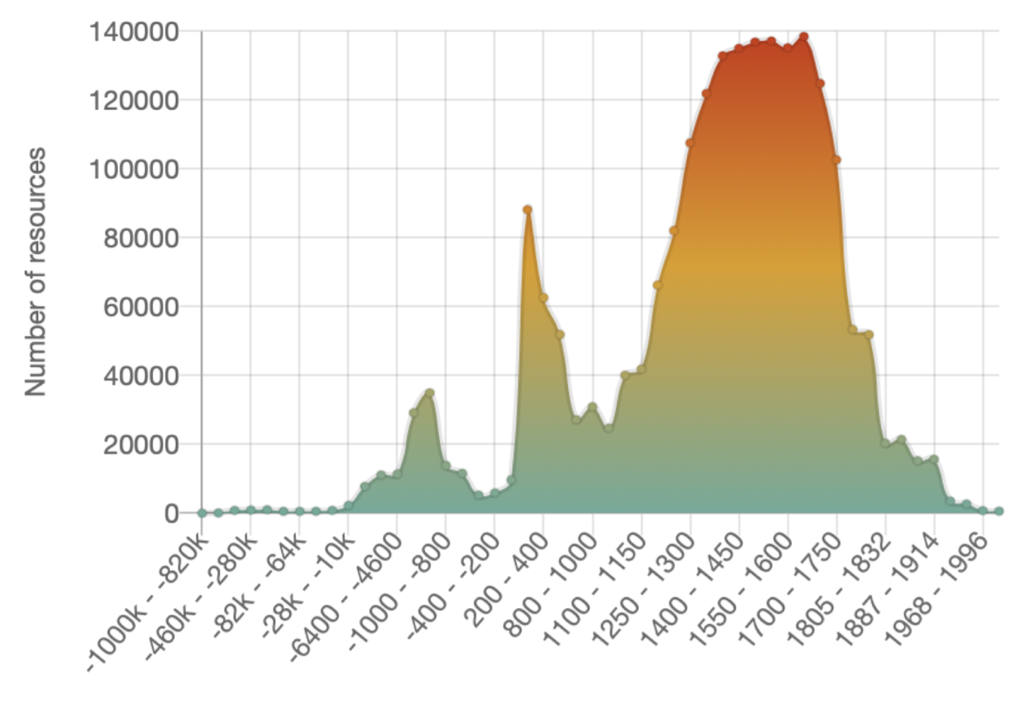
The timeline for fieldwork reports held by ADS reflects the same periodisation and has a very similar profile to that for sites and monuments (Figure 2a), with peaks for the Bronze Age, Iron Age and Roman periods, but with the majority of resources tagged as medieval and post-medieval, as would be expected. If coins are excluded from the PAS timeline (Figure 2b) then artefacts follow a broadly similar trajectory. Clearly such broad trends need cautious interpretation as they reflect recovery and recording practices, as well as differential visibility of the archaeological record in different periods. Nonetheless they highlight the potential for further study and analysis, using the visualisation tools provided in the ARIADNE portal interface.
By applying additional filters much more granular studies become possible. For example, individual Getty AAT categories can be selected, and cross-country comparisons of the chronological range of specific artefact categories are enabled. For example, Figure 3 illustrates the different date ranges assigned to pins in England and Wales (Figure 3a), compared with that from all countries represented in the portal (Figure 3b).
Again, differences may result from different classification schemes being used in different countries, as much as real variations in artefact chronology, but at the very least they highlight the need for international collaboration on artefact classification vocabularies.
Similar comparisons can be made, both nationally, and internationally, looking at artefact distributions. One of the first studies to use the PAS to plot artefact distributions at a national scale was the Viking and Anglo-Saxon Landscape and Economy (VASLE) project, published in Internet Archaeology (Richards et al. 2009). ARIADNE offers the opportunity to revisit that study, and to extend it internationally.
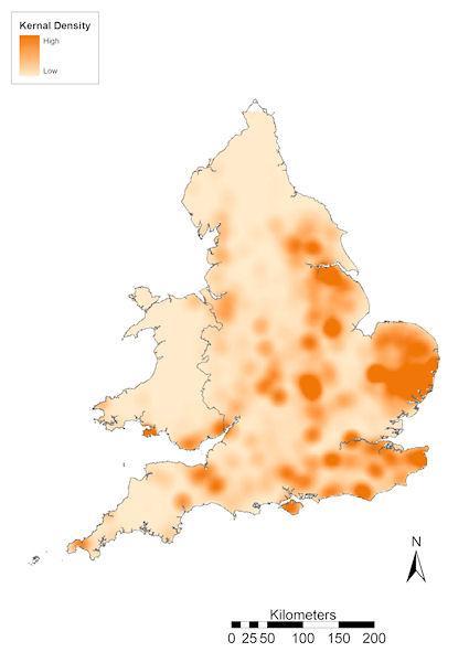
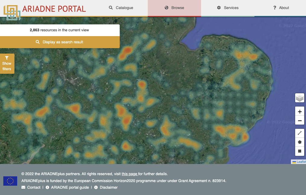
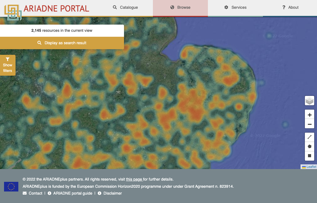
There has clearly been a massive increase in the numbers of finds recorded since 2009 (Figure 4), but if we focus on specific regional and chronological studies there are interesting points of comparison between HER and PAS data. Given that the evidence for Mesolithic activity largely comprises flint microlith tools, the PAS does not include large numbers, as they are not generally collected by metal detectorists. Nonetheless, if the distribution of activity as reflected in HER data is compared with that from the PAS, the distributions are broadly similar (Figure 5). For example, both show a complete absence of activity in the regions bordering the Wash, which was under water until post-medieval drainage and land reclamation. It is also clear that neither distribution represents a complete picture, and both need to be considered in studies of Mesolithic settlement in England.
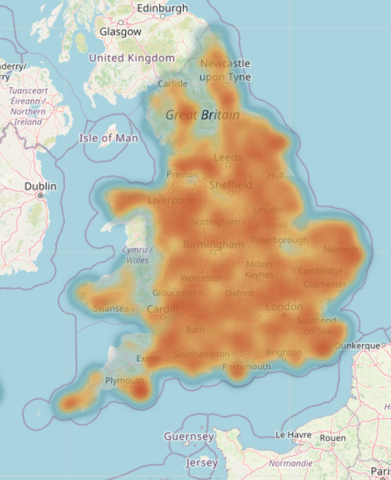
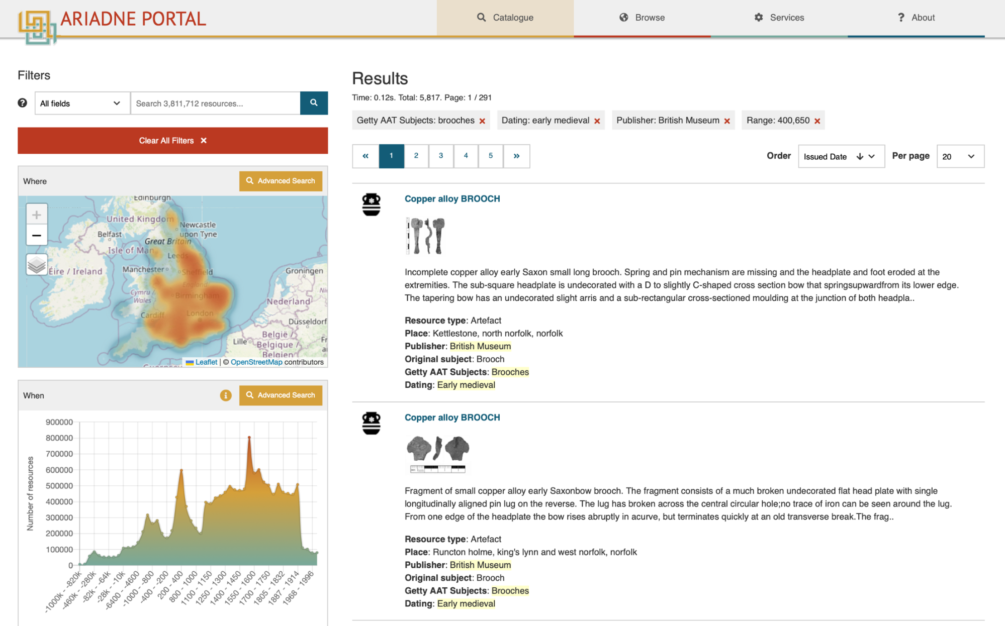
To take a second example, Anglo-Saxon brooches, dated to the period AD c. 400-650, are regular metal-detector finds in lowland Eastern England. These artefacts generally originated as dress accessories buried with the deceased in pre-Christian inhumation graves. Although some may have been removed from graves while cemeteries were still in use, the majority have been disturbed by modern ploughing of hitherto unknown Anglo-Saxon cemeteries. Plotting such artefact clusters can help complete the distribution map of such cemeteries. If we do an overall search for such brooches, in the PAS data made available by ARIADNE then 5817 examples are returned (Figure 6).
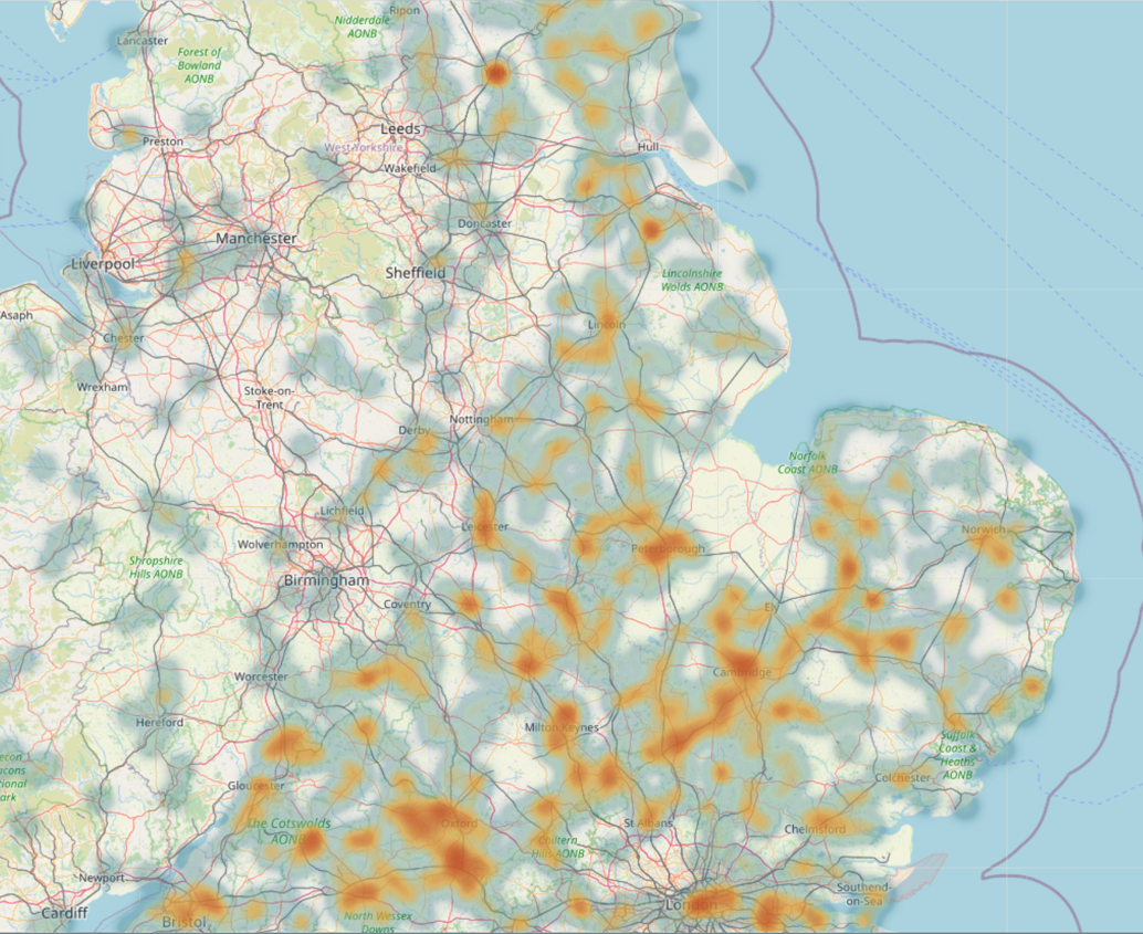
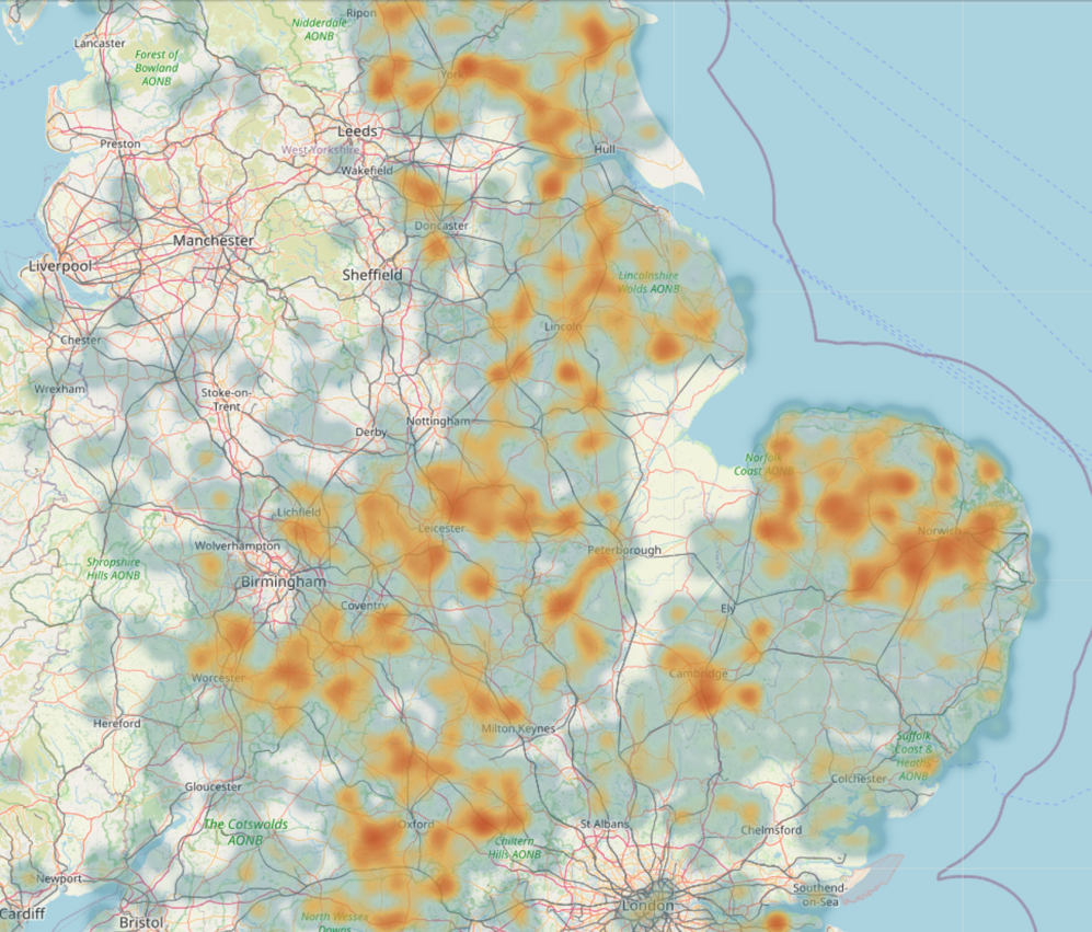
If one compares the distribution of known cemeteries derived from sites and monuments records with the distribution of brooches from the PAS, they are clearly similar but complementary (Figure 7). The PAS distribution is denser but also fills in some gaps in East and North Yorkshire, Lincolnshire, and East Anglia (Figure 7b). There is a notable concentration in Norfolk, which is not so obvious from the sites and monuments information. This partly reflects the high level of metal detecting, and reporting, in those areas of arable agriculture with regular ploughing, but it must also represent density of Anglo-Saxon activity.
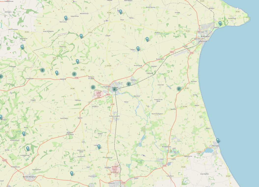
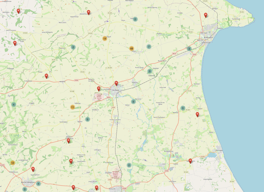
By focusing on a specific area of the East Yorkshire coast, south of Flamborough Head, we can highlight specific areas with concentrations of finds, and sites that might be investigated as potential cemeteries. The maps in Figure 8 are centred on a potential royal Anglo-Saxon vill at Driffield. A number of Anglo-Saxon cemeteries are known to follow the line of the ancient routeway and Roman road that runs from York to the east coast, and passes through Driffield, and there are more in the Wolds hills to the north of the road. However, this is also an area that has been extensively metal detected, and in the area of the Wolds to the south of that road the PAS data reveals several find spots that may represent additional cemeteries. Using only one source would have provided a very skewed idea of Anglo-Saxon settlement densities.
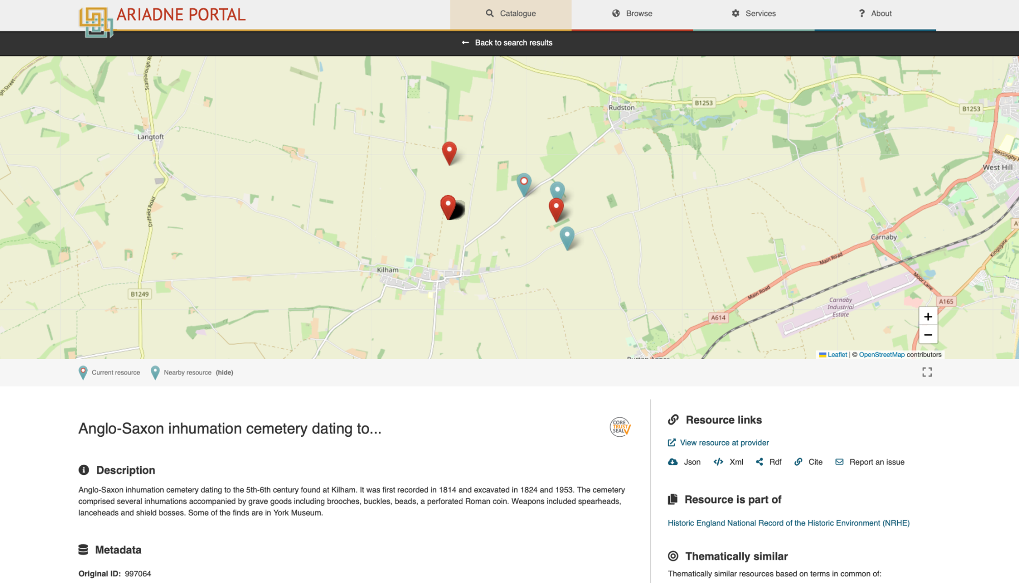
When we go down to the level of an individual site location we can also see potential links between known sites and individual artefact discoveries in the vicinity. For example, Figure 9 shows the Historic England sites and monuments record for the Anglo-Saxon inhumation cemetery dating to the 5th-6th century found at Kilham, East Yorkshire (Figure 9). It was first recorded in 1814 and excavated in 1824, 1953, and more recently. One of the nearby PAS records is for a cast copper-alloy buckle plate from a small Anglo-Saxon buckle (YORYM-CC0BF7). It seems likely that the buckle may be linked to the cemetery. There is no such thing as a random find; all records in the PAS reflect an individual human action in the past, and have a story to tell.
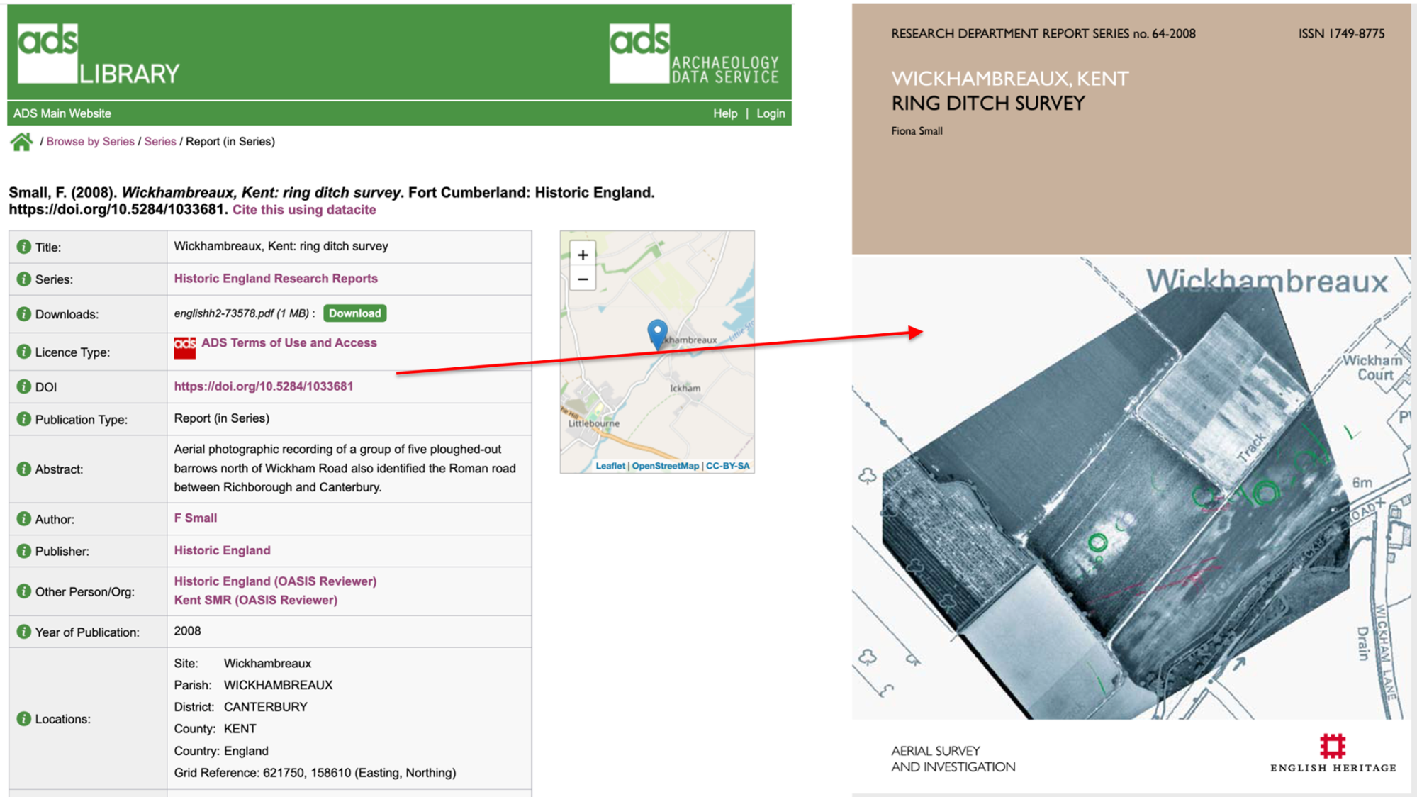
Finally, by connecting PAS data with other sources of information the ARIADNE portal provides an invaluable research tool to allow users to explore connections for themselves. To take another example, this time from Kent, adjacent to the find spot of a copper-alloy brooch, probably disturbed from an Anglo-Saxon female grave, we can see the location of known ring ditches, probably associated with ploughed-out burial mounds.

In a single click from the metadata record in the ARIADNE portal the user can download the grey literature report of geophysical survey undertaken by Historic England, made available online by ADS. The report does not refer to the discovery of Anglo-Saxon grave goods nearby, but a connection is probable.
In conclusion, this article has sought to demonstrate how the ARIADNE portal makes it possible to address new research questions, allowing researchers to investigate how clusters of artefacts discovered by members of the public may relate to known archaeological sites or, in other cases, where they may indicate the presence of hitherto undiscovered sites. To use the portal for research it is critical to consider recovery and recording biases in our sources, and to be aware of the history of archaeological recording, but the portal also allows us to explore these issues on a large scale. It enables us to aggregate information that crosses modern political boundaries, advancing artefact research at a European level. Finally, the integrated search provided by the ARIADNE portal reinforces the importance of Citizen Science in contributing to new knowledge, particularly when this information can be placed alongside existing knowledge created by professional archaeologists.
Internet Archaeology is an open access journal based in the Department of Archaeology, University of York. Except where otherwise noted, content from this work may be used under the terms of the Creative Commons Attribution 3.0 (CC BY) Unported licence, which permits unrestricted use, distribution, and reproduction in any medium, provided that attribution to the author(s), the title of the work, the Internet Archaeology journal and the relevant URL/DOI are given.
Terms and Conditions | Legal Statements | Privacy Policy | Cookies Policy | Citing Internet Archaeology
Internet Archaeology content is preserved for the long term with the Archaeology Data Service (ROR). Help sustain and support open access publication by donating to our Open Access Archaeology Fund.
 Home
Home