Cite this as: Șandric, B., Streinu, M. and Matei, D. 2023 Preparing the Romanian National Archaeological Datasets for ARIADNE, Internet Archaeology 64. https://doi.org/10.11141/ia.64.4
The National Institute of Heritage (NIH) became a partner in the ARIADNEplus project with two main objectives: the valorization of Romanian archaeological heritage through data sharing with the international scientific community and the improvement of the content of the National Archaeological Repertory database through distinct research and documentation activities. NIH's contribution to the ARIADNEplus catalogue was based on the data provided by two national repositories, managed by NIH: the National Archaeological Repertory and the Chronicle of Archaeological Research.
In Romania, the protection and regulation of archaeological heritage research is done through three national laws: Law no. 150 of 24 July 1997 regarding the ratification of the European Convention for the protection of the archaeological heritage, adopted in La Valletta on 16 January 1992; Emergency ordinance 43 of 2000, regarding the protection of the archaeological heritage and the declaration of some archaeological sites as areas of national interest, and Law no. 422 of 2001 on the protection of historical monuments. All these pieces of legislation establish the obligation to keep a rigorous record of all archaeological forms and structures, including destroyed sites. Ordinance 43/2000 establishes for the first time the National Archaeological Repertory as the main instrument to record the archaeological heritage. It must include 'scientific, cartographic, topographical data, images, plans, as well as any other information regarding:
Also, the same law defines archaeological heritage as: 'the ensemble of archaeological assets that consists of:
These two provisions, which are mostly based on the Valletta Convention, define the National Archaeological Repertory (RAN) as a repository of all traces, goods and human structures that can be attested archaeologically, to which, in theory, a fairly rigorous protection regime applies. The purpose of this protection is not that of indefinite preservation but to establish an obligation of research in case of partial damage or destruction by infrastructure or real estate projects, and also to stop thefts and interventions by non-specialists.
Law 422/2001 establishes the rules by which the List of Historical Monuments is created, which is divided into four categories according to their particular nature:
Inclusion in the List of Historical Monuments requires a historical study that must demonstrate the special value (national or universal) of an immovable cultural asset. Subsequently, the Ministry of Culture accepts or rejects the proposal for listing as a historical monument. Historical monuments are protected from destruction and all changes to them must be approved by the Historical Monuments Commission and by the Ministry of Culture. As a result, only some of the archaeological sites registered in the National Archaeological Repertory are also found in the List of Monuments, more precisely about 10,000 out of a total of 30,154 (https://patrimoniu.ro/ro//articles/lista-monumentelor-istorice). To sum up, Law 422/2001 imposes a much stricter protection regime on archaeological sites listed as historical monuments, which can only be researched and restored with the approval of the Ministry of Culture. In comparison, sites that are not listed but figure in the RAN can be exhaustively researched and they cannot be included in restoration projects funded from public resources.
In the text of the 2000 Law, two administrators are established for the National Archaeological Repertory: the Ministry of Culture, which also holds the rights of use; and the Institute of Cultural Memory-CIMEC, which in 2010 was merged with the National Heritage Institute, which took over its duties. The law was followed by the Order of the Ministry of Culture no. 2458 of 21 October 2004, establishing the regulation of the administration of the NAR, establishing the mission, as well as the structure and management of this repository:
'The National Archaeological Repertory is a method of scientific management that allows the realisation of a general inventory and the geographical and cartographic visualisation of the information collected for the purpose of managing, protecting and enhancing the value of the archaeological heritage.
The purpose of the National Archaeological Repertory is to locate and assess as precisely as possible the known archaeological heritage, to assess the areas where the heritage is threatened by risk factors and to identify new archaeological sites.
The National Archaeological Repertory includes scientific, cartographic, topographical data, images and plans, as well as any other information regarding the archaeological heritage, regardless of the source of research funding.' (Order of the Ministry of Culture and Religions no. 2458 of 21.10.2004, article 5 and 6).
Order 2458 also establishes the sources and formats of the data that must be fed into the RAN, but does not impose the obligation to transmit these resources to the Institute of Cultural Memory, which undertakes the documentation activity. In fact, the Ministry of Culture has never had a systematic method for gathering data from the institutions organising archaeological research or even transmitting the data it receives to the National Institute of Heritage in order to update and correct the content of the RAN.
As a result, the RAN lacks a systematic tool for collecting and centralising data, which seriously affects the procedure for updating and registering new archaeological sites. The order of the Ministry of Culture from 2010 regulating the procedure for granting archaeological research authorisations was only modified in November 2022, by adding a provision that requires the institutions organising archaeological research to send the research reports to the NIH to update the RAN (Order of the Ministry of Culture and National Heritage no. 2562 of 2010, article 18, 1). Subsequently, the NIH specialists and the Ministry of Culture will also establish a transmission procedure in the near future.
Together, the Law of 2000 and the Order of 2004 created a double status of the RAN, both in administrative and scientific terms, which should have ensured a two-fold perception among professionals: as a protection tool and as a scientific resource (Șandric 2016, 283-84). The Institute of Cultural Memory was in fact the institution that organised and laid the foundations of the RAN, both as a database and as a tool for recording the archaeological heritage. Its goals were set in 2001 and have remained the same to this day:
The main documentation sources for the National Archaeological Repertory are represented by:
The RAN data model was developed by a working group formed by representatives from CIMEC and, since 2001, the 'Vasile Pârvan' Institute of Archaeology (Oberländer-Târnoveanu and Matei 2009 102; Oberländer-Târnoveanu 2014, 22). The RAN database became accessible online through a public interface in 2007.
The structure of the database is divided into four general units (tables), which describe archaeological realities and which are subordinate to each other:
The structure of the database is divided into four general units (tables), which describe archaeological realities and which are subordinate to each other:
Two more tables were added to record bibliographic information about archaeological fieldwork. The field lists in each table were drawn up on the basis of the minimum data standard for archaeological sites and monuments developed under the auspices of the Council of Europe (1993–1995) by the Working Group on Archaeological Sites of the International Documentation Committee of the International Council of Museums (CIDOC/ICOM) (Oberländer-Târnoveanu and Matei 2009, 103; Oberländer-Târnoveanu 2014 26), as well as a series of specifications of national databases to record archaeological sites and monuments used in Denmark (Det kulturhistoriske Centralregister - DKC), France (DRACAR, which since 2002 has been replaced by PATRIARCHE according to Cottenceau and Hannois 2002, 53-60), Great Britain (MONARCH Heritage Database Management System) and the Netherlands (ARCHIS) (Oberländer-Târnoveanu and Matei 2009, 103).
The SITE table includes an identifier (site code), the administrative and geographic location (locality, higher administrative unit, county, toponym, landmark, geographic coordinates, etc.), the type and category of the site, as well as other information related to ancient names of the sites, to the regime of ownership and owners. Later, other fields were added to record the state of conservation and the assessment of natural and anthropogenic risks, in accordance with the analytical form for the inventory of archaeological sites (from the Methodological Norm of 04/18/2008 for the classification and inventory of historical monuments, approved by the Order of the Ministry of Culture no. 2260 of 18/04/2008).
In order to standardise, site localities are obtained from the Information System of the Register of Territorial-Administrative Units (SIRUTA), an administrative repository created by the National Institute of Statistics. The register is correlated with the NTSU/NUTS (Nomenclature of Territorial Statistical Units) coding used in the European Union. The ASSEMBLY table allows information to be recorded about the typological and functional classification, dating and cultural attribution, respectively the location of such an archaeological entity within a site (Șandric 2016, 291).
The COMPLEX table includes the typological and functional classification, the location within an ensemble or a site, as well as the relative and absolute dating of the discoveries. The OBJECT table refers to the typological, chronological, functional and cultural classification of objects from an archaeological site, complex and/or an ensemble. For other details see Streinu and Șandric 2023.
The Chronicle of Archaeological Research is a data repository created and managed by the Cultural Memory Institute-CIMEC since 1994 and it has been accessible online since 1999 (Oberländer-Târnoveanu 2014, 29). Its origin can also be found in the Emergency Ordinance 43 of 2000 (article 12, n.), which states that it must be managed by the National Archaeology Commission. Since 2010, following the merger of CIMEC with NIH, the Chronicle of Archaeological Research has been developed by the latter institution.
The purpose of this database is to record the preliminary reports of systematic and preventive archaeological research. At the same time it is a main source of data for updating the RAN. Developed like the RAN using a Microsoft Access solution, the source of information for the Chronicle of Archaeological Research was the annual printed publication of a volume of the same name by the National Commission of Archaeology under the Ministry of Culture, in partnership with NIH or other institutions. Sometimes the database contains reports that were sent after the deadline and therefore not published, but NIH decided to register them so that they are disseminated at least in this form. At other times various errors in the printed volume have been removed from the database.
Unfortunately, although a set of publication guidelines was created by CIMEC in 1999 to regulate the structure of a report and to add the obligation to produce a summary in an international language, these rules are not always respected by authors. As a result, the reports are very different, some being excessively long while others are incomplete, sometimes without images or spatial data. Information from the Chronicle of Archaeological Research database is a primary source for updating the content of the RAN. The two databases are interconnected by the identification numbers of the archaeological sites in the RAN.
In order to fulfil the NIH's obligations within ARIADNEplus, several corrections and changes were made to the structures of the two repositories (RAN and Chronicle) as well as data updates.
Following an analysis carried out by the RAN team three main priorities were identified:
Also, a fourth priority was taken into account: the completion of the bibliographic list and the record of archaeological research campaigns for important archaeological sites. Later, a fifth priority was added, which unfortunately could not be finished until the end of the project: the creation of a thesaurus of chronological periods and eras used in Romanian archaeology.
In the RAN, the only collections of images that were exhibited were taken automatically from the Chronicle of Archaeological Research database. As a result, very few archaeological sites in the RAN were also described by photographs. Consequently, the creation of a photo upload module that illustrates both an archaeological site perceived as a landscape and its various components, has become a necessity. In order to create this module, initially the metadata scheme to describe a photo was designed. A balance between quantity and quality was taken into account and a minimal scheme was chosen mainly to record the source, creator and date of the image. Also, for the photos already published online, the possibility of registering the link has been created.
A particular problem was the selection of photographs to be associated with an archaeological site. For a rigorous selection, a minimal set of rules was established that prioritised panoramic photographs and topographical plans over those illustrating particular details. The quality and size of the images was also a selection criterion, with the largest ones prioritised. The most common sources for providing the images were the most recent studies and the NIH archive. Occasionally images from older literature or images created by the RAN team via aerial flights were used. As a result, the number of photos illustrating archaeological sites increased between 2019 and 2022 from about 50,000 to over 100,000 for a total of 5000 archaeological sites.
One of the great needs of the RAN was the accurate spatial location of archaeological sites. Ordinance 43/2000, as well as Order no. 2458/2004 considered the cartographic component of the RAN as essential in the process of recording the archaeological heritage (Emergency ordinance 43/2000, article 17, 4; Order of the Ministry of Culture and Religions no. 2458 of 21.10.2004, article 2, 4, 7).
The biggest problem when making a spatial and topographical distribution map of the archaeological sites in the RAN was the absence of a location expressed as accurately as possible by geographical coordinates. Even the descriptive landmarks that were registered in the RAN could not be used because they were ambiguous or very general, and the toponyms were only rarely found on the topographic maps that we had access to. The maps from the county registries published until 2005 were, with few exceptions, general sketches of a region, in which the sites could hardly be located. Moreover, even in situations where the maps were made on a more detailed scale, the location of the sites was uncertain, not being supported by topometric measurements and often not even by systematic field research. A special campaign to locate sites would have been impossible owing to the lack of financial, technical and logistical means; hence, we chose as a compromise solution to place the archaeological sites in the centre of the nearest locality, using the SIRUTA code from the list of localities.
The beginning of the ARIADNEplus project coincided with a staff recruitment campaign in order to develop the RAN, and as a result we started the campaign to locate and spatially delimit those sites already registered with a much greater accuracy than in the previous period. In order to achieve a maximum yield, a strategy based on several objectives was established: obtaining an advanced knowledge of the principles of geographic information systems by team members, identifying the most credible sources and establishing a set of rules for the analysis and comparison of the sources. Consequently, in just a few months the number of geo-mapped sites began to increase substantially.
Thus, between 2018 and 2022, the number of sites represented by geographic coordinates in the RAN increased from c. 6000, out of a total of approximately 17,000 sites, to 16,000 out of a total of 24,000. Unfortunately, a rather large difference between geo-located sites and those without an exact known location still exists. Most of the unmapped sites were surveyed by short-term campaigns between 1950 and 1990, and they were published without location maps.
In fact, it was only in 2000 that topographic maps with scales up to 500,000 were declassified and could be procured and used in civilian activities without the obligation to obtain a special use permit. All spatial data were stored in a table of the RAN database using geographic coordinates in the World Geodetic System, although the official cartographic projection of Romania is Stereographic 1970. We opted to use this standard because it is the most frequent in the online display of spatial data. It is the system also used by Google maps applications, whose maps are used as backgrounds in many GIS web projects. The validation and correction of the spatial location of the archaeological sites was done mainly via two methods: either by comparing the geographical coordinates of a location with the textual description of the location in the same bibliographic resource (e.g. text referring to certain geographical or administrative landmarks) or by superimposing the geographical coordinates of a location from a bibliographic resource on other cartographic resources, such as topographical maps or satellite images. The most commonly used sources were the studies for the general urban plans and the topographical map of Romania at a scale of 1:25000, made in three editions between 1960 and 1990. In parallel, we started an intense dialogue with archaeologists from the museums and the County Directorates of Culture in order to prepare files of sites, including those sites already registered in the RAN, with the aim of obtaining as accurate a location as possible.
The third priority of the RAN update campaign was to create a hierarchical thesaurus of terms that describe the types and morphology of an archaeological site and its components. Until that moment, the types of archaeological sites were identified by two lists of terms in a hierarchical relationship: category, which was the general list (e.g. habitation, burial discovery, communication routes) and type, the specific list (e.g. settlement, necropolis, road). Since both lists were not closed controlled vocabularies, quite a few mistakes had accumulated over time, such as using different terms for the same type of sites. As a result, within the RAN team the decision was made to create a hierarchical thesaurus, as a closed controlled vocabulary, to which the third list is added, respectively the types that describe the main components of a site (e.g. fortified settlement, tumular necropolis, dirt road). After establishing the list of terms and implementing them in the database, we moved on to the stage of correcting and replacing the old terms from the RAN with those from the database.
Unfortunately, following the mapping to ARIADNE (AO Cat Ontology), not all the elements from the RAN scheme could be retrieved, including information on the risks and threats, the conservation status and the description of the components of an archaeological site. Another problem that arose after the import into the ARIADNEplus catalogue was caused by the fact it is mandatory in AO Cat to register the loaded resources to an archaeological time period. In the RAN there are several sites that do not have a specific chronology because the author did not propose a firm dating. As a result, in order to meet the AO Cat requirement and being pressed for time we have taken the decision to drop these records, to be corrected by a special identification project.
In order to include the RAN records in the ARIADNE Knowledge Base, the first step was to really understand the AO-Cat. For that, a program was produced to describe the AO-Cat in a hierarchical view (from its rdf format) (Table 1).
| aocat:AO_Data_Resource | |||
| > aocat:has_access_policy [> xsd:anyUri] | |||
| > aocat:has_access_rights [> xsd:string] | |||
| > aocat:has_extent [> xsd:string] | |||
| > aocat:has_landing_page [> xsd:anyUri] | |||
| > aocat:was_created_on [> xsd:dateTime] | |||
| > aocat:has_original_id [> xsd:string] | |||
| > aocat:has_ARIADNE_subject [> aocat:AO_Concept > aocat:is_ARIADNE_subject_of ^] | |||
| > aocat:has_derived_subject [> aocat:AO_Concept > aocat:is_derived_subject_of ^] | |||
| > aocat:has_language [> aocat:AO_Concept > aocat:is_language_of ^] | |||
| > aocat:has_native_subject [> aocat:AO_Concept > aocat:is_native_subject_of ^] | |||
| > aocat:has_spatial_coverage [> aocat:AO_Spatial_Region > aocat:is_spatial_coverage_of ^] | |||
| > aocat:has_spatial_precision [> aocat:AO_Dimension > aocat:is_spatial_precision_of ^] | |||
| > aocat:has_temporal_coverage [> aocat:AO_Temporal_Region > aocat:is_temporal_coverage_of ^] | |||
| > aocat:is_about [> aocat:AO_Entity > aocat:is_subject_of ^] | |||
| > aocat:refers_to [> aocat:AO_Entity > aocat:is_referenced_by ^] | |||
| – | aocat:AO_Collection | ||
| > aocat:has_part [> aocat:AO_Data_Resource > aocat:is_part_of ^] | |||
| – | aocat:AO_Individual_Data_Resource | ||
| – | – | aocat:AO_Digital_Image | |
| > aocat:is_mirror_of [> xsd:anyUri] | |||
| – | – | aocat:AO_Document | |
Then we moved directly to the aggregation procedure and provided our data in the AO-Cat compliant RDF format. But the ARIADNEplus aggregation team identified that some conventions (e.g. usage of the vocabularies, the ARIADNE categories for internal organisation) are difficult to retrieve directly. Thus, we agreed to convert the records from our RAN relational database to an intermediate XML format that is directly usable by the 3M tool (developed by the aggregator) to map the source archaeological records to the internal format of the ARIADNE Knowledge Base.
Thus, we devised an XML schema for this intermediate format and a program to convert our data to it (Table 2).
|
To get this format in an acceptable form for the 3M tool, much discussion with the aggregation team was required. They suggested many subtle adjustments, including the best ways to use the vocabularies associated with the AO-Cat. These suggestions were a lot of help, especially for the procedure to align our descriptors to the Getty AAT (Art and Architecture Thesaurus) and to the PeriodO vocabulary of the historical periods.
Finally, our data, in this new format, were successfully incorporated in the ARIADNE Knowledge Base. To meet the requirements of AO-Cat we needed to extract a number of subject terms from the RAN database and align them with the Getty AAT. Taking into account AO-Cat and the priorities of the RAN team, we decided that the most appropriate terms are those in the two hierarchical lists describing site types. In the end, about 5000 terms were aligned to the Getty AAT (Table 3).
| sourceTerm | sourceField | GettyUrl | GettyLabel |
|---|---|---|---|
| așezare | S_Categorie_sit | http://vocab.getty.edu/aat/300008347 | inhabited places |
| așezare | S_Tip_sit | http://vocab.getty.edu/aat/300008347 | inhabited places |
| așezare fortificată | S_Tip_sit | http://vocab.getty.edu/aat/300387238 | fortified settlements |
| așezare militară | S_Categorie_sit | http://vocab.getty.edu/aat/300387275 | military centers |
| așezare urbană | S_Tip_sit | http://vocab.getty.edu/aat/300130893 | urban areas |
| Așezare urbană fortificată | S_Tip_sit | http://vocab.getty.edu/aat/300130893 | urban areas |
| amfiteatru | S_Tip_sit | http://vocab.getty.edu/aat/300007128 | amphitheaters (built works) |
| apeduct | S_Categorie_sit | http://vocab.getty.edu/aat/300006165 | aqueducts |
| apeduct | S_Tip_sit | http://vocab.getty.edu/aat/300006165 | aqueducts |
| apeduct şi necropolă | S_Tip_sit | http://vocab.getty.edu/aat/300006165 | aqueducts |
| Armament | S_Tip_sit | http://vocab.getty.edu/aat/300036926 | weapons |
| artefacte | S_Tip_sit | http://vocab.getty.edu/aat/300117127 | artifacts (object genre) |
| aşezare | S_Categorie_sit | http://vocab.getty.edu/aat/300008347 | inhabited places |
| aşezare | S_Tip_sit | http://vocab.getty.edu/aat/300008347 | inhabited places |
| aşezare fortificată | S_Tip_sit | http://vocab.getty.edu/aat/300387238 | fortified settlements |
| aşezare ? | S_Tip_sit | http://vocab.getty.edu/aat/300008347 | inhabited places |
| aşezare deschisă | S_Categorie_sit | http://vocab.getty.edu/aat/300008347 | inhabited places |
| aşezare deschisă | S_Tip_sit | http://vocab.getty.edu/aat/300008347 | inhabited places |
| Aşezare deschisă multistratificată | S_Tip_sit | http://vocab.getty.edu/aat/300008347 | inhabited places |
| aşezare deschisă şi fortificaţie | S_Tip_sit | http://vocab.getty.edu/aat/300008347 | inhabited places |
| aşezare deschisă şi necropolă | S_Tip_sit | http://vocab.getty.edu/aat/300008347 | inhabited places |
| aşezare fortificată | S_Categorie_sit | http://vocab.getty.edu/aat/300387238 | fortified settlements |
| aşezare fortificată | S_Tip_sit | http://vocab.getty.edu/aat/300387238 | fortified settlements |
| Aşezare fortificată de pământ | S_Tip_sit | http://vocab.getty.edu/aat/300387238 | fortified settlements |
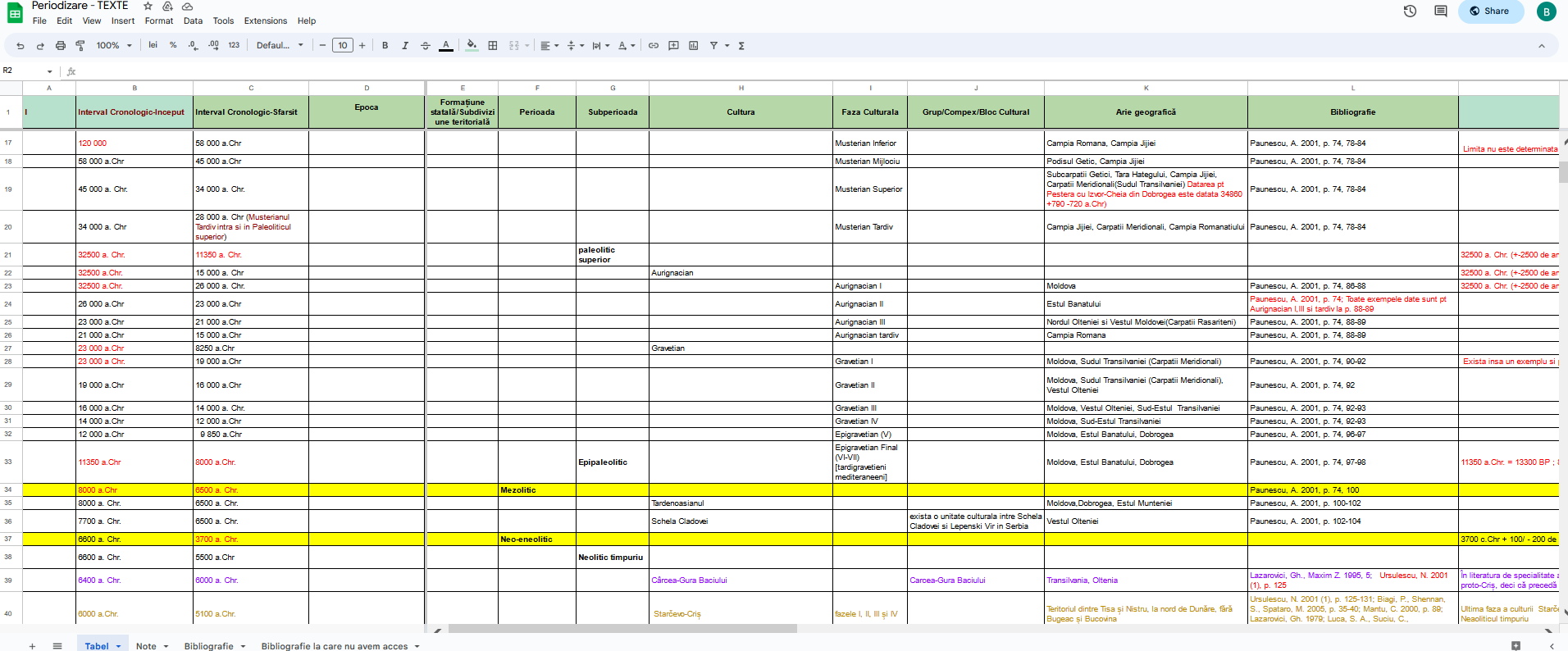
Creating a thesaurus or at least a list that would include all the chronological periods and eras used by archaeologists in Romania had been a priority for a long time. The concepts most used in prehistoric archaeology in Romania are the cultures that name ceramic styles. However, there are different opinions about the duration of archaeological cultures, especially when it comes to the question of their spatial extensions. Also, different names are used for the same culture, which are selected either by the archaeologists or resulting from local variations manifested in material culture. As a result, the RAN team decided to start a project to create a list of time periods to later integrate into PeriodO. The established method was to list all the intervals defined as periods, epochs or cultures in Romanian archaeology and to record them in a hierarchical list organised on three levels: first level: epoch (e.g. stone age, metal age); next level: period (e.g. neolithic, bronze age) and the third level: culture (e.g. Gumelnița). Each of these three levels is described by a time interval, a geographical area where it occurs, a bibliography and analogies with other cultural spaces. In accordance with PeriodO principles, we agreed to record all former opinions and views stated by Romanian archaeologists over a certain time frame. At the moment, the conversion to the PeriodO format has been completed and all the data will be imported into this gazetteer.
NIH's contribution to the ARIADNEplus catalogue totals 22,300 cultural resources, of which 18,277 are of the site/monument type and 4021 are fieldwork reports. They come from two repositories managed by the Digital Heritage Department: the National Archaeological Repertory and the Chronicle of Archaeological Research. For preparing the resources for integration in the ARIADNE Content Cloud the activities of the NIH team pursued two objectives: on the one hand, enriching cultural resources with quality data such as spatial positioning through geographic coordinates in the WGS84 system, correcting controlled vocabularies, uploading representative photos for archaeological sites and establishing a stable connection between RAN and Chronicle, and, on the other hand the data aggregation to AO-Cat required the writing of conversion programs and the realisation of term alignments with Getty AAT. A separate project represented the realisation of the hierarchical list of archaeological periods used in Romanian archaeology, which were defined as time intervals that occur in certain geographical areas.
The process of aggregating archaeological data from Romania in the ARIADNE catalogue was a good opportunity to carry out data improvement activities on the one hand and to develop some system components on the other.
One achievement was the increase in the number of photographs to illustrate the archaeological sites from 50,000 images to more than 100,000. In order to achieve that target, we designed a new specific tool for uploading and describing photographs, as a module of the National Archaeological Repertory database management system. Simultaneously we managed to increase the number of archaeological sites spatially delimited by geographical coordinates by over 10,000. Because of the conditions imposed by ARIADNE ontology we have decided to correct and improve the list of terms that describe the types of archaeological sites in order to transform them into a hierarchically controlled vocabulary. This activity also had a favourable impact on the online consultation process of the RAN database in the original Romanian portal and it was not only a task fulfilled for ARIADNE. Later, the completion of the bibliographic list and the record of archaeological research campaigns for important archaeological sites from Romania was finished. A fifth achievement failed to be finished during the project: the creation of a thesaurus of chronological periods and eras used in Romanian archaeology, but the activity will continue until the end of 2023, when we were expecting to start the process of inclusion in PeriodO. Our intention is to convince the archaeological community from Romania to use this thesaurus of periods in two steps: first, to be adopted for use in excavations reports with the aim of becoming an official list and second to be used in scientific papers.
In the end, to meet the requirements of AO-Cat we needed to align archaeological subject terms extracted from the RAN database with the Getty AAT, and the most appropriate terms were those coming from the two hierarchical lists describing site types. In the end, about 5000 terms were aligned to the Getty AAT.
In the immediate future we would like to upload new collections of archaeological sites to the ARIADNE portal. We will use all the experience gained during the last ARIADNEplus project but also the recent improvements of the RAN database content: more terms aligned to Getty AAT and the Romanian thesaurus of chronological periods.
Internet Archaeology is an open access journal based in the Department of Archaeology, University of York. Except where otherwise noted, content from this work may be used under the terms of the Creative Commons Attribution 3.0 (CC BY) Unported licence, which permits unrestricted use, distribution, and reproduction in any medium, provided that attribution to the author(s), the title of the work, the Internet Archaeology journal and the relevant URL/DOI are given.
Terms and Conditions | Legal Statements | Privacy Policy | Cookies Policy | Citing Internet Archaeology
Internet Archaeology content is preserved for the long term with the Archaeology Data Service (ROR). Help sustain and support open access publication by donating to our Open Access Archaeology Fund.
 Home
Home