Cite this as: Gheyle, W., De Decker, S., Stichelbaut, B. 2024 Digging Deeper is Always Rewarding. Policy instruments, challenges and recent research on conflict archaeology, WWI and WWII in Flanders, Internet Archaeology 66. https://doi.org/10.11141/ia.66.12
In 2017, the government of Flanders decided to award yearly grants for synthesising research on archaeological data produced via development-led archaeology in Flanders (Belgium). At present, no less than 34 archaeological projects have been financially supported this way. Three of those projects deal with the archaeology of modern conflicts. The project 'Conflict archaeology of the Second World War in Flanders' will be discussed in more detail.
World War II (WWII) archaeology is a very young discipline in Flanders, although the enormous expertise in conflict archaeology of World War I (WWI) caused a turnaround in recent years. Putting all the archaeological information together, it turned out that traces of WWII were already being investigated at 172 sites, far more than expected. Some are targeted excavations on large sites, but mostly they are small traces that came to light by chance. This picture is contrasted with knowledge gained in recent years from historical research and from remote sensing sources. The Centre for Historical and Archaeological Aerial Photography (CHAL) (launched by the Province of West Flanders, In Flanders Fields Museum, and Ghent University) plays an important role here. Over 43,000 historical aerial photographs taken during both World Wars provide a unique overview of the war landscape in Belgium and offer enormous archaeological potential today. A combination of analysis of the digital elevation model of Flanders for the above-ground preservation of war traces and the archaeological information from excavations give us an unseen landscape insight.
Corresponding author: Wouter Gheyle
[email protected]
Archaeological Project Coordinator, Heritage service, Province of West Flanders
Sam De Decker
[email protected]
Archaeologist, Heritage Department, Flemish Government
Birger Stichelbaut
[email protected]
Archaeologist, Centre for Historical and Archaeological Aerial Photography, Ghent University
Figure 1: A schematic representation of the strategically important areas in Belgium during the Second World War, combined with the 172 archaeological sites with traces of WWII. 1) Albert Canal defensive line; 2) Main resistance line Koningshooikt-Waver (KW line); 3) Anti-tank ditch Antwerp; 4) Bridgehead Ghent; 5) Diversion channel of the Lys; 6) Lys; 7) Atlantikwall. [Auf Deutsch]
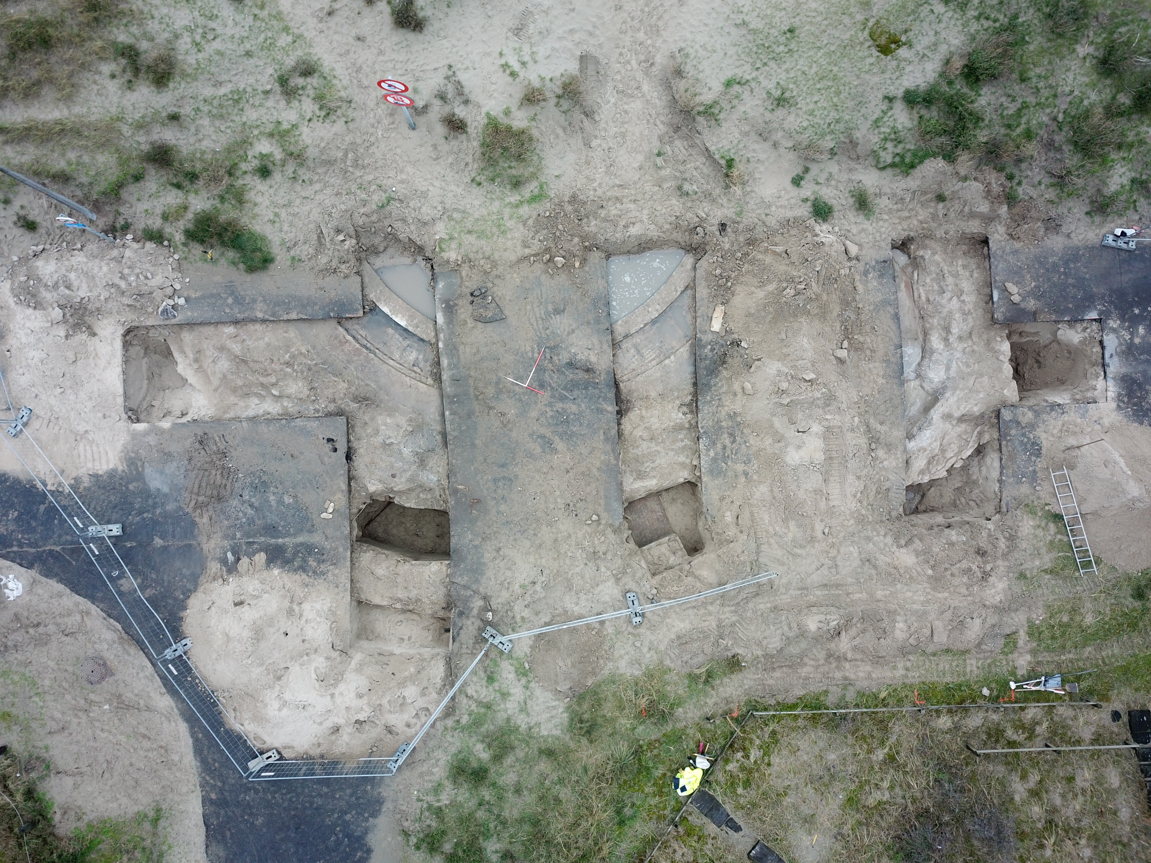
Figure 2: Remains of a German coastal artillery-base, part of the Atlantikwall, hidden under a street. Koksijde - Groenendijk (Image: Raph De Brandt)
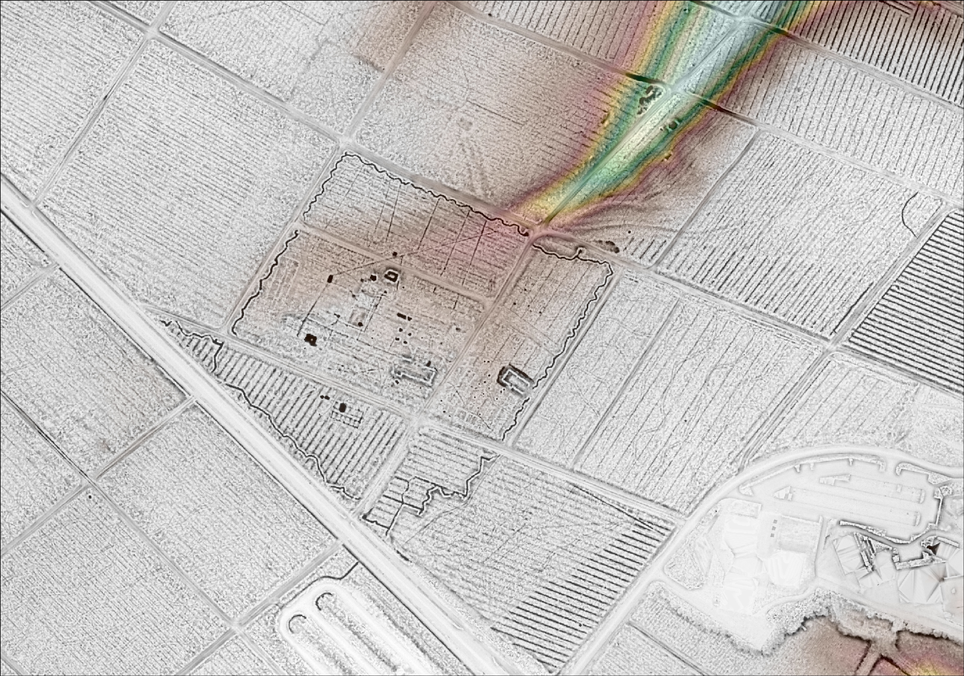
Figure 3: Much of the German radar base in Lanaken 'Hansenhöhe' still remains in the forest (National Park Hoge Kempen). On the digital height model we clearly see the trenches around the camp, contours of buildings and radar posts and even ditches of suspected utility lines (UGent/Information Flanders)
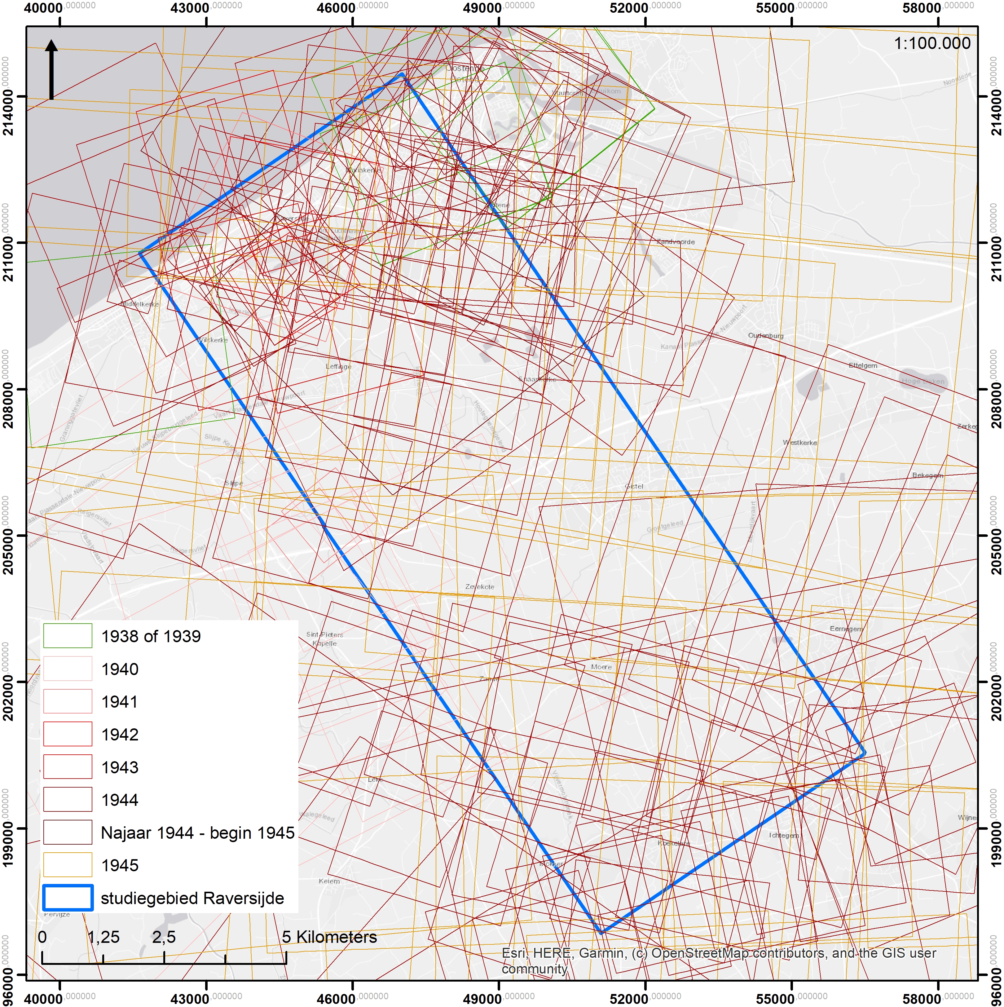
Figure 4: Coverage of a study area along the coast (Raversijde-Koekelare) with 178 historic aerial pictures.
Council of Europe 1992 European Convention on the Protection of the Archaeological Heritage, European Treaty Series 143, Strasbourg: Council of Europe. https://rm.coe.int/168007bd25
De Brant, R., Heynssens, N., De Logi, A. and Hoorne, J. 2017 'Maldegem Ringbaan. September 2017 - Juni 2018', onuitgegeven rapport, Adegem. https://loket.onroerenderfgoed.be/archeologie/notas/notas/3879
De Brant, R., De Kreyger, F., De Logi, A. and Hoorne, J. 2018 'Maldegem Krommewege Zuid, November 2017 - Januari 2018', onuitgegeven rapport, Adegem. https://loket.onroerenderfgoed.be/archeologie/notas/notas/7606
Deville, T., Houbrechts, S., Simons, R. and De Nutte, G. 2020 'Nijverheidslaan te Opglabbeek. Nota door middel van proefsleuven', onuitgegeven rapport, Hasselt. https://loket.onroerenderfgoed.be/archeologie/notas/notas/16104
Gheyle W., De Mulder G., de Meyer M., Bracke M., De Brant R., De Decker C., Hoorne J., van den Dorpel A., Van Goidsenhoven W., Verdegem S. and Stichelbaut B. 2022 Archeologie van de Tweede Wereldoorlog, SYNTAR 011. https://doi.org/10.55465/IEKG4469
Gheyle, W., Stichelbaut, B. and Verdegem, S. 2021a Dataset archeologisch syntheseonderzoek loopgraven Eerste Wereldoorlog in Vlaanderen (UGent) [Data set], Zenodo. https://doi.org/10.5281/zenodo.4740452
Gheyle W., Stichelbaut B. and Verdegem S. 2021b Loopgraven uit de Eerste Wereldoorlog, SYNTAR 002 https://doi.org/10.55465/XLDB6085
Gheyle, W., Stichelbaut, B. and Verdegem, S. 2021c Registratieformulier voor het opgraven van loopgraven - archeologisch syntheseonderzoek loopgraven Eerste Wereldoorlog in Vlaanderen (UGent), Zenodo. https://doi.org/10.5281/zenodo.4740474
Hoorne, J., De Mulder, G., Ryssaert, C., Bartholomieux, B., Berkers, M., De Doncker, G., Iserby, N. and Klinkenborg. S. 2008 Sint-Denijs-Westrem - Flanders Expo Zone 1&2: Archeologisch vooronderzoek en wegkofferbegeleiding van 12 tot 23 juni en v. 27 tot 28 sept, 2007 (stad Gent, provincie Oost-Vlaanderen), UGent Archeologische Rapporten 9, Gent: UGent.
Stichelbaut, B. and Gheyle, W. 2022 Dataset: GIS bestanden met gekarteerde sporen uit WO II [data set]. Zenodo. https://doi.org/10.5281/zenodo.7224915
Stichelbaut, B. and Hoorne, J. 2008 'The Airfield of Sint-Denijs Westrem: an aerial photographic perspective', Paper presented at the Fields of Conflict Conference, Ghent, 2008.
Van Bavel, J., MIiedema, F.R.P.M. and Alma, X. 2017 'Hannuitsesteenweg (Schietstand), Tienen. Een Archeologienota: VEC Nota 210', onuitgegeven rapport, Brugge. https://loket.onroerenderfgoed.be/archeologie/notas/notas/4910
Internet Archaeology is an open access journal based in the Department of Archaeology, University of York. Except where otherwise noted, content from this work may be used under the terms of the Creative Commons Attribution 3.0 (CC BY) Unported licence, which permits unrestricted use, distribution, and reproduction in any medium, provided that attribution to the author(s), the title of the work, the Internet Archaeology journal and the relevant URL/DOI are given.
Terms and Conditions | Legal Statements | Privacy Policy | Cookies Policy | Citing Internet Archaeology
Internet Archaeology content is preserved for the long term with the Archaeology Data Service (ROR). Help sustain and support open access publication by donating to our Open Access Archaeology Fund.
 Home
Home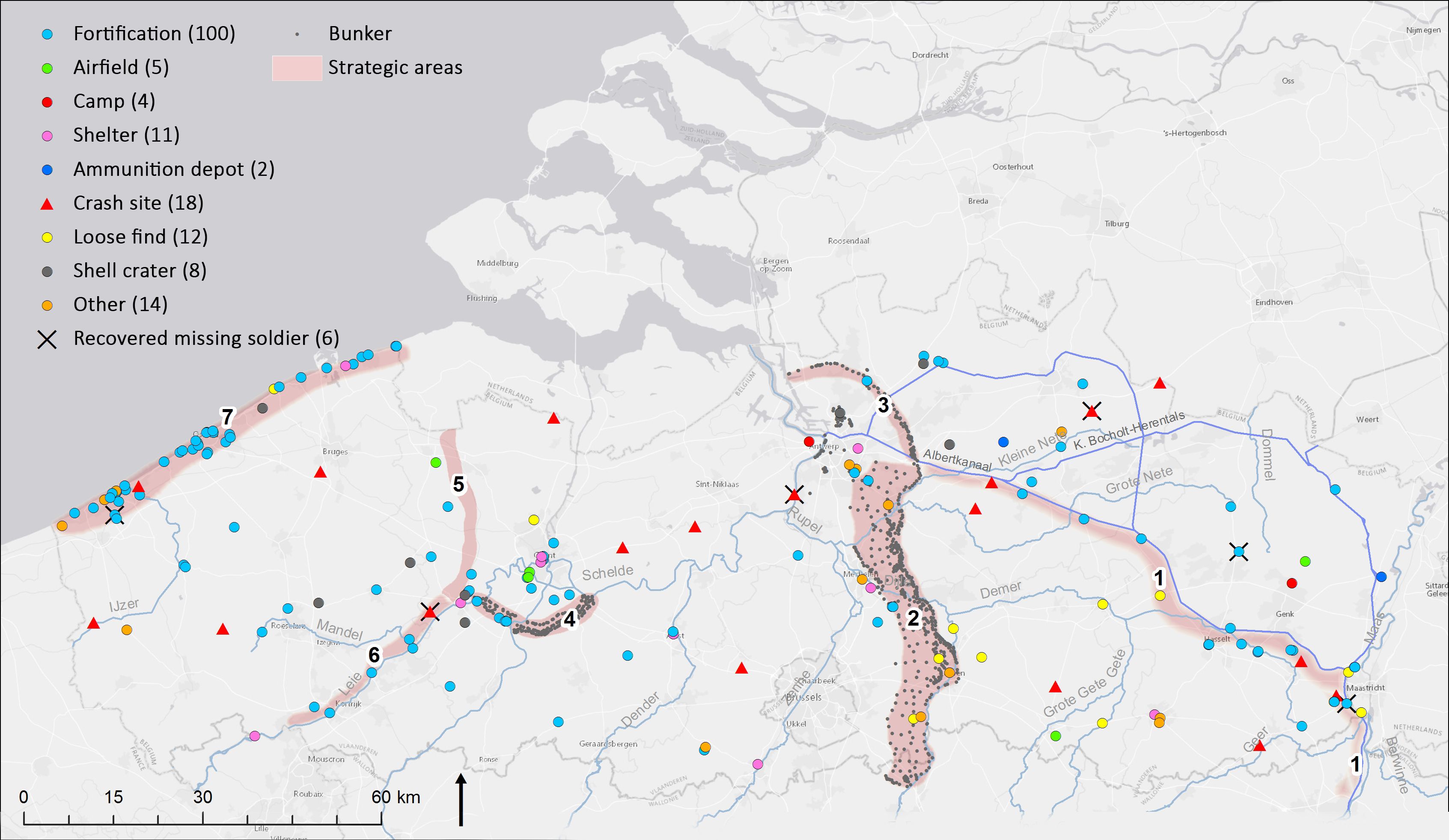