Cite this as: Steigberger, E. 2024 Another Case of Making Choices: Alpine terrain, large-scale sites and mass finds of the 20th century, Internet Archaeology 66. https://doi.org/10.11141/ia.66.7
Excavations of sites from the 20th century in Austria started around the beginning of the millennium. Before then, such remains were always part of excavations, but not the specific reason for archaeological interventions. That changed and thus new challenges for heritage management developed. Austria, as part of the Third Reich, has a legacy of massive changes in its cultural landscape resulting from warfare and the National Socialist (NS) -concentration and forced labour camps. As a result of rescue excavations, more and more sites that had previously been lost have re-appeared.
Since the Austrian Monuments Protection Law does not have a specific time limit, monument protection for remains from the 20th century can be the result of an evaluation process without affecting prehistoric or historic sites. Naturally, the necessary historic value can derive from a different perspective and can contain important specific aspects.
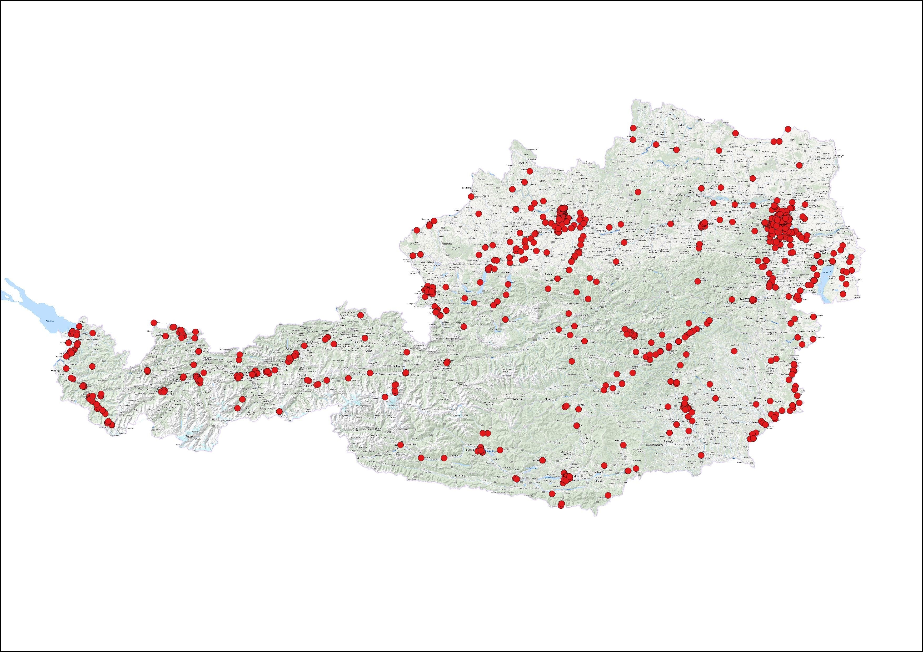
In order to get an overview about the sites of specifically built NS-camps, in 2019, the Monuments Authority started a project to catalogue these in two phases. The results are both as expected and overwhelming in their sheer numbers. So far, we know of 2113 camps in Austria, and only about half of them can be exactly located. The main and 'infamous' sites of the Mauthausen and Gusen concentration camps are already well known and protected; many others are still waiting for evaluation.
In addition to the catalogue and this interactive map, Paul Mitchell, Thomas Atzmüller, Peter Hinterndorfer and myself published a short analysis in our annual Fundberichte Österreich (Mitchell and Steigberger 2020). As already clearly visible on the map, most NS-built camps outline vast so-called 'Lagerlandschaften', areas of connecting camps that supplied the industry with a cheap workforce. Clearly visible are camps along rivers accompanying power plants e.g. along the River Ill in Tyrol, housing forced labourers used to build these chains of power plants. In addition, the main industrial centres, like Linz in Upper Austria and Vienna, show a concentration of such camps. The chain of camps along the eastern border with Hungary marks the forced labour camps housing workers to build the so-called 'Südostwall' that will be discussed later (Figure 1).
However, not only World War II but also World War I has left us with huge camp complexes that have to be located and evaluated. One example in Styria illustrates the dimensions and surprising remains of infrastructure. A small town of about 4000 inhabitants swelled to over 40,000 in 1915, when the huge prisoner-of-war (POW) camp was built. POWs worked in the nearby stone quarry, built barrack elements for other POW camps throughout the whole monarchy, and developed experimental narrow-gauge railway trains on a steep slope nearby (Dornik and Steigberger 2017).
In order to actively deal with these sometimes very large areas, we need to locate them. The Monuments Authority is the only one who can collect the necessary data, provide storage, make the archive available for further use, update it regularly and, if necessary, take steps to document or preserve the remains. The work on such lists and catalogues is ongoing and is additional to the more traditional topics archaeologists in heritage management face on a daily basis. The list provides the Authority with the necessary information on quality, quantity and distribution of camp structures in order to apply this information to individual legal processes in order to protect them.
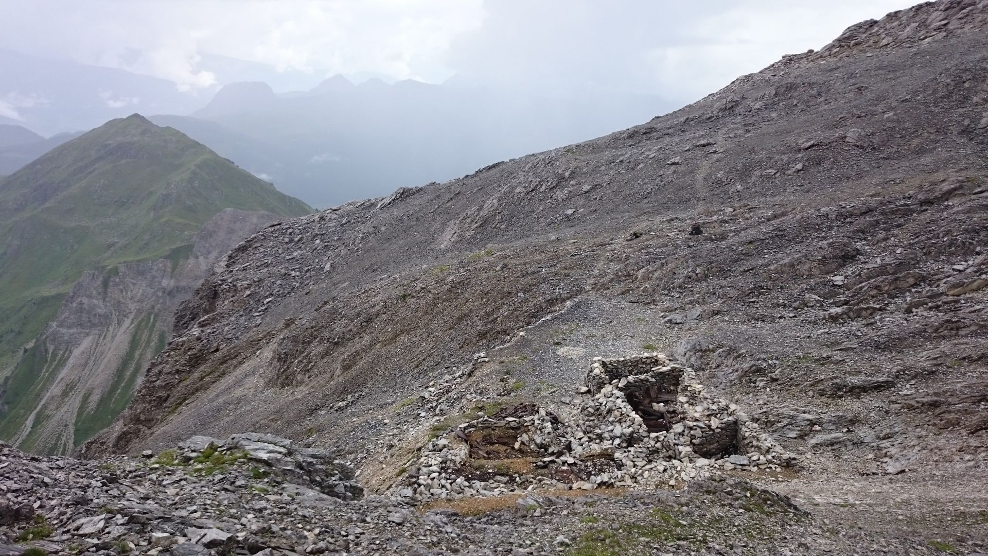
The Alpine frontline along the Carnic Crest is a large, linear site that has very specific requirements regarding heritage management - not just due to the alpine terrain and the preservation on site, but also because of climate change and retreating glaciers. The bilateral hiking trail along the Carnic Crest brings its own challenges. Monument protection, cataloguing of sites, monitoring and preserving are tasks, as is making choices. What do we know, what can be protected, what can be preserved? Two examples, one in East Tyrol and one in Carinthia, show methods of monument protection and site management. After heavy fighting in 1915, the war quickly turned into trench warfare. In this context, the mountain front was heavily fortified until 1916 for permanent defence. The remains of these fortifications, paths, and residential and functional barracks in the area today were recorded using descriptions, photos, GPS mapping and 3D terrain models. These recordings formed the basic framework for the presentation of two protection reports (Pöll and Steigberger in press). Since the beginning of 2019/ 2020, the military buildings on the Carnic Ridge in Kartitsch and in Rattendorf have been listed.
The project in Tyrol started because of an initiative by the municipality of Kartitsch. Excavations and conservation work followed from 2014 to 2017. The project is still running, aiming at a digital hiking guide compiled by Rupert Gietl from ArcTeam, a new concept for public information in Kartitsch, and a management plan for the monument comparable to that for the site of Großglockner Hochalpenstraße/Großglockner High Alpine Road, which is on a provisional list to be a UNESCO World Heritage Site.
On-site mapping followed aerial photo sighting, historical data collection from various archives for the selected region and detailed terrain mapping in two stages. Fieldwork had to be done in teams of two with simple equipment, to be quick and efficient: photographs, description on a standardised form and taking GPS coordinates. Further processing of maps based on the GPS data resulted in an object catalogue and a detailed map of 892 individual objects and 59 zones along 11km of the Carnic Crest.
Some examples of the almost 900 individual objects recorded include posts, buildings, a cable car, and cemetery. Objects are in very different conditions; many small finds were on the surface right along the hiking paths and in the collapsed building sites. For a few objects, a historical identification was possible through historic photographs (Figure 2).
Overall costs, fully paid for by the Monuments Authority and therefore the taxpayer (€27,112), included external expertise, two six-day field trips for the three teams of two archaeologists, digital GIS-based plans, and research at the Staatsarchiv.
Following the front line to the east, lies the area of modern-day Carinthia. In the district of Hermagor lies the small village of Rattendof. Towards the south, the last mountain range of the Carnic Alps forms the border with Italy.
After our experience with terrain, the scale and the variety of finds and structures, along with the development of new technologies, we decided to apply different methods to map this area from 2017 to 2018. From a first visit on foot to the designated area, we knew of many building structures on various levels and slopes, connecting paths, the foundations of a cable car for the transport of goods, water pipes and wells, and artillery posts. For a detailed mapping of archaeological features and terrain, we contacted Crazy Eye and discussed drone flight and 3D-modelling for our purpose.
The work on site was significantly shorter than a traditional survey and offered a georeferenced model that can be surveyed from various angles (see model). The actual field days to collect the necessary data for the model were limited to four days, followed by digital processing and parallel research in archives. The overall cost was about €11,450 for 3D model field research and for two one-day trips for two archaeologists to describe the objects, take individual photographs, and undertake digital mapping on-site.
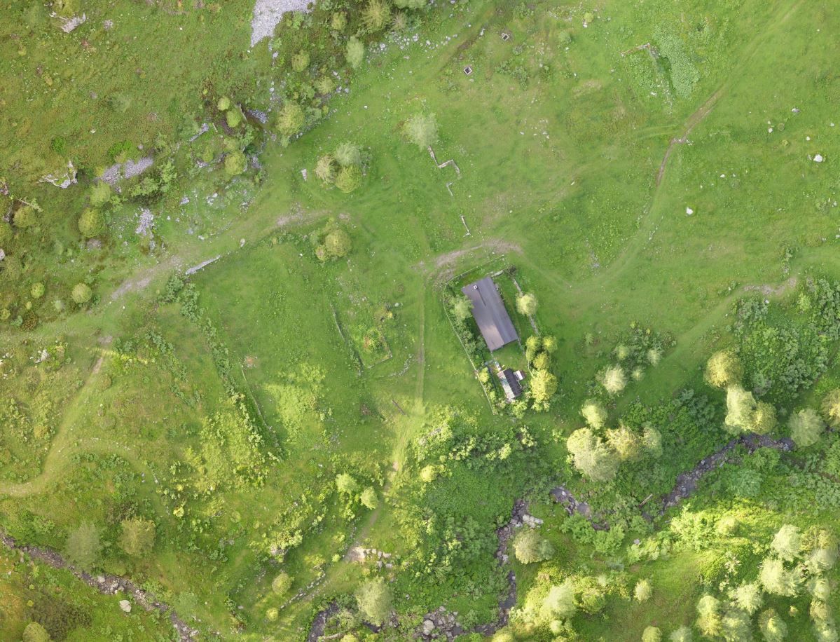
Now, why the Upper Rattendorfer Alm? During the first trip, it was already clear that it was an intensively used area, similar to the one at Obstanzer Sattel identified during the research in the Tyrol. It also had a chapel on the lower part of the Alm, with infrastructure and various buildings on different levels of the slope towards the front line on the ridge. In one case, one of the barracks still partially stands in very good condition and in use as a private hunting lodge.
The historical photograph allows us to identify the structure as a second barracks for the troops (Figure 3). Some of the better-preserved structures still have walls, windows and doors intact. As during the research in Tyrol, we also found wooden beams, wooden flooring, wooden inner wall structures and many small finds still lying on the site surface.
The survey showed that the Upper Rattendorfer Alm is remarkably undisturbed by modern activities, differing significantly to the Tyrolean case. It has a great variety of features and a lot of information in the archives. A bowling lane right behind the first lines is only one of the features that marks the site as special. Further down into the valley, the barracks of a POW camp and additional barracks lie well below the front line but were connected to the Upper Rattendorfer Alm via a transport cable car. The recording, mapping and cataloguing were done precisely and efficiently, but still in an accurate way in order to ensure the necessary legal security and precision.
Another example of a linear structure that covers almost the whole border to the east is the so-called 'Südostwall'. This was built in the last weeks of World War II not only by forced labour but also by 'Hitlerjugend' and Jews on the Death March to Mauthausen. Is it worth protecting? What do we protect? The building of the NS-war machinery? The site as a monument to forced labour? The site representing the only visible traces of people walking to their deaths?
In order to define an archaeological monument, one has to decide which part of the site, if not all, is actually of historical, cultural or artistic value in order to adhere to the Austrian Monument Protection Act. For the linear sites on the Carnic Crest, two procedures were tested and both resulted in monument protection. However, the situation of the Südostwall is rather different. With sites on a high mountain ridge, only modern-day tourism and pasture farming need consideration. The Südostwall runs through low-lying areas along the border to Hungary and through intensively used land. It consists of a series of ditches and smaller structures, not all of them connecting. Some parts are still visible above ground but most parts survive only below the surface. A small part of the Südostwall is considered a protected monument, but the discussion is still ongoing on how to define a linear monument along the whole border. It is likely that the Monument Act requirement for such a legal procedure will result in a lot of work and consideration. In regard to the historical value, it would be a monument preserving the work of Jews on the Death March alongside hardcore Nazis, 'Hitlerjugend' boys, forced labour workers and 'Bund Deutscher Mädchen' girls. Still, these issues need to be addressed and taken into consideration.
Three large development projects brought a huge mass of finds from the NS-period to light. The development of new urban districts in Graz and Linz resulted in extensive rescue excavations.
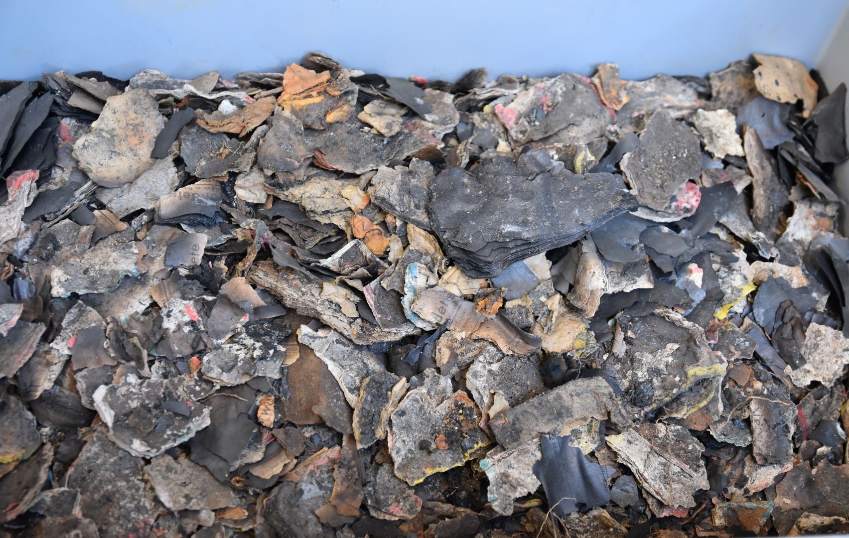
In Graz Puntigam, at a brewery that used forced labour and was the target of massive bombardment because of its vicinity to Graz Main Station, excavations unearthed finds from industrial production as well as a huge complex of paperwork from the NS-administration. Heavy machinery was necessary to transport these finds into storage and then identification, classification and evaluation had to begin (Figure 4).
During the development of a hydroelectric power station in Graz Liebenau, the remains of a forced labour camp that was 'Aussenlager' to Mauthausen and a station of the Death Marches of April 1945 brought its own problems. The question of mass graves in the area is still unanswered, but needs to be addressed with stakeholders and the public. All finds from both sites were sorted and then stored in groups. In a second process, a few well-preserved or otherwise remarkable items in each category were defined and brought into museum storage where the evaluation and interpretation process are underway.
At the SS-barracks at Linz Ebelsberg, still ongoing excavations fill the cellars of the old military buildings with all sorts of NS-related finds. Here, the period of the American occupation also shows in the archaeological record - a whole chronology of post-war Coca-Cola bottles is now available.
The same procedure as in Graz has been conducted here. Experts identify the findings, define groups, catalogue the whole assemblage, then propose what to keep. A commission of three people, two heritage managers and the excavation's lead archaeologist, go through all the finds on display and decide if the defined items will go into storage for research. Of course, all items found are photographed, described and counted, and the exact location and situation of the findings is always recorded as carefully and diligently as it would be for a prehistoric find. The evaluation process and the decision on what to keep happens much later after careful consideration. For Linz Ebelsberg, there are three barracks cellars, two large garages and the first-floor storage of one barracks full of items. This is the result of about half of the planned excavation and already there have been two phases of de-acquisition.
The Austrian Monuments Authority develops guidelines and deals with the decision-making process on a day-to-day basis. Historically difficult topics need to be considered in this process which must be very consistent, very clear and very transparent for all partners and the public. Strategies have been developed and processes established (e.g. when dealing with human remains in mass graves) together with the Interior Ministry and the police (Theune and Steigberger 2023). Mass find complexes are always individually evaluated and a process is established for the specific requirements. These processes require high personal engagement by our colleagues and broad knowledge not only on legal topics but also on the conservation of materials not typically expected on archaeological sites, such as aluminium or Bakelite. Contacts with specialists are very important in order to find a proper solution in every case. The sheer mass of sites that include industrially-produced mass finds seems overwhelming at times, and only stringent decisions will help us to deal with it.
Internet Archaeology is an open access journal based in the Department of Archaeology, University of York. Except where otherwise noted, content from this work may be used under the terms of the Creative Commons Attribution 3.0 (CC BY) Unported licence, which permits unrestricted use, distribution, and reproduction in any medium, provided that attribution to the author(s), the title of the work, the Internet Archaeology journal and the relevant URL/DOI are given.
Terms and Conditions | Legal Statements | Privacy Policy | Cookies Policy | Citing Internet Archaeology
Internet Archaeology content is preserved for the long term with the Archaeology Data Service (ROR). Help sustain and support open access publication by donating to our Open Access Archaeology Fund.
 Home
Home