
Cite this as: Tuck, A. 2025 'A State of Things Which Ought Not to be Permitted': Excavation of 19th-century slums (Bull Yard, Horn Yard, Swan Yard and Market Alley) surrounding Bank Street at 'The Charter', Gravesend, Internet Archaeology 69. https://doi.org/10.11141/ia.69.11
Excavation was commissioned by Paul Eldred of Gardiner & Theobald LLP as part of the development of 242 residential units and a multi-storey car park. Gravesham Borough Council granted planning permission (planning references 20120931 and 20200343) under advice from Casper Johnson, County Archaeologist for Kent County Council. The excavation was part of a staged approach to archaeological investigation that began with two desk-based assessments (Waterman 2012 and CgMs 2018) and included a borehole survey (Waterman 2012) and a trial trench evaluation (Wessex Archaeology 2020a). The presence of 18th- to 19th-century cellars on the site was already known, recorded in the Kent HER (TQ67 SW231). The results of the mitigation excavation were assessed in a previous report (Wessex Archaeology 2022).
Sites like these can often be overlooked by the planning process, with 18th/19th-century domestic, commercial and industrial remains sometimes attracting less thorough archaeological scrutiny than those from earlier periods. The excavation of this site is a good example of the valuable information that excavation and other forms of investigation can provide, revealing previously unknown information that goes beyond that available on historical maps, photographs and textual sources.
The study of the 19th century can often focus on technological progress, with factories, foundries and other functional apparatus presented as possessing some inanimate agency stripped of the people who operated them. Where human beings are allowed into the narrative, it is often as 'great men' such as owners and managers. The present article is in part guilty of upholding this bias (see Section 7). In general, the higher an individual's class, the easier it is to obtain information about them, allowing for the construction of narratives such as the history of the Gates family presented here. These narratives are valuable and informative. However, this approach overlooks the majority of the population: the workers. The present project has allowed for the investigation of an area primarily occupied by low-status workers' housing, which provides data to inform the low-status experience of the 19th century. This information is particularly valuable from the maritime town Gravesend, as the study of workers' housing has largely focused on London and northern cities such as Sheffield, Manchester, Birmingham and Glasgow (e.g. Nevell 2022).
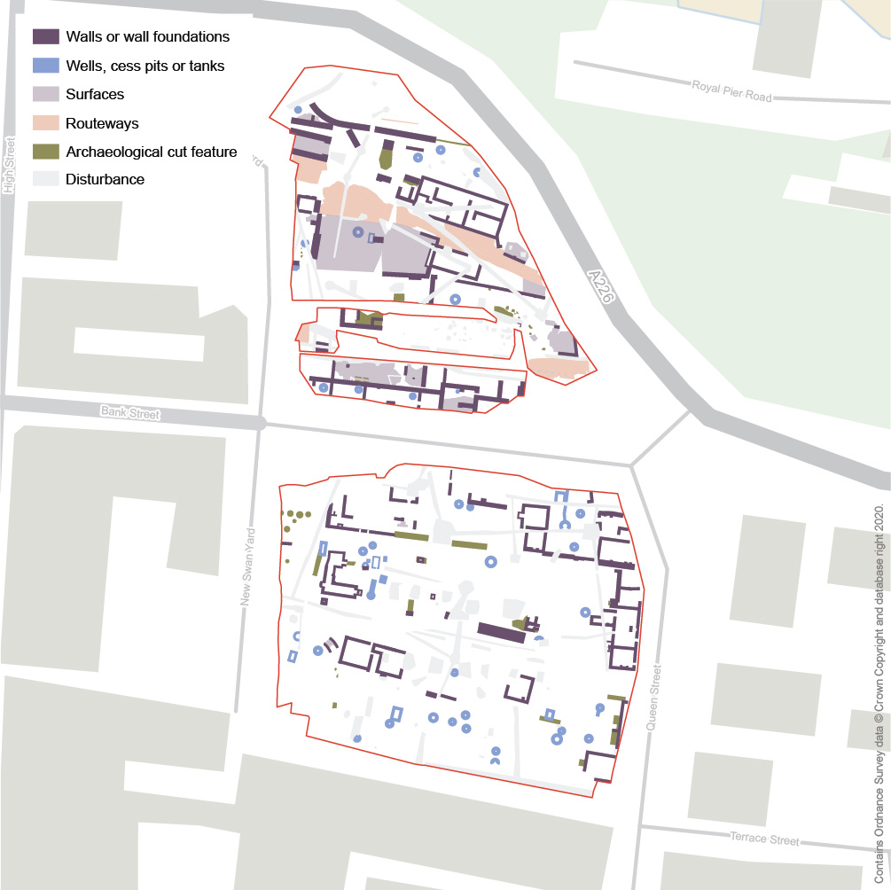
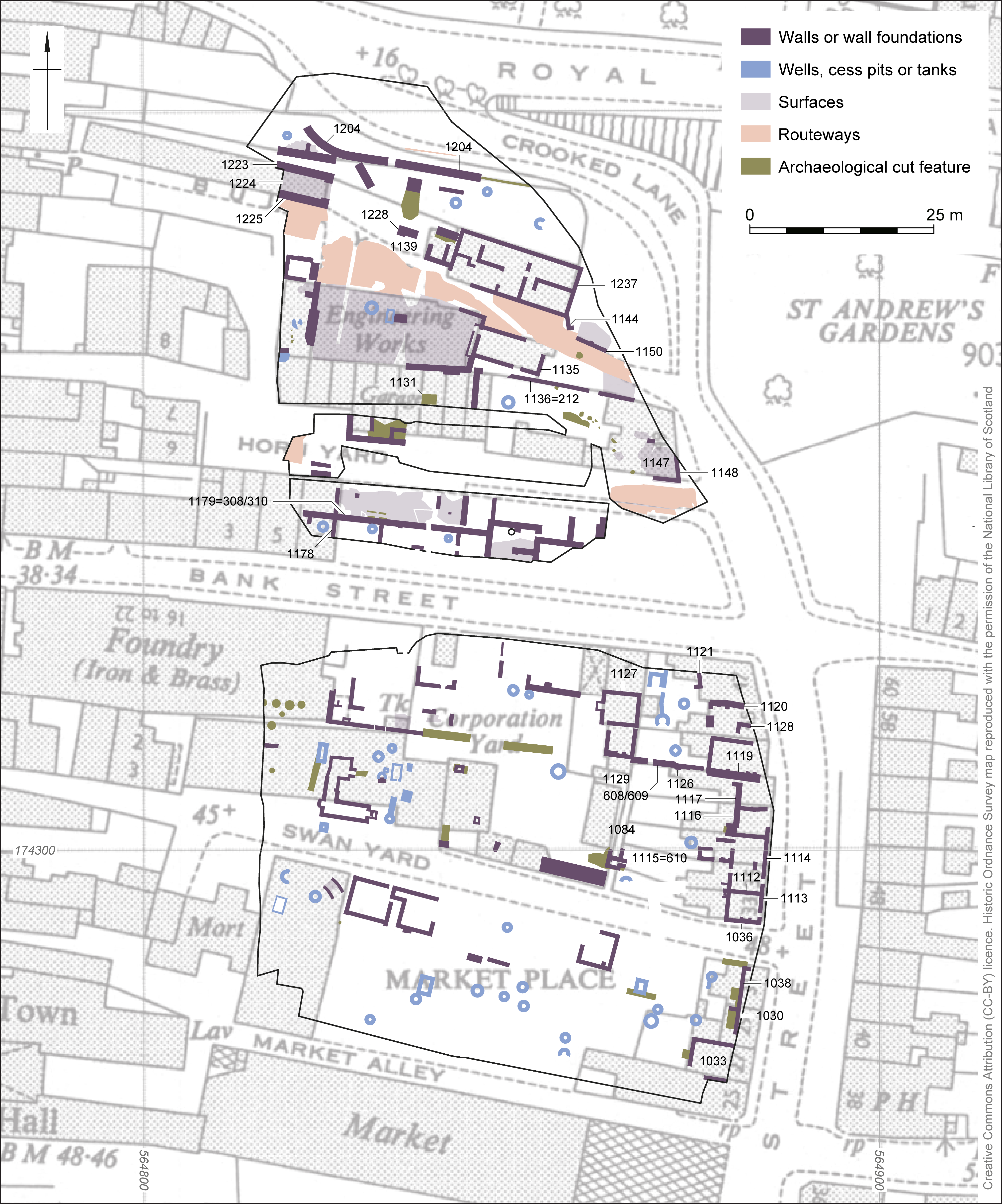
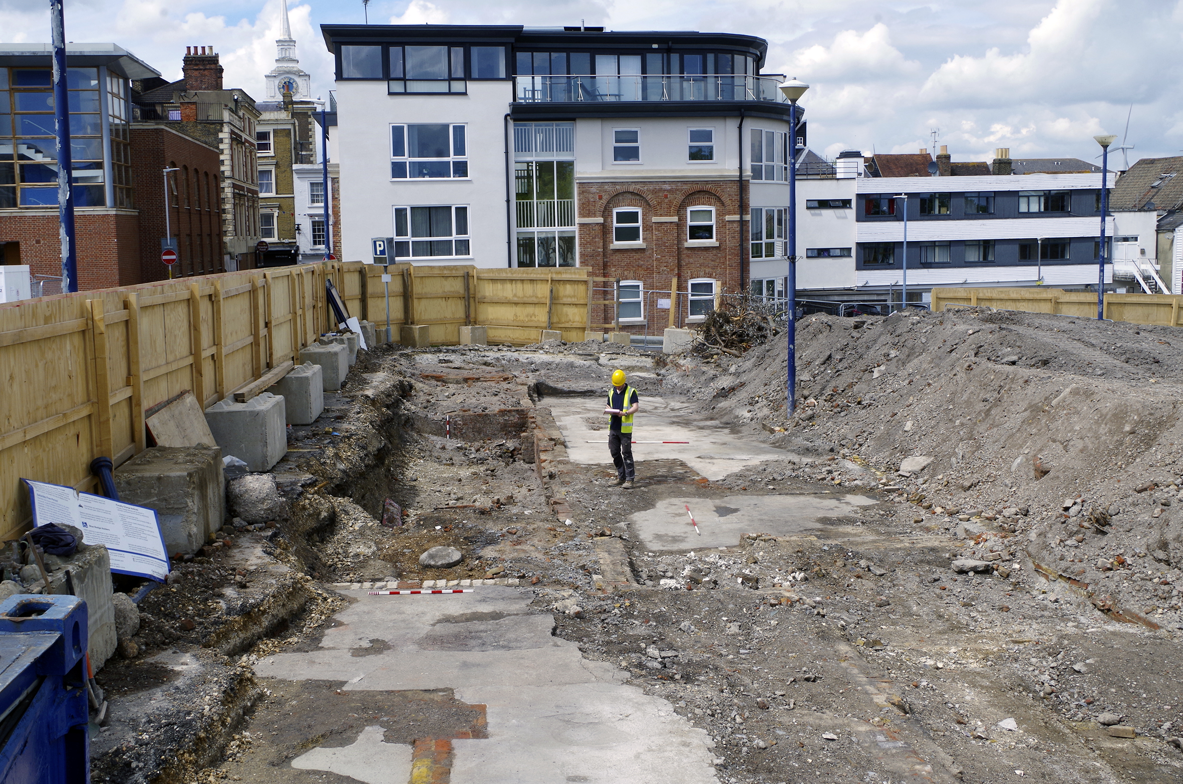
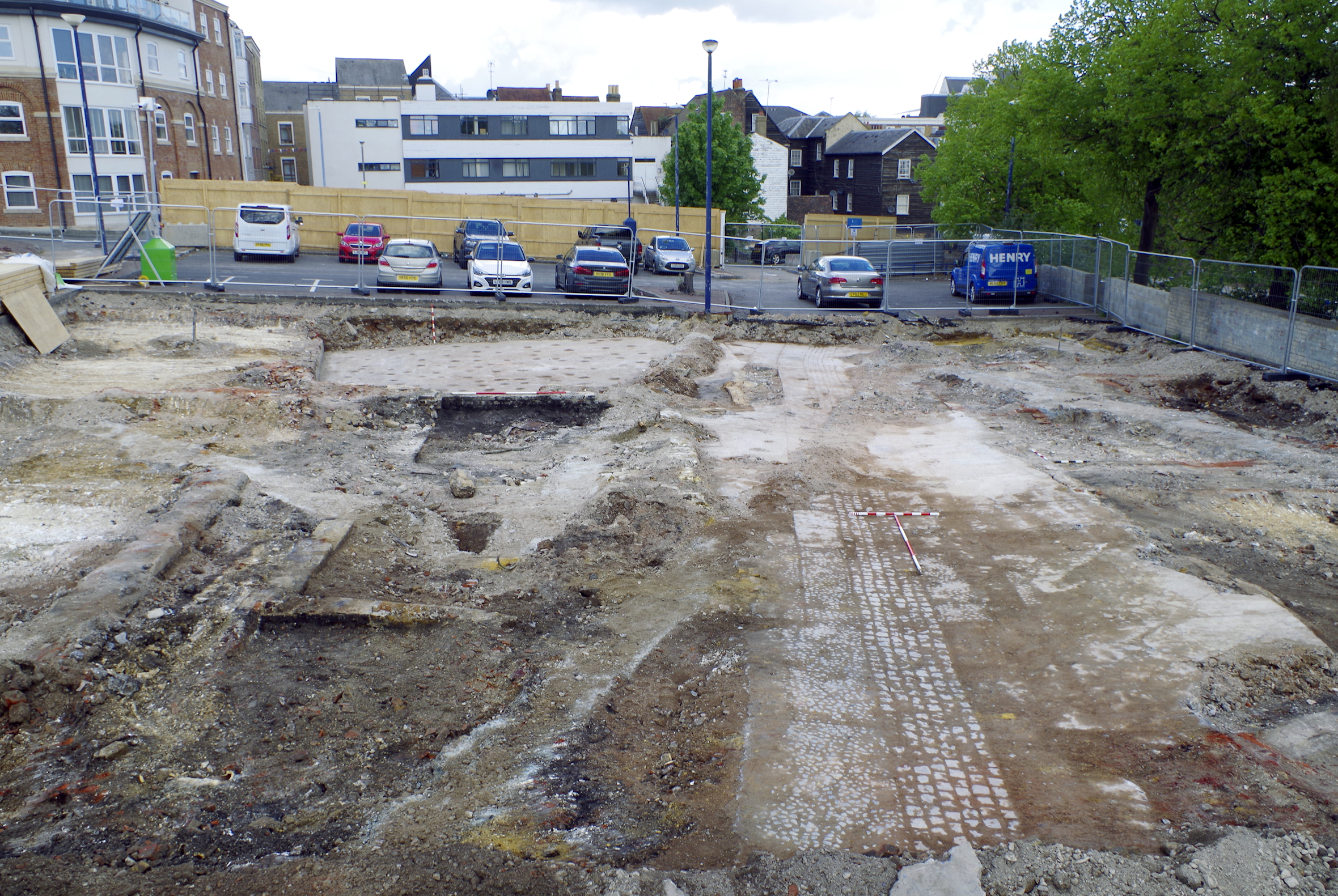
In 2021, a team led by Lisa McCaig of Wessex Archaeology excavated the area of two car parks on either side of Bank Street (NGR 564894 174311; Figure 1). These form part of the 'Eastern Quarter' of the 'Heritage Quarter' in the centre of Gravesend. The site was bounded to the north and east by Crooked Lane, to the east by Queen Street and to the south and west by modern development. Existing ground levels were at 10-17m OD.
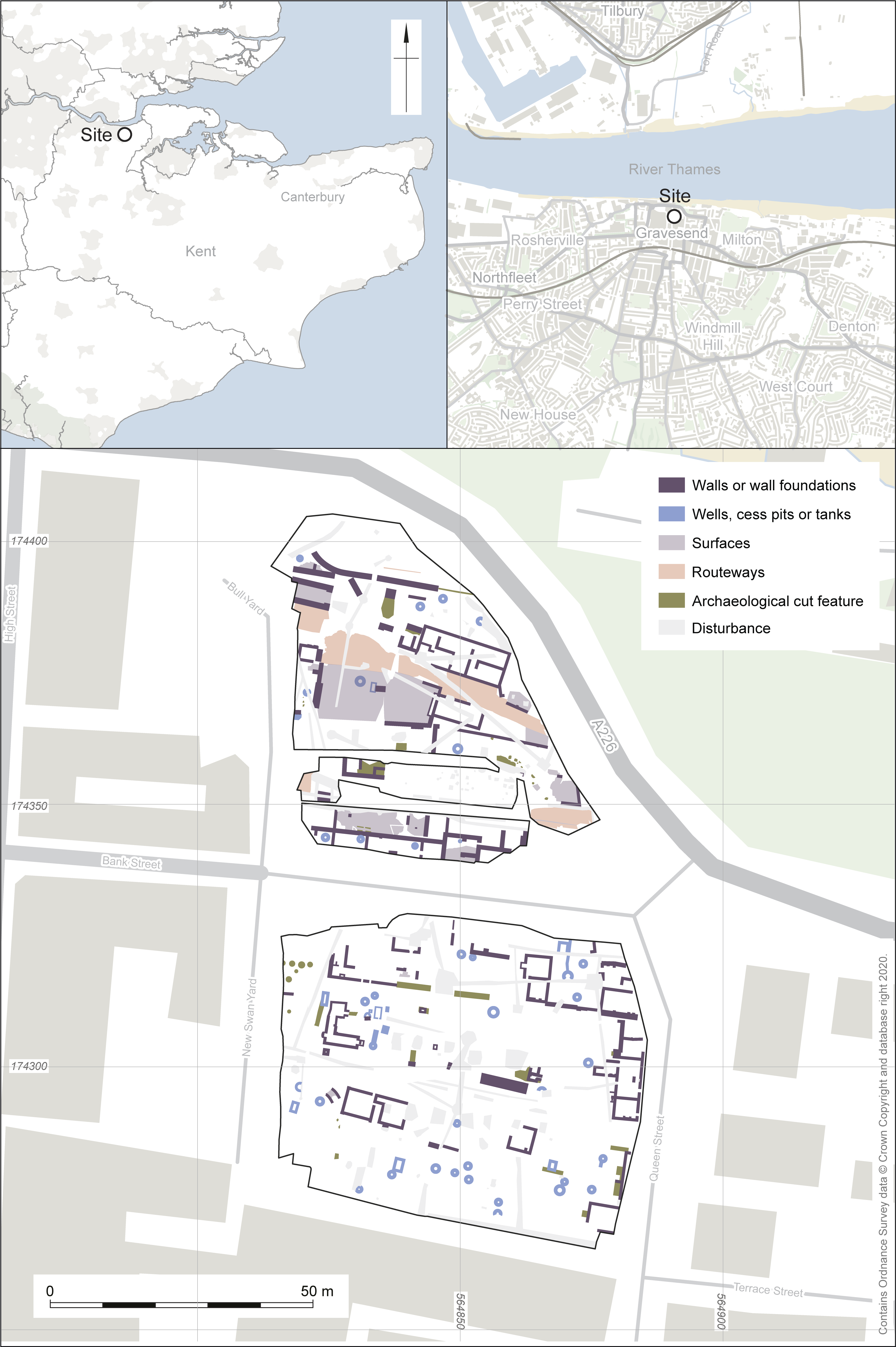
Aerial photographs held by Historic England (2023) shows the site in grainy low definition (EPW009131, EPW009132, EPW009133 and EPW001413). The blurry shortcomings of these valuable photographs parallel the lack of attention the slum areas of the site seem to have received from contemporary observers. The photographs are from the 1920s, a little after the heyday of the site, when redevelopment and clearance had already begun. They provide an overview of the general character of the area. The north side of Bank Street can clearly be picked out, comprising three- and four-storey masonry buildings of some architectural value. By contrast, the area of Swan Yard and Market Alley were a varied jumble of generally timber buildings, street surfaces and some trees. More orderly terraces fronted Queen Street, behind which a coach manufactory was arranged around a courtyard. In the area of Horn Yard and Bull Yard, a tight knot of buildings were probably all of brick.
The underlying geology is mapped as the Lewes Nodular Formation, Seaford Chalk Formation and Newhaven Chalk Formation (British Geological Survey). White chalk bedrock was reached during excavation. Superficial deposits of alluvium and made ground overlay the solid geology, of which the alluvium was associated with the River Thames to the north (British Geological Survey). A borehole survey (Waterman 2012) revealed that made ground deposits were up to 1.5m deep.
Although prehistoric findspots and evidence of Romano-British and Anglo-Saxon occupation are known from Gravesend (CgMs 2018), no evidence of activity prior to the medieval period was identified.
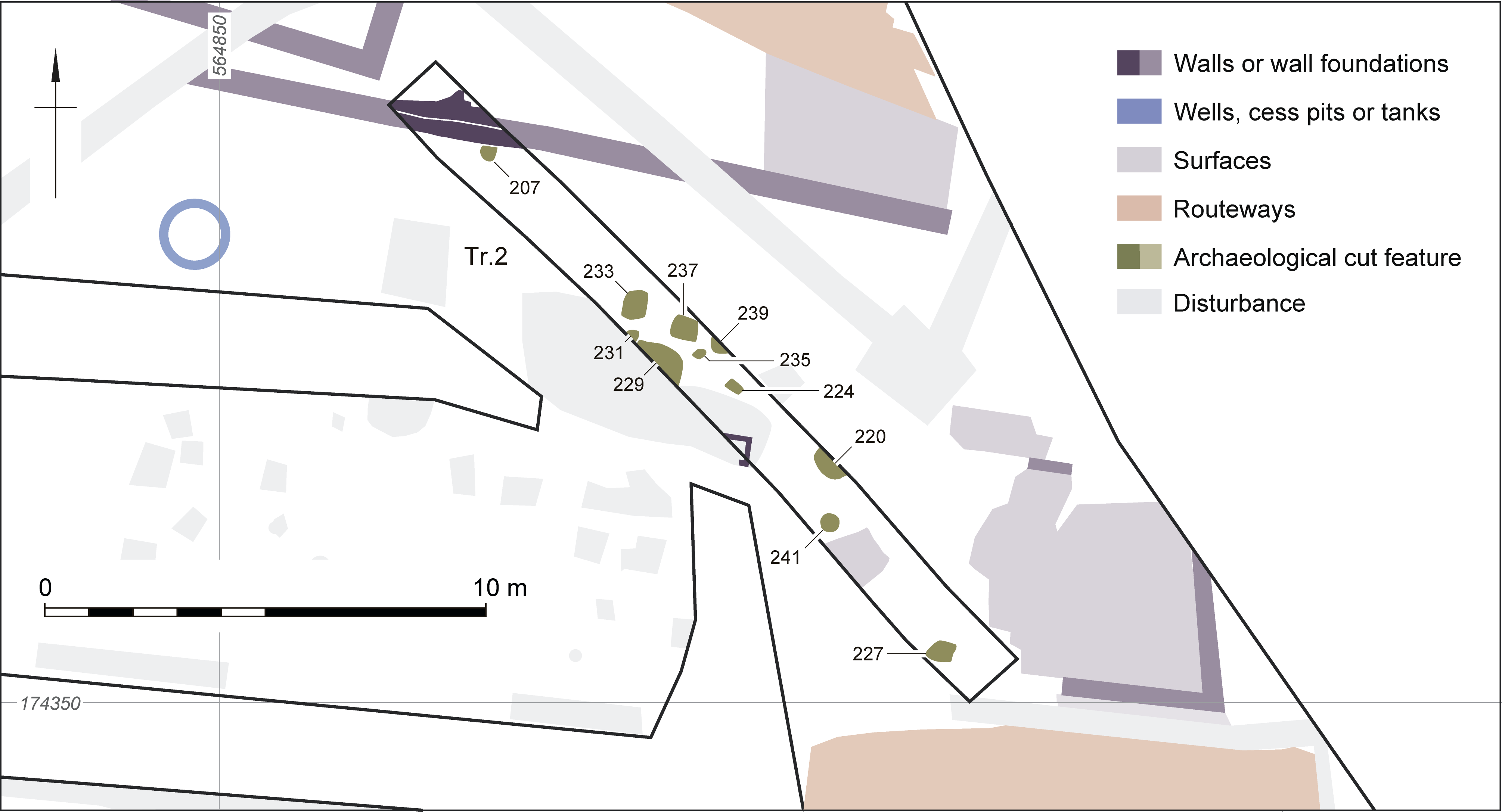
Evidence for medieval settlement of the site was slight. During the trial trench evaluation (Wessex Archaeology 2020b), fragments of medieval roof tile were recovered from three discrete features in trench 2 (207, 220 and 233), with chronologically ambiguous roof tile from four further discrete features (229, 231, 237 and 241). Given the likelihood of fairly lengthy use and reuse of these materials, the tiles should not be relied upon to identify the survival of a phase of features of medieval origin. The medieval tile may have been residual, perhaps having been reused before incorporation into the fills and demolition material found across the site. This is supported by the recovery of post-medieval brick alongside medieval tile in posthole 233. These discrete features (Figures 2 and 3) have been divided into two categories: small sub-rectangular pits (220, 227, 229, 237 and 239) and postholes (224, 231, 233, 235 and 241). They had no particular pattern in plan. The mitigation excavation suggested that features 229 and 231 may in fact have been part of a drain cut, and failed to identify any additional features of these types nearby.
A lack of medieval development is consistent with historic information. The parish of Milton stretched up to Gravesend High Street and this might be a factor in the low level of medieval and early post-medieval development on the east side of the High Street. This area belonged to the monastery of St Mary le Graves, Tower Hill, London, and was part of the manor of Parrock. Development to the east of the High Street north of the Town Hall was limited to two buildings in 1456. Between the Kent public house and Bank Street (i.e. south-west of the site) was the early 15th-century Dame Anne's Hall. North of Bank Street (i.e. west of the site) was an area known as Beelings or Baldwin's Acre. By the 16th century there had been a little more development when William Bourne (c. 1535-1581), innkeeper, mathematician, gunner and mercer, well known for writings on ordnance, inventions and navigation, owned messuages, tenements and gardens on the east side of the High Street (Discover Gravesham 2023a).
The majority of the very modest artefactual assemblage was recovered from unstratified and demolition contexts, and therefore does little to help date and interpret the remains. With the exception of the medieval roof tile mentioned above (Section 1.2), the entire assemblage was from the 19th and 20th centuries.
There are seven poorly stratified glass bottles and a glass stopper that are of some intrinsic local interest. There is a dark green bottle from Russell's Gravesend Brewery, which began brewing on a large plot with its own wharf at West Street, in 1858 (Discover Gravesham 2023b). Another Gravesend beverage maker, Axcell Bros, of Shrubbery Road (Elks 2016), is represented by a clear blue bottle. From slightly further afield, a dark green beverage bottle from Style & Winch of Maidstone was recovered, as well as a clear pharmaceutical bottle embossed with 'Woodward Chemist London'. A clear blue glass stopper was embossed with 'PREPARED BY ENO'S PATENT'. This referred to Eno's Fruit Salt, an antacid that is still manufactured and was formerly advertised as possessing wide-ranging effects. It was popular with sailors seeking to stay healthy on long journeys (The Quack Doctor 2023).
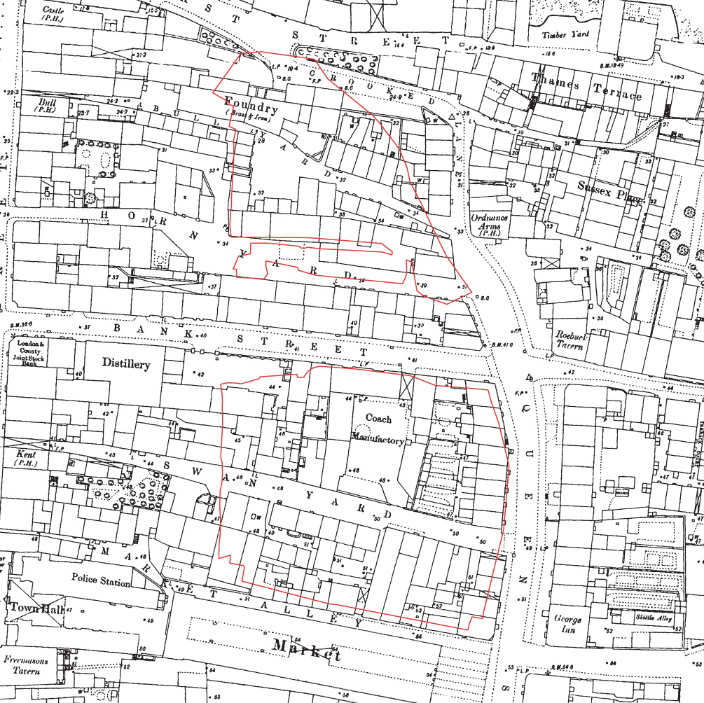
The 1769 Andrews, Dury and Herbert Map of Kent depicts the site as an area of gardens, and provides a terminus post quem for the construction of buildings on the site. Use of the site prior to 1769 was probably low intensity, comprising activities such as gardening and agriculture. An earlier reference to a fire in Horn Yard in 1748 probably refers to the area immediately adjacent to High Street and outside the boundaries of the site. The fire spread to a warehouse containing gunpowder, which exploded (Discover Gravesham 2023c). Produced in 1840, a tithe map depicts the site already substantially developed (Figure 4).

The map shows irregular small-scale development arranged around pedestrian passageways aligned west to east and connecting the north to south aligned High Street and Queen Street. This map is in places more of a sketch than a survey and depicts ambiguous divisions that could be buildings or yards. It is easy to forget the small scale of these passageways when examining maps. Where they connect with High Street, the west ends of most of these passages are preserved today, but they are easily missed, being less prominent than nearby shop doorways. See Market Alley, Swan Yard, Horn Yard, Bull Yard. High Street itself is not broad, and is now a pedestrian route where the passage of motor traffic is difficult to imagine.
The tithe apportionment (Kent Archaeological Society n.d.) has not been a useful aid to interpretation. More useful was the almost contemporary 1841 census, which reveals that domestic occupation of the yards was at about the same intensity as that which continued to be supported throughout the 19th century. Development was therefore substantially complete by the early 1840s. The numbers of households for Bull Yard, Horn Yard, Bank Street, Swan Yard and Market Alley have been tabulated below. Many censuses appear to have failed to capture the population of these yards, perhaps a reflection of a perception of danger, or of insignificance.
| Bull Yard | Horn Yard | Bank Street | Swan Yard | Market Alley | |
|---|---|---|---|---|---|
| 1841 | 21 | 12 | [Not yet constructed] | 12 | 11 |
| 1851 | Not surveyed | Not surveyed | [Not yet constructed] | Not surveyed | 11 |
| 1861 | 20 | 9 | 10 | 16 | 9 |
| 1871 | Not surveyed | Not surveyed | 9 | Not surveyed | Not surveyed |
| 1881 | 16 | 9 | 5 | 16 | 9 |
| 1891 | 14 (plus 4 empty; empty properties not usually recorded) | 11 | 15 | 13 | 12 |
| 1901 | Not surveyed | Not surveyed | 10 | Not surveyed | [Largely demolished] |
| 1911 | Not surveyed | Not surveyed | 10 | Not surveyed | [Largely demolished] |
| 1921 | 18 | 10 | 20 | 10 | [Largely demolished] |
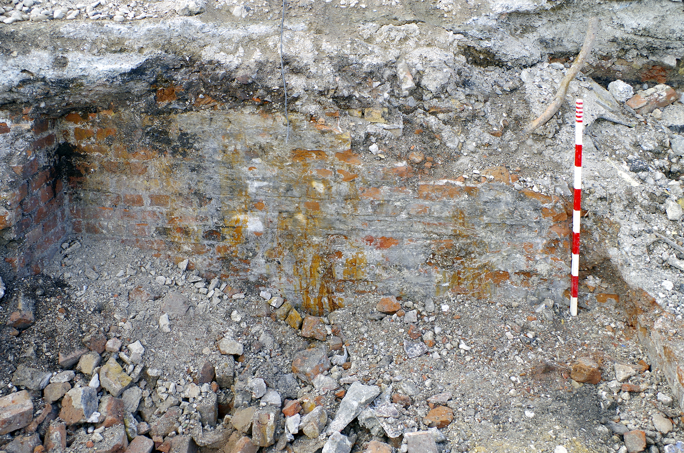
Excluding a small number of later structures dated by the materials used in their construction (machine brick, Portland cement, concrete, stone), most of the remains from the site form a single indivisible phase of activity. This phase is characterised by the use of handmade red bricks, yellow stock bricks and lime mortar (Section 1.7). It spans the period from the earliest development of the site until around the late 19th century. In a few cases, stratigraphic relationships reveal more granular phased development:
Almost all of the structures revealed were brick, the majority bonded with lime mortar. The bricks used were generally handmade, either red or yellow in colour, the latter being 'stock' bricks associated with London, Kent and other nearby counties. Kent was the centre of a brick-making boom that began in the 1820s (after the Napoleonic Wars) with the construction of the London docks and other developments and included later railway construction. Bricks, particularly stock bricks, were produced in various locations in Kent, including Gravesend, using local brickearth clays (Preston 1995 114). All the examples measure 220-240mm in length, 70-100mm in width and 60-70mm in height. These materials were used roughly from the late 18th century until the late 19th century and beyond. Within the context of the site, there is no chronological difference between the red bricks and yellow stock bricks, with both types mixed in some contexts, and with examples of both yellow brick structures post-dating red brick structures and vice versa. The appearance of frogged bricks is early, as is characteristic of the region. These bricks are prominent in many structures correlating with maps from 1840 and 1866.
To avoid repetition, where no further description of structures is given, the structures comprised handmade brick bonded with lime mortar. All surviving structures, whether cellars, foundations, sanitary provision etc. were built in construction cuts through the chalk bedrock.
With only one exception, Bull Yard, Horn Yard, Swan Yard and Market Alley are not mentioned in any consulted trade directory (Pigot and Co. 1824; Gravesend and Milton Directory 1851; Kelly and Co. 1855; 1882; 1891; Kelly's Directories 1903; 1913; Melville and Co. 1858). Newspapers and historic maps demonstrate the presence of a wide range of activities operating from the yards; however, this activity was not captured by the directories. The yards may have been overlooked owing to their dangerous low-status character and small size. Trade directory entries exist for the slightly higher-class Bank Street, Queen Street and Crooked Lane and are integrated in the text below.
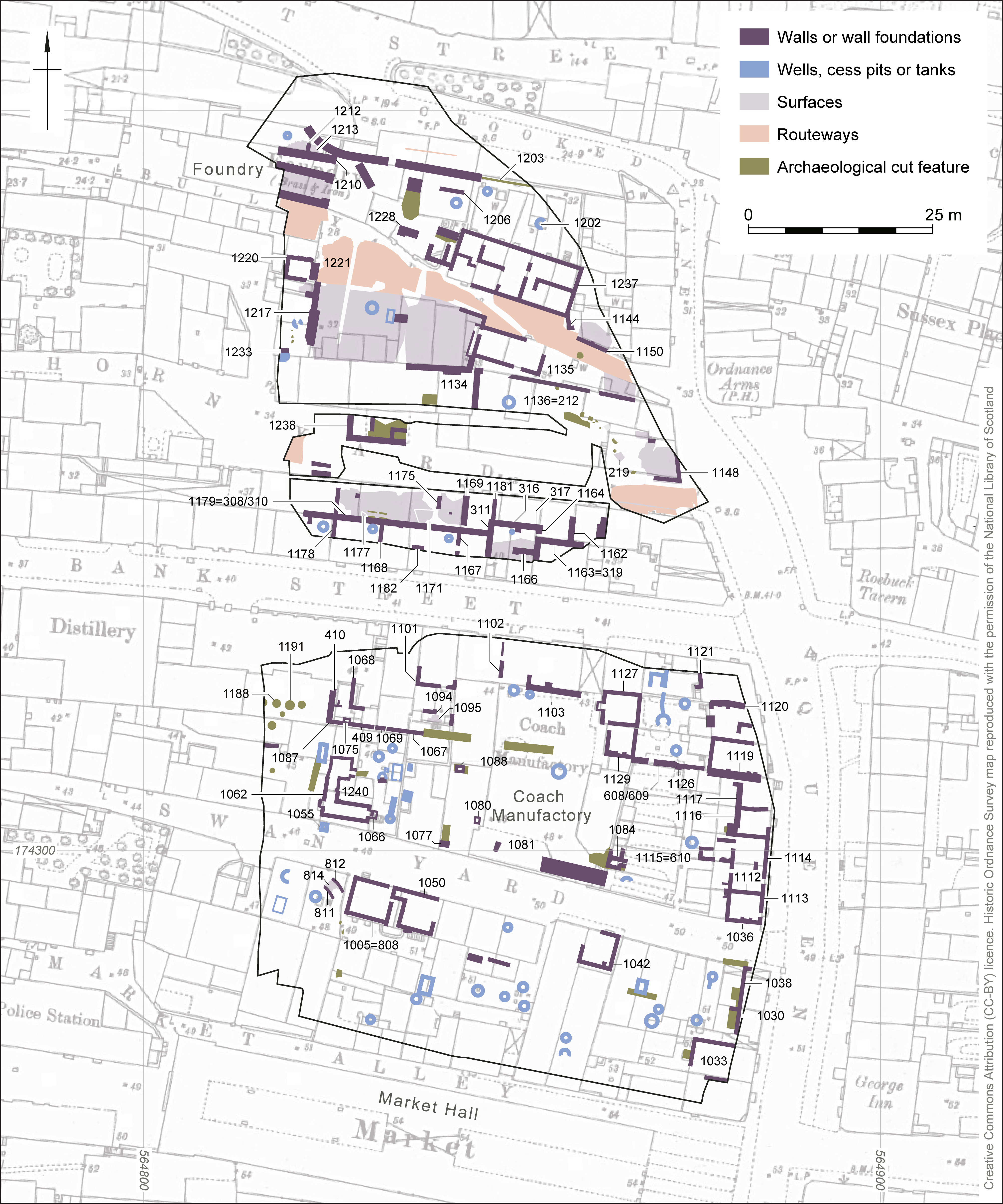
The majority of this article comprises biographies of the different thoroughfares within the site. These can be explored by clicking Figure 6.
Market Alley was a low-status route, dwelling place and site of industrial activity, located adjacent to the former Gravesend Market. The extant market is located immediately south of the site and was opened on 18 December 1898 (Discover Gravesham 2023d). This replaced an earlier building depicted on historic maps, including on the 1840 tithe map (Figure 4). When the new market was opened local newspapers were flooded with complaints about the closure of the public thoroughfare through the market outside of opening hours (e.g. Gravesend and Northfleet Standard, 21 January 1899). Many people would rather have paid a toll to walk through the respectable market than down the adjacent Market Alley for free, which was 'by no means of inviting character' (Section 3) (Gravesend Journal, 20 January 1883). This was despite the alley having been recently resurfaced with paving stones (Gravesend and Dartford Reporter 14 February 1880; Gravesend and Northfleet Standard, 18 February 1899). Nothing survived of these paving stones.
The area of Market Alley was not drawn on the 1840 tithe map (Figure 4), though the 1841 census lists 11 households. It is only in the newspaper archive that we find clues to the economic activity of this alley. 'Starting from High Street, by a passage about a yard wide, we enter what is known as Market Alley. On the right of this passage are the premises of Mr. Barnaschina, upholsterer, and on the left those of Mrs. Coles, the baker. Then we come to a series of buildings, built of wood, used as slaughterhouses, piggeries, warehouses, and common lodging-houses, mixed together in a most extraordinary manner. Some of the houses have scarcely a whole pane of glass in the windows, whilst a peep inside will disclose a state of things which ought not to be permitted to exist in any town, and to which the vagrant ward in any union is a paradise by comparison' (Gravesend and Dartford Reporter, 12 July 1879; Figure 7).
There was no preservation of the remains of buildings at Market Alley. Historic maps are consistent with construction exclusively using wood. However, no postholes, beam slots or other forms of earthfast foundations were identified by excavation. The buildings may have been shallowly founded, rapidly constructed using poor quality techniques, and with all traces completely removed by demolition.
The east end of Market Alley was cleared in the first decade of the 20th century to facilitate access to the Market. 'The Town Hall and Market Committee recommended the Council to purchase of Mr. Gilbert for £1,000 the piece of land having a frontage of about 50 ft. on Market Alley and Swan Yard respectively, with a depth of about 70 ft., as an annex to the market and for storage of stalls and for the provision of an approach for vehicles, so that they can enter by Market Alley, unload at the northern door of the market and return by way of Swan Yard, thus facilitating the setting up of the market by the stall holders and preventing the blocking of Queen Street' (Gravesend and Northfleet Standard, 17 August, 1901). Tenders were invited for the demolition, including the infilling of 'cess pools' (Gravesend and Northfleet Standard, 26 July 1902). The first phase of clearance was complete by the time of the compilation of a 1909 Ordnance Survey map (Figure 8) and had progressed further by 1932 (Figure 9).
Market Alley was absent from the 1901, 1911 and 1921 censuses, probably in part because of the demolition described above. The few buildings that continued to be depicted on maps may have been either unoccupied or may have been non-domestic premises, if they were not simply missed from all three censuses.
Crime was common across the site, as outlined in Table 2.
| Category of crime | Market Alley | Swan Yard | Bank Street | Horn Yard | Bull Yard |
|---|---|---|---|---|---|
| Petty theft | Gravesend Reporter, 22 August 1857; Gravesend Journal, 27 October 1877, 8 July 1882; Gravesend and Dartford Reporter, 8 July 1882; Gravesend and Northfleet Standard, 24 June 1893; The Reporter, 22 August 1896, 2 March 1901 | Gravesend and Dartford Reporter, 9 March 1867, 3 May 1884; The Reporter, 17 September 1898, 26 November 1898, 7 September 1901; Gravesend and Northfleet Standard, 26 August 1899, 14 November 19 | Gravesend Journal, 18 August 1888, 28 February 1891; The Reporter, 28 February 1891 | Gravesend and Dartford Reporter, 7 July 1866, 6 January 1883, 26 January 1884; Gravesend and Northfleet Standard, 2 May 1913 | Gravesend and Dartford Reporter, 19 August 1865, 3 September 1864; Gravesend Journal, 8 July 1882; Gravesend and Northfleet Standard, 19 December 1912, 20 and 27 May 1913 |
| Assault or fighting | Gravesend Reporter, 13 November 1858, 22 May 1880; Gravesend Journal 22 May 1880, 3 December 1881, 30 June 1888; The Reporter, 7 December 1895, 23 September 1899, 29 December 1900 | The Reporter, 25 December 1897 | Gravesend Journal, January 26 1878; Gravesend and Northfleet Standard, 22 March 1907 (assault with acid) | The Reporter, 25 June, 1892, 4 August 1906; 15 September 1906, Gravesend and Northfleet Standard, 6 September 1912 | Gravesend and Dartford Reporter, 19 June 1875, 23 September 1899; Gravesend and Northfleet Standard, 19 May 1900, 16 and 18 August 1907, 23 June 1914; The Reporter, 24 June 1905 |
| Drunk and disorderly | Gravesend and Dartford Reporter, 6 October 1866, 13 August 1870, 15 July 1876, 28 January 1888, 4 October 1884; Gravesend Journal, 13 August 1881; 24 September 1881, 30 April 1892; The Reporter, 4 February 1893, 7 April 1894, 1 August 1896, 15 June 1901; Gravesend and Northfleet Standard, 16 September 1893, 15 June 1901 | Gravesend Reporter, 9 May 1863, 12 March 1864; Gravesend and Dartford Reporter, 4 August 1866, 24 August 1867, 19 July 1884; Gravesend Journal, 12 March 1881; 22 September 1883; The Reporter, 10 April 1897, 3 June 1899, 20 February 1904, 12 December 1906; Gravesend and Northfleet Standard, 3 June 1899, 24 August 1901, 31 May 1912 | Gravesend Journal, 18 August 1888; The Reporter, 21 October 1893, 4 December; Gravesend and Northfleet Standard, 26 September 1903 | The Reporter, 31 October 1908 | Gravesend Journal, 13 February 1892, 1 September 1888; The Reporter, 17 August 1901; Gravesend and Northfleet Standard, 5 July 1912 |
| Obscene or provoking language | The Gravesend Reporter, 1 September 1860; Gravesend and Dartford Reporter, 6 December 1879; The Reporter, 8 August 1896 | Gravesend Journal, 22 September 1883; The Reporter, 7 September 1901, 20 May 1905; 19 August 1905, 12 December 1906, 22 August 1908; Gravesend and Northfleet Standard, 16 February 1915 | Gravesend and Northfleet Standard, 16 January 1897 | The Reporter, 3 June 1899; Gravesend and Northfleet Standard, 3 June 1899, 6 August 1915 | Gravesend and Dartford Reporter, 13 January 1866, 24 August 1867; Gravesend and Northfleet Standard, 2 June 1900; The Reporter, 24 June 1905 |
| Indecent or improper conduct (i.e. sex work), indecent assault | Gravesend Journal, 11 June 1881; The Reporter, 7 April 1894 | Gravesend and Dartford Reporter, 24 April 1880; The Reporter, 27 April 1895 | |||
| Domestic abuse (inc. suicide attempts) | Gravesend and Dartford Reporter, 2 October 1880, 28 October 1882; The Reporter, 15 May 1897, Gravesend Reporter 17 June 1899 | ||||
| Child neglect (inc. leading to death) and maintenance arrears | Gravesend and Northfleet Standard 15 June 1901; The Reporter, 15 June 1901 | The Reporter, 22 July 1893, 22 December 1906; The Reporter, 27 February 1909 | The Reporter, 23 July 1898, 5 February 1898 | The Reporter, 3 October 1908; 16 January 1909 | |
| Murder and manslaughter | Gravesend and Dartford Reporter, 3 December 1864 | The Reporter, 2 September 1905 (the manslaughter occurring on Crooked Lane) | |||
| Other | Allowing a deposit of offal and blood to remain in a dung heap (Gravesend and Dartford Reporter, 11 August 1866); Unlawfully and cruelly ill-treating, abusing and torturing a bullock (The Reporter, 11 September 1897) | Failing to give notice of foot and mouth disease (Gravesend Journal, 16 January 1875); Groups of children causing an obstruction (The Reporter, 12 March 1904) | Selling eels without paying Market fee (Gravesend and Northfleet Standard, 6 September 1902) |
A curious tale and a rare reference to the recreational use of drugs was that of William Morgan of Market Alley, who was found in Crooked Lane (forming the northern boundary of the site). The police, doctor, court and newspaper struggled to conceive that he had not been drinking alcohol. By his own account he had instead drunk a drachm and a half of chloral. He justified causing £1 of damage in the police cells, including destroying a toilet, by explaining 'I resisted because they wanted to put me under the process of animal magnetism to absorb my brain into the idiotic son of Jackson' (Gravesend Journal, 1 September 1888).
Two cases of the killing of non-infants were identified. A man named Hull fatally stabbed a young boy, William Archer of Market Alley, with a red-hot steel as the two of them worked at an anvil at the works of Messrs Bell and Jacobs. The boy had dropped his hammer (Gravesend and Dartford Reporter, 3 December 1864). The manslaughter of Matthew Page was caused by punches and perhaps kicks inflicted at 6 Crooked Lane following sexual advances towards married women there and in Bull Yard. Around half a crown (2s 6d) had changed hands (The Reporter, 2 September 1905). The newspaper report is bowdlerized, but this may be evidence of sex work, with the deceased mistaking the identity of a woman.
Further evidence of sex work was an assault on a woman in Bank Street after a soldier had paid her a shilling to go home with her; after taking the shilling she refused (Gravesend Journal, January 26 1878). Another example is that of Harriet Annie Witts, one time of Market Alley, who had 'been getting her living by improper means'. She had twice abandoned her neglected child and was also sentenced for the theft of field glasses (binoculars; Gravesend Reporter, 17 June 1899; Northfleet and Swanscombe Standard. 3 February 1900; Gravesend and Northfleet Standard, 24 September 1904).
In 1883 an unnamed boy from Market Alley was the victim of crime when he was kicked in the leg by Major Frank Smith of the Salvation Army. Smith defended himself farcically before magistrates and was fined 5s and 14s 6d costs, which was 'settled by a local gentleman'. The circumstances of this act were the Salvationists 'assault' on the town, which was met by a 300-400 strong 'Skeleton Army' of the 'Sons of Neptune' carrying a black banner of a full length skeleton and including a band equipped with instruments such as foghorns. The Salvation Army were outnumbered around ten to one and were pelted with rotten eggs after they had marched down Queen Street to West Street. A variety of other incidents occurred, including an aborted attempt to burn down the Temperance Hotel, which the Salvationists had made their barracks, by rolling a lit tar barrel down the hill (Gravesend and Dartford Reporter, 20 October 1883).
Another issue within the slum was that of sanitary provision. The newspaper description of Market Alley continued: 'Within a few feet of some of the houses pigs are constantly kept, and other animals are slaughtered daily, whilst the general squalor and want of sanitary arrangements in the whole is at any time sufficient to account for the outbreak of any epidemic.' The neighbouring Swan Yard fared little better. 'Dung heaps abound in this locality, some of them being within a few feet of the doors of dwelling-houses, and here also squalor, filth, and general neglect of all sanitary precautions seem to invite fevers and other dangerous diseases. … and thus, in the very heart of the borough, every preparation is made for the incubation and fostering of those diseases which it should be the duty and purpose of the urban sanitary authority to use every endeavour to prevent' (Gravesend and Dartford Reporter, 12 July 1879; Figure 7).
The only masonry remains (Section 1.7) in the area of Market Alley were those of sanitary provision and water supply, primarily in the form of cesspits and wells. The remains of sanitary features and wells continued across the entire site, although they were most plentiful in the south in the area of Market Alley.
An early reference to sanitary provision in Market Alley was a complaint by the town surveyor that the gully belonging to the commissioners had been 'enclosed by some parties who had built there, so that it could not be got at (Gravesend Journal, 7 December 1864). This reveals not only the inadequate sanitation at this date, but also that development was not controlled.
There are some references to instances of disease caused by poor sanitation within the passageways. Letters from residents and a doctor complained about the state of the drains in Market Alley, which had caused fever in the family of Mr Barnaschina (Gravesend Journal, 13 May 1876). Sanitary provision in Bull Yard was lacking, with a shallow privy suspected of being the cause of a serious case of erysiplas (a skin complaint; Gravesend Journal, 31 May 1890).
By the late 19th century, improvements were being made to sanitation, with a push in 1886 to fill in privy pits in courts and alleys (Discover Gravesham 2023e). It is uncertain to what degree the 1886 infilling was carried on within the uninviting passageways.
Earlier than 1896, sewage was being removed by vans, which were built at the coach manufactory of Robert Gates on Bank Street (The Reporter, 8 February 1896).
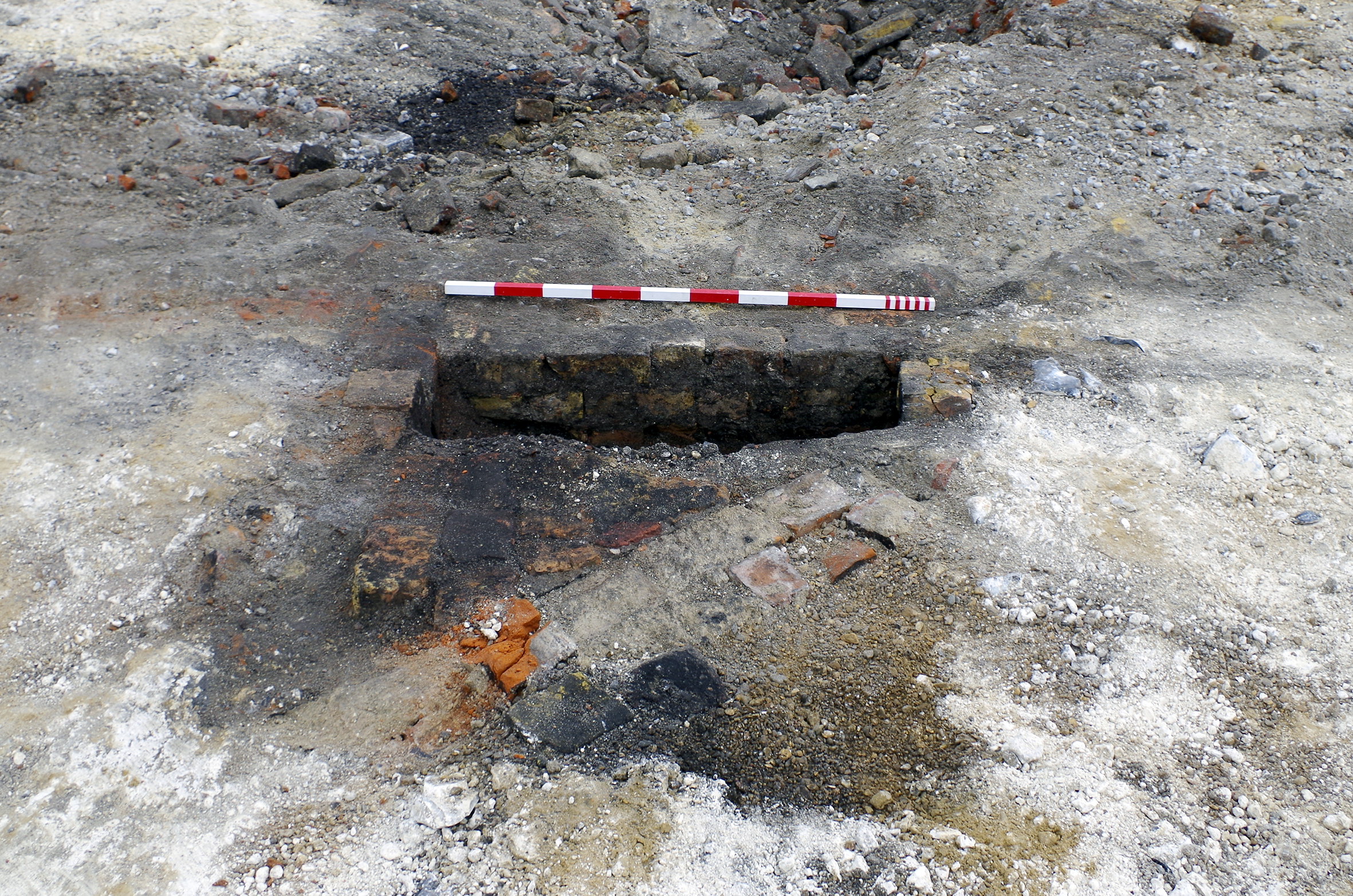
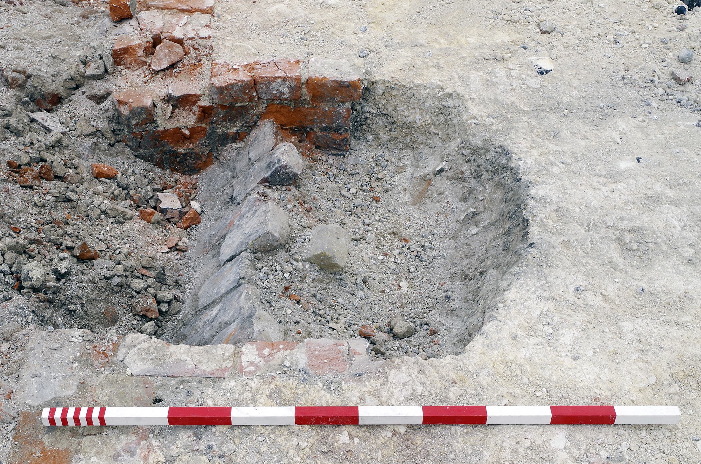
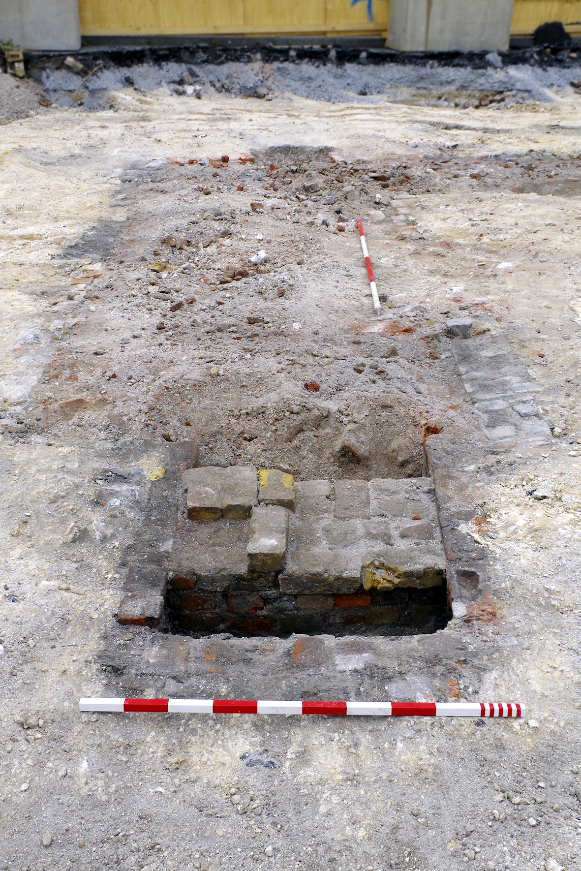
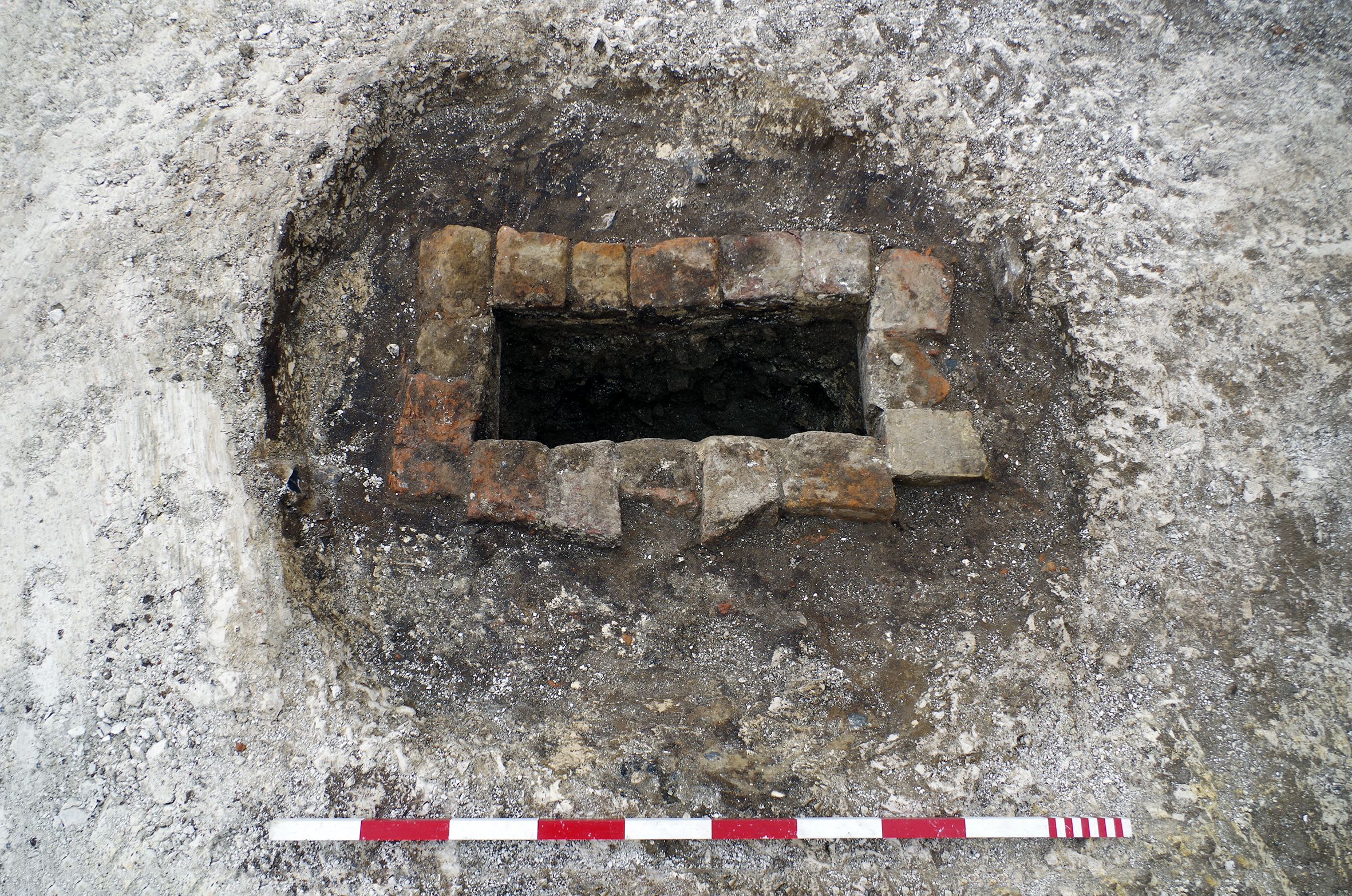
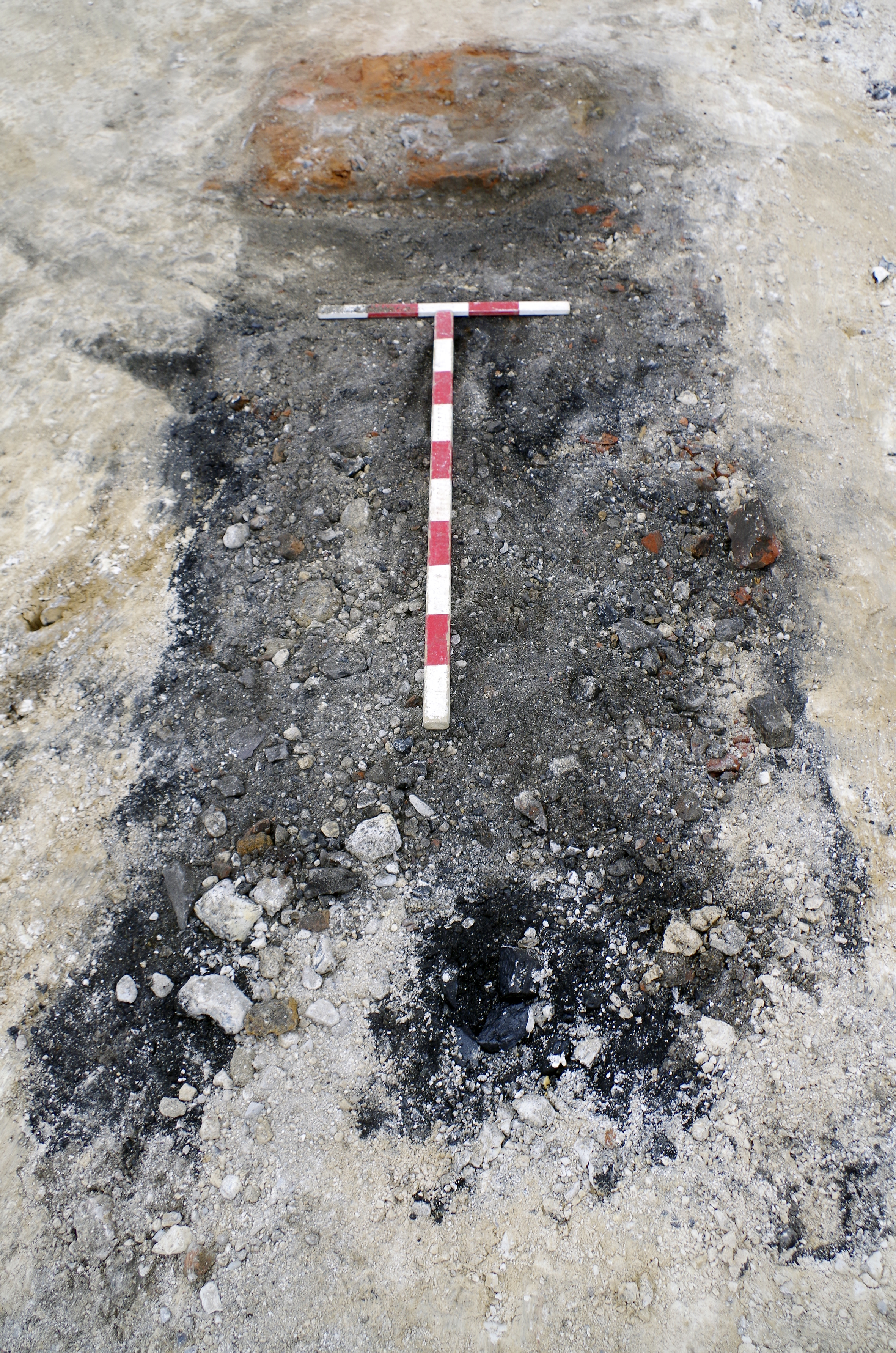
Excavation revealed some 39 similar circular features (as well as up to eleven rectangular examples) across the site, mostly lined with one or two skins of red and/or yellow brick (Figures 10-13).
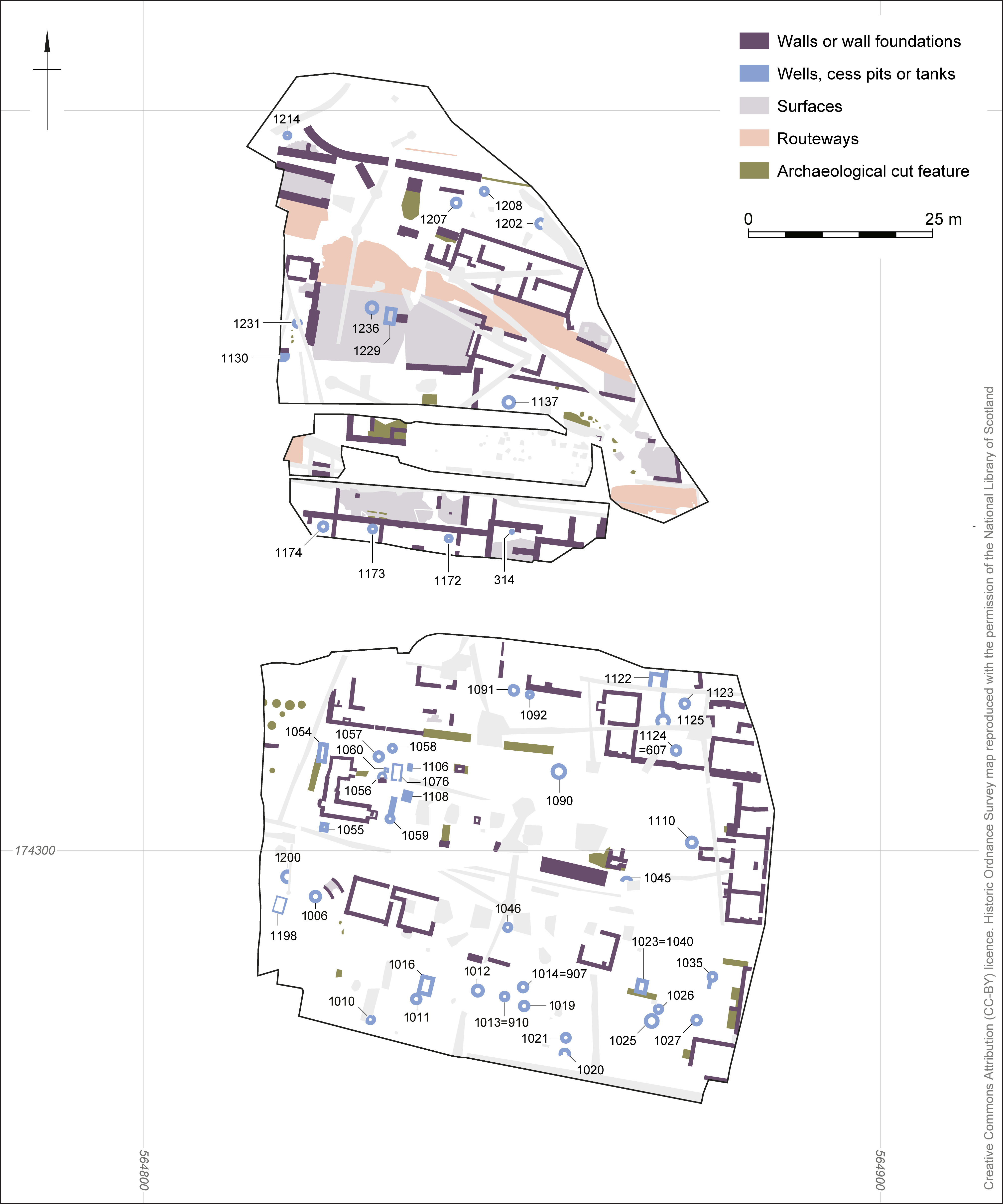

Some can be definitively identified as cesspits, either because of the presence of ceramic pipes or brick drains feeding into them, or by their location correlating with mapped privies. Others, such as those contained within the cellars of houses north of Bank Street, were probably wells. These features were all morphologically similar, with only minor differences in materials and form. The function of many of the features cannot therefore be differentiated. Some of the potential wells were located close to cesspits, which would have posed a high risk of contamination.
Some of the cesspits/wells were backfilled with poured concrete. This probably indicates nothing more than that these examples were revealed during demolition or redevelopment in the 20th century and contained voids that were backfilled at that time.
| Feature number | Lining | Interpretation | Diameter (m) |
|---|---|---|---|
| 314 | Red brick | Cesspit/well | 1.0 |
| 1006 | Red brick headers | Correlated with a well mapped in 1866; however, a ceramic pipe discharging into the feature reveals it to have been a cesspit. It is possible the mapmaker misidentified the feature, particularly if it were disused. Alternatively it might have been a well converted into a cesspit. | 1.6 |
| 1010 | Curved red radius bricks | Cesspit; correlated with privy depicted on 1866 map | 1.2 |
| 1011 | Repaired in late 19th or early 20th centuries with a single machine brick and lime mortar. | Cesspit; correlated with privy depicted on 1866 map | 1.3 |
| 1012 | Red brick | Cesspit/well | 1.4 |
| 1013=910 | Red brick | Cesspit/well | 1.2 |
| 1014=907 | Yellow brick | Cesspit/well | 1.4 |
| 1019 | Yellow brick, one side modified in late 19th or early 20th centuries to be squared off with red machine bricks and lime mortar. | Cesspit; correlated with privy depicted on 1866 map | 1.3 |
| 1020 | Yellow brick | Cesspit/well | 1.5 |
| 1021 | Red and yellow brick | Cesspit/well | 1.31 |
| 1025 | Yellow brick | Cesspit; correlates with small building, probably a privy, depicted on 1866 map | 1.8 |
| 1026 | Red brick | Cesspit/well | 1.2 |
| 1027 | Yellow brick | Figure 11. Cesspit; correlates with small building, probably a privy, depicted on 1866 map | 1.25 |
| 1035 | Red brick | Cesspit; ceramic pipe leading into feature | 1.21 |
| 1045 | Yellow brick | Cesspit; correlates with privy depicted on 1866 map | Unmeasurable |
| 1046 | Red brick | Cesspit/well | 1.14 |
| 1056 | Generally not revealed/unlined, but south side squared off with red brick. | Cesspit/well | 1.32 |
| 1057 | Red and yellow brick | Cesspit/well | 1.3 |
| 1058 | Not revealed/unlined | Cesspit/well | 0.8 |
| 1059 | Red and yellow brick | Cesspit; brick drain leading into feature | 1.2 |
| 1090 | Red and yellow brick | Cesspit; bottle-shaped profile | 1.7 |
| 1091 | Red brick | Cesspit/well | 1.1 |
| 1092 | Red brick | Cesspit/well | 1.0 |
| 1110 | Not revealed/unlined | Cesspit/well; probably pre-dates mapped scullery of house depicted on 1840 map | 1.2 |
| 1123 | Red brick traces | Cesspit/well | 1.2 × 1.0 (oval) |
| 1124=607 | Red brick traces | Cesspit/well | 1.5 |
| 1125 | Yellow brick | Cesspit; ceramic pipe leading into feature | 1.5 |
| 1130 | Not revealed/unlined | Cesspit/well | 1.2 |
| 1137 | Not revealed/unlined | Cesspit/well | 1.28 |
| 1172 | Red and yellow brick | Well; regular layout within house cellar | 1.3 |
| 1173 | Red and yellow brick | Well; regular layout within house cellar | 1.3 |
| 1174 | Red and yellow brick | Figure 12. Well; regular layout within house cellar | 1.3 |
| 1200 | Red bricks | Cesspit/well | 1.0 |
| 1202 | Red brick | Cesspit; correlates with privy depicted on 1866 map | 1.2 |
| 1207 | Yellow brick | Cesspit/well | 1.2 |
| 1208 | Not revealed/unlined | Cesspit/well | 0.9 |
| 1214 | Not revealed/unlined | Well; located within a medium-sized building | 1.06 |
| 1231 | Not revealed/unlined | Cesspit/well, pre-dates building 1217 | 1 |
| 1236 | Red and yellow brick | Well? Central to open square | 1 |
The diameter of the cesspits and wells ranged from 0.8m to 1.8m, with a mean of 1.24m and a similar median of 1.2m. Of those 11 examples that were positively identifiable as cesspits, the average diameters were higher, with a mean of 1.39m and a median of 1.3m. Only five features were positively identified as wells, with three of them (1172-1174) of identical form and from contemporary adjacent houses, making any statistical analysis meaningless. It is possible that cesspits were typically larger than wells, but there were examples of each type from both ends of the range.
Those features lined with only red brick were on average roughly the same diameter as the whole sample set (mean 1.16m; median 1.2m). However, those eight features lined with yellow brick were larger (mean 1.42m; median 1.4m). It is possible that this correlation reflects a chronological trend; however, the sample size here is not large enough to draw firm conclusions.
The diameters of the three or four stratigraphically early cesspits/wells (1110, 1202, 1231 and maybe 1208, see above) were not unusual.
There were also up to eleven rectangular brick tanks or inspection chambers (1016, 1023=1040, 1054, 1055, 1060, 1076, 1122, 1198, 1229, and potentially truncated cuts 1106 and 1108; Figure 13). These were often located close to cesspits/wells and may have been associated with sanitary provision. It may be that some of these were cesspits of rectangular form, and some perhaps baffle tanks to separate solids from liquids. They were generally lined with one or two skin walls of red brick (and, in the case of 1023=1040 and 1060, also yellow bricks). They were a maximum of 2.1m long. A four-skin red brick structure (1230) ran up to tank 1229 and might have been the base of a drain connecting with the tank, if it were not a wall.
Swan Yard was another small thoroughfare, similar to Market Alley located immediately to the south. Domestic abuse and child neglect (Section 3) appear to have been a speciality of Swan Yard. The newspaper reports contain very serious allegations of physical harm leading to at least two attempted suicides of women as well as the deaths of children. These included a two-day old girl who had 6½ inches (0.16m) of very thick thread in her stomach (Gravesend and Dartford Reporter, 2 October 1880; The Reporter, 15 May 1897; 22 July 1893; 27 February 1909).
Chimney sweeps were another speciality of the yard. 'Go a little lower down High Street and pass from thence to Queen Street by way of Swan Yard. The most imposing dwellings in this yard are the homes of sweeps, one of whom claims, by his sign, the high title of “Chimney Sweep to Her Majesty”' (Gravesend and Dartford Reporter, 12 July 1879; Figure 7). The firm of Prisley Chimney Sweeps traces its origins to Benjamin Prisley of Swan Yard (Prisley Chimney Sweeps n.d.). The 1841 census records Thomas Priestly [sic], chimney sweep of Swan Yard. These references appear to represent a single individual, Thomas Benjamin Prisley, who died in 1856. The 1841 census recorded two young boys in the household of Thomas Priestly who were also sweeps (Charles Aldrige, 14, and William Aldridge, 9). In 1875 the contents of 6 and 7 Swan Yard were auctioned off comprising 'a strong black cob, cart, van and two sets of harnesses, about 800 bushels of soot [perhaps 7 or 8 tons], two sweeping machines, and about 300 sacks, pig, rabbits, hutches, patent chaff box, and cart setter, capital mangle and numerous other effects' (Gravesend and Dartford Reporter, 2 January 1875). These were evidently the effects of chimney sweeps. Another chimney sweep in the yard was Mr Clark of 8 Swan Yard (Gravesend and Dartford Reporter, 1 November 1884).
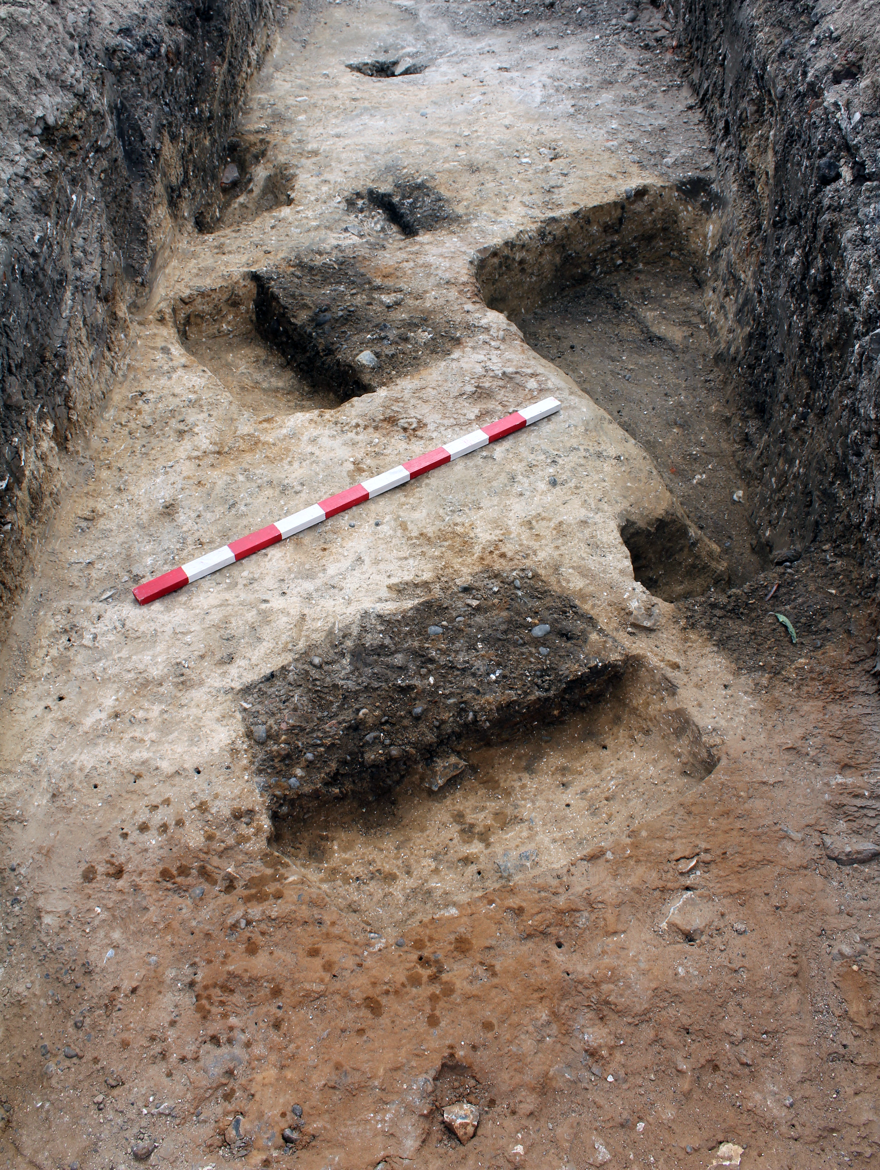
In addition to a coach factory (Section 7), there were at least four brick buildings (Section 1.7) on Swan Yard within the boundaries of the site. The remains of their cellars (808=1005, 1050, 1042 and 1240) were revealed. These correspond closely with houses mapped in 1866 (Figure 5), and probably present in 1840, although the quality of the mapping was less good in 1840 (Figure 4). Other rectangles shown on the maps probably depicted a mixture of wooden buildings and gardens or yards such as those used as piggeries.
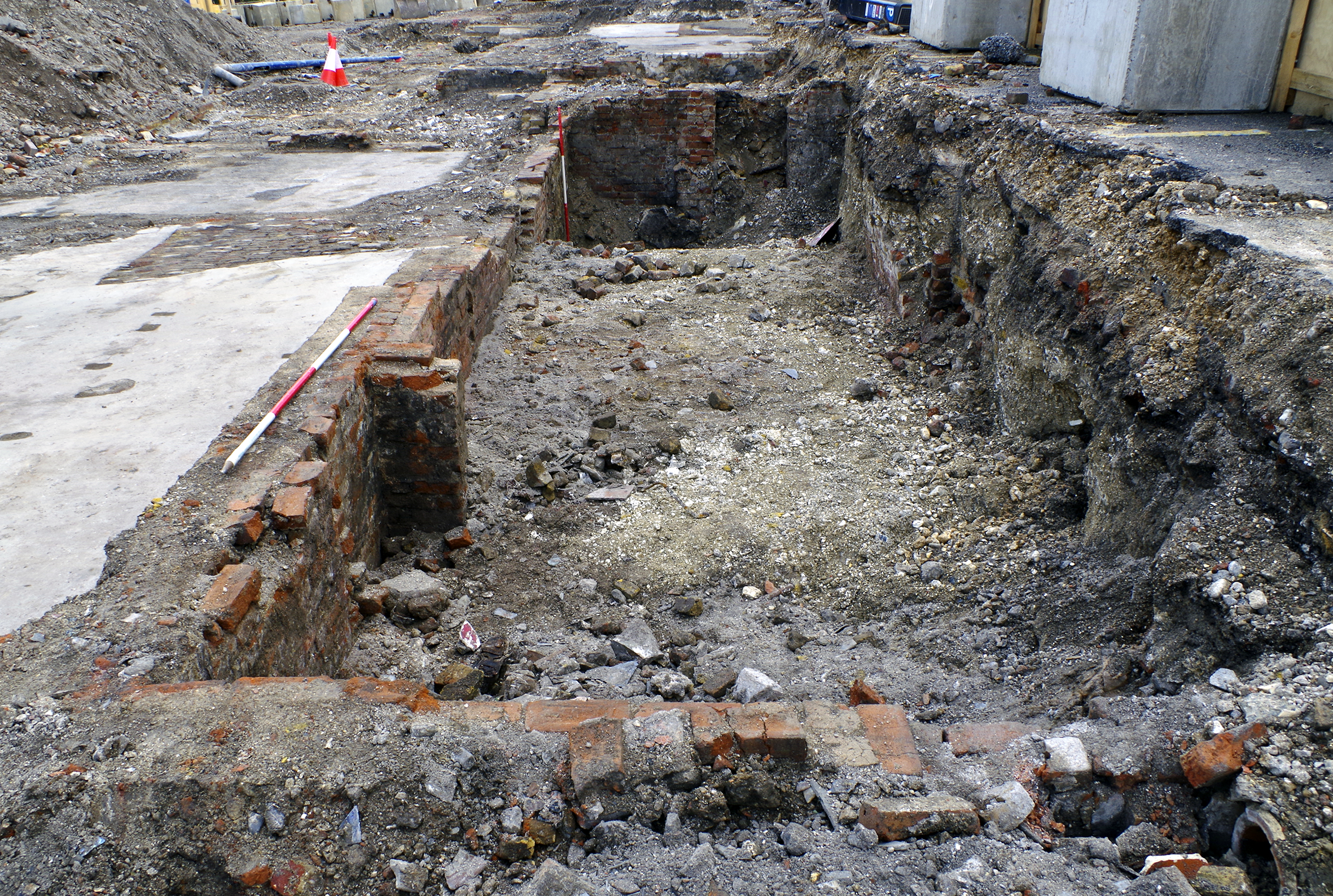
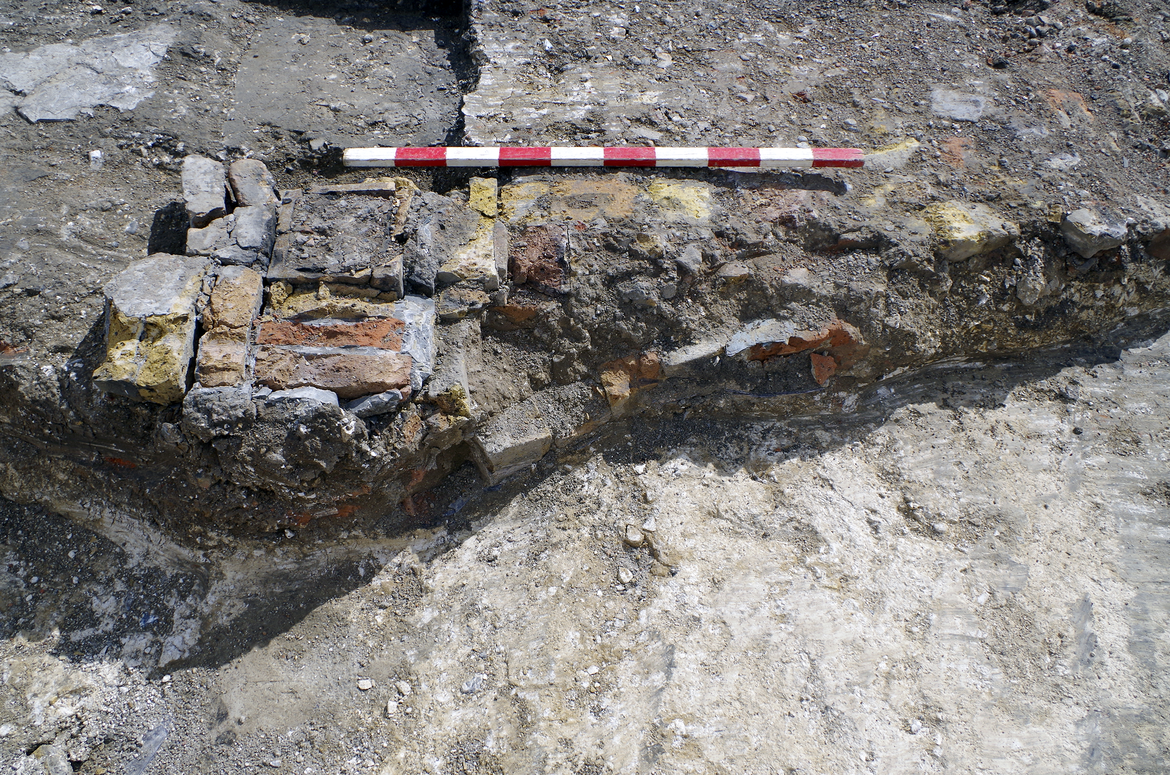
The cellars on the south side of Swan Yard included two of red brick that were adjacent (1005=808 and 1050; Figures 14 and 15). Unusually, both cellars had been lined with rough-poured concrete. This modification probably took place in the early 20th century and might have been a response to damp. An opening from cellar 1005 north to Swan Yard was revealed, probably a coal chute. A staircase (Figure 15) led from cellar 1050 to a rear yard, incorporating a 90° turn. The treads of the staircase had been removed, revealing the red brick risers. This staircase had been inexpertly blocked with yellow bricks, presumably around the same time the concrete lining was installed, if not after. These buildings survived the initial clearance for the expansion of the market and are visible on the 1909 Ordnance Survey map (Figure 8). However, they had gone by the time of the 1932 map (Figure 9).
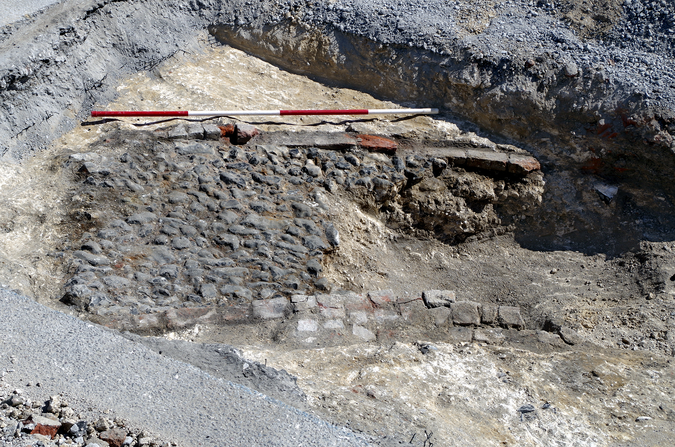
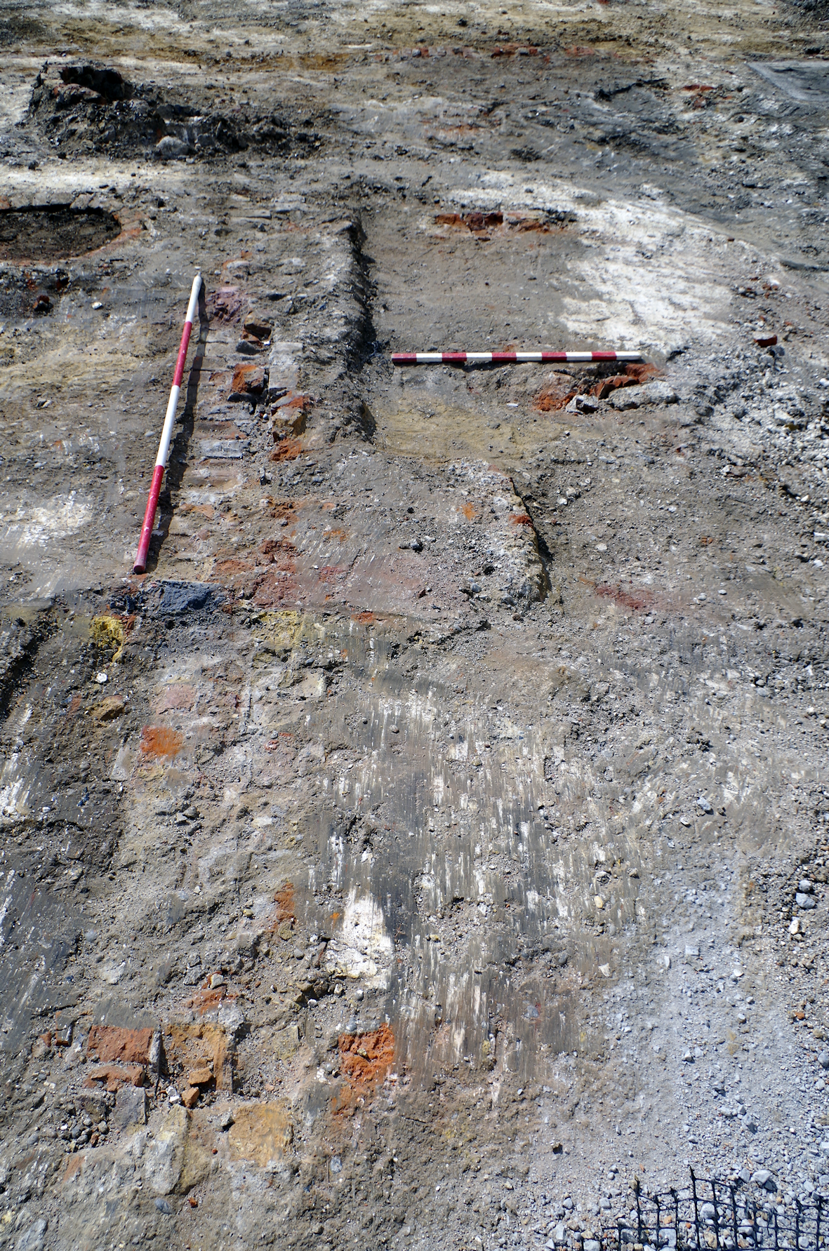
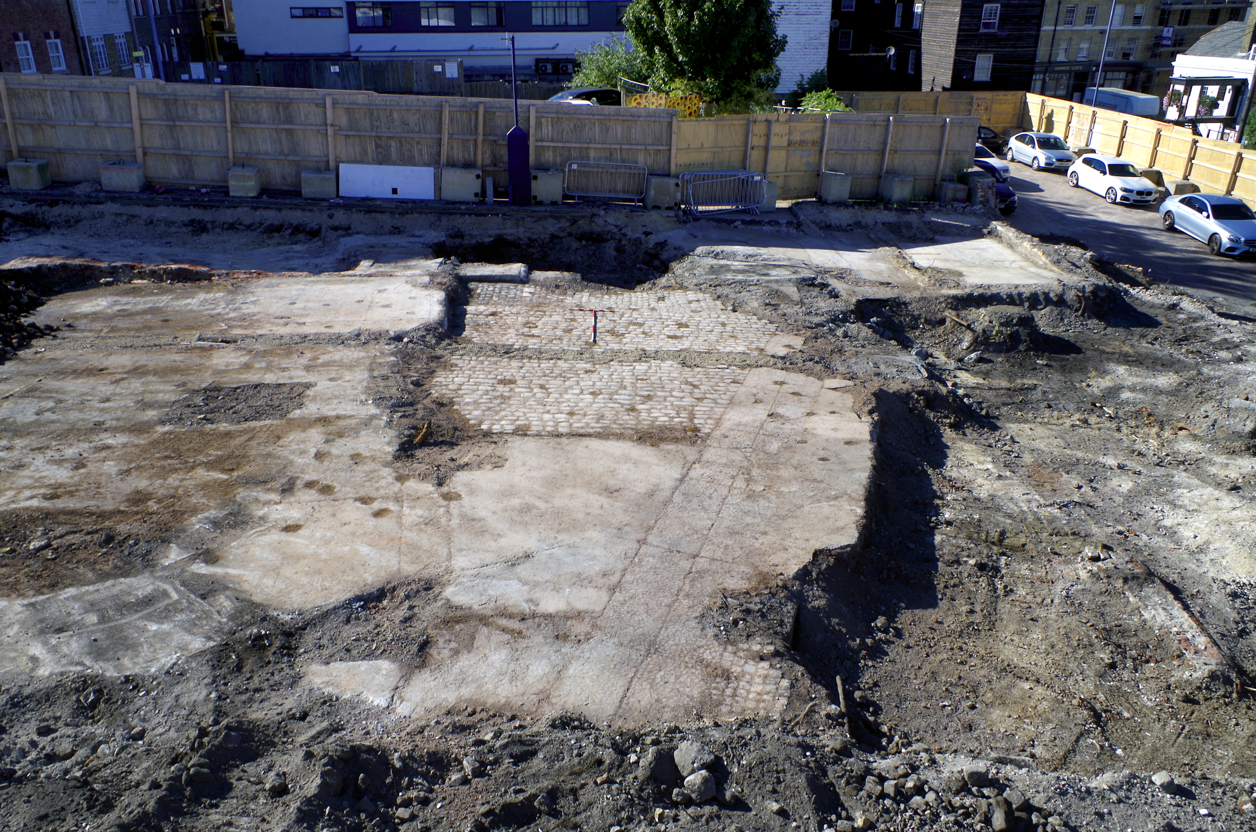
Immediately west of cellar 1005, a fragment of a curving trackway was preserved, comprising a cobblestone surface (814) bordered by red brick walls (811 and 812; Figure 16). This trackway does not correlate directly with consulted historic maps but probably provided access to a small rear yard mapped in 1866 (Figure 5).
Further east was the third cellar (1042; Figure 17), comprising red and yellow bricks. It had been plastered on the inside. A small interior spur wall in the south-east corner might represent the location of a staircase or the foundation of a ground floor passageway leading to the rear yard. This house was cleared during the expansion of the market (Section 2 - expansion of the market), between 1909 (Figure 8) and 1932 (Figure 9).
North of Swan Yard was another series of brick cellar walls (1240), relating to a small courtyard that was perhaps depicted as early as 1840 (Figure 4) and survived until at least 1933 when it appeared on an aerial photograph supplied by Tom Baines (pers. comm.; not reproducible). The photograph shows mostly single-storey brick buildings, with a two-storey building with chimneys to the east of the courtyard. West of the courtyard, cellar walls of plastered red and yellow bricks (1240; Figure 18) were revealed by excavation.
A coal chute (part of 1062, Figure 19) was present in the west of this cellar, accessible from an offshoot of Swan Yard (Figure 5).
A staircase (1066; Figure 20) led east from the cellar into the courtyard. It was bricked up, suggesting that the cellar went out of use prior to demolition. Cesspits/wells 1056-1059, and tanks 1060 and 1076 were present in the yard (Figure 10) (Section 4).
In addition to dwellings, newspaper records mention a variety of buildings in the 19th-century Swan Yard, although some of these may have been located west of the site boundary. These included a coach-house, stables, carpenter's shop, several slaughterhouses, warehouse or store, piggeries, lofts and cart shed (Gravesend and Dartford Reporter, 20 October 1866; 8 April 1871; 6 March 1880; Gravesend Journal, 5 May 1877; Gravesend and Northfleet Standard, 10 June 1892). The stables were at least in part used for cows. John Gason was charged with neglecting to give notice of cattle suffering with foot and mouth disease at stables in Swan Yard (Gravesend Journal, 16 January 1875).
As early as 1895, plans were in motion for the construction of a Fire Station and Mortuary in Swan Yard (Gravesend and Northfleet Standard, 30 November 1895; Northfleet and Swanscombe Standard, 13 February 1897), which had been constructed by the time of the 1909 map (Figure 8). This redevelopment affected a small part of the west of the site, where an open yard or piggery containing a well was converted to part of the yard of the Fire Station/Mortuary. The well (1006, Figure 10) was identified during excavation but appeared to have been used as a cesspit because a drain fed into it.
Swan Yard was resurfaced with flints and granite in a 3:1 proportion in 1894 (Gravesend and Northfleet Standard, 3 March 1894), but no solid surface was revealed by excavation. A drain inspection chamber constructed from handmade yellow bricks (1055) was present within the former alignment of Swan Yard.
In Swan Yard were 'common lodging-houses, stables, piggeries, and tumble-down wooden dwellings, which seem to be awaiting the breaking out of some conflagration as that which occurred in 1844, to have a clean sweep-out' (Gravesend and Dartford Reporter, 12 July 1879; Figure 7). The disastrous fire of 1844 caused between £10,000 and £15,000 of damage in Gravesend but did not reach the area of the site (Dover Kent Archives 2021; Illustrated London News, 8 June 1844). However, the wooden buildings of Swan Yard and Market Alley would not escape conflagration.
Six fires have been identified from newspaper reports in Swan Yard and Market Alley. The earliest in Swan Yard was caused by fireworks (Gravesend Reporter, 15 November 1856).
A few decades later, a second fire was the cause of great excitement, with the mayor and a large crowd in attendance. The fire started in a warehouse full of new hay and spread to one of two adjacent slaughterhouses. '…so terrified did the poor people become lest their houses, which are chiefly built of wood, should take fire, that they set to work and removed their furniture into the Market Place. The scene was a most distressing one, women and little children, poorly clad, running in all directions burdened with some of the contents of their households' (Gravesend and Dartford Reporter, 20 September 1884). The burnt-out slaughterhouse plot was being offered for development eight years later: 'A PIECE OF BUILDING LAND, enclosed with Brick Wall, in Market Alley, the site on which the slaughterhouse used by the late Mr. Whiddett formerly stood' (Gravesend and Northfleet Standard, 10 June 1892).
Subsequent fires in 1884 drew less excitement. One was in a shed belonging to Mr A.W. Clark of 8 Swan Yard, who was a chimney sweep (Section 5 - chimney sweeps) (Gravesend and Dartford Reporter, 1 November 1884). A third fire in the same year was at the premises of Mr Barnaschina, upholsterer (Gravesend and Dartford Reporter, 13 December 1884). Two years later, a fire at the wooden lodging house at 12 Market Alley was brought under control by the heroic actions of a police officer. When awarded two guineas by the Royal Society for the Protection of Life, Chief Constable Berry was said to have saved 32 lives, although contemporary reports suggest that 17 or 18 occupants had escaped by themselves, into a strong westerly wind and heavy downpour (Gravesend and Dartford Reporter, 3 April 1886 and 14 August 1886). No contemporary suggestion of arson has been identified; however, the physical and temporal proximity of these events does appear suspicious.
More than a decade later sacks were found alight in a van within a stable (The Reporter, 18 March 1899).
These reports of fire reveal that some landlords were absent in London, including that of Mr Whiddett's slaughterhouse and the landlord of 12 Market Alley.
Bank Street was not established until after another disastrous fire (see Section 5.1), this one in 1850, the street then being named after the bank on the corner with the High Street (Discover Gravesham 2023f). However, a passageway on roughly the same alignment was depicted on the earlier 1840 tithe map (labelled 730, Figure 4). This passage led east from the High Street, but any route onwards to Queen Street may have continued only across open ground. The name of this passageway could not be identified in any consulted source.
The construction of Bank Street in the 1850s explains its absence from the Gravesend and Milton Directory of 1851 and Kelly's Post Office Directory of 1855. The earliest identified reference to Bank Street was an advertisement for a bakery on 3 January 1857 (Gravesend Reporter). Construction appears to have been completed by 1858 when the street appeared in the Melville Directory.
Bank Street supported a mix of shops, dwellings and factories. Most notable in the 19th century was a coach manufactory (Section 7). At various times there was also a distillery (outside the site boundaries), a wine and spirit merchant, baker, tobacconist, carpenter, stay manufacturer, earthenware dealer, tailor, fruiterer, dress maker, scale maker, fried fish shop, mineral water factory, laundry, mangling and wringing machine works, ironmongery stores and a builder's yard. The composition of shops changed over the course of the 19th century, and many would have been located outside the site boundaries. In the first decade of the 20th century, the Gravesend Town Band Club and Institute was located on Bank Street. With the exception of the coach factory, it has not been possible to correlate any of these shops and manufactories with remains revealed by excavation.
The 1866 map (Figure 5) shows an enclosed yard south of Bank Street surrounded by rectangular buildings, these extending to the west of the site. The yard approximately correlates with the east end of the unnamed passageway depicted on the 1840 tithe map, and some of the revealed features may date from this time.
Within the building at the rear of this yard was a series of at least four pits (including 1188 and 1191; Figure 21), with further pits perhaps continuing beyond the limit of excavation to the west. These pits contained small rectangular red and yellow brick structures (0.8 × 0.44m in plan), bedded on compacted chalk. The materials suggest that the pits and associated structures were broadly contemporary with the main phase of development. The function of the structures is uncertain. They may have been large postholes, perhaps holding timbers supporting the building, or a floor or gallery within it.
A cellar and foundations correlating with some of the smaller buildings shown in 1866 to the south-east of the yard comprised red and yellow brick walls plastered internally (409, 410, 1067 and 1068; Figure 5). A small (1m long) rectangular structure (1075) of unknown purpose and constructed of yellow bricks was located within the cellar, and a red brick relieving arch (1069) was also present in the southern wall.
The yard was still present in modified form on the 1932 Ordnance Survey map (Figure 9), but by 1955 (Figure 22) had been redeveloped. A 'Foundry (Iron and Brass)' lay immediately west of the site, with an open yard east of the foundry. No remains of the foundry were identified.
North of Bank Street were houses that had almost certainly been constructed in the late 1850s at the same time as the road, replacing different buildings depicted on the 1840 tithe map. Aerial photography (see Historic England; Tom Baines pers. comm.) shows a palimpsest of architectural detailing, suggesting that each house was built or designed semi-independently. Within the site boundaries the houses were three storeys high with a mixture of roof styles. Further west were two-storey flat-roofed commercial premises, the façade of at least one of which still survives incorporated into a larger recent development. The frontage of the Bank Street properties lay outside the site boundary; however, north to south aligned dividing red brick walls survived (1167, 1168, 1178; Figures 5, 12, 23 and 24), as did fragments of similar returns (1166 and 1182). A fragment of the rear wall (308) of these houses butted the wall (311) of a house fronting Horn Yard. Wall 308 was stratigraphically later than wall 311, consistent with the development of Bank Street after Horn Yard. The houses had deep cellars that were unplastered, in contrast to other cellars on the site. This may suggest a storage function suitable for a middle-class dwelling rather than the use of cellars as living space, as was common in working-class slums.
Identical red and yellow brick wells (Section 4) had been built regularly in the north-east corner of each of the cellars of houses fronting Bank Street (1172, 1173 and 1174; Figs 10 and 12). Each well was 1.3m in diameter and of identical construction. It is unlikely that these features were cesspits as they would have been unpleasant in the interior of the houses and impractical to empty.
South-west of Horn Yard was an area that may have been open ground when drawn on the 1840 tithe map (Figure 4). This ground was later used as the gardens or yards of houses fronting Bank Street (Figure 5). A small fragment of a red brick wall (1175) may have been a garden feature. Fragments of a brick surface also survived (1171, 1177); however, most of the surface had been replaced with poured concrete (1170, 1176), probably in the 20th century (Figure 22 and Figure 23).
These houses survived until at least 1932 (Figure 9), but all but the westernmost (1178, 1179=308; then shown as number 7) had been demolished by 1955 (Figure 22).
The largest industrial works within the site boundaries were that of a coach factory between Bank Street and Swan Yard. Many advertisements, the earliest identified of which was from 1861 (Gravesend Reporter, 24 August 1861), claimed that the business was founded in 1838. However, the Bank Street premises had not been constructed at this date. Initially the business was run by the elder of three men named Robert Gates (42 years old in 1838). His son William Izzard Gates worked alongside him and was 19 years of age when the business was founded.
In 1851 father and son were acting as wheelwrights and blacksmiths together in Queen Street. The distinction between wheelwright and coachmaker is a significant one as these trades were governed by separate London livery companies. The Messrs Gates used the petty sessions to rebuke two workmen who had left their employment without notice in a dispute over pay (Maidstone and South Eastern Gazette, 28 January 1851). The census of the same year records William and his family living at 59 Queen Street (possibly within the site boundaries). He was a 'wheelright [sic] employing 4 men' and they had two children, William (3) and Louisa (1). William junior appears to have died at the age of five. The census shows that the family had a single servant, a state of affairs that would continue throughout the 19th century. A second Robert was born in 1853. His obituary (The Reporter, 23 February 1907) claimed that everyone knew him as Bobby, at least at the end of his life.
Two years after the birth of the young Bobby, his grandfather Robert died on 24 September 1855, aged 60. At this time, Bank Street was under construction and the location of the coach factory was ripe for development. The death of the elder Robert may have provided William with the capital and freedom to do so.
The 1840 map (Figure 4) had depicted much of the factory plot as open ground, but all this was to change within two decades. The Bank Street works were opened around December 1860 when W. Gates advertised that he had moved premises (Gravesend Reporter, 22 December 1860). The 1866 map shows the 'Coach Manufactory' as a medium-sized courtyard works (Figure 5). Access was by a covered cartway communicating with Bank Street, and by a gate in the south-east corner linking with Swan Yard. Demolition in the 20th century had removed much of the remains of the works; however, parts survived. The front range on Bank Street was evidenced by red and yellow brick walls (Section 1.7) (1102, 1103; Figure 25)
Two internally plastered red brick cellars of the east range also survived (1127, 1129; Figure 26).
These were respectively accessed by stairs in the west, into the courtyard, and south, into another building. Elsewhere, the basal course of three dissimilar red brick pads or piers were revealed (1080, 1077, 1088; Figure 27), built within larger construction cuts. They may have been machine bases and were located in a single building mapped in the south-east of the works. A small fragment of another truncated structure (1081), perhaps another base, was preserved in the south of the works. Three cesspits/wells (1090, 1091 and 1092) were located in the courtyard (Figure 10).
The 1933 aerial photograph supplied by Tom Baines (pers. comm.; not reproducible) shows the manufactory at the end of its life. The range fronting Bank Street was of about two storeys with no chimneys and a roof ridge parallel to the street. The north-eastern corner of the courtyard was occupied by a separate building of two-and-a-half or three storeys, with three small domestic-sized chimneys scattered around the building. The east range was lower, with perhaps a single room of two storeys behind the front range, dropping to a single storey that extended back to the Swan Yard gate. The south and southern half of the west ranges were of similar single-storey height, with mono-pitch roofs sloping from the courtyard up to the property boundary. The north half of the west range was two storeys. The mixture of building heights is curious for a works of this size constructed in what appears to be a single rapid phase of development. It is possible, however, that the design of the various buildings was closely influenced by the activities intended to be undertaken within them.
The business was slowly expanding, and in 1861 William was listed in the census as a 'coach builder and blacksmith employing 5 men and 3 boys' (up from 4 men).
Tragedy struck on the 20 August 1862, when William Izzard Gates died aged 39. Probate records and a legal notice (Gravesend Reporter, 27 September 1862) continued to describe him as a wheelwright. The size of his estate was in the lowest bracket at probate (less than £600), the estate passing to his wife Louisa.
Under Louisa's control, the form of advertisement issued by 'L. Gates, Carriage Builder' changed, emphasising the 'fashionable carriages on sale' and 'horses shod on any principle' (Gravesend Reporter, 2 April 1864). In 1865 she advertised her 'newly invented DAGMAR CART' (Gravesend Journal, 17 May 1865), and the firm subsequently exhibited at the Crystal Palace (Gravesend Journal, 29 August 1866). Louisa appears to have exerted firm control over the operation, which continued to innovate and grow.
Eight years later in 1870 Louisa also died young, with her age recorded as 46.
Louisa's estate was placed in trust of William Cole, Catherine Elisa Cole and William Pollard. Notices were published that business would continue as normal, under the leadership of Mr Rowe, foreman (Gravesend Journal, 22 February 1870). William Pollard wrote to the Gravesend and Dartford Register (30 January 1875) to object to a description of the operation as a company, explaining that the business was held in trust for the orphan children until they came of age.
By the time of the 1871 census, the younger Louisa was the head of the family. Louisa (21) and Bobby (18) lived alongside the foreman Samuel Rowe and his family. Samuel may have acted as a father figure for the Gates siblings as well as running the day-to-day operation. In this way the young Bobby was prepared for a life managing a coach works.
Immediately west of the coach manufactory, the 1866 map (Figure 5) depicts a single dwelling with a yard and small outhouses, probably including privies. A further yard or garden extending to Swan Yard may also have been associated with this dwelling. The 1955 Ordnance Survey map (Figure 22) was compiled after the demolition of the house but reveals that during the mid-20th century the even street numbers were on the south side of Bank Street, with numbers rising from east to west (unusually, the odd numbers on the north side of the street rose in the opposite direction from west to east). If this is the same system of numbering used in the 19th century, then this house was 8 Bank Street, the home of Bobby Gates.
The truncated remains of the red brick cellar of this building were revealed (1101; Figure 28).
At the rear of cellar 1101 was a small yard, where the remnants of a wall (1094) and fragments of the flagstone yard surface (1095) survived. Wall 1094 (Figure 29) comprised red and yellow bricks (Section 1.7) laid with a curving face, and contained a vertical ceramic drain (Section 4). The drain may have been part of a privy and/or carried surface water. The 1933 aerial photograph shows that this house was a two-and-a-half or three storey brick townhouse with six chimney pots on its eastern gable and more at the west, suggesting some level of internal comfort. The yard cannot be seen in the image.
The inheritance of the estate was still in progress in 1876 when both the Gravesend and Dartford Reporter and the Gravesend Journal of 22 January reported on a county court case. Samuel Richard Rowe, foreman, and Robert Gates (Bobby) went to the county court to support a claim, brought by Pollard and Cole, trustees and executors of the estate, for £3 8s 6d of unpaid bills. In 1880 the trust controlling the coach works was being wound up, with trustees at this point named as William Pollard and Richard Gates (Gravesend Journal, 6 March 1880; Gravesend and Dartford Reporter, 15 March 1880).
In 1878 Bobby's sister Louisa married George Sydney Johnson. George died a few months later, aged 79 years at death (born 1800), around 50 years older than Louisa's age of 29 or 30 (born 1849). The 31-year old Louisa Johnson was listed as a widow and an annuitant in the 1881 census, living with her sister Alice M. Gates at 25 Wrotham Road.
When she was about 32 years of age, Louisa married John Miles of Lewes, Sussex at St Martins-in-the-Fields, London in December 1881. John Miles was an alderman and the Mayor of Lewes from 1905-1907, during which period the celebration of their silver wedding anniversary drew attention. Louisa was frequently described as the Mayoress of Lewes, and late in life Bobby was sometimes primarily known as the brother of the Mayoress of Lewes rather than as a coach manufacturer (Sussex Express, 22 December 1906; Mid-Sussex Times, 25 December 1906; Sussex Express, 16 February 1907; Sussex Express, 16 Feb 1907; Brighton Gazette, 13 September 1913).
Bobby Gates appears to have been a gregarious and well-liked character. His obituary (The Reporter, 23 February 1907) said that he had a 'wide circle of friends'. He was 'a native of this town, having been born in Queen Street … There were few people in the town who were unacquainted with “Bobby” Gates'. The funeral took place at Holy Trinity Church, with ten carriages in procession including the Mayor of Lewes (presumably accompanied by Bobby's sister the Mayoress) and a large number of local dignitaries.
Many years earlier, on the occasion of his marriage, the coach factory workers presented Bobby with a handsome ormolu (gilded bronze) clock (Gravesend and Dartford Reporter, 19 July 1879).
Small charitable acts by Bobby were common (Gravesend and Dartford Reporter, 31 December 1887; The Reporter 14 March 1896; Gravesend and Northfleet Standard, July 1898). For example, he paid for and accompanied his 20 employees on an annual outing (The Reporter, 9 August 1890).
Bobby's blue Melton overcoat, valued at £3 3s, was stolen (Section 3) by Edward Pigram of either 6 or 66 Queen Street, who was sentenced to three month's hard labour for the theft. Pigram was described as looking 'quite a swell' in the coat, suggesting that Bobby dressed flamboyantly (Gravesend Journal and The Reporter, 28 February 1891). Bobby acted as witness or expert witness on multiple occasions (Gravesend Journal, 21 May 1892; The Reporter, 19 March 1904), and he was at least twice the foreman of the jury at inquests (The Gravesend and Northfleet Standard, 1 July 1893; The Reporter, 9 June 1900).
Bobby was a committee member for the Annual Tradesmen's Dinner (The Reporter, 6 January 1894) and vice-chair of the Gravesend Coursing Club (i.e. hunting hares with dogs; The Gravesend and Northfleet Standard of 27 May 1899). He also signed the nomination papers for the election of prospective councillor Alfred Tolhurst (Gravesend and Northfleet Standard, 25 October 1902). He qualified as an elector on the strength of the 8 Bank Street property, but was also recorded as owning 3 Stanhope Villas, Perry Street Road. Perry Street was then a village outside Gravesend but has become a suburb of Northfleet.
The 1881 census records Bobby, now 28, as a master coach builder employing 18 men and six boys, a significant increase in workforce since his father's day. By 1882 the works were described as a 'steam' works, indicating the installation of upgraded equipment, though no archaeological evidence for steam power was identified. The firm also had premises on Princes Street (Kelly's Directory 1882).
The 'Gravesend Gig' was an invention of Bobby's, for which he held a patent. The gig was low-slung, and said to be easily accessible by 'invalids and women' (Gravesend and Northfleet Standard, 3 August 1895). It won a first prize at the Tunbridge Wells Agricultural Show (The Courier, 31 July 1895; The Maidstone and Kentish Journal, 1 August 1895; Kent Times and Chronicle, 1 August 1895; Bromley Journal, 2 August 1895). The gig was also exhibited at the Royal Counties Show at Eastbourne, where it was much admired by Princess Louise (The Local Journal, 11 June 1896; The West Sussex Journal, 16 June 1896). Kelly's 1903 directory reflected Bobby's pride in his invention by listing 'Robert Gates, carriage builder and wheelwright, patentee of the Gravesend Gig'.
Prior to his death, Bobby had been 'ailing for some considerable time' (Sussex Express, 16 February 1907). He suffered a 'lengthy illness, which … prevented him from continuing to take an active interest in the establishment, and caused him to relinquish the management to his son, Mr. R.J. Gates' (The Reporter, 23 February 1907). He was well enough, however, to accompany his sister and others to the opening of an exhibition of Chrysanthemums in Lewes (Sussex Express, Surrey Standard and Kent Mail, 18 November 1905). Less than a month before his death, a notice in the Gravesend and Northfleet Standard of 25 January 1907 read: 'NOTICE./Whereas some evil-disposed person or persons has circulated the report that the Gravesend Steam Carriage Works are closed, I, Robert Gates, beg to contradict such statement, and to re-assure my customers and patrons that the work is still carried on by my old efficient staff, under my personal direction'. It is unclear which Robert placed this notice. Was this the irritable complaint of Bobby as his faculties failed, or was this one of the first acts of his son, revealing a change in the character of the leadership of the firm?
On Valentine's Day 1907, Bobby died aged 53. The Sussex Express (16 February 1907) reported his death as peaceful. At probate the estate of £1855 4s 10d was split between his widow and Herbert Edward Bratton.
Bratton was a mineral water manufacturer from Bishopgate, London. He held a lease on 1a and 2a Bank Street from 1888 to 25 March 1901, as well as a mineral water factory in a shop at 14 High Street and outbuildings in Horn Yard (Gravesend and Northfleet Standard, 14 March 1903). Bobby had attended Bratton's mother's funeral (Gravesend and Northfleet Standard, 1 July 1899), and Bratton spoke at Bobby's funeral (The Reporter, 23 February 1907). At the time of Bobby's death Bratton lived close to the site at 61 The Terrace, but by 1911 he had moved to 108 Pelham Road in Perry Street, the continuation of the same road where Bobby had owned property. However, in that same year Bratton was bankrupt, owing the large sum of £736 18s 7d (The Bromley Journal, 30 June 1911).
Robert John Adams Gates had been born in the same year that his father had taken over the coach works (1880). He appears to have been of different character to his father, largely absent from public life as far as newspapers record, although he did act as expert witness on one occasion (The Reporter, 18 January 1902). One of the few anecdotes identifiable from his life was when he was fined 5s for keeping a dog without a license (Kent Messenger, 5 December 1925). As a single man, he would have been eligible for conscription during the First World War, but avoided service through a series of short-term appeals each granting exemption of one to three months. These were 'on the ground that he was the only son of his mother, a widow, and he managed the business, making out estimates and working more or less all day. There were eight employees' (South Eastern Gazette, 28 March 1916; 19 March 1918; 11 June 1918; Kent Messenger, 1 April 1916; 16 March 1918; South Eastern Gazette, 19 March 1918; 15 June 1918). The appeal tribunal may have been lenient towards him in comparison to other cases.
The Ordnance Survey map from 1909 (Figure 8) shows additional buildings constructed in the courtyard of the coach manufactory. These may have been installed by Robert John Adams, but were not detected archaeologically. The 1933 aerial photograph shows one of these buildings added to the rear of the main north range. It was a flat-roofed building with large windows, perhaps a showroom.
In 1911, the census recorded Bobby's widow Mary Ann Sarah Gates as the head of the family at 8 Bank Street. Robert John Adams (29) was a 'managing clerk coach builder' and his only sibling Winifred Alice (20) a shorthand typist. There was no longer a servant. Kelly's directory of 1913 lists merely 'Robert Gates, carriage builder and wheelwright', an uncharacteristically plain description of the works in comparison to those written during Bobby's tenure.
The Kent Messenger of 21 February 1914 carried an advert for the coach factory. It is clear that the nature of the business was changing, and the works were trying to rebrand for the age of the motor car. '…Send your CAR or CARRIAGE to/ROBERT GATES,/Gravesend Carriage & Motor Works./Specially Equipped and Heated Shop for Overhauling, Upholstering and Painting,/Inspection Pit on Premises./Private and Commercial Bodies built and fitted to New or Second Hand Chassis./WIND SCREENS, CAPEHOODS, &c, supplied./CARRIAGES, CARTS, SEWERAGE and other VANS BUILT and REPAIRED./Works & Showrooms: Bank St., High St., Gravesend'. The same page in the newspaper reported that 'moving with the spirit of the time' Robert Gates of the 'old-established carriage building works, Bank Street, has had his premises newly equipped with up-to-date facilities for… motor cars. … A large proportion of Mr. Gates works has been set apart for this… it is absolutely dust-proof… [and] heated by radiators'. The presence of the inspection pit and heating system were not corroborated by excavation.
Robert John Adams Gates died on the 5 November 1930, aged 50. In comparison to the gushing accounts of his father's life, there was no newspaper obituary, only a plain note that he had been interred (The Kent Messenger, 8 November 1930). His mother died seven years later in 1937, aged 78. His sister Winifred Alice had married Harold W.W. Jiggins or Jiggens in 1915 but could not be traced further.
The 1932 Ordnance Survey map (Figure 9) showed no change to the coach manufactory, which remained in place when the 1933 aerial photograph was taken. In this photograph, smoke is issuing from a tall, small chimney in the east range, suggesting that the works was not entirely abandoned. By the time of the 1955 Ordnance Survey map (Figure 22), both the factory and 8 Bank Street had been replaced by a 'corporation yard', with all but the eastern range of the former buildings demolished. The eastern range was demolished sometime in the late 20th century.
Horn Yard was another passageway that crossed the site. Newspaper reports of crime appear to mention Horn Yard less frequently than the other passageways. Horn Yard may have been quieter than its neighbours but was not free from upset. Exaggerated rumours of a murder there were based on a case of mere death by exposure. The body had laid out in Horn Yard for some time unnoticed as 'people often slept in the yard' (The Reporter, 13 October 1894).
The 1840 tithe map (Figure 4) showed regular subdivisions, probably intended to represent dwellings. These were better depicted in 1866 (Figure 5). A house defined by red brick (Section 1.7) walls 311, 1169, 1179=308 and 1181 (Figure 23) backed on to a later Bank Street house, probably curtailing light. This may have been partially relieved by the shorter depth of the next house mapped to the east (walls 316, 317, 1164 and 1181), which had a yard extending all the way to Bank Street. Red brick wall 1166 (Figure 23, foreground) may have been a garden wall or the wall of a shed or other building; cesspit/well 314 was also located in this yard (Figure 10). The whole area, both within the area enclosed by wall 1166 and without, had been later surfaced with poured concrete (Figure 23, foreground). Further buildings fronting Horn Yard were defined by walls 1162 and 1163=319. Surfacing with concrete probably took place in the early 20th century and these houses were still depicted on the 1932 Ordnance Survey map (Figure 9). They were hidden behind the three-storey Bank Street houses on the 1933 aerial photograph, suggesting they were not as tall, and had been demolished by 1955 (Figure 22).
At the east end of Horn Yard, yellow brick walls 1148 evidenced a building mapped from 1840 to 1955 (e.g. Figs 4 and 22) on the corner of Queen Street. The original brick floor of the building (219) had been replaced with a poured concrete surface (1147), probably in the 20th century. On the 1933 aerial photograph this was a three-storey property with an elaborate hipped/gable roof, two windows on each storey facing Queen Street, a blank wall facing Bank Street, and a shop entrance on the ground floor corner. In 1955, this property was mapped as number 49 Queen Street.
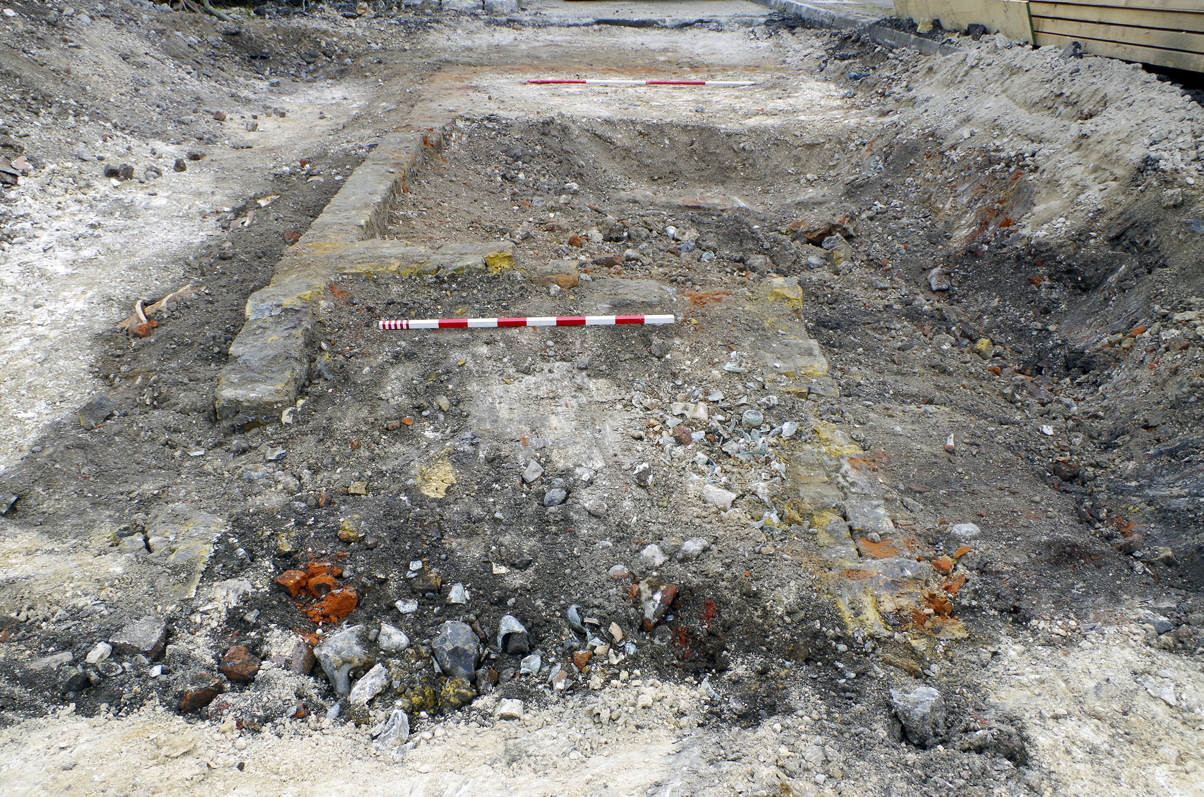
It is unclear if the north side of Horn Yard was redeveloped between the compilation of the 1840 tithe map (Figure 4) and the 1866 Ordnance Survey map (Figure 5), with some structural elements possibly retained. Wall 1134 formed the east end of a range of buildings and was constructed from rough red bricks. By 1866, additional buildings (one indicated with a dashed line - a covered area?) had been developed to the south within the former extent of Horn Yard. The foundations of these structures survived, comprising red and yellow brick walls (1238; Figure 30). By 1932 (Figure 9) these buildings had been replaced with a range of garages, which are visible on the 1933 aerial photograph. Rectangular pit 1131 within the footprint of one of these garages might be the truncated remains of an inspection pit used to service motor vehicles.
The functions of most of the buildings revealed in Horn Yard are unknown. A range of trades were carried on, as evidenced by newspaper records. Francis Bandemont was a French veteran of Waterloo, who was an unostentatious egg merchant (The Gravesend Reporter, 16 March 1861). J. White had been a cutler working from 3 Horn Yard for 38 years in 1870 (i.e. beginning 1832; Gravesend and Dartford Reporter, 12 March 1870). A large quantity of timber building materials in Horn Yard was auctioned off, suggesting the presence of a joiner or similar trade (Gravesend and Dartford Reporter, 26 January 1878). Less legitimately, two men, including Albert Winter of 6 Horn Yard, were thought to be bookmaker's runners. They were fined for obstructing the footway on the town quay, but said they were innocently looking at a horse for sale (Gravesend and Northfleet Standard, 26 October 1895).
The town surveyor was of the opinion that Horn Yard was a private road and not repairable by the inhabitants at large (The Reporter, 30 September 1905). Tarmac, concrete and granite sett surfaces, including part of the pavement, were revealed by the excavation but were all of recent date.
The Kent HER (TQ67 SW 458) records that a 19th-century ice well once existed at 'Horns Place [sic], Gravesend' - presumably this was Horn Yard. The HER records that 'the well was 3.55m wide and c. 8m deep and brick lined. Originally it would have been filled with ice which would have been removed as required'. The HER gives Kent Underground Research Group 2001 as the source of this information, although this document could not be found during compilation of this article.
The 1861 census records an 'Icehouse' on Bank Street, 'Icehouse' being given as the name of the house in place of a number. It was inhabited by the family of Charles Burling, 'fruit carman' (i.e. he delivered fruit).
By 1865, John Hopper, Confectioner and Ice Merchant was advertising 'Wenham Lake and English Ice' from a shop on the corner of High Street and Bank Street (Gravesend and Dartford Reporter, 3 June 1865). It is likely that the ice well was located at the rear of these premises on Horn Yard, but outside of the boundaries of the site.
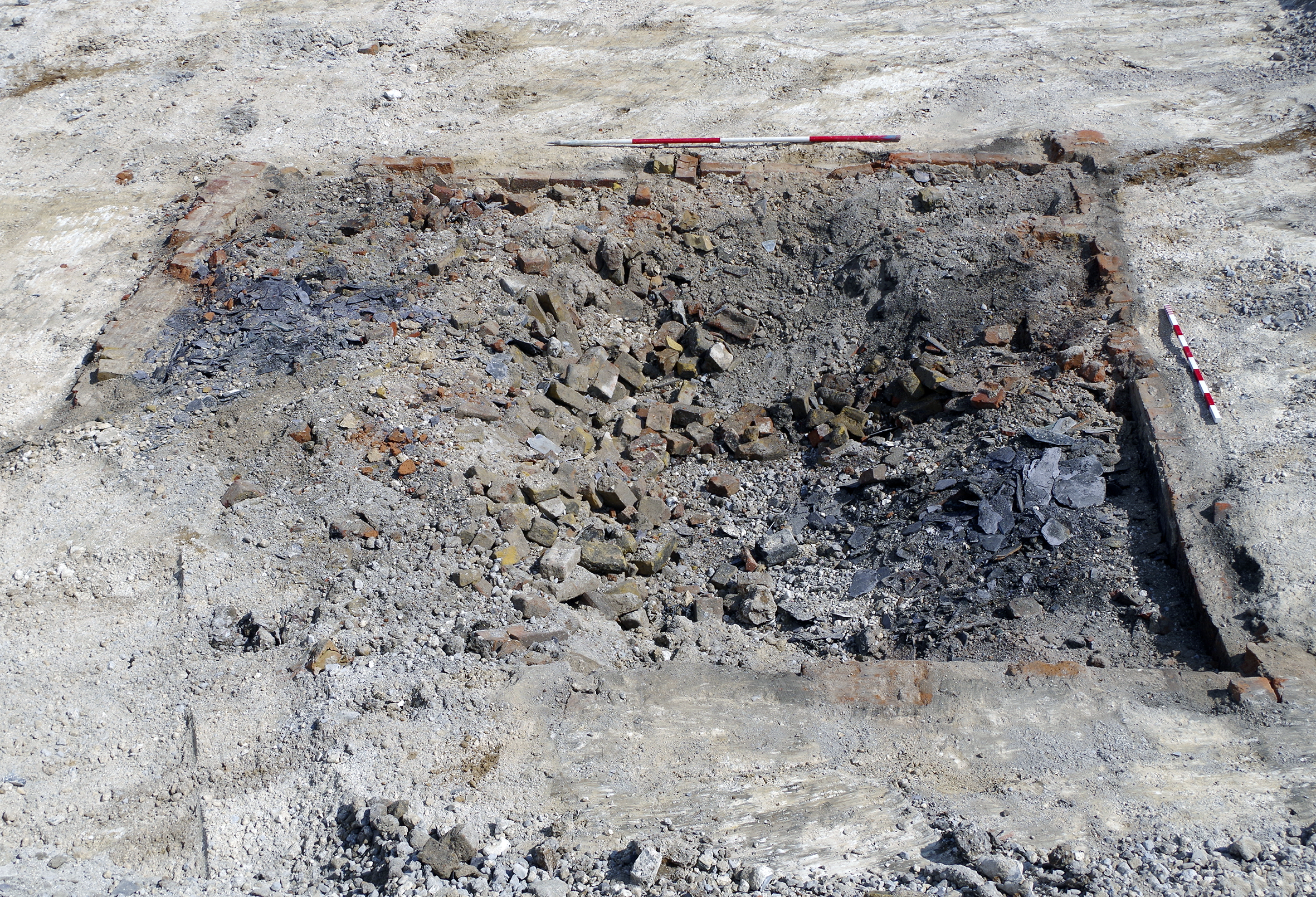
The southern side of Bull Yard incorporated a square mapped from 1840 to 1932 (Figs 4, 5, 8 and 9). This square was surrounded by rectangular buildings. The 1841 census recorded 21 households in Bull Yard, so it may be that these buildings were primarily dwellings. The remains of plastered red and yellow brick cellars (1220; Figure 31) evidenced three small buildings mapped west of the square. Two further red brick buildings continued the range to the south (1217 and 1233), with their rears accessible from an offshoot of Horn Yard. Cesspit/well 1231 pre-dated the construction of these buildings. The square contained a central well (1236) and a red brick tank (1229), perhaps public water provision (Figure 10) (Section 4). These buildings were still depicted on the 1932 map (Figure 9) and can be seen on the 1933 aerial photograph, although no significant detail can be made out. The area was largely redeveloped as an engineering works by the time of the 1955 map (Figure 22), which was represented by concrete surfaces. The survival of handmade red brick and lime mortar walls suggests that parts of existing buildings were retained within the fabric of the engineering works.
On the south side of Bull Yard were two dwellings, where the remains of the yellow plastered brick cellars were revealed (1135; Figure 32). These houses appear on the 1840 map (Figure 4), were shown in detail in 1866 (Figure 5, where they are depicted with either front steps or coal chutes) and persisted until at least 1955 (Figure 22). They are clearly visible on the 1933 aerial photograph, which reveals them to be plain, three-storied and gabled with a single central chimney. These houses had only a small, shared yard. Red brick wall 1136=212 formed the southern limit of this yard, dividing the Bull Yard properties from those in Horn Yard.
A terrace of five houses was present north of Bull Yard, with gardens or yards at the rear. This terrace was mapped between 1840 and 1955 (Figs 4, 5, 8, 9 and 22). The 1933 aerial photograph shows them as three-storey buildings, with a single shared gabled roof and chimneys front and back. These houses were more regularly laid out than many of the buildings in the area and may have been better planned and constructed, perhaps a cause of their longevity. The plastered red brick cellars of these houses were revealed (1237; Figure 33). The cellars were located beneath both front and back rooms of the houses, with the location of stair access probably indicated by a small wall near the spinal interior dividing wall, although preservation was not sufficient for certainty.
A well ('W') (Section 4) was mapped in 1866 in the rear of one of the gardens of these terraced houses but was not identified during excavation. Nearby, cesspit 1202 correlated precisely with a privy mapped in 1866 (Figure 5). The shape of the gardens deviated from the rectangular here, perhaps to give access for the removal of night soil. This arrangement may indicate that the soakaway that pre-dated the construction of the terrace (Section 1.6) was opportunistically reused. This explanation may also explain the absence of deep soakaways beneath the other privies of the terrace.
Sometime between 1866 (Figure 5) and 1909 (Figure 8), the terrace was extended to the west using yellow bricks (1139), in contrast to the red bricks of the main part of the terrace (Figure 34). Unlike the main houses, this extension was not associated with a garden and may have been either another dwelling or a different kind of building such as a workshop or an extension. Its absence from view on the 1933 aerial photograph suggests that it was only a single storey high.
Further buildings were mapped east of this terrace. These were evidenced by the fragmentary remains of red brick walls (1144 and 1150). Wall 1144 perhaps divided Bull Yard from a small front yard, whereas 1150 may have been the front wall of the building proper. These walls contrasted with the alignment of the road depicted in 1840 (Figure 4), suggesting that they had been built between 1840 and 1866 (Figure 5). The interior of the building represented by wall 1150 had later been floored with poured concrete; however, as this floor contained two drain inspection chambers it is probable that it was installed post-demolition, with part of wall 1150 retained at the perimeter of Bull Yard.
In 1897, Councillor Waters instructed a surveyor to inspect the surface of Bull Yard, with adjacent landlords charged for the completed work (Gravesend and Northfleet Standard, 25 December 1897; 3 March 1900). The remains of the surface of parts of Bull Yard were revealed by excavation. Cobblestones 1221 may have been 19th century in origin (Figure 35), but the majority of the surviving surface comprised a pattern of granite setts, concrete slabs and poured concrete or tarmac, these probably all from the 20th century.
A major west to east red brick wall (1203/1210) divided the Bull Yard properties from those south of Crooked Lane. Wall 1203/1210 had been partly replaced with a 20th-century wall (1204), unusually constructed from repurposed (and potentially reused) granite setts and Portland cement (Figure 36). Most of the alignment of wall 1204 replaced that of the truncated 1203/1210; however, it curved north in the west. Wall 1204 was probably a late 20th-century landscaping feature, perhaps associated with the realignment of Crooked Lane and the early use of the site as a car park. The 1955 map (Figure 22) shows that the alignment of Crooked Lane had been altered slightly, although not to the extent it appears today, and it may be that wall 1204 was contemporary with this phase of redevelopment.
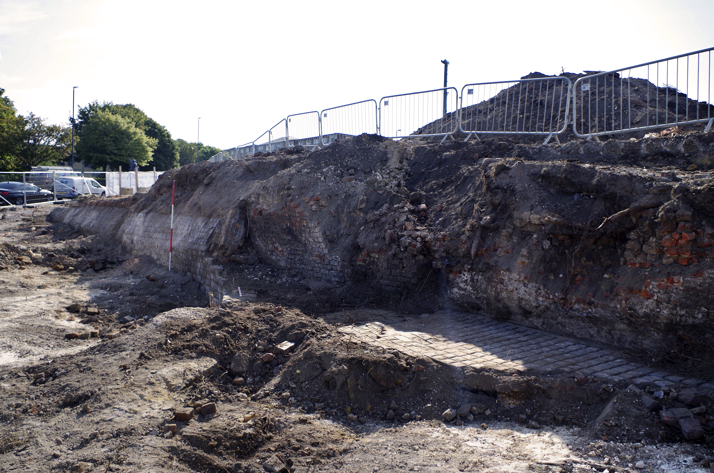
A newspaper advertisement from July 1862 provides a terminus ante quem for the construction of a foundry depicted on the 1866 map, labelled 'Foundry (Brass & Iron)' (Figure 5). The advertisement reveals that G. Butchard had taken over this works from Messrs Troughton and Bevan and could supply 'Steam Engines and Boilers, Pumps, Cranes, Crabs, Millwork and every description of Machinery and Castings' (The Gravesend Reporter, 19 July 1862). Another newspaper report recounts that a stranger stole a screw tap, value 5s, from the works (Section 3), indicating that iron turning was undertaken. Henry Dean, the iron trimmer who made the screw tap, fought the thief through the streets to recover the item (Gravesend and Dartford Reporter, 3 September 1864). Butchard's endeavour at the iron foundry did not seem to go well as Messrs Hammond and Son auctioned off all of the equipment on 12 December 1866 (Gravesend and Dartford Reporter, 1 December 1866). Hughes and Co. appear to have taken over but quickly went bankrupt and the foundry was again subject to auction. The advertisement for this second auction listed the following equipment at the works: '10½ inch centre self-acting screw-cutting lathe, a 6 inch ditto, a double geared upright drilling machine by Blacket, a 6-horse power horizontal engine by Power, James and Co., a 3-horse power engine and boiler, a 6-horse power flued vertical boiler, a punching and shearing press for ¾ inch plate, Schieles' patent and other fans, a 4-ton furnace crane, sheer legs, Smiths' forges, vices, anvils, benches, a quantity of steel tools, wrought iron, cast scrap iron and numerous other effects' (Gravesend and Dartford Reporter, 5 September 1868). The foundry continued to be occupied, as a brick making machine located in Northfleet was to be demonstrated to prospective buyers by Mr Holt at the Bull Yard foundry (Gravesend and Dartford Reporter, 3 July 1869). By 1874 the foundry plot was being advertised for redevelopment as cottages (Gravesend and Dartford Reporter, 22 August 1874). Unfortunately, nothing survived of the foundry below ground.
Later, Edward Beer (formerly J.W. Hedgkin) advertised his services as a smith from Bull Yard (he lived elsewhere; Gravesend and Dartford Reporter, 21 April 1888). This may have been at the former foundry. There was still a smith shop in Bull Yard in 1904, as it was advertising for a strong active lad (Gravesend and Northfleet Standard, 27 August 1904). The plot had been cleared by 1909 (Figure 8).
By the time of the 1955 Ordnance Survey map, a new, long building was depicted in this location. The base of its walls survived, comprising 20th-century textured brick and Portland cement (1223, 1225), enclosing a concrete surface (1224).
East of the foundry, a fragment of a substantial four-skin red brick wall (1228) survived to the north of Bull Yard, but the specific locality was undeveloped on every consulted historic map. The area of wall 1228 was depicted either as part of Bull Yard itself, or (in 1866, Figure 5) within a small, enclosed yard next to the square. Perhaps the wall served as the base for a feature such as a trough.
North of wall 1228, another fragment of wall (1206) comprised yellow bricks and may have been an interior division of a building that otherwise did not survive (Figure 5).
The modern alignment of Crooked Lane formed the north-east boundary of the site. However, prior to the late 20th century the course of this lane was more crooked than at present, placing the 19th-century frontage outside the boundary of the site.
A building shaded grey on the 1840 tithe map (Figure 4) on the south side of Crooked Lane was within the site boundaries; however, no remains of this structure were identified. This building was slightly larger than a terraced house and was aligned along the lane, suggesting mercantile or small-scale industrial premises. Trade directory entries from the 1850s for Crooked Lane may refer to this property. There are entries for Warren, G, beer shop; Savage, D, green grocer; Osbourne, Mrs (no occupation given); Watson, S, carter; Williams, Mrs, fishmonger; Nodden, J, shoe maker (Gravesend and Milton Directory 1851); Underhill, Henry, beer retailer; Lear, Thomas, shopkeeper (Kelly and Co. 1855); Dadson, Thomas, fishmonger; Gilbert, Thomas, beer retailer; Hughes, Henry, grocer etc.; and Mrs Roxberry, fishmonger (Melville and Co. 1858). The directory entries suggest that shops changed hands frequently. This may not have been an address that nurtured successful businesses. Another reason for the changing occupants may have been the total redevelopment of the area south of Crooked Lane between the compilation of the 1840 and 1866 maps.
Following this redevelopment, the 1866 map (Figure 5) shows small rectangular buildings and yards fronting Crooked Lane. Of these buildings, only interior red brick wall 1212 and yellow brick surface 1213 survived (Figure 37). A textured poured concrete floor (1211) had been added, probably in the early 20th century. Well/cesspit 1214 (Section 4) was located centrally within the same building.
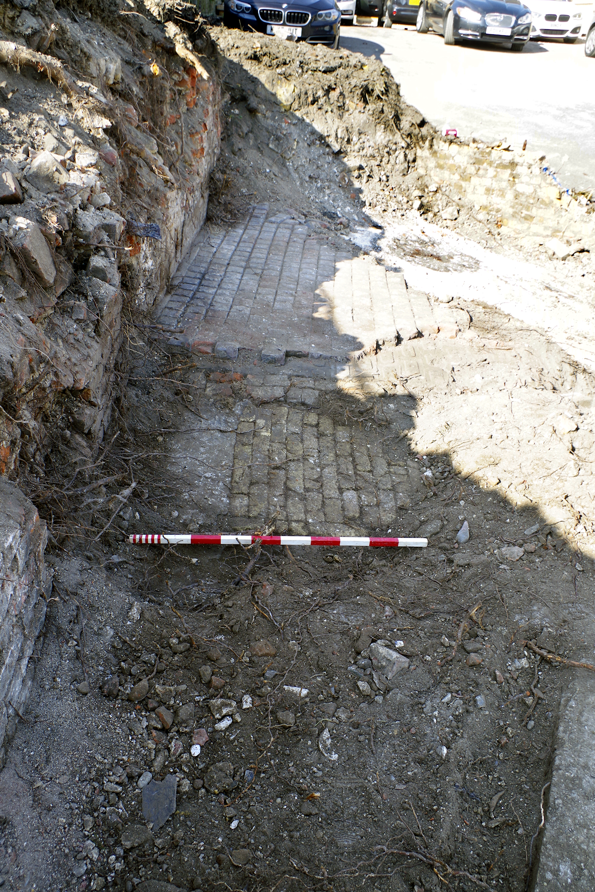
Queen Street is a road aligned north to south forming the eastern boundary of the site. It is larger than the passages, but not large by modern standards. Numerous occupants and activities are listed in trade directories for Queen Street; however, it has not been possible to positively relate any of these to the area of the site.
A range of four buildings fronted Queen Street between Market Alley and Swan Yard. The buildings are visible on maps from 1840 to at least 1955 (e.g. Figs 4, 5 and 22). These brick buildings were of superior construction to the neighbouring wooden buildings on Market Alley. The Queen Street buildings had foundations built from an opportunistic mix of red and yellow bricks, (Section 1.7) with a few black engineering bricks thrown into the mix (1030, 1033, 1038; Figure 38). Walls 1030 and 1038 correlate with the spinal wall of the northern two buildings, with traces of plaster on the east side revealing the presence of cellars on the Queen Street frontage. These cellars could not be investigated further owing to their proximity to the site boundary.
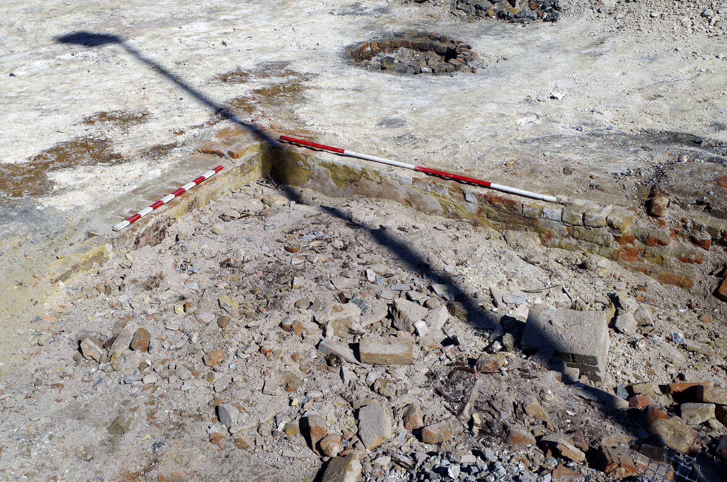
Adjacent to cellar 1030, but largely outside the site boundary, the house on the corner of Queen Street and Market Alley was occupied by Mr William Box (Gravesend and Dartford Reporter, 12 July 1879; Figure 7). In 1866 Mr. Box and a Dr Gramshaw had complained to the improvement commissioners about a 'nuisance caused by some pig styes [sic]' (Section 4) in Swan Yard. 'Mr. Box's children were ill by inhaling the effluvium which arose from the filthy soil' (Gravesend and Dartford Reporter, 11 August 1866). It had been planned to demolish the whole block between Market Alley, Swan Yard and Queen Street (Section 2 - expansion of the market); however, following purchase by the council, the house of Mr Box was to be reported on by the Sanitation Committee (Gravesend and Northfleet Standard, 11 October 1902). Presumably the house was found to be satisfactory as it and its three northern neighbours (1030, 1033 and 1038) were retained long into the 20th century.
In 1955 these four houses were labelled as numbers 25-31 (Figure 22), but it is probable that these are not the same numbers used during the 19th century. It has not been possible to identify a systematic 19th-century numbering system on Queen Street. Public houses identifiable both on historic maps and in trade directories show that the 19th-century numbering of Queen Street was not systematic, with odd and even numbers on both sides of the road and with unequal distances between numbers.
North of Swan Yard, the 1840 tithe map (Figure 4) depicts a terrace of five houses fronting Queen Street. On a 1933 aerial photograph (Tom Baines pers. comm.; not reproducible) these are clearly visible as a two-storey terrace with a shared hipped roof. Each house had one front window per floor. Extensive remains of the coal cellars under the front rooms of these properties survived, including red and yellow brick walls (1036, 1112, 1113, 1114, 1116 and 1117; Figures 39 and 40).
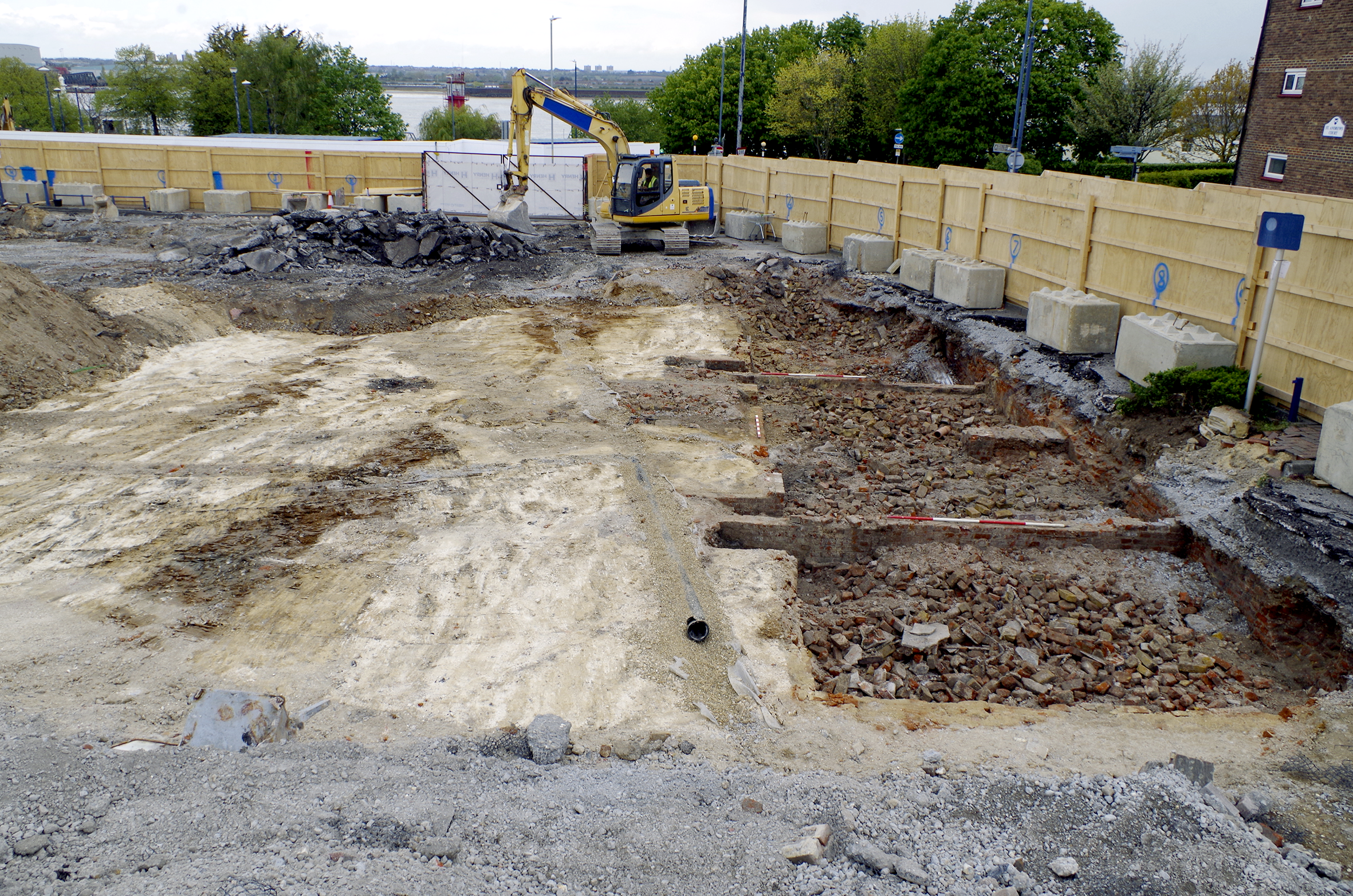
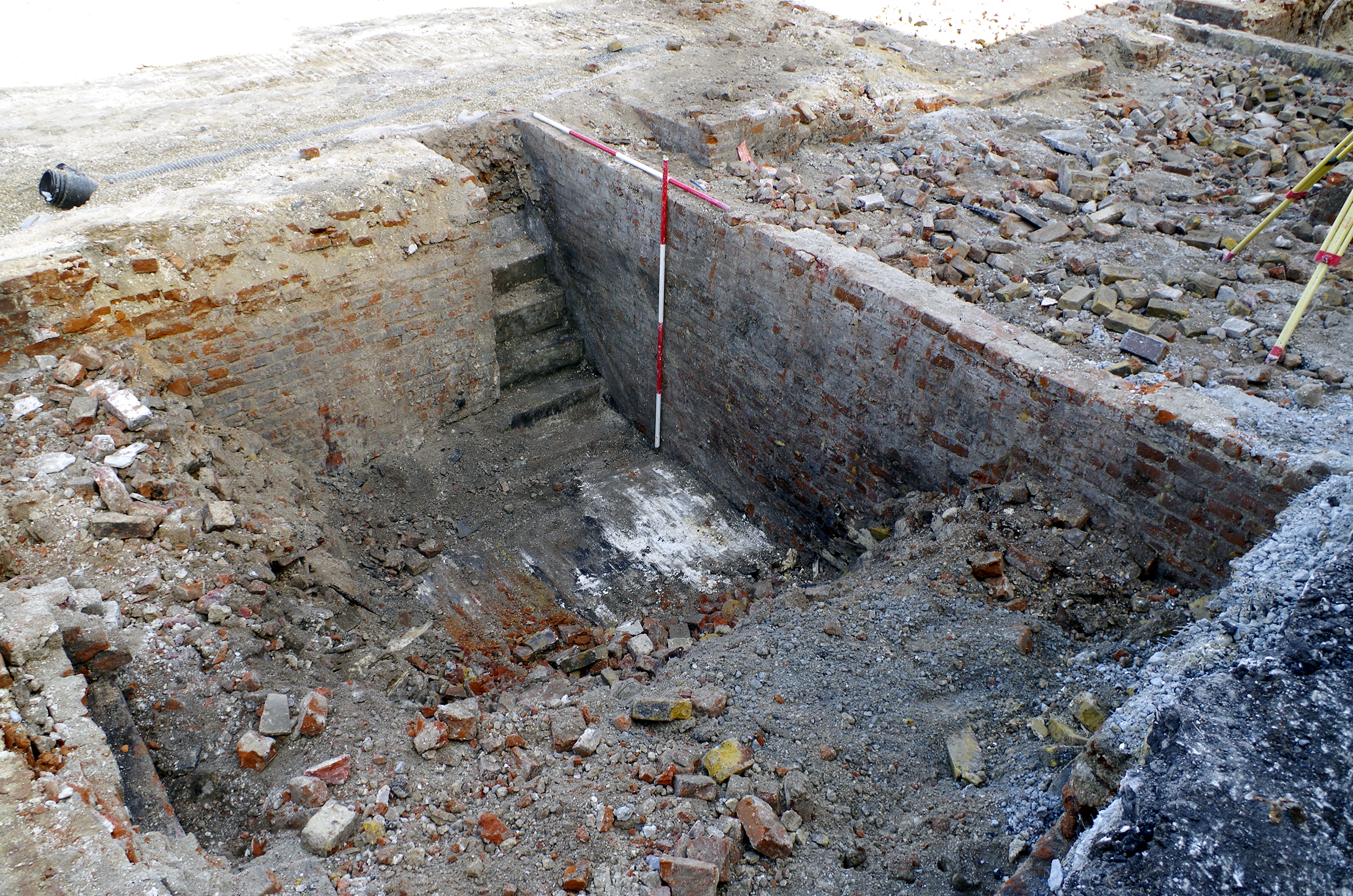
These walls incorporated the foundations of fireplaces at ground level, and a semi-circular recess (Figure 41) in wall 1113 was probably a coal chute. Access to each cellar was via straight stairs from the rear (i.e. under the rear rooms of the houses). In two houses, the stairs had been resurfaced with concrete, indicating repair in the 20th century (Figure 40). One of the houses was different in having a second cellar under the rear room (1115=610), built in identical materials to the main cellars and therefore probably original, although these materials had a long currency. These houses continued to be mapped until at least 1955 (22), when they were numbered 33-41.
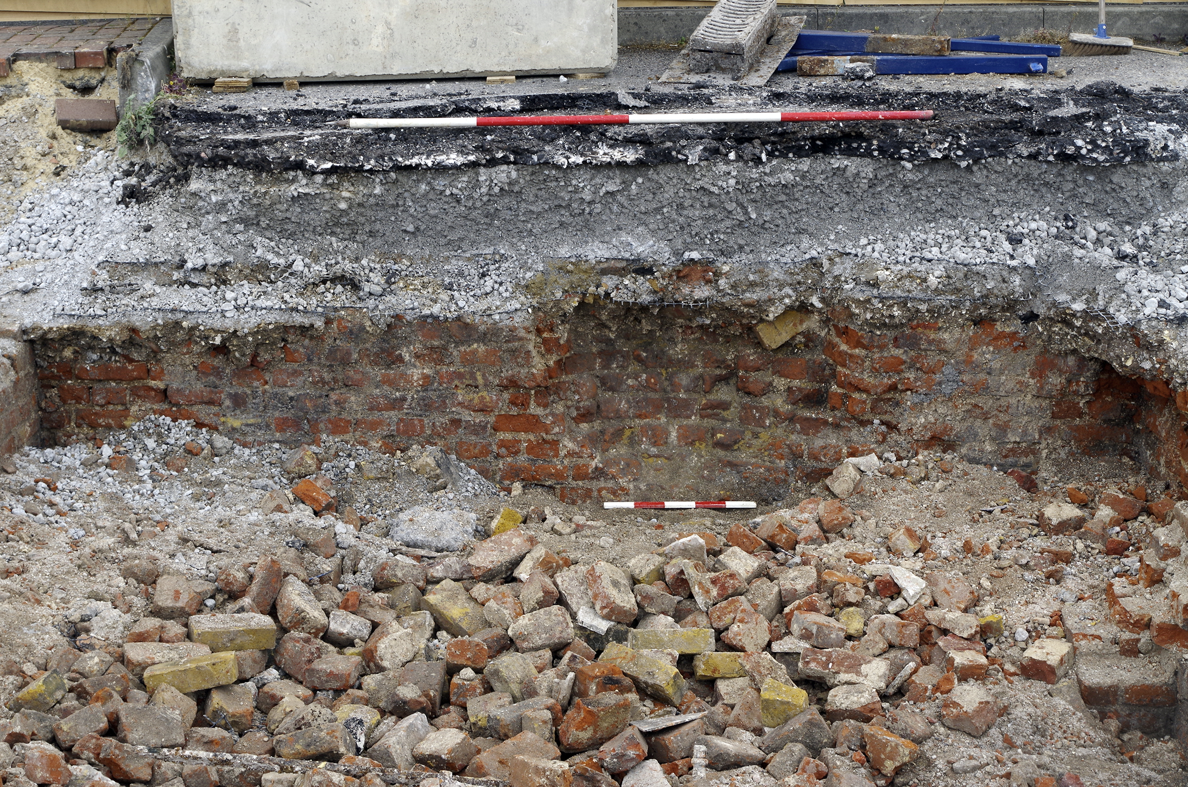
Each house had a privy at the bottom of the garden. The base of a pair of these was revealed (1084), built from red and yellow bricks (Figure 42). Nearby, but not directly underneath privy 1084, was the remains of a cesspit (1045; Figure 10). Cesspit/well 1110 was located under the mapped scullery of one of the houses and probably pre-dated them.
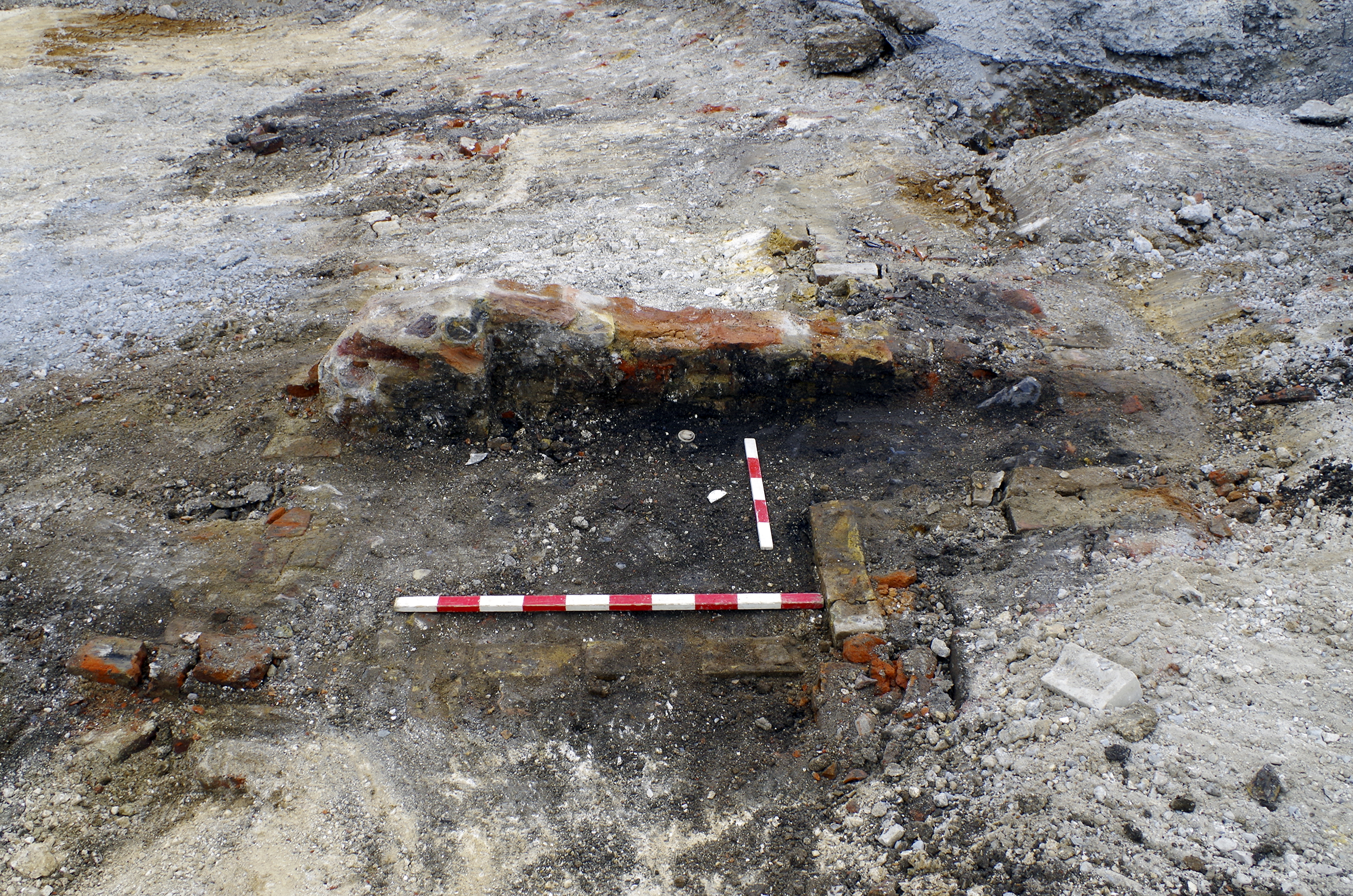
The original five houses had expanded north to reach Bank Street by the time of the 1866 map (Figure 5). The 1866 map is detailed enough to show paths in the back gardens of these houses. The aerial photograph shows three separate houses on slightly different alignments with separately constructed roofs. Two of the houses have two windows on each of two storeys, with the house on the corner of Bank Street three storeys high with multiple windows and a shopfront on the ground floor. By 1955 they were numbered 43-47 (Figure 22). The boundary between the two sets of houses was defined by a red brick wall (608/609 and 1126); any walls demarcating other plot boundaries between these houses did not survive. The cellars of the three northern houses comprised the usual red and yellow bricks and were partly preserved (1119, 1120, 1121; Figure 43). Poorly preserved brickwork probably indicated the position of a staircase leading west from cellar 1121. Again, the foundations of fireplaces were present.
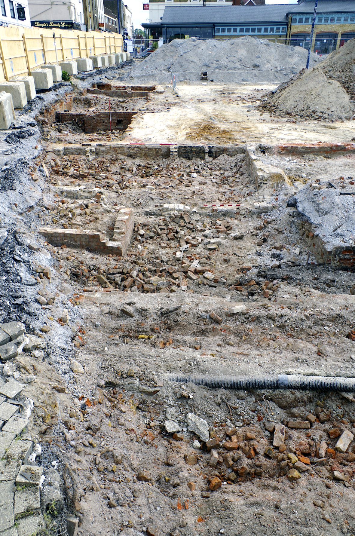
Unlike the earlier five houses that had privies at the rear of their yards, the 1866 map shows that the newer three possessed privies built adjacent to the offshot sculleries (sculleries are present on all eight houses). This arrangement suggests that connection to a central sewerage system was available at the time of their construction. The privies were not evidenced archaeologically; however, three cesspits or wells (1123, 1124 and 1125; Figure 10) were arranged irregularly within the gardens.
A later frogged 'LBC' (London Brick Company) machine brick and Portland cement structure (1128) had been constructed within the footprint of cellar 1120. It is likely that this was a service structure such as an electrical installation, post-dating the demolition of the house. Given that the house to which cellar 1120 belonged persisted on historic maps until at least 1955 (Figure 22), the date of this structure (1120) was probably late 20th century or early 21st century.
Gravesend developed around a series of parallel roads, including High Street and Queen Street, leading back perpendicularly from the Thames estuary. The excavated site primarily comprised part of an area of narrow pedestrian passageways and yards providing links between these streets, with nothing to indicate settlement here before the late 18th century at the earliest. The passageways accessed low-status slums to the rear of more visible (and higher status) properties on the larger roads, the area developed piecemeal to meet immediate needs rather than following any overarching plan. Dwellings were generally small and may have been poorly constructed. Rough concrete linings added to 19th-century cellars on Swan Yard may by evidence of the inadequacy of the original building techniques. A general trend for cellars to have been bricked up across the site may reflect their poor quality. Documentary evidence has filled in the archaeological voids, revealing that much of Swan Yard and Market Alley were developed as an inadequate higgle piggle of wooden housing and commercial premises.
It is surprising to read nothing of these passageways in the trade directories, when newspaper accounts make clear that much economic activity was taking place there. This activity was as diverse as the buildings, with Market Alley known for 'slaughterhouses, piggeries, warehouses, and common lodging-houses, mixed together in a most extraordinary manner' (Gravesend and Dartford Reporter, 12 July 1879; Figure 7). There was a coach-house, stables, carpenter's shop, several slaughterhouses, warehouse or store, piggeries, lofts and cart shed on Swan Yard. Horn Yard supported at least an egg merchant, cutler, joiner and probably a bookmaker's runner. Bull Yard even contained a foundry (albeit short lived) and later a smith. Alongside these mercantile and industrial endeavours, many people lived in these small yards. The population as recorded by censuses was approximately static from 1841 throughout the 19th century, not reflecting the increasing population pressure felt nationwide, and despite the deterioration and depreciation of the poor-quality buildings. Perhaps these two factors cancelled each other out. It appears that the passageways were already fully occupied by 1841.
The main visible change to this was the construction of Bank Street in the 1850s. This transformed part of the site into a prime development area in the centre of Gravesend. Bank Street was wider than the passageways but was still smaller than modern roads, connecting the narrow medieval High Street with Queen Street. Along with Queen Street, Bank Street was of a different character to the rest of the site, supporting superior, probably middle-class dwellings, shops and a coach factory. This was the main industrial component to the site and provided a rich vein for documentary research. The factory was a medium-scale employer, and the family inhabited a valuable house within the site, as well as owning property elsewhere. They lived comfortably, supported by a servant. As with biographies of other similar families (e.g. Tuck 2023), the Gates family rose from humble beginnings of hard work, through periods of status and relative wealth into inevitable decline.
Nevertheless, the records of crime identified from newspaper reports paint a shocking story of the neighbourhood, including heartbreaking accounts of some of the most serious offences. Even beyond the immediate confines of the slum described here, the streets of Gravesend were a contested space. Examples of this are the Watermen's Riot of 1833 (e.g. Discover Gravesham 2023g) and the Salvation Army Riots of 1883 (e.g. Gravesend and Dartford Reporter, 20 October 1883). But it is clear that disturbances were a regular event, with the Town Clerk complaining to Lord Palmerston (then home secretary, later prime minister) about traditions around bonfire nights. The letter described rival mobs roaming with blackened faces, bludgeons, torches and squibs (small explosives; Public Record Office HO45/5/28). The actions of the magistrates and police appear to have had only momentary results and to have been ineffectual at creating public order. Underlying this unrest was an environment of theft, assault, problem drinking, obscene language, sex work, domestic abuse, child neglect, manslaughter and murder. It should not be a surprise that when groups of people are held in poverty and housed in an unsanitary 'pressure cooker', bad things happen.
Little archaeological dating evidence was identified other than the nature of the structures themselves, but a broad chronological sequence has been defined by correlating the excavated remains with historic sources, chiefly maps. This has revealed a date range for initial building construction in 1770-1840, with (re)development continuing at a slower pace throughout the 19th century and into the 20th. However, there were no significant differences in materials and forms throughout the main period of occupation of the site. This only changed in the 20th century, when maintenance and limited redevelopment was undertaken using concrete, machine bricks and Portland cement.
The buildings on the site were gradually demolished throughout the 20th century. The first seeds of clearance came around the turn of the century when some of the area between Swan Yard and Market Alley was demolished to provide better access to the market. Clearance then continued piecemeal in the decades following. Although nationwide campaigns of slum clearance were undertaken in the 1930s following acts of parliament such as the 1930 'Greenwood' act (Housing Act 1930), there is no indication that the site was subject to systematic clearance. The piecemeal demolition appears to have been a response to immediate needs, mirroring the circumstances of construction. The same systems of power and landholding were probably at work during both construction and demolition. The latest surviving structures, such as some of the housing on Bull Yard, as well as the higher-status housing on Bank Street and Queen Street, may have been the best constructed and most durable.
Fieldwork was directed by Lisa McCaig and undertaken by Dan Leaver, Matt Fleming, Albert Smith, Elliot Gribbin and Elisha Meadows. The project was managed for Wessex Archaeology by Rob De'Athe (fieldwork and post-excavation assessment) and Kirsten Dinwiddy (publication). The original report was edited by Phil Andrews. The illustrations are by Rob Goller, incorporating work by Esther Escudero. Interactive illustrations were created by Ian Atkins.
The kind permission of Kent Archives and Local History Service to reproduce an extract from the 1840 tithe map is acknowledged.
Comments on the contents including additional newspaper clippings were received from Geoff Baker, Senior Planner at Gravesham Borough Council.
Genealogical information and The British Newspaper Archive were accessed via the commercial website Find My Past. The British Newspaper Archive is copyright The British Library Board; extracts are reproduced by kind permission.
The site falls within an area where there is currently no collecting museum. The physical archive will be subject to a retention strategy and is currently held at the offices of Wessex Archaeology in Meopham under project code 233911 until a permanent home can be found. The digital archive will be deposited with the Archaeology Data Service. An OASIS form (wessexar1-505651) has been provisionally completed for this project.
Internet Archaeology is an open access journal based in the Department of Archaeology, University of York. Except where otherwise noted, content from this work may be used under the terms of the Creative Commons Attribution 3.0 (CC BY) Unported licence, which permits unrestricted use, distribution, and reproduction in any medium, provided that attribution to the author(s), the title of the work, the Internet Archaeology journal and the relevant URL/DOI are given.
Terms and Conditions | Legal Statements | Privacy Policy | Cookies Policy | Citing Internet Archaeology
Internet Archaeology content is preserved for the long term with the Archaeology Data Service (ROR). Help sustain and support open access publication by donating to our Open Access Archaeology Fund.
 Home
Home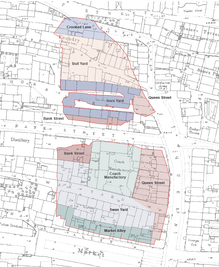
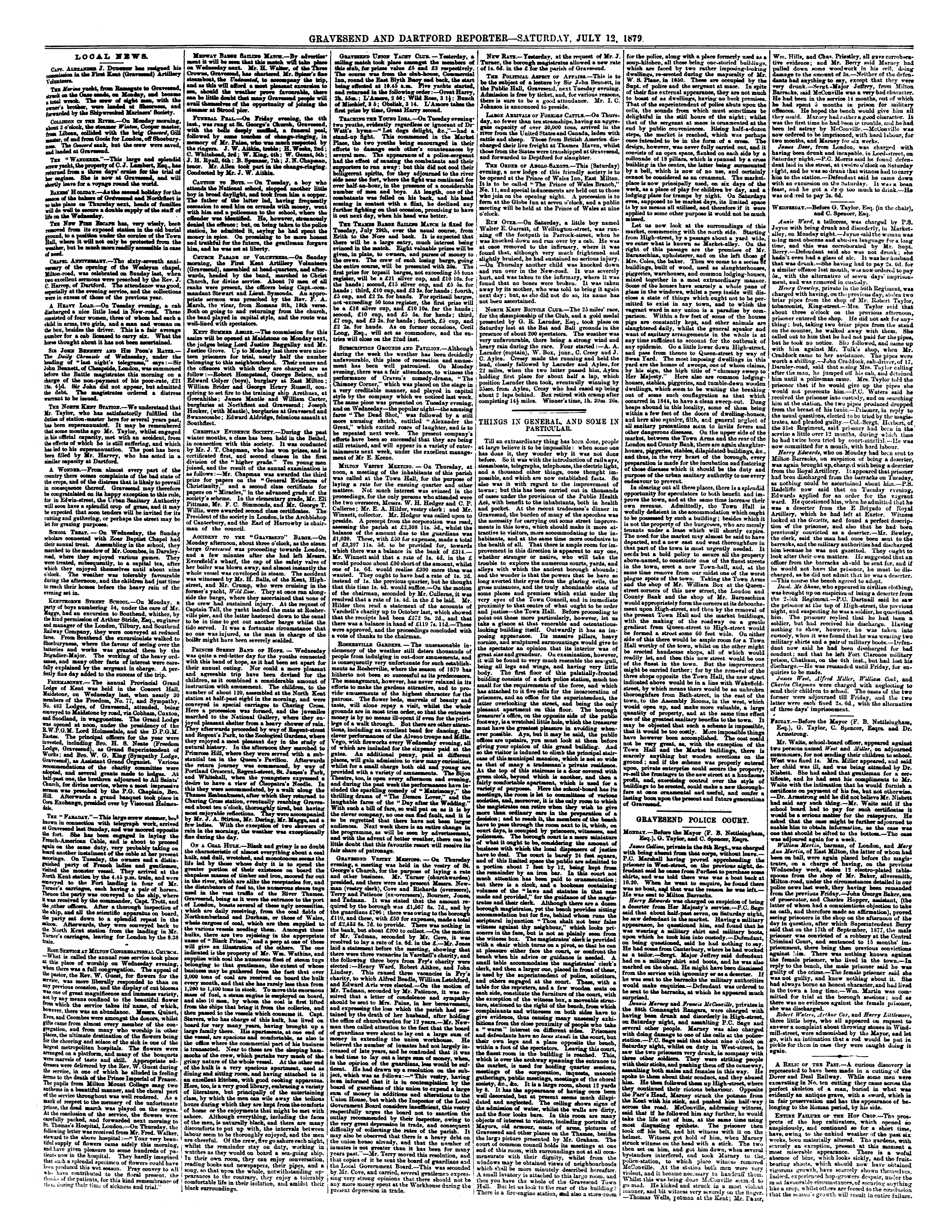