Cite this as: van Tongeren, T. 2026 Furnace Fields: Iron Age and Roman Metalworking between York and the Humber, Internet Archaeology 71. https://doi.org/10.11141/ia.71.11
An archaeological investigation, undertaken by Headland Archaeology (UK) Ltd, and associated with a proposed renewable energy development at Thornton in the East Riding of Yorkshire (Figure 1) revealed extensive evidence for middle Iron Age to early Roman industrial activity. The remains were identified across a 150ha site in the south-eastern Vale of York, demonstrating that this now largely agricultural landscape was once intensively used during later prehistory and the early Roman period. The proposed Thornton SOAY Solar Farm and Greener Grid Park is located between Thornton and Allerthorpe, within a gently undulating landscape bounded by the Yorkshire Wolds to the north and the low-lying floodplains of the Humberhead Levels. The site sits on Mercia Mudstone bedrock overlain by alluvial sands (British Geological Survey; Evans et al. 2018, 885), at elevations approximately 13–14m above Ordnance Datum (AOD). High groundwater levels were encountered throughout the archaeological investigations.
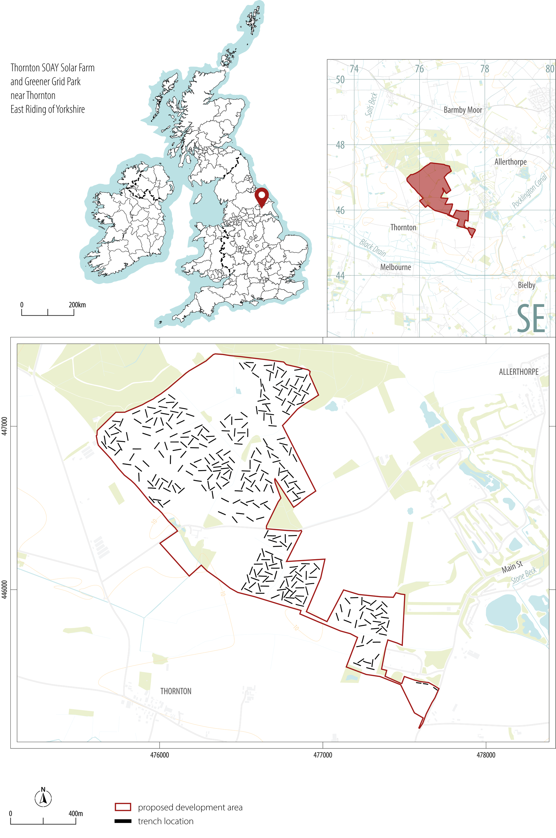
Earlier non-intrusive surveys had suggested that significant archaeological remains were present. Analysis of cropmark data derived from Historic Environment Record (HER) aerial photography (Arcus 2021) and a geophysical survey covering much of the site (Lawton 2021) suggested the presence of more than 500 archaeological features, concentrated mainly in the central and northern parts of the site. Although not datable through non-intrusive methods, these features were interpreted as trackways, enclosures and possible settlement activity of later prehistoric or Roman date. A dense cluster of linear features in the north-west was considered indicative of a Roman settlement with an associated rectilinear or co-axial enclosure system. On this basis, six core areas of high archaeological potential were defined (Figure 2).
Evaluation trenching confirmed these as archaeological hotspots, while also identifying additional areas of interest. Despite the density of archaeological remains, most of the site was not subject to full mitigation due to the limited ground impact anticipated from the solar array infrastructure. Preservation in situ was therefore adopted as best practice, resulting in an unusual scenario whereby the results of a large-scale evaluation, rather than a full excavation, formed the basis of analysis and publication. The works were commissioned by Statkraft UK Ltd and groundworks undertaken by Headland Archaeology in 2023. Fieldwork comprised a trial trench evaluation of 333 trenches and a 0.24ha strip, map and record mitigation area.
This publication begins with an explanation of the radiocarbon dating programme, followed by an overview of the excavation results and a specialist interpretation of the iron-smelting evidence. The final section considers the wider significance of the site within the Iron Age and Roman landscape of eastern Yorkshire.
As part of the analysis, a targeted programme of radiocarbon dating was undertaken, comprising 10 samples (Table 1; Figure 3). These were intended to date the main areas of activity and to test chronologies suggested by pottery and other finds. Additional samples were included to explore the development of settlement activity and possible post-Roman use of the site. The availability of suitable dating material was limited. In several cases, including 14C date number 3 (Table 1), it was therefore necessary to date features closely associated with the intended feature rather than the target feature itself.
The radiocarbon results indicated that the principal phases of activity spanned the middle Iron Age to Roman periods. Dates linked to iron-smelting activity in Core Areas 2 and 3 clustered in the middle Iron Age, broadly between the fourth and second centuries BC, suggesting sustained industrial activity. Results from Core Areas 4 and 5 indicated continued activity with an industrial focus into the late Iron Age and early Roman periods. A small number of later Roman dates suggested ongoing, though more limited, site use with a changing pattern of activities. Full details of the radiocarbon determinations and their archaeological context are presented in Table 1.
All samples were analysed by the Scottish Universities Environmental Research Centre (SUERC), Centre for Isotopic Sciences, East Kilbride, following standard procedures (Dunbar et al. 2016, 9–23). Radiocarbon determinations were calibrated using OxCal v4 (Bronk Ramsey 2009, 337–360) and the IntCal20 atmospheric calibration curve (Reimer et al. 2020, 725–757).
| 14C no. | Context no. | Material | Reasoning | Result (95.4% probability) |
|---|---|---|---|---|
| 1 | 001011 (EV Trench 1) Ditch fill representing a dumped deposit. Fill contained c.1200g iron slag and 10 sherds of Roman pottery. | Black alder charcoal | Provides a date for industrial activity in the south-eastern part of the site, based on a dumped ditch fill sealed by natural deposits and containing substantial quantities of iron slag and Roman pottery. | 346–53 cal BC (SUERC 129759) |
| 2 | 040008 (EV Trench 40) Core Area 1 Primary fill of a ditch, containing fired clay and Roman tile. | Spelt grain | Dates enclosure activity in Core Area 1. Concentrations of cereal grains, animal bone and fired material indicate agricultural or domestic activity, while waterlogged conditions suggest short phases of ditch use. | cal AD 241–381 (SUERC 129769) |
| 3 | 067008 (EV Trench 67) Core Area 2 Primary fill of a ditch, containing 10 sherds of Iron Age pottery and animal bone. | Equid pelvis | Provides the closest available date for industrial activity associated with the enclosure system identified in Trenches 85/86. | 383–201 cal BC (SUERC 129771) |
| 4 | 123011 (EV Trench 123) Core Area 3 Primary fill of a ditch, representing a dumped deposit. Fill contained 530g of smelting slag, two sherds of Iron Age pottery and fired clay. | Black alder charcoal | Date relates to activity associated with nearby industrial features, derived from a dumped ditch fill containing smelting slag, Iron Age pottery and fired clay, with plant remains suggesting possible domestic activity. | 377–197 cal BC (SUERC 129760) |
| 5 | 127005 (EV Trench 127) Core Area 3 Primary fill of a ditch, containing heather stems and burnt animal bone. | Black alder charcoal | Dates an enclosure ditch closely associated with industrial activity in Core Area 3, with burnt bone and heather stems indicating domestic activity or the use of heather as fuel. | 171–3 cal BC (SUERC 129761) |
| 6 | 132006 (EV Trench 132) Core Area 3 Primary ditch fill, containing burnt animal bone and furnace lining. | Charcoal Indeterminate roundwood | Derives from a primary enclosure ditch fill containing burnt animal bone and furnace lining, closely associated with industrial activity. | 167 cal BC–cal AD 4 (SUERC 129765) |
| 7 | 208019 (EV Trench 208) Primary fill of a ditch re-cut, containing charcoal and waterlogged unmodified wood. | Black alder charcoal | Provides a date for later activity in the northern part of the site and represents the closest available dateable material to a suspected medieval rabbit warren. | 343–54 cal BC (SUERC 129766) |
| 8 | 238023 (EV Trench 238) Core Areas 4 and 5 Primary fill of an enclosure system boundary. | Charcoal Indeterminate twigs | Date relates to a double-ditched enclosure boundary associated with iron smelting and possible domestic activity, with waterlogged conditions indicating short phases of ditch use. | 151 cal BC–cal AD 21 (SUERC 129767) |
| 9 | 250035 (EV Trench 250) Core Areas 4 and 5 Fill of a pit. Remains of in situ burning or a dumped deposit related to burning in the vicinity. | Wild cherry charcoal | Dates industrial activity in Core Areas 4–5, derived from pit fill representing in situ burning or dumped material related to nearby burning. | 151 cal BC–cal AD 25 (SUERC 129768) |
| 10 | 251020 (EV Trench 251) Core Areas 4 and 5 Primary fill of a boundary ditch re-cut | Barley grain | Dates potential domestic activity in Core Areas 4–5. It represents the only suitable material from a frequently re-cut boundary ditch and contained the largest concentration of cereal grains on site. | cal AD 133–329 (SUERC 129770) |
As trial trenching provides only a partial view of the archaeology, results were interpreted alongside geophysical and cropmark evidence to strengthen site-wide interpretation. The excavation works confirmed and refined the settlement and enclosure systems identified through non-intrusive survey.
Archaeological remains were concentrated within six core areas. Two showed a clear Iron Age character, while the remainder dated to the late Iron Age–Roman transition or the Roman period. Across all phases, iron smelting was a defining activity, likely sustained by access to fuelwood and bog iron ore. A total of 218kg of archaeometallurgical material (206 objects) was recovered from 28 of the 333 evaluation trenches.
Evidence for domestic activity was also present, including large quantities of Iron Age pottery in Core Area 3 and increasingly complex enclosure systems in Core Areas 4 and 5 during the Roman period. The results are presented below by period, focusing on the core areas while incorporating relevant evidence from surrounding trenches.
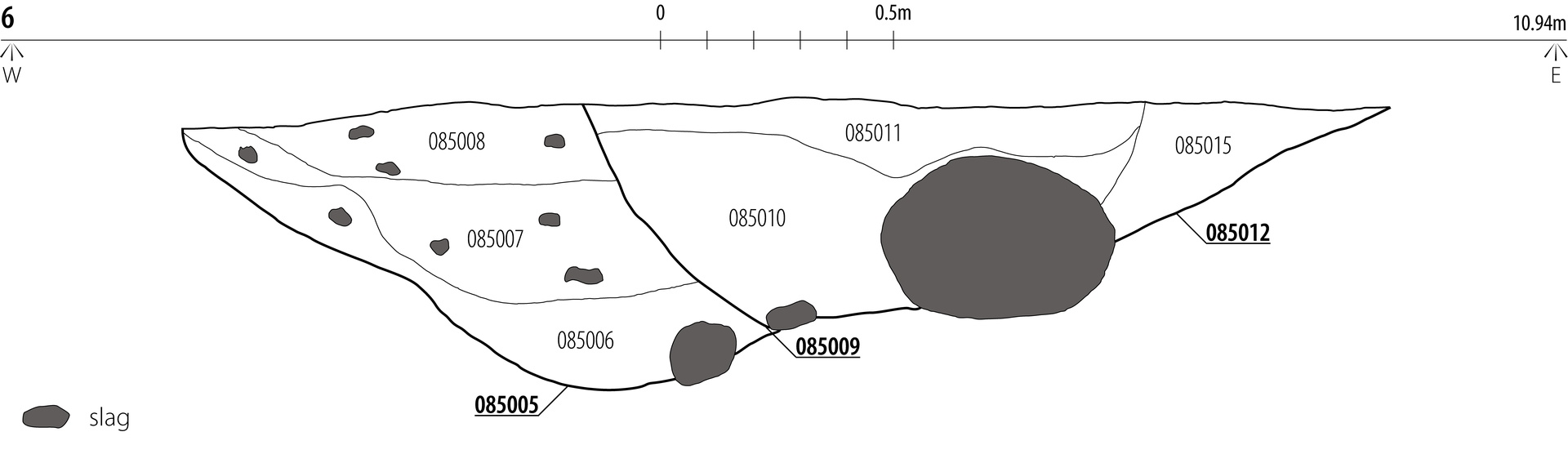
The earliest and most substantial evidence for iron smelting was identified in Trenches 85 and 86 at the south-western edge of Core Area 2 (Figure 2). Together with Trench 77, these trenches revealed a rectilinear enclosure defined by seven ditch segments and measuring approximately 85 × 35m (Figure 6). The enclosure comprised an original ditch cut, represented by slots [077013], [077007], [085012] and [086003], with re-cuts identified in [077003], [085005] and [086009], suggesting that the area was reused over time.
While pottery was largely absent from Trenches 77 and 85, ditch slots [086003] and [086009] in Trench 86 produced 197 sherds of Iron Age pottery, alongside 38 sherds broadly datable to either the Iron Age or Roman period and a single wheel-made early Roman greyware sherd. This assemblage accounted for c.12% of the total pottery weight recovered from the site and formed the second largest concentration. Identified vessel forms included jars with everted and vertical rims, scored diagonal decoration, grog-gritted fabrics and internally channelled rims (Figure 4; Table 2), consistent with middle to late Iron Age ceramic traditions (Rowlandson 2025, 67; Swain 1987, fig 46.144; Evans 1995, type Aiii). In contrast, pottery was scarce in nearby trenches, suggesting that activity within the enclosure was unevenly distributed.
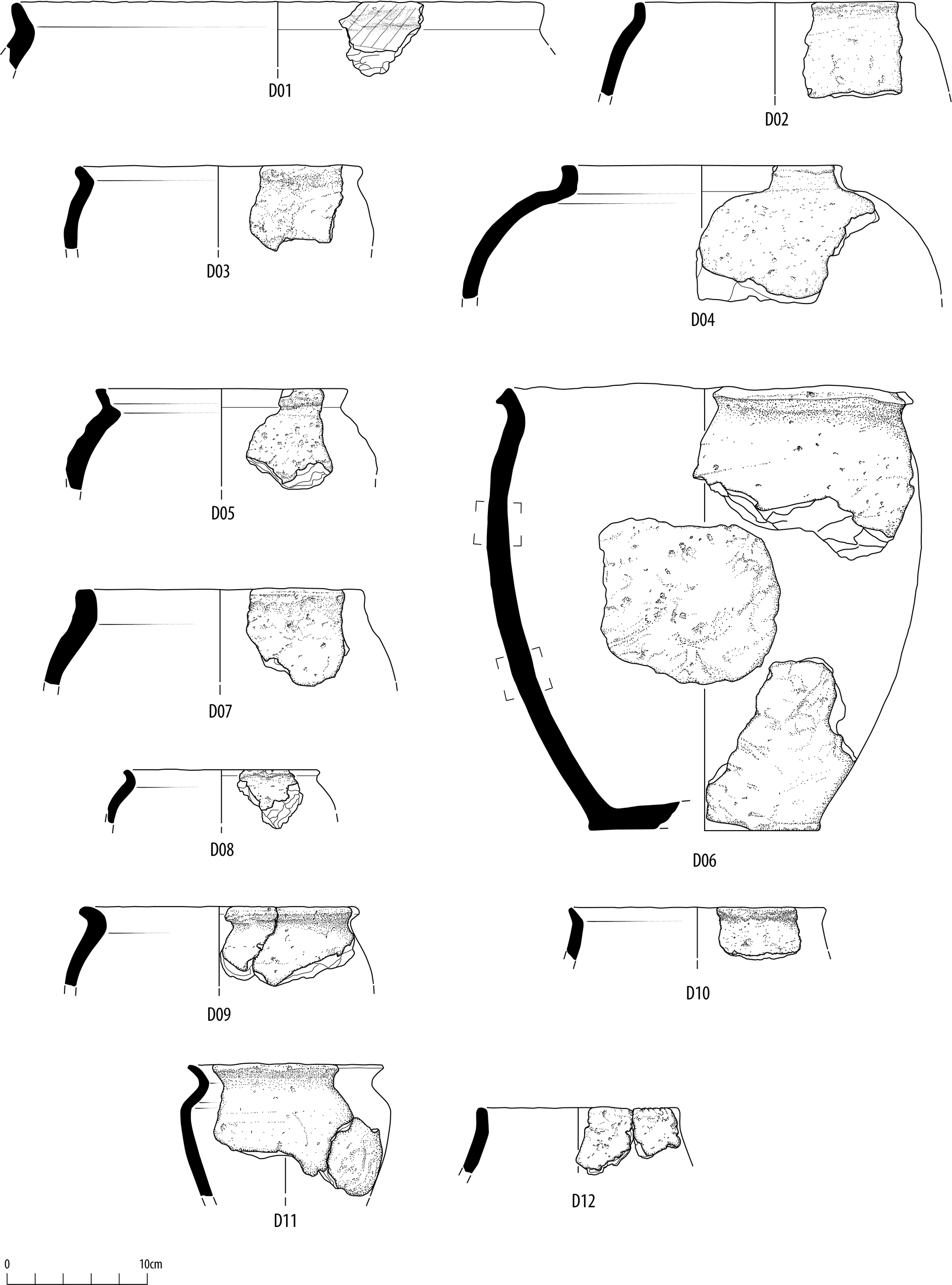
| Pottery vessel D01 ETW | Large jar with an everted rim and scored diagonal lines beneath the rim (cf. Elsdon 1996, fig.19.16.37). This type of decoration is rare on jars of this period found north of the Humber. |
| Pottery vessel D02 IASA | A 'vertical rim jar' with similar examples known from Patrington (Cumberpatch 2016, no. 141) and Creyke Beck (Didsbury n.d.). |
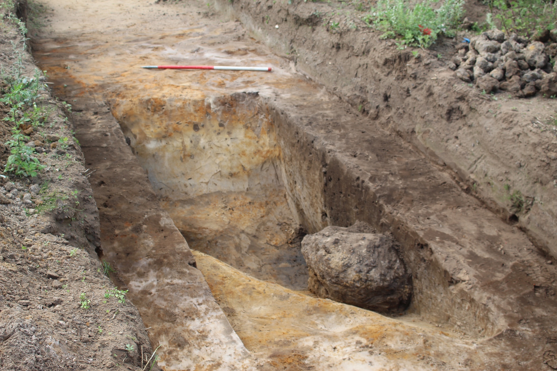
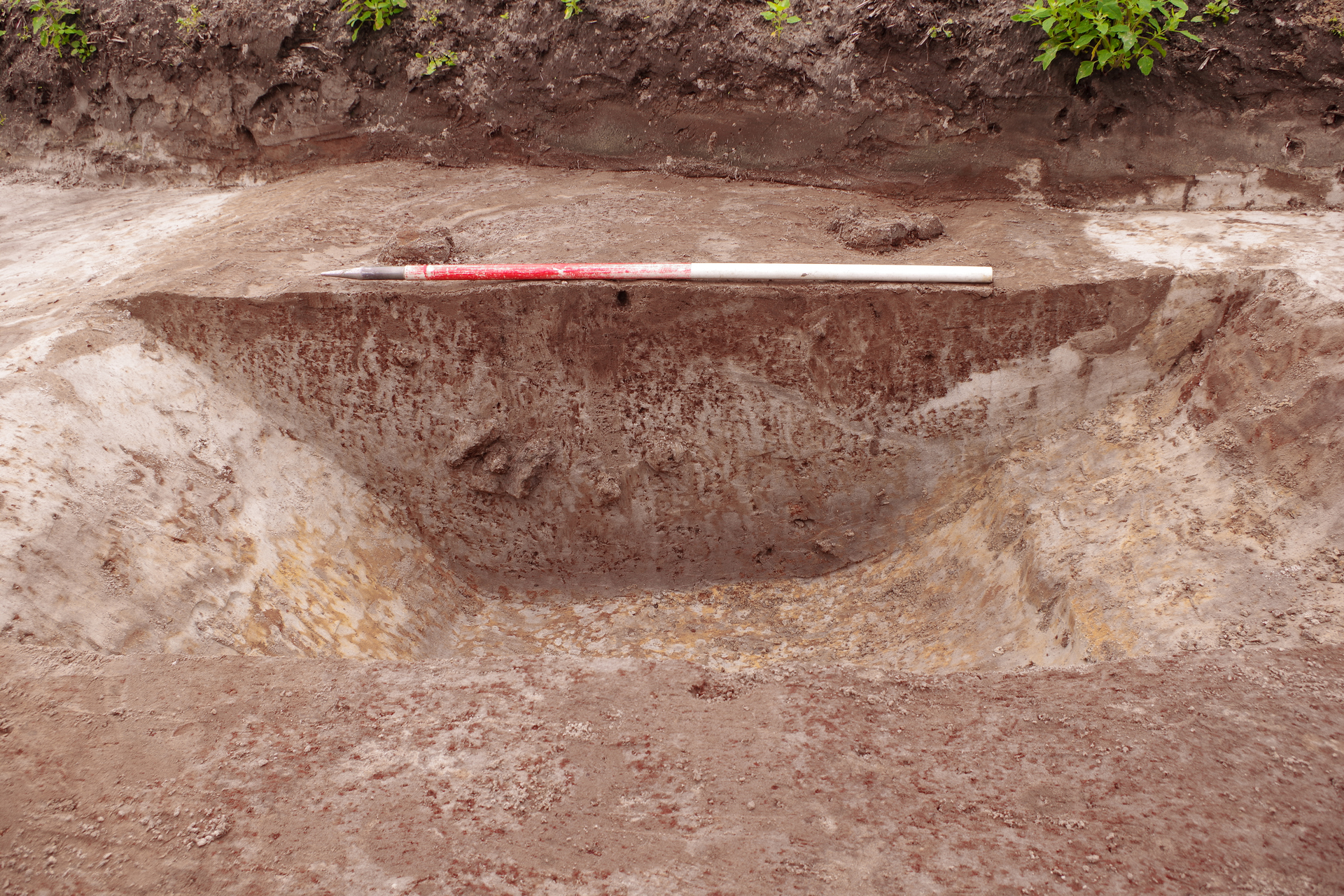
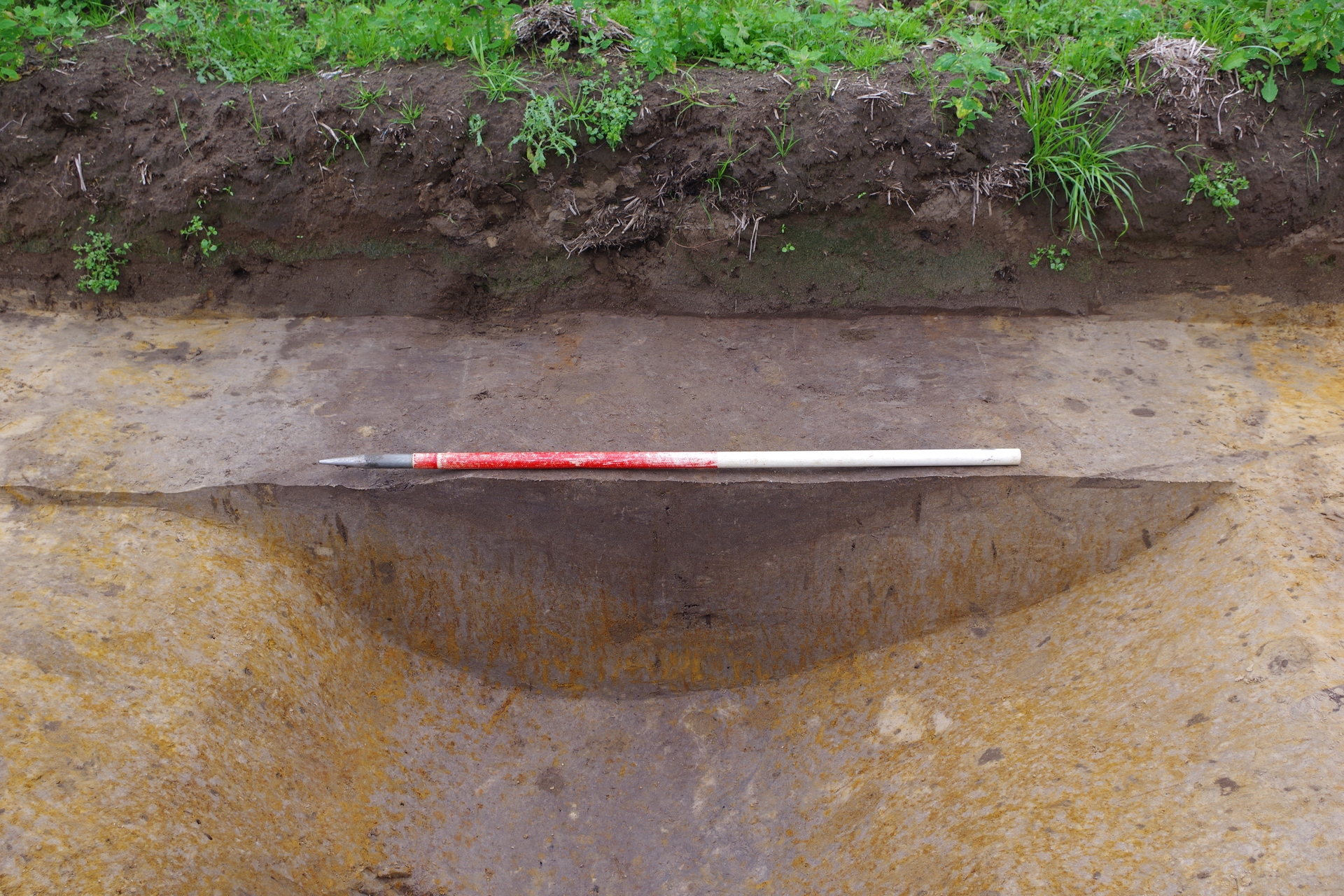
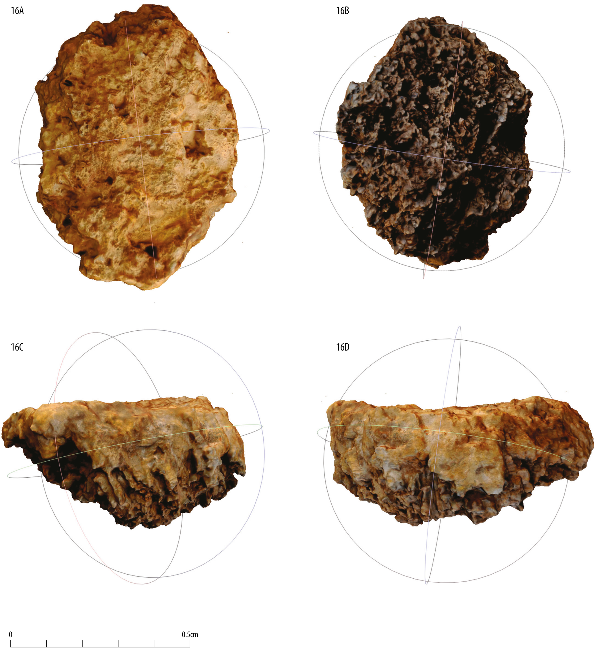
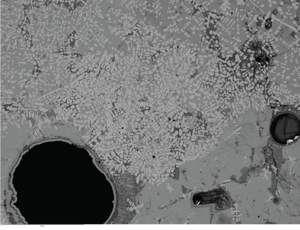
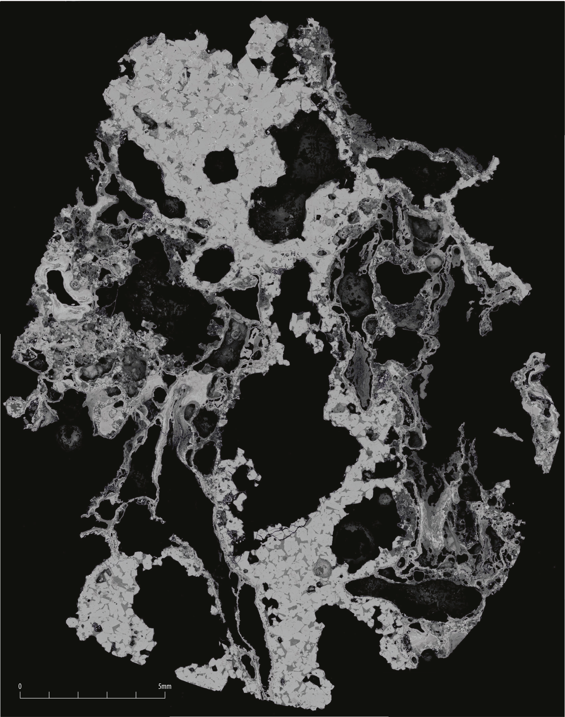
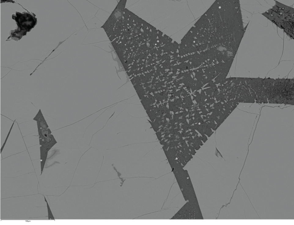
Metallurgical evidence was also abundant. Slots [086003] and [086009] in Trench 86 contained 26 fragments of iron-smelting slag (3.4kg) and a furnace wall fragment weighing 104g. In Trench 85, ditch slots [085012] and re-cut [085005] were truncated by pit [085009], which contained 14.3kg of slag, a 1.24kg furnace wall fragment, and an intact furnace bottom weighing approximately 155kg (Figures 5–7). This furnace bottom is key to interpreting the fragmented slag assemblage (Young 2025a) and is characteristic of Iron Age non-tapping iron smelting technology in which the molten waste flowed into the base of the furnace pit. Large wood moulds within the furnace bottom indicate the use of roundwood (up to 40mm diameter) as the main packing of the furnace pit. Other fragmented examples were represented by amalgamated flow slags, some containing moulds that also indicate the use of split timber (up to 70mm diameter) within the packing.
Slag associated with the furnace bottom includes freely flowed, lobed flow slags that cooled close to the furnace arch. Some fragments of this type of slag show secondary reddening and a maroon sheen indicating oxidation from air entering the furnace through the arch, producing slag closely resembling tap slag (slag that cools after draining outside the furnace), but it is unlikely that any deliberate tapping of slag was undertaken (Young 2025a).
A plano-convex block weighing 660g, resembling a smithing hearth cake, is more plausibly interpreted as dense slag formed directly beneath the iron bloom (Young 2025a) and the highest level of slag accumulation within the furnace pit.
The quantity and character of the metallurgical residue indicate that iron smelting took place in the immediate vicinity of the trenches, with heavy waste material efficiently disposed of into nearby ditches and enclosure features.
Evidence from trenches surrounding Core Area 2 indicates that iron smelting was not confined to the enclosure identified in Trenches 77, 85 and 86. Cropmark data suggest a much larger enclosure system, extending approximately 620m north–south and 650m east–west, within which Core Area 2 formed a central component. Ditches associated with this system were identified in Trenches 74, 76, 81, 98 and 67, many of which contained metallurgical residue.
Ditches in Trenches 76 and 74, located 10m and 100m north-west of Core Area 2, respectively, contained iron-smelting debris, including 286g of slag in ditch [076003] and a substantial assemblage from ditch [074003], comprising furnace bottom fragments (5.3kg), slag (514g) and furnace wall fragments (3.2kg). Further evidence was recovered from Trench 81, approximately 115m west of the core area, where ditch [081003] contained a furnace bottom fragment (220g) and 3.6kg of other smelting slag.
Trench 98, situated c.75m north-east of Core Area 2, produced three ditches, four intercutting pits and four post-holes. Although the post-holes did not form a coherent structure, associated finds included Iron Age and Roman pottery and an 828g fragment of furnace bottom from ditch [098013]. Two pits contained charcoal-rich fills indicative of nearby high-temperature activity. The charcoal assemblage was dominated by oak (Quercus sp.), which may represent either structural timber or fuel used in smelting.
Further east, Trench 67 contained ditch [067007], which produced Iron Age pottery and animal bone. One bone fragment yielded a radiocarbon date of 385–200 cal BC (95.4% probability; SUERC 129771). Although this date cannot be directly linked to specific smelting features, the spatial association with the enclosure system and the widespread presence of Iron Age material strongly suggest that iron smelting formed part of broader middle Iron Age activity across this area.
Although radiocarbon dating and finds indicate that Core Area 2 represents the earliest substantial activity on the site, evidence from Trench 1 in the far south-east suggests that ironworking may also have taken place there during the middle Iron Age. Trench 1 lies approximately 1.2km south-east of Core Area 2 (Figure 2), in an area not previously identified as an archaeological hotspot. Archaeological remains were limited to curvilinear ditch [001007/12], which appears to enclose an area with a minimum diameter of c.15m. Only a small portion of the interior was investigated, and the function of the enclosure remains uncertain. The ditch fill contained 16 fragments of ironworking slag with a combined weight of approximately 1.2kg. Notably, this assemblage represents iron smithing rather than iron smelting, making it distinct from the metallurgical evidence recorded elsewhere on site. Whilst the latter is the primary process that creates usable iron, the former is the secondary process that transforms this iron into objects. The assemblage comprised fragments of small smithing hearth cakes and preservation of this group differed from the remainder of the slag assemblage (Young 2025a, 69).
A sample of black alder charcoal (Alnus glutinosa) from fill (001011) returned a radiocarbon date of 350 cal BC (95.4% probability; SUERC-129759), overlapping with dates obtained from Core Area 2. The context also produced 10 sherds of Roman pottery, including fragments of a jar with an everted rim, a form typically dated to the later second to third centuries AD at Norton in North Yorkshire but potentially produced as early as the first century AD (Rowlandson 2025, 65). In addition, a small fragment (3g) of possible coke was recovered from the slag assemblage. Taken together, these finds present chronological difficulties. While the radiocarbon date suggests middle Iron Age activity, the pottery and possible coke fragment may indicate a later, even potentially post-medieval, phase of iron smithing, with the charcoal and pottery representing residual material. However, large-scale Iron Age smithing is known from the Vale of York between c.400 and 100 cal BC (Halkon 2020), and intrusion of later material cannot be ruled out. A second ditch [001016], located c.12m to the north-west, contained a single fragment of iron-smelting slag, offering limited additional context. In summary, while the evidence from Trench 1 suggests ironworking activity broadly contemporary with that in Core Area 2, the precise date and relationship between these activities remain uncertain.
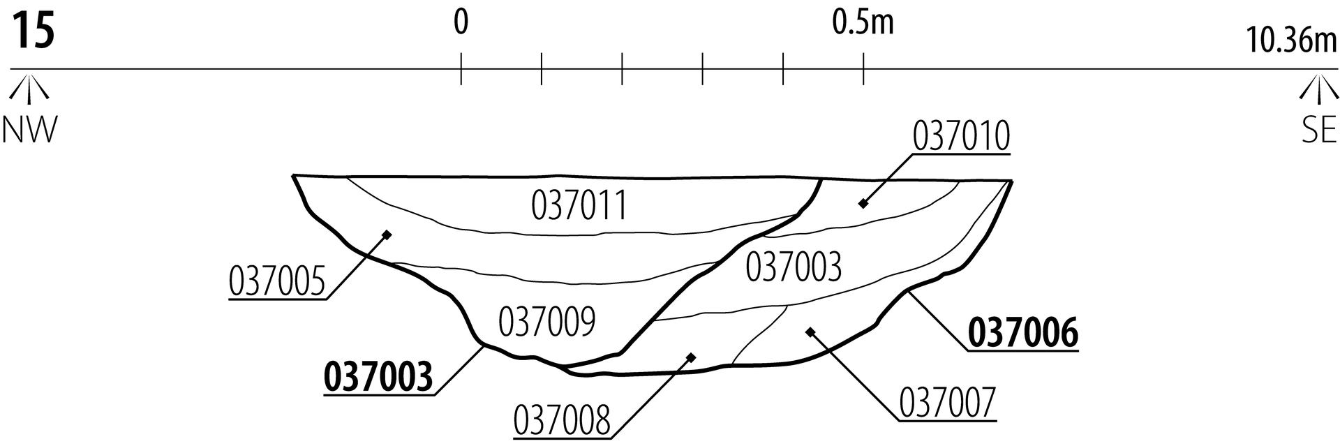
Core Area 3 was situated approximately 650m north-west of Core Area 2 and comprised 10 trenches. All but Trenches 128 and 131 contained linear features which, when considered alongside cropmark evidence and the results of the geophysical survey, indicated a north–south aligned enclosure system with a 'ladder' pattern comprising at least five enclosures (Figure 2).
The northernmost Enclosures 1 and 2 were the smallest and were defined by ditches identified in Trench 136 ([136003/08], [136006], [136010], [136013/15]) and Trench 137 ([137003], [137008]). Enclosure 1 measured approximately 30 × 50m and Enclosure 2 c.20 × 50m. Ditch [136003], a re-cut of [136006], formed the western boundary of Enclosure 1 and contained 10 fragments of iron smelting slag with a combined weight of 370g.
Approximately 25m to the east, ditch [137003] in Trench 137 formed the dividing boundary between Enclosures 1 and 2 (Figure 8). This ditch contained a 6g fragment of dark fresh flow slag with wood moulds and a 30g piece of furnace wall, alongside 17 sherds of Iron Age pottery and five sherds of Roman greyware.
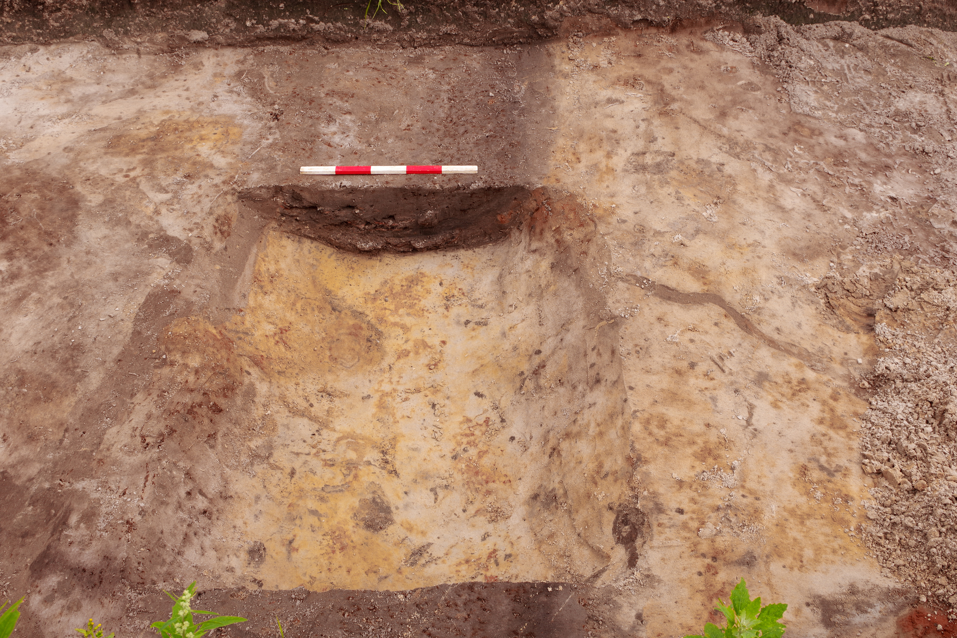
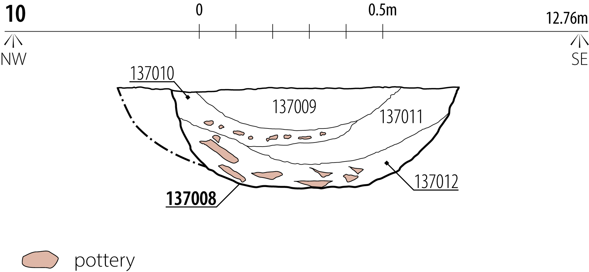
The southern boundary of Enclosure 2 was marked by ditch slot [137008] in Trench 137, measuring 0.87m wide and 0.28m deep with a shallow U-shaped profile. The ditch contained four fills representing two episodes of pottery-rich dumping separated by natural deposits (Figures 9 and 10). Primary fill (137012) consisted of mid greyish-brown coarse sand and contained 665 sherds of pottery (10.3kg), alongside cereal grains, charcoal, wetland plant species, molluscs and water flea resting eggs. The site's low-lying topography (13–14m AOD), the high groundwater levels encountered during excavation, and the presence of water flea eggs, riverine molluscs and wetland plant species indicate a long history of periodic waterlogging, potentially with a seasonal character. Similar conditions were observed elsewhere on the site, including ditch [040018] (Figure 11). The secondary fill (137011) comprised naturally accumulated, water-affected dark greyish-blue clayey coarse sand and was overlain by tertiary deposit (137010), a mid-grey coarse sand containing 442 pottery sherds (6.3kg). The upper fill (137009) had accumulated naturally and contained a further 184 sherds of pottery (2.8kg).
The pottery assemblage from [137008] is likely to date to the late Iron Age or early Roman period. No wheel-made Roman sherds were present, although some vessels display high shoulders comparable to early Roman forms (Rowlandson 2025, 68). Several vessel types were identified across the fills, including types D06–D10 in primary fill (137012), D06, D11 and D12 in tertiary fill (137010), and D04 and D05 in upper fill (137009) (Figure 4; Table 3). The quantity of pottery recovered from a relatively narrow and shallow feature is noteworthy. While pottery production or a failed firing could be considered, the range of vessel forms spans at least 400 years (Rowlandson 2025, 68). A structured deposit (Hill 1995) or the levelling of a domestic midden to infill the ditch are therefore more likely interpretations. Comparable large-scale pottery dumping has been recorded elsewhere in South Yorkshire (Chadwick 2008, 2019).
In addition to the material from Trench 137, metallurgical residue was recovered from ditch [134013] in Trench 134, c.50m south-west of Trench 137, associated with the western boundary of Enclosure 3 (Figure 2). Trench 135, located 25m south-west of Trench 134, contained two parallel east–west aligned ditches associated with Enclosure 5. Ditch [135007] (Figure 12) contained c.1.2kg of iron smelting slag, while ditch [135003] produced 103 pottery sherds, including hand-formed jars with everted rims (Figure 4; Table 3). A further ditch pair was identified in Trench 130, c.50m to the south, representing either a double-ditch or a re-cut boundary.
Additional evidence for industrial activity was identified along the eastern boundary of Enclosure 5 in Trench 132, where primary fill (132006) of ditch [132005] produced a fragment of furnace lining. A sample of indeterminate roundwood charcoal from this fill returned a radiocarbon date of 170 cal BC–cal AD 5 (95.4% probability; SUERC 129765), suggesting late Iron Age activity. A comparable date was obtained from alder charcoal recovered from primary fill (127005) of ditch [127004] in Trench 127, which returned a date of 170 cal BC (95.4% probability; SUERC 129761).
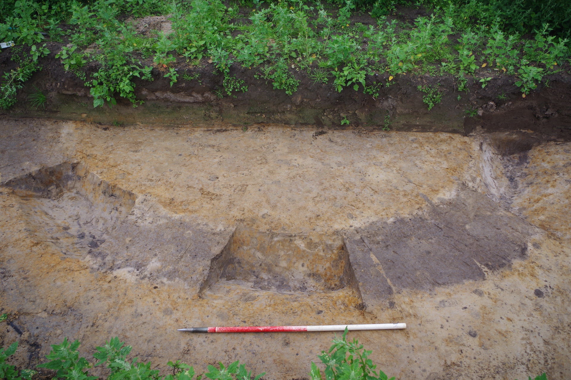
Trench 133 (Figure 2), positioned to investigate the interior of Enclosure 5 (c.145 × 50m), contained several linear features and a small curvilinear ditch [133012/10/08] enclosing an area with a minimum diameter of 3.4m (Figure 13). The single fill of this feature contained a 434g fragment of iron-smelting slag, with the fill colour likely affected by waterlogging.
In summary, Core Area 3 produced clear evidence for activity during the middle to late Iron Age. While the northern enclosures are characterised by pottery-rich deposits suggestive of domestic activity, the southern enclosures produced stronger evidence for iron smelting. Although ironworking evidence is less substantial than that recorded in Core Area 2, slag, furnace wall and furnace lining fragments were recovered from a wide area within the enclosure system. Given the distance of c.650m between Core Areas 2 and 3, a direct functional or chronological relationship should not be assumed, although relocation of industrial activity in response to changing site conditions remains a plausible interpretation.
| Vessel D04 ETW | Jar with short stubby flattened rim and a globular profile. Although difficult to align, it would appear that the vessel fits with Cumberpatch's 'vertical rim globular jar' type and could have some similarities to an unpublished globular vessel from Creyke Beck (Didsbury n.d., nos 103 and 122) and a flattened rim from Driffield Aerodrome (Challis and Harding 1975, fig.38.2). |
| Pottery vessel D05 IACV | Jar with everted, internally channelled rim. Vessel has some similarities with Rigby's 'North Dalton Jar' (2004) but is a better parallel to an example from Thorpe Thewles (Swain 1987, fig.45.62) and one from Healam Bridge that was found stratified with a vessel dated to c.100 BC–AD 100 (Cumberpatch 2017, fig.147.11). |
| Pottery vessel D06 IACV | Large jar with short externally bevelled rim. Similar to an example from the Faxfleet 'A' site (Challis and Harding 1975, fig.40.4). |
| Pottery vessel D07 IACV | Vertical rim jar with short, flattened rim similar to examples from Nuttles and Old Ellerby (Cumberpatch 2016, nos 28 and 108). |
| Pottery vessel D08 IACV | Thin-walled handmade jar with rounded everted rim, probably of late Iron Age or early Roman date (broadly as Rowlandson 2012, no. 30). |
| Pottery vessel D09 IASST | Everted rim similar to Rigby's 'Everted rim globular jar' type (2004). This type is ubiquitous amongst groups within the 100 BC–AD 100 date range proposed by Rigby for her typological grouping. |
| Pottery vessel D10 IASST | Jar with everted tapered rim similar to Rigby's 'Shapeless jar' type, a form considered to pre-date the Roman conquest (Rigby 2004; Challis and Harding 1975, figs 31.5 fig.39.3). |
| Pottery vessel D11 IACV | Jar with everted rim similar to Rigby's 'Pear shaped jar' typological group which is suggested to date to 100 BC–AD 200 (2004; see also Cumberpatch 2016, no. 115). The vessel had a thick internal carbonised deposit. |
| Pottery vessel D12 IACV | A jar with funnel-like profile (broadly as Rowlandson 2012, nos 14, 18 and 53). The vessel has a slashed rim tip of a type sometimes seen in earlier Iron Age assemblages (e.g. decoration seen at Staple Howe; Brewster 1963, fig.57.2; Rigby 2004, fig.77.99). |
| Pottery vessel D03 IACV | A jar with an everted rim and external carbonised deposits. This vessel is similar to Cumberpatch's 'wedge-rim globular jar' type (2016, broadly no. 69 and no. 76). A ubiquitous type amongst assemblages from the late Iron Age and early Roman period in eastern Yorkshire and Lincolnshire (broadly Didsbury 2004, nos 105 and 107; Elsdon 1996, Type 20). |
Approximately 55m north of Core Area 3, Trench 219 contained ditch [219003], which formed part of the same enclosure system as those identified in Trenches 136 and 137 (Figure 2). The primary fill (219010) contained 53 sherds of Iron Age pottery alongside three charred cereal grains, including oat (Avena sp.), hulled barley (Hordeum vulgare) and spelt (cf. Triticum spelta). An intrusive sherd of late second–third-century AD pottery was also present. The upper fill (219008) contained c.7.3kg of iron smelting slag, suggesting later disturbance or reuse of the feature.
Further elements of the enclosure system were identified in Trenches 212 and 208, located approximately 60m and 125m north-west of Core Area 3, respectively. Ditches in Trench 212 contained small quantities of iron smelting slag (120g). Although no artefacts were recovered from the ditches in Trench 208, a sample from secondary fill (208019) of ditch [208011] contained dark grey clayey silt with abundant organic material. A sample of alder charcoal from this fill returned a radiocarbon date of 350 cal BC (95.4% probability; SUERC 129766), refining the Iron Age date suggested by pottery from Trenches 219 and 137.
Trench 123, situated approximately 50m south of Core Area 3, contained two ditches ([123010] and [123012]) whose primary fills produced a combined total of 1.3kg of iron-smelting slag, together with small quantities of Iron Age pottery and fired clay. A further 2.2kg of smelting slag was recovered from Trenches 118, 119 and 120, immediately to the south of Core Area 3.
Primary fill (123011) of ditch [123010] contained 47.9g of charcoal, including 12 fragments of alder (Alnus sp.). One alder fragment returned a radiocarbon date of 380–200 cal BC (95.4% probability; SUERC 129760), indicating iron-smelting activity during the middle Iron Age. Other charcoal taxa present included hazel (Corylus avellana), blackthorn (Prunus spinosa), oak and members of the Maloideae, including hawthorn (Crataegus sp.), apple (Malus sp.), pear (Pyrus sp.), rowan (Sorbus sp.), service (Sorbus torminalis) and whitebeam (Sorbus aria) (Bailey and Turner 2025, 94; Schweingruber 1990).
In summary, evidence from trenches surrounding Core Area 3 indicates that both industrial and domestic activity extended beyond the core enclosure system during the middle to late Iron Age. The distribution of iron smelting residue and radiocarbon dates suggests that smelting activity was more widespread than indicated by the core area alone and may have taken place over an extended period. While the evidence supports sustained Iron Age activity across this part of the site, the function and intensity of use varied spatially.
Core Areas 4 and 5 were closely related and situated approximately 400m west of Core Area 3 (Figure 2). Cropmark and geophysical evidence suggested the presence of a complex enclosure system, potentially representing a settlement, characterised by a partial double-ditched boundary and associated trackways. The core of this enclosure system measured approximately 365m north-west to south-east and 145m south-west to north-east. During the evaluation, three trenches were excavated in Core Area 4 and eight in Core Area 5. The results indicate a gradual expansion and reorganisation of the enclosure system from the late Iron Age into the Roman period, culminating in a clearly defined late Roman phase.
The earliest activity was identified in the northern part of Core Area 5. In Trench 250, several ditches represented internal enclosure divisions. Two north-west to south-east aligned ditches, [250006] and [250013], and their re-cuts flanked a trackway linking Core Areas 4 and 5. Ditch [250013] and re-cut [250012] contained five fragments of iron-smelting slag (1.3kg) and 10 sherds of Roman pottery (357g). Adjacent pit [250033] measured 1.9 × 1.37m and contained a lens of charcoal-rich material (250035), interpreted as dumped residue from a fire. A large quantity of charcoal comprised pine (Pinus sp.), followed by oak. Hazel, blackthorn, wild cherry (Prunus cf. avium) and elder (Sambucus cf. nigra) were recovered (Bailey and Turner 2025, 94–95), with a fragment of wild cherry from the secondary fill providing a radiocarbon date of 150 cal BC–cal AD 25 (95.4% probability; SUERC 129768). While the pit and adjacent ditch cannot be shown to be directly contemporary, the association of burning and iron-smelting debris suggests related activity.
Trench 238, approximately 80m north-east of Trench 250, exposed the double-ditched north-eastern boundary of the enclosure system and its re-cuts. Primary fill (238023) of one the earliest ditches [238016] had a high organic material content, and a sample of non-oak charcoal returned a radiocarbon date of 150 cal BC–cal AD 20 (95.4% probability; SUERC 129767), closely matching the date obtained from pit [250033]. Together, these dates indicate that the establishment of the enclosure system can be placed in the late Iron Age. At the opposite end of Trench 238, ditch [238003] marked a later enclosure subdivision and contained fragments of a furnace bottom (758g) and 13 pottery sherds (1.2kg) dated to the late second or third century AD. Two further pottery sherds could be placed in the Iron Age. Assuming that the furnace bottom fragment and Iron Age pottery are contemporary, it can be suggested that they are remnants of the earliest use of the enclosure. The enclosure division itself is probably contemporary with the Roman pottery, suggesting that the earliest, large enclosures were subdivided, indicating reorganisation of the enclosure system during the Roman period.
Mixed-period evidence was also recorded in Trench 243, located between Trenches 238 and 250. Ditch [243005], interpreted as a Roman subdivision of a larger late Iron Age enclosure, contained fragments of furnace bottom (2.2kg), furnace wall (562g), and Roman pottery dated to the third century AD, alongside residual Iron Age sherds. Other ditches in the trench produced a similar combination of iron-smelting residue and Roman pottery, suggesting that debris from earlier industrial activity was incorporated into later Roman features.
Further evidence for mixed activity was recovered from Trench 254 in Core Area 4 (Figure 2). Ditch [254005], representing an Iron Age enclosure boundary, contained iron-smelting slag (4.2kg) and 36 Iron Age pottery sherds (396g), alongside 31 Roman sherds (654g). Nearby ditch [254020] and pit [254016] also produced iron smelting residue (1.7kg), fragments of fired clay furnace lining and a sherd of Iron Age pottery, reinforcing the interpretation of sustained but reworked industrial activity within this part of the enclosure system.
In summary, Core Areas 4 and 5 provide evidence for late Iron Age enclosure establishment, followed by continued use and reorganisation during the Roman period. Iron smelting appears to have taken place during the initial phases of enclosure use, with later Roman activity characterised by subdivision of existing enclosures and the redeposition of earlier industrial debris.
During the Roman period, the enclosure system underwent significant reorganisation and expansion. As noted above, several larger enclosures in the northern part of Core Area 5 and the southern part of Core Area 4 were subdivided into smaller plots. In addition, the enclosure system expanded both to the north and to the south. The southern expansion was investigated through Trenches 239, 241, 244, 245 and 247, which demonstrated that the pattern of small, rectilinear plots continued southwards across Core Area 5 (Figure 2).
Most of the ditches identified within these trenches contained a single sterile natural infilling, suggesting that they were relatively short-lived features. This interpretation is supported by the absence of clear re-cuts or re-alignments, in contrast to other parts of the site where repeated ditch maintenance was evident. The results indicate that this southern zone represents one of the later phases of enclosure development, potentially dating from the third century AD onwards. Archaeological evidence from this part of the site was limited. Across all five trenches, only three residual sherds of Iron Age pottery and a single sherd of third-century AD pottery were recovered, and no environmental material was identified. This scarcity of artefacts and ecofacts makes interpretation difficult. While activities such as animal husbandry may leave limited archaeological traces, the absence of evidence for domestic occupation, food processing or industrial activity suggests that these southern enclosures were not directly associated with habitation.
Roman expansion towards the north-west of the enclosure system was investigated through Trench 251 in Core Area 4 (Figure 2). The trench was dominated by linear features representing plot boundaries, subdivisions and drainage channels, indicating continued reorganisation of the enclosed landscape during the Roman period.
Ditch [251025], which represents the northward continuation of trackway ditch [250013] in Trench 250, contained 10 sherds of third-century AD pottery (243g) and a flat sandstone slab. One face of the slab was smoothed and showed evidence of burning, although wear was insufficient to confirm its function; it may represent either a whetstone or a flooring slab (Shaffrey 2025, 68).
An environmental sample from ditch [251019], located approximately 3.2m north of ditch [251025], contained multiple lenses of charcoal-rich material. A hulled barley grain from this fill returned a radiocarbon date of cal AD 130-330 (95.4% probability; SUERC-129770), indicating activity during the middle to late Roman period. The sample contained 107 cereal grains, the highest concentration recovered from any single feature on site. Spelt wheat was the most common cereal, followed by hulled barley, including twisted lateral grains indicative of six-row hulled barley (Hordeum vulgare var. hexasticum). Oats were also present, together with a possible grain of emmer wheat (Triticum cf. dicoccum). Due to the lack of diagnostic chaff, it was not possible to establish whether the oats were cultivated (Avena sativa) or wild varieties (e.g. Avena strigosa/fatua) that may have been accidentally harvested alongside the main cereal crop. Several grains showed evidence of sprouting prior to charring, suggesting that cereals were exposed to moisture before burning. Heathland vegetation was represented by heather leaves (Calluna vulgaris), along with seeds and florets, while numerous fragments of charred peat were also identified. The peat fragments, some containing heather-type roots, indicate that turves were collected and brought to the site, likely for fuel. Heather charcoal dominated the charcoal assemblage, with smaller quantities of oak and blackthorn also present (Bailey and Turner 2025, 95–96).
Taken together, the evidence from Trench 251 suggests that this part of the enclosure system was associated with agricultural processing during the Roman period. The combination of abundant cereal remains, charcoal-rich deposits and evidence for turf use is consistent with activities such as grain drying or processing, rather than iron smelting, which appears to have ceased or shifted elsewhere by this stage.
During the Roman period, the enclosure system associated with Core Areas 4 and 5 was surrounded to the north and east by further, larger enclosures (Figure 2). Evidence relating to this wider landscape was recorded primarily in Core Area 6.
In Trench 258, located approximately 20m north of Core Area 4, ditch [258007] was identified as part of one such enclosure. The feature contained 294g of iron-smelting slag and a sherd of mid- to late second-century AD pottery, indicating continued, though limited, industrial activity during the Roman period.
A late Roman trackway was identified approximately 100m north of Trench 258. The trackway was traced over a minimum length of 355m and had an average width of approximately 6m. Although only a single sherd of Roman pottery was recovered from the trackway ditch, the feature was observed to truncate several enclosure boundaries, indicating that it represents a later phase in the development of the enclosed landscape.
The westernmost extent of the trackway was recorded in Trench 273 within Core Area 6. Additional linear features in this trench indicated the presence of three small enclosures to the south of the trackway. Ditch [273003], associated with one of these enclosures, contained 108g of iron-smelting slag, suggesting residual or small-scale industrial activity within the surrounding enclosure system. The trackway could be followed further to the north-east and was subsequently identified in Trenches 281 and 290, located approximately 150m and 300m east of Trench 273, respectively. Together, these features demonstrate the extent of Roman-period reorganisation of the landscape and the continued importance of movement routes within the enclosed area.
Evidence from Core Area 1, located in the south-eastern part of the site, contrasts with the broader pattern of activity identified elsewhere. While previous sections indicate a general chronological progression from south-east to north-west across the site, Core Area 1 produced evidence for later Roman activity that does not fit this sequence.
Cropmark, geophysical and evaluation data revealed an enclosure system comprising at least three double-ditched enclosures, identified in Trenches 26, 33, 35 and 37–40 (Figure 2 and Figure 14). The western enclosure measured approximately 65 × 85m. Its south-eastern boundary was recorded in Trench 39 ([039017]), alongside a number of additional ditches that did not correspond closely with known cropmark features. With the exception of a single small fragment of iron-smelting slag (10g), no evidence for Iron Age or earlier industrial activity was recovered from this trench. Pottery assemblages from four ditches comprised 27 sherds dated to the late second or third century AD, together with four fragments of Roman tile.
Approximately 30m to the north-east, Trench 40 exposed parts of the north-western and north-eastern boundaries of the eastern enclosure. Ditches [040018] and [040012] contained pottery dated to the late second to third century AD. North-eastern outer ditch [040005] and potential subdivision ditch [040010] both produced fragments of Roman tile. Ditch [040005] also contained 20 fragments of animal bone, belonging to an indeterminate large mammal (e.g. cow, horse), alongside non-oak charcoal and cereal grains.
The cereal assemblage from ditch [040005] was dominated by spelt wheat, with smaller quantities of oats, hulled barley and emmer. Several grains showed evidence of germination prior to charring. One cereal grain was submitted for radiocarbon dating and returned a date of cal AD 240–380 (95.4% probability; SUERC 129769). In combination with the pottery evidence, this suggests activity during the later third century AD.
The southernmost enclosure, measuring approximately 70 × 85m, was defined by ditches identified in Trenches 35, 37 and 38 (Figure 15). Trenches 35 and 37 recorded the north-eastern ([035011]) and north-western ([037003/06]) boundaries, respectively, both of which contained few finds. Trench 38 exposed the northern corner of the enclosure ([038003/05], [038015/18]). Ditch [038015], and particularly its re-cut [038018], produced a substantial pottery assemblage comprising 352 sherds (2.8kg) dated to the late second or third century AD. The re-cut also contained a small fragment of a thin, flat rotary quern made from Millstone Grit, heavily worn prior to deposition (Shaffrey 2025, 68).
In summary, Core Area 1 displays a clear late Roman signature, with activity most likely concentrated in the second half of the third century AD. The consistent presence of Roman pottery and tile suggests a close association between the enclosure system and nearby settlement, although no structural remains were identified.
While potential evidence for domestic activity was identified in a small number of trenches, the evaluation demonstrated that metalworking was the principal activity undertaken on the site. A total of 218 kg (206 objects) of archaeometallurgical material was recovered from 28 of the 333 trial trenches, with fragments of fired clay furnace lining recorded in a further three trenches. The evidence indicates that iron smithing was limited to the far south-eastern part of the site, in Trench 1, where 14 objects (1.14 kg) of metallurgical waste were recovered. Dating this smithing activity remains problematic: a radiocarbon sample suggested a middle to late Iron Age date (350 cal BC (95.4% probability; SUERC 129759)), while pottery evidence indicates a Roman date, and a small fragment of possible coke may even suggest post-medieval activity.
Evidence for iron smelting was considerably more widespread. The remaining 192 objects (218.86 kg) of metallurgical residue relate to smelting activity, with the vast majority of this weight (155 kg) represented by a single intact furnace bottom recovered from pit [085009] in Trench 85. In-depth analysis of the archaeometallurgical assemblage concluded that the slag represents residue produced by iron smelting in non-slag tapping, slag-pit furnaces employing wood pit-packing, a technique characteristic of the early to middle Iron Age (Young 2025a, 69). The same analysis indicated the use of a very rich bog iron ore with a moderate phosphate content, producing phosphoric iron.
The size and morphology of the furnace bottom suggest a process in which blooms were produced sequentially rather than as a single event, and indicate a large-scale operation requiring substantial resources of iron ore and charcoal, consistent with a communal undertaking. Comparable furnaces are known from the early and middle Iron Age of southern and south-western England, including the fourth- to second-century BC example from Tolgarrick Farm near Truro, Cornwall, which weighed approximately 100 kg (Young 2016a).
This following section summarises the analytical methods employed, sufficient to support interpretation of the results presented below. Readers are referred to the original specialist report Young (2025a) for full methodological details, reporting conventions and results, published in Thouki and van Tongeren (2025, 69–86).
Bulk chemical composition of selected archaeometallurgical residues was determined using a combination of wavelength-dispersive X-ray fluorescence (WD-XRF) and inductively coupled plasma mass spectrometry (ICP-MS). WD-XRF was used to measure major and minor elements (Si, Al, Fe, Mn, Mg, Ca, Na, K, Ti, P and S), while ICP-MS was employed to quantify 36 trace elements (Be, Sc, V, Cr, Co, Ni, Cu, Zn, Ga, Rb, Sr, Y, Zr, Nb, Mo, Sn, Cs, Ba, La, Ce, Pr, Nd, Sm, Eu, Gd, Tb, Dy, Ho, Er, Tm, Yb, Lu, Hf, Ta, Th and U). All analyses were commissioned from ChemoStrat Ltd (Welshpool, UK).
Samples for WD-XRF were ground and dried, and fused with a 50:50 lithium tetraborate/lithium metaborate (LiT/LiM) flux to produce glass discs using a Claisse M4 Fluxy automatic fused disc maker. The resulting discs were analysed using a Bruker S4 WDXRF spectrometer and calibrated against iron slag and geological reference materials. Trace-element samples for ICP-MS were prepared using an alkali fusion method (Jarvis and Jarvis 1992a, 1992b; Pearce et al. 1999) and analysed using a Thermo Scientific XSERIES 2. Analytical accuracy and precision were monitored using international rock standards and through participation in the GeoPT proficiency testing scheme. Elemental data are discussed in detail in Young (2025a).
Microstructural investigation was undertaken using analytical scanning electron microscopy (aSEM) at the School of Earth and Ocean Sciences, Cardiff University. Polished blocks were examined using a Zeiss Sigma HD Field Emission Gun Analytical Scanning Electron Microscope (aSEM), with backscattered electron photomicrographs (BSEM) employed to document microstructures and to guide microanalysis. Elemental microanalysis was carried out using energy-dispersive X-ray spectroscopy (EDS), calibrated against Astimex olivine, pyrope and magnetite standards. Area analyses were used to characterise heterogeneous materials. As these analyses are not standardised to produce totals of 100%, no correction was applied to account for variable oxidation states. Results are therefore expressed as stoichiometrically calculated, normalised oxide weight percentages. For mineral structure calculations, directly measured oxygen values were used.
Olivine, an iron–magnesium silicate mineral group with the general formula (Mg,Fe)₂SiO₄, commonly crystallises within iron-rich slags under high-temperature conditions. Olivine compositions are reported using established conventions, with iron and magnesium proportions defining the forsterite-fayalite components and minor element substitutions calculated following standard protocols. Olivine containing phosphorus values exceeding 0.03 atoms per formula unit (APFU) is classified as phosphoran fayalite (Boesenberg and Hewins 2010). Full microanalytical data and SEM imagery are presented in Young (2025a)
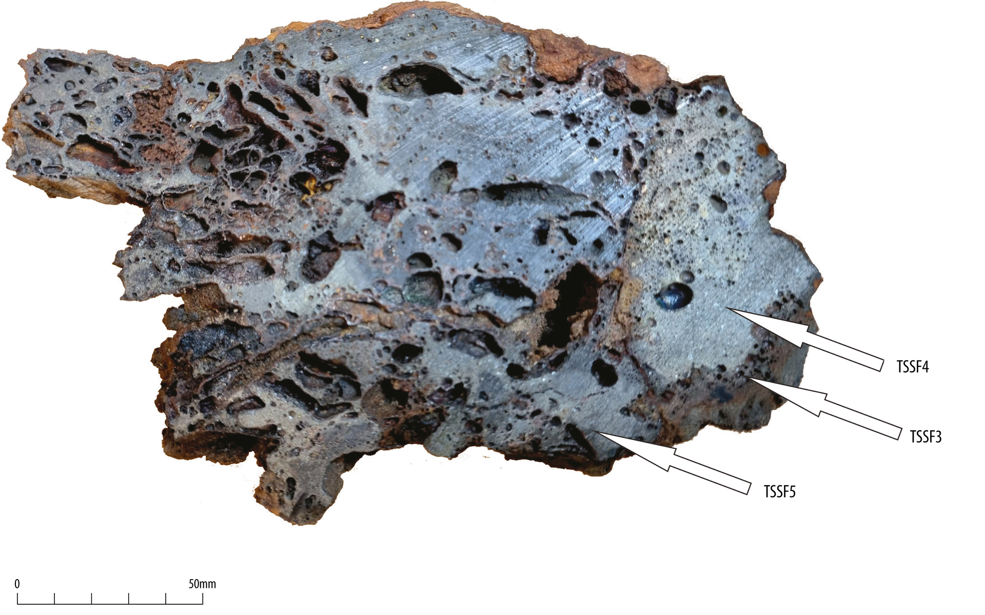
Samples were selected to represent the principal classes of smelting and associated residues present across the site, following the analytical strategy outlined in the specialist report. Two main sample suites were examined: one derived from ditch fill (074004), comprising representative examples of slag facies and furnace ceramic from closely related material, and a second drawn from pit [085009] and additional ditch contexts to examine variation between separate slag blocks and deposits (Table 4). This strategy ensured coverage of the full range of residue types while minimising disturbance to intact furnace-bottom material; detailed analytical rationale and results are presented in Young (2025a).
| Sample | Source | Elemental analysis | SEM |
|---|---|---|---|
|
Context (074004) | |||
| TSSF1 | Wall. Part of 432g piece | Y | |
| TSSF2 | Glass. Part of 432g piece | Y | |
| TSSF3 | Sliver of partially melted wall from 2850g piece | Y | |
| TSSF4 | Burr from 2850g piece | Y | |
| TSSF5 | Slag with wood from near wall 2850g piece | Y | Y |
|
Context (085009) | |||
| TSSF7 | Dense slag on wood. Part of 2485g piece | Y | |
| TSSF8 | Well lobed slag on wood. Part of 850g piece | Y | |
| TSSF9 | Free slag flows on wood. Part of 422g piece | Y | |
| TSSF11 | Charcoal rich slag. Part of 1795g piece | Y | Y |
| TSSF12 | Smithing hearth cake-like block. Part of 650g piece | Y | Y |
|
Context (238004) | |||
| TSSF6 | Dense slag with non-wetted contact, 475g piece | Y | |
|
Context (250027) | |||
| TSSF10 | Coarsely lobed slag on wood. Part of 250g piece | Y | |
The Iron Age smelting activity was represented by approximately 218kg of smelting residues recovered from 28 evaluation trenches across the site. The distribution of metallurgical residues is summarised in Table 5, which presents the quantity of smelting residues recovered by context and trench.
| Trench | Context | Weight of material per context (g) | Items per context | Combined weight of material in trench (g) | Items per trench |
|---|---|---|---|---|---|
|
1 | 001011 | 1181 *Smithing slag | 16 |
2991 | 1 |
| 001018 | 1710 | 1 | 1 | ||
| 26 | 026009 | 182 | 1 | 182 | 1 |
| 39 | 039012 | 10 | 1 | 10 | 1 |
| 74 | 074004 | 8821 | 12 | 8821 | 12 |
| 76 | 076005 | 286 | 2 | 286 | 2 |
| 81 | 081005 | 3859 | 4 | 3859 | 4 |
| 85 | 085009 | 14307 | 25 |
169307 |
26 |
| 085010 | 155000 | 1 | |||
| 86 | 086005 | 50 | 1 | 3500 | 27 |
| 086008 | 1976 | 15 | |||
| 086010 | 1474 | 11 | |||
| 98 | 098014 | 828 | 1 | 828 | 1 |
| 118 | 118016 | 260 | 10 | 260 | 10 |
| 119 | 119019 | 1380 | 1 | 1380 | 1 |
| 120 | 120008 | 565 | 6 | 565 | 6 |
| 123 | 123011 | 536 | 8 | 1372 | 10 |
| 123013 | 836 | 2 | |||
| 127 | Unstratified | 925 | 30 | 925 | 30 |
| 133 | 133013 | 434 | 1 | 434 | 1 |
| 134 | 134019 | 228 | 1 | 228 | 1 |
| 135 | 135006 | 1168 | 11 | 1168 | 11 |
| 136 | 136005 | 164 | 4 | 370 | 10 |
| 136007 | 206 | 6 | |||
| 137 | 137004 | 6 | 1 | 36 | 2 |
| 137006 | 30 | 1 | |||
| 212 | 212006 | 120 | 1 | 120 | 1 |
| 219 | 219008 | 7261 | 3 | 7261 | 3 |
| 238 | 238004 | 758 | 2 | 758 | 2 |
| 243 | 243009 | 562 | 1 | 3954 | 5 |
| 243009 | 1340 | 1 | |||
| 243009 | 848 | 1 | |||
| 243012 | 620 | 1 | |||
| 243018 | 584 | 1 | |||
| 250 | 250023 | 44 | 1 | 2536 | 8 |
| 250024 | 1176 | 2 | |||
| 250027 | 936 | 3 | |||
| 250028 | 356 | 1 | |||
| 250035 | 24 | 1 | |||
| 254 | 254007 | 4264 | 7 | 6172 | 10 |
| 254017 | 216 | 1 | |||
| 254021 | 1692 | 2 | |||
| 258 | 258008 | 294 | 1 | 294 | 1 |
| 273 | 273006 | 108 | 1 | 108 | 1 |
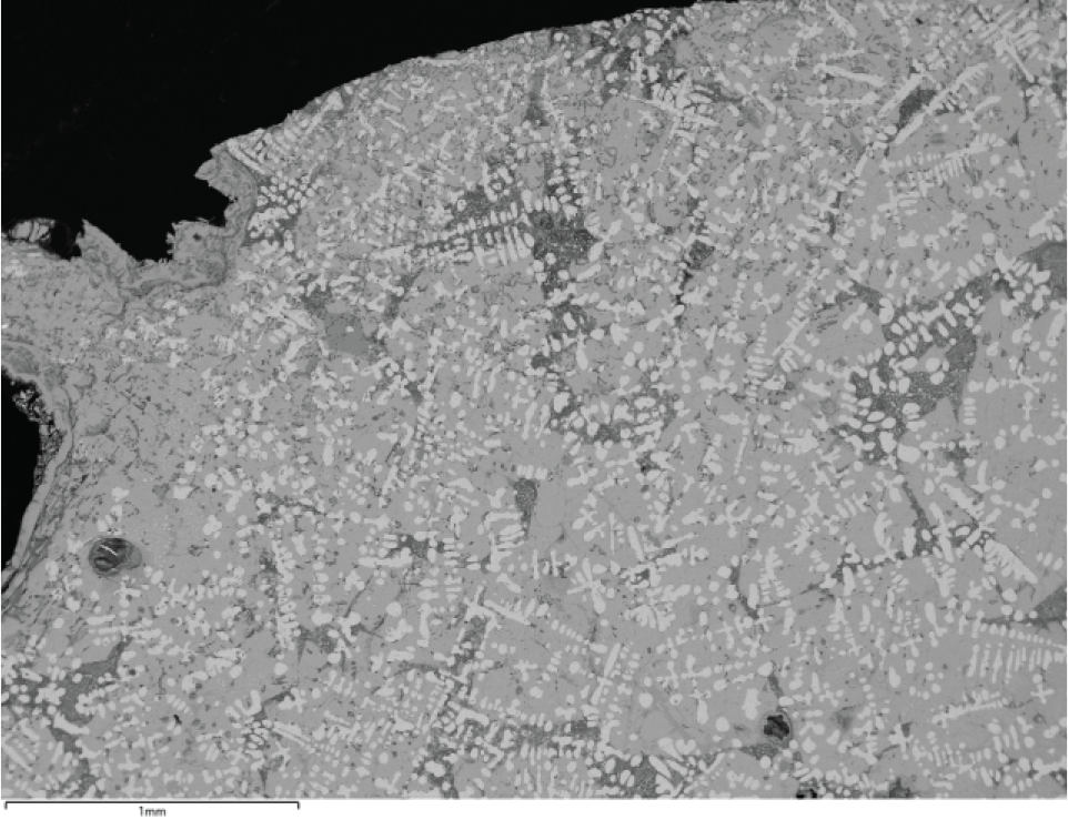
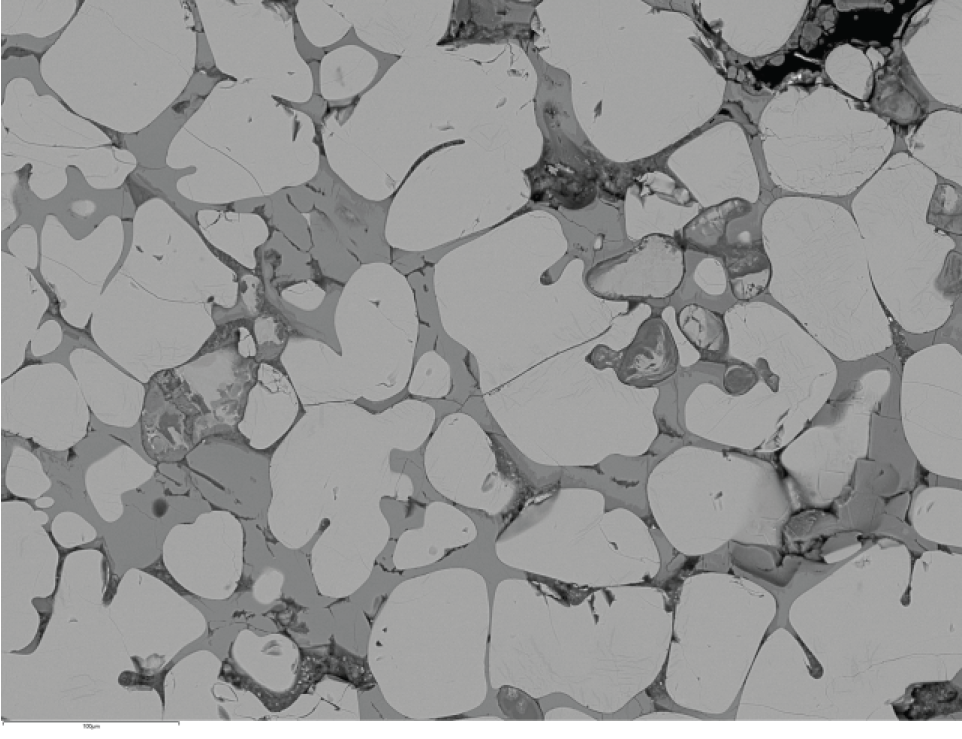
The ironworking residues recovered from the site broadly resemble those known from other early and middle Iron Age contexts. Interpretation of this assemblage is, however, greatly strengthened by the recovery of an intact furnace bottom from pit fill (085010) (Figure 7, Figure 16), which provides a rare and informative reference point for understanding how iron was smelted at the site.
Only three slag-producing contexts were radiocarbon dated. Of these, the primary fill (123011) of ditch [123010] in Trench 123 produced the most substantial group of smelting slag. An alder fragment recovered from this deposit returned a middle Iron Age date of 380–190 cal BC (95.4% probability; SUERC-129760), confirming that iron smelting was taking place on the site during this period.
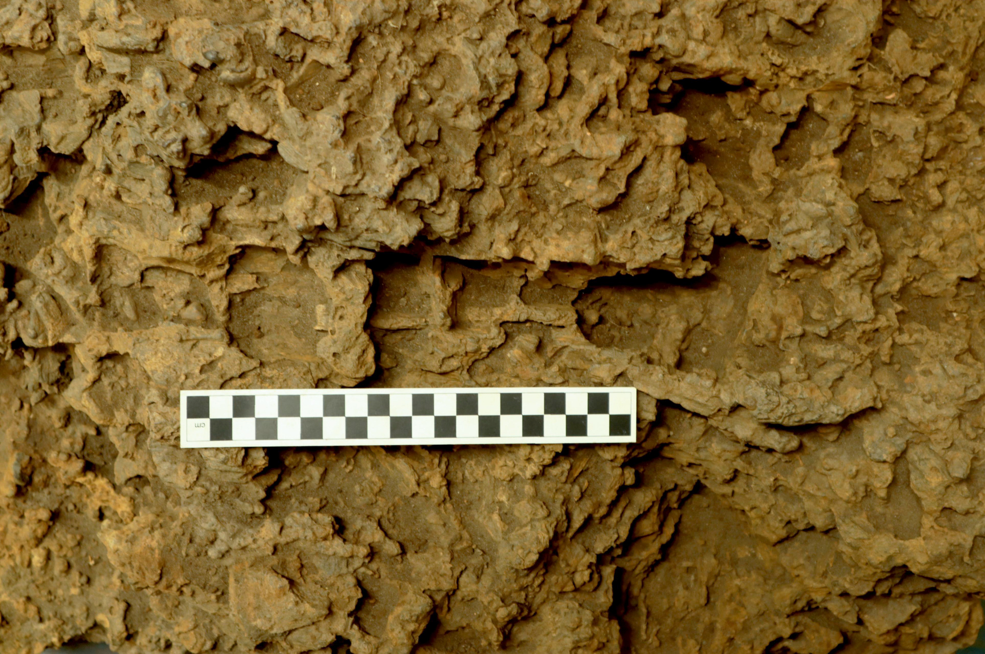
The intact furnace bottom is a substantial piece, measuring approximately 0.80 × 0.64 × 0.38m and weighing around 155kg. It preserves clear impressions of the wooden packing used, including large moulds up to 290mm long by 60mm in diameter formed by split half-round timbers (Figure 17), alongside squarer split wood elements measuring up to 140 × 35 × 40mm. These wooden components were densely packed and variably orientated: some lie horizontally across the base, while most are steeply inclined, reflecting the structure of the furnace interior. The upper surface of the furnace bottom is poorly preserved, but a probable area of contact with the iron bloom can be identified on the proximal side, measuring c.200 × 300mm. The rear (proximal) face also shows a large area where slag adhered to the pit wall, extending to about 230mm below the upper surface. The adhesion is more extensive on one side than the other, possibly indicating uneven contact with the furnace wall or localised collapse during use.
Towards the base and outer margin of the furnace bottom, slags associated with the wood packing become less fused, suggesting that the original furnace pit also contained more discrete flow slags. These are comparable to smaller slag fragments recovered from other areas of the site and help link the intact furnace bottom to the wider slag assemblage.
Almost all other iron-smelting residues recovered can be directly related to textures observed within the intact furnace bottom. The only material that initially appeared anomalous was a 660g, roughly plano-convex block from pit [085009], which resembled a smithing hearth cake. Detailed analysis of this piece (TSSF12; see below) indicated that it did not derive from blacksmithing, but instead represents dense slag formed immediately beneath the bloom during smelting.
To investigate these materials in more detail, three samples were selected for microstructural investigation: a representative flow slag from ditch fill (074004), a charcoal-rich slag from pit [085009], and the plano-convex block. The smelting slags examined (TSSF5 and TSSF11) are dominated by olivine-rich microstructures, with local chemical variation suggesting the use of iron ore with differing manganese and phosphorus contents. Wustite-rich areas within the slag indicate that some only partially-reacted ore fragments were incorporated into the molten slag. Although iron-rich particles are present, the slag matrix itself is moderately rich in silica, with feldspar forming a minor but unusual component.
The plano-convex block (TSSF12) shows a clear internal layering, with a lower zone rich in fuel particles, a central zone dominated by wustite, and a thin upper zone characterised by olivine and numerous iron prills, now largely weathered. This texture indicated formation directly beneath the iron bloom within the furnace. The composition of the fayalite points to high-temperature conditions, while the limited enrichment in manganese suggests a composition closer to that of the original ore, than that seen in the bulk slag.
As noted above, detailed microstructural analysis was undertaken on three representative smelting-related samples (TSSF5, TSSF11 and TSSF12) from contrasting contexts (Tables 4 and 5). These allow comparison between typical flow slags, charcoal-rich slags and a plano-convex slag block previously interpreted as smithing debris, providing insight into ore composition, furnace conditions and slag formation beneath the bloom. Detailed results are presented in Young (2025a).
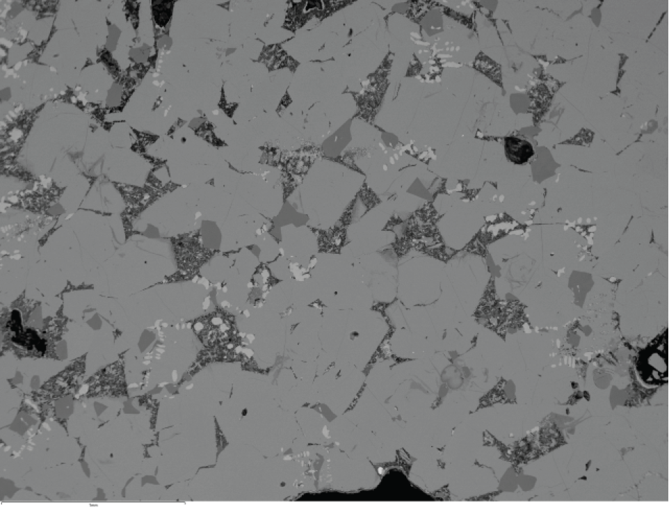
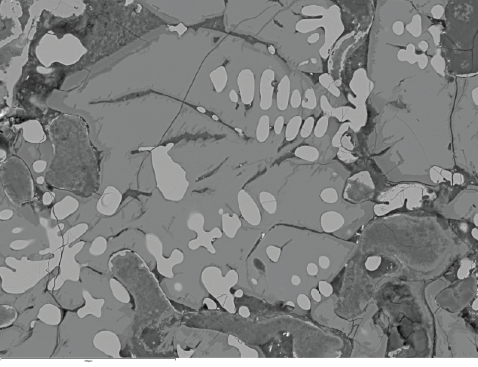
This sub-sample was taken from amalgamated flow slags with wood moulds, close to the pit wall, from a 2850g block recovered from ditch fill (074004). The same block was also sub-sampled for TSSF3 (partially melted wall) and TSSF4 (part of the burr) (Figure 18). Bulk analysis of another sub-sample of TSSF5 plots within the wustite field on the FeO–SiO₂–Al₂O₃ ternary diagram (Figure 26).
The SEM mount displays a heterogeneous texture (Figure 19), bounded on three sides by zones representing the margins of former porosity, including vesicles and wood moulds, and locally by contact with sediment (Figure 26, lower left). Coarse porosity is present, with pores up to approximately 5mm across.
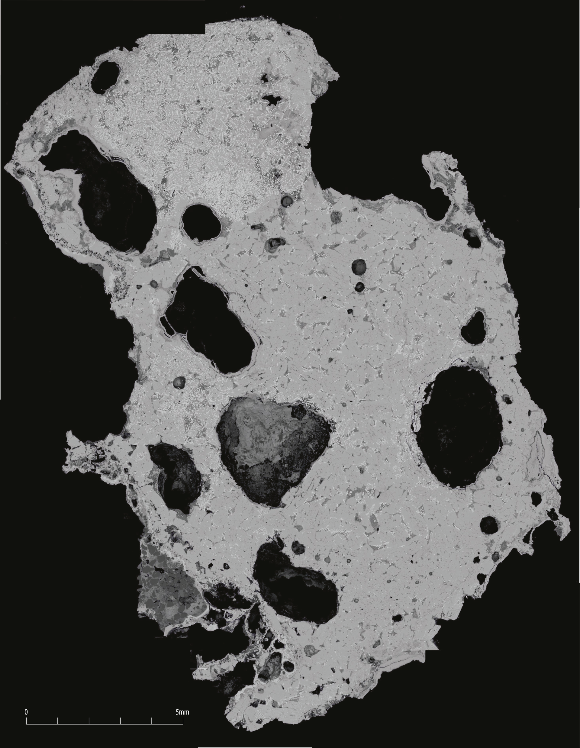
In the upper part of the mount, wustite occurs as coarse dendritic arrays (Figure 20a–e), defining a zone approximately 6mm across and suggestive of a partly assimilated former ore particle. Elsewhere (Figure 20e–h), wustite is less abundant and occurs mainly interstitial to the principal mineral phase, a relatively coarse-grained olivine with slightly elongate crystals 1–2mm across. This olivine typically follows a low-volume primary wustite and locally displays minor cotectic wustite at crystal margins.
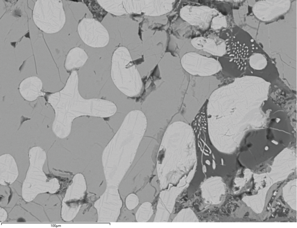
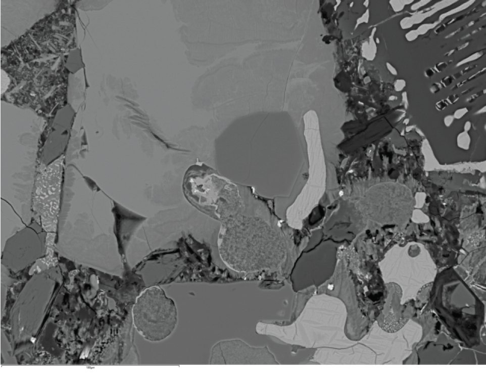
The olivine is close to end-member fayalite (Fa96Fo4 to Fa100) (Figure 21: dark blue symbols), with elevated manganese substitution (2.5% at Fa96, decreasing to 2% at Fa99Fo1) and calcium enrichment, particularly near Fa100, where substitution increases up to 8% on crystal margins. Less iron-rich olivine occurs in areas with lower wustite density and is commonly associated with altered metallic iron prills (Figure 20f) and localised olivine–wustite cotectic (Figure 20h).
Areas interstitial to the olivine (Figure 20 b,c,d,f,h) show a complex texture comprising calcic olivine (some reaching almost to end member kirschsteinite), apatite, hercynite (4–8% magnetite), iron sulphide and sodium-rich plagioclase feldspar. Two phosphate minerals (apatites) appear to be present: one iron-bearing and one sodium-rich. Near vesicle margins, the assemblage becomes locally enriched in hercynite, occurring as a cotectic with the outer part of the main olivine, together with an interstitial leucite–wustite cotectic.
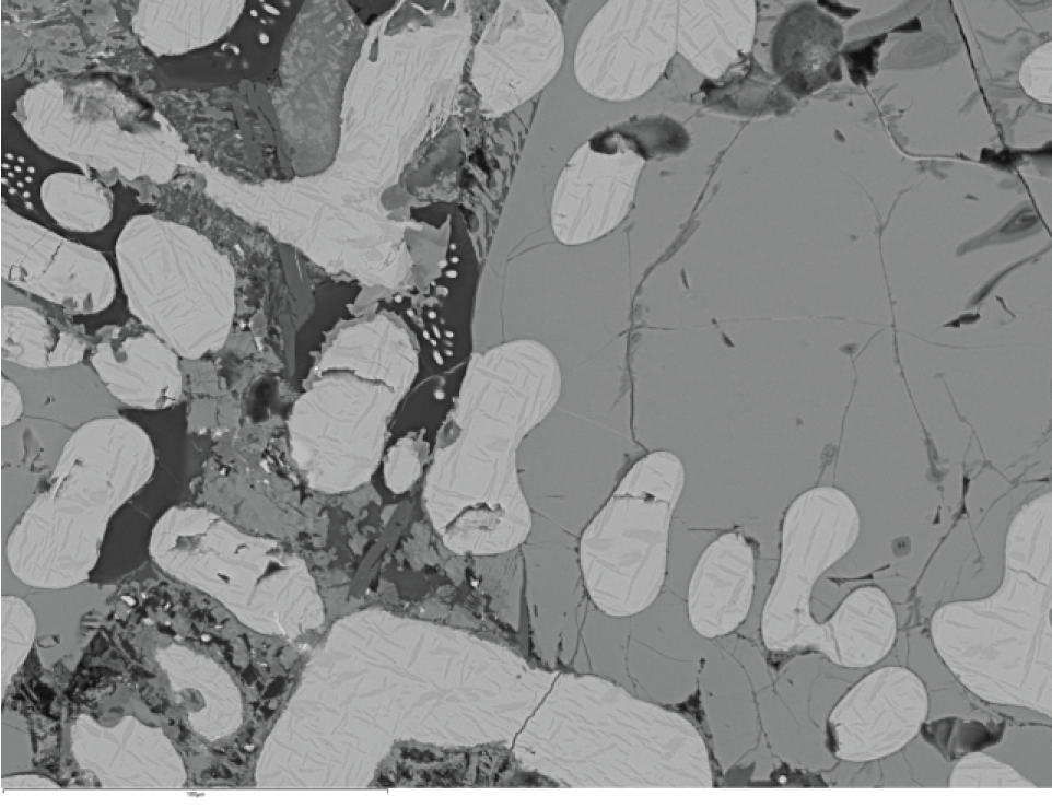
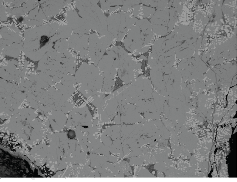
This sample was taken from a charcoal-rich slag recovered from pit [085009]. The bulk composition of a separate sub-sample plots centrally within the fayalite field on the FeO–SiO₂–Al₂O₃ ternary diagram (Figure 26). The SEM mount shows islands of slag linked by thin sheets dominated by slag and iron oxide, which probably originally contained substantial metallic iron (Figure 22).
Primary wustite is present in minor amounts; however, the slag is dominated by equant olivine (200–300µm), locally associated with large cotectic hercynite grains, within a fine-grained matrix (Figure 23). The main-phase olivine is compositionally similar to that in TSSF5, but within a narrower range (Fa97.5–Fa100), with calcium substitution up to 2.7% and manganese substitution of 2.4–1.4% (Figure 21: orange symbols). Hercynite contains approximately 8% magnetite end-member.
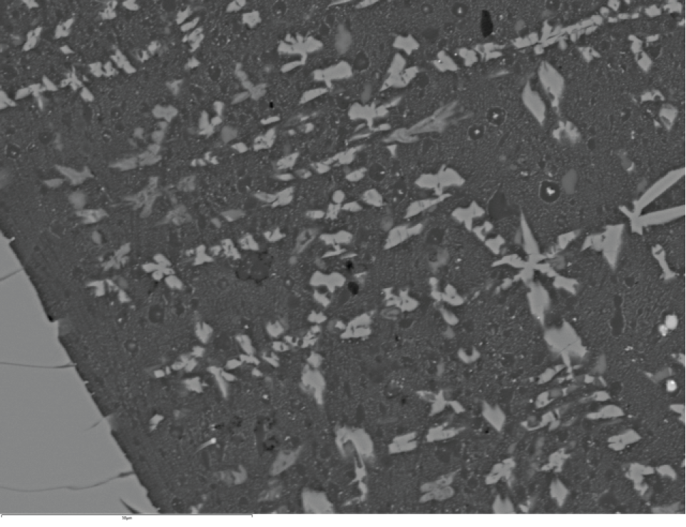
Some areas interstitial to the olivine (e.g. Figure 23b) show a complex microstructure with a mineralogy similar to that in TSSF5, with a high proportion of plagioclase feldspar. In many areas, however, the interstitial material is too fine for single-crystal analysis (Figure 23d) and includes late-stage olivine dendrites. The finer components comprise very small crystallites set in glass, with 'clear' areas around some grains. Mixed analyses tentatively suggest iron sulphide cores surrounded by iron-depleted zones taking on a composition that is feldspathic, although the material is more likely glass than crystalline.
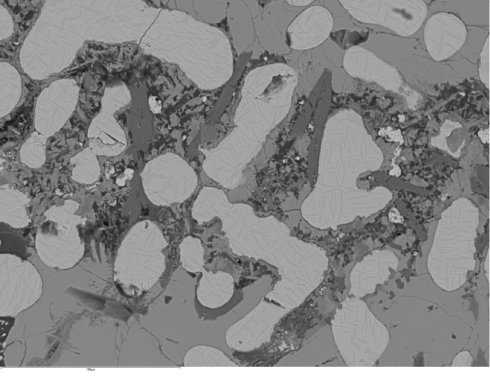
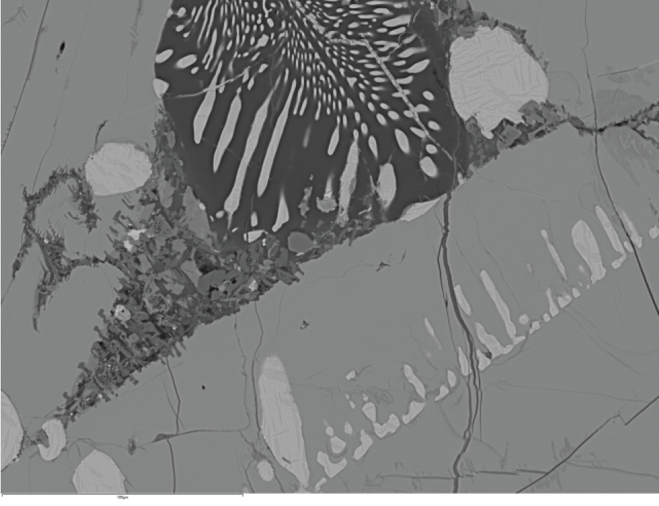
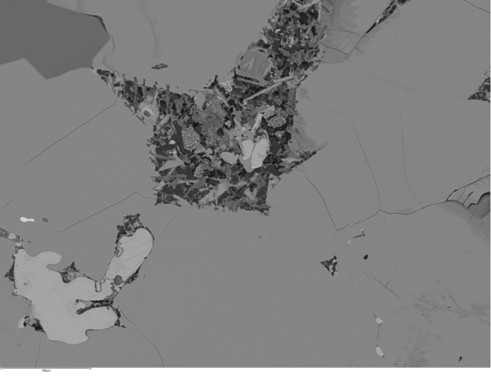
This sample was taken from a 660g smithing hearth cake-like block recovered from pit [085009]. The bulk composition is iron-rich, and analysis of another sub-sample plots well within the wustite field on the FeO–SiO₂–Al₂O₃ ternary diagram (Figure 26).
The SEM mount (Figure 24) shows a central wustite-rich zone flanked by more siliceous material to the right (representing the original top of the sample) and an iron-oxide-rich zone bearing sand grains to the left, possibly representing a void after a fuel particle.
The siliceous zone, with moderate wustite content (Figure 25c-d), shows evidence for the former presence of substantial metallic iron, now weathered (areas 4 and 6). Olivine in this zone (Figure 21: blue and yellow symbols) is broadly similar in composition to that in TSSF5 and TSSF11, but with lower manganese contents and highly variable, often elevated, phosphorus contents. Compositions range from Fa97.5 to Fa100, with typical calcium substitution of 1.8–2.5%, but locally up to 4.1%. Elevated calcium values correlate with high phosphorus, possibly reflecting unresolved apatite inclusions rather than true olivine compositional variation. Phosphorus substitution without anomalously high calcium ranges from 0.5 to 3.4%, with the upper end just classifiable as phosphoran olivine. Manganese substitution ranges from 2.0 to 1.5%.
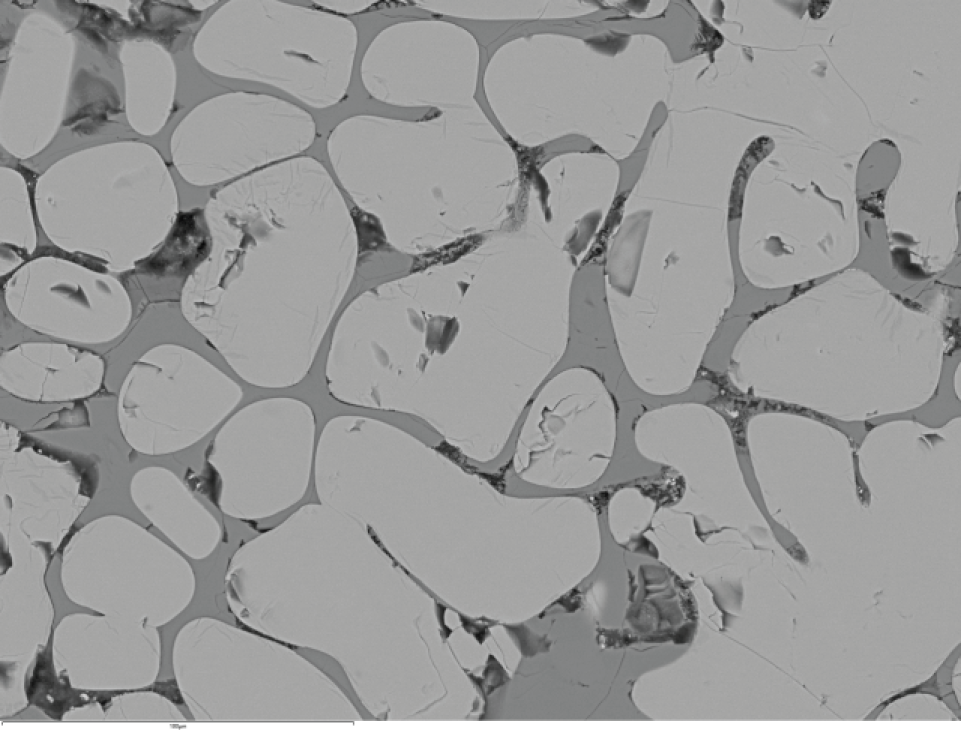
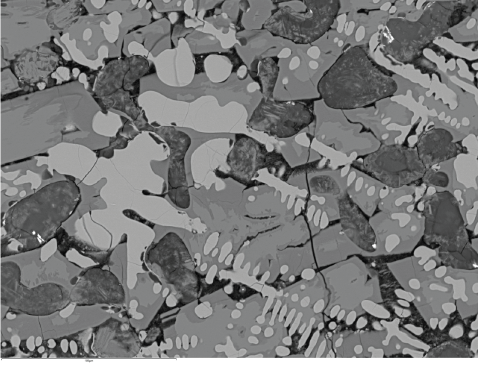
Within areas 3 and 7 of the wustite-dominated core (Figure 25a-b), olivine is slightly more magnesian, although still fayalitic, and lies outside the compositional range of the other smelting slags. These compositions range from Fa92Fo8 to Fa96Fo4, with 2.6–5.2% calcium substitution, 0.3–2.9% phosphorus substitution and 1.4–0.8% manganese substitution (Figure 21: grey and green symbols). The sample exhibits a high degree of weathering, probably reflecting the large quantity of metallic iron originally present.
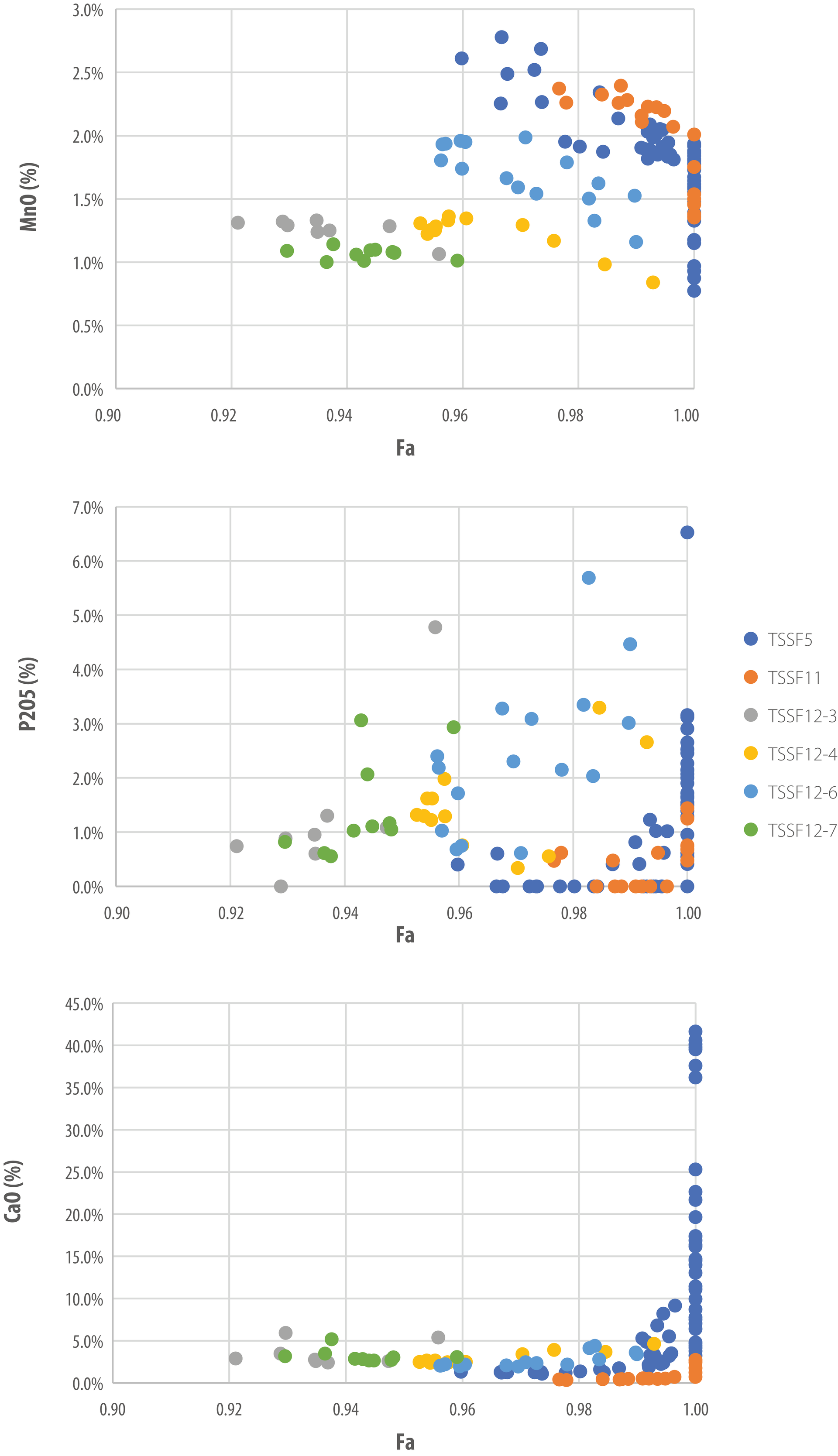
The slag samples (Table 4) show low concentrations of major elemental oxides other than SiO₂, Al₂O₃, FeO and MnO, which together comprise 94–97% of the bulk composition. This confirms that the FeO–SiO₂–Al₂O₃ ternary diagram (Figure 26) provides an appropriate representation of the major elemental system.

Overall, the system is relatively siliceous, with SiO₂/Al₂O₃ ratios of 7–12 for the confirmed smelting slags, comparable with the value of 11.6 recorded for the furnace wall sample (TSSF1). In contrast, the plano-convex cake TSSF12 has a lower ratio of 5.8, although both SiO₂ and Al₂O₃ occur at low absolute concentrations in this sample. MnO concentrations range from 1.1 to 1.7% in the confirmed smelting slags but are markedly lower (0.4%) in TSSF12. Alkalis and alkaline earths are present at generally low, but variable, concentrations. MgO reaches its highest value (1.9%) in TSSF12.
Phosphorus is present at only moderately elevated levels (0.3–0.7% P₂O₅) within the slags. Trace element concentrations are also typically low. Total rare earth element (REE) contents range from 18 to 105ppm in the confirmed smelting slags and are notably lower (9.80ppm) in TSSF12. Only barium shows consistently elevated concentrations, exceeding 1000ppm in five samples and reaching almost 4000ppm in one case, a pattern commonly associated with manganese-rich ores.
Upper crust-normalised REE profiles (Figure 27) show slight MREE (middle rare-earth elements) 'humps' superimposed on a general depletion of elements towards the light end of the group. Variations in the prominence of the MREE hump and the overall inclination of the REE pattern allow the slag samples to be divided into two groups: Group 1 (TSSF6, TSSF7, TSSF8, TSSF9, TSSF10, TSSF11) and Group 2 (TSSF4, TSSF5 and TSSF12), the latter characterised by a much weaker MREE hump. REE profiles for furnace wall-related materials (TSSF1, TSSF2, TSSF3) are comparatively flat or, in one case, (TSSF2) show a slight decline towards the heavy end of the group.
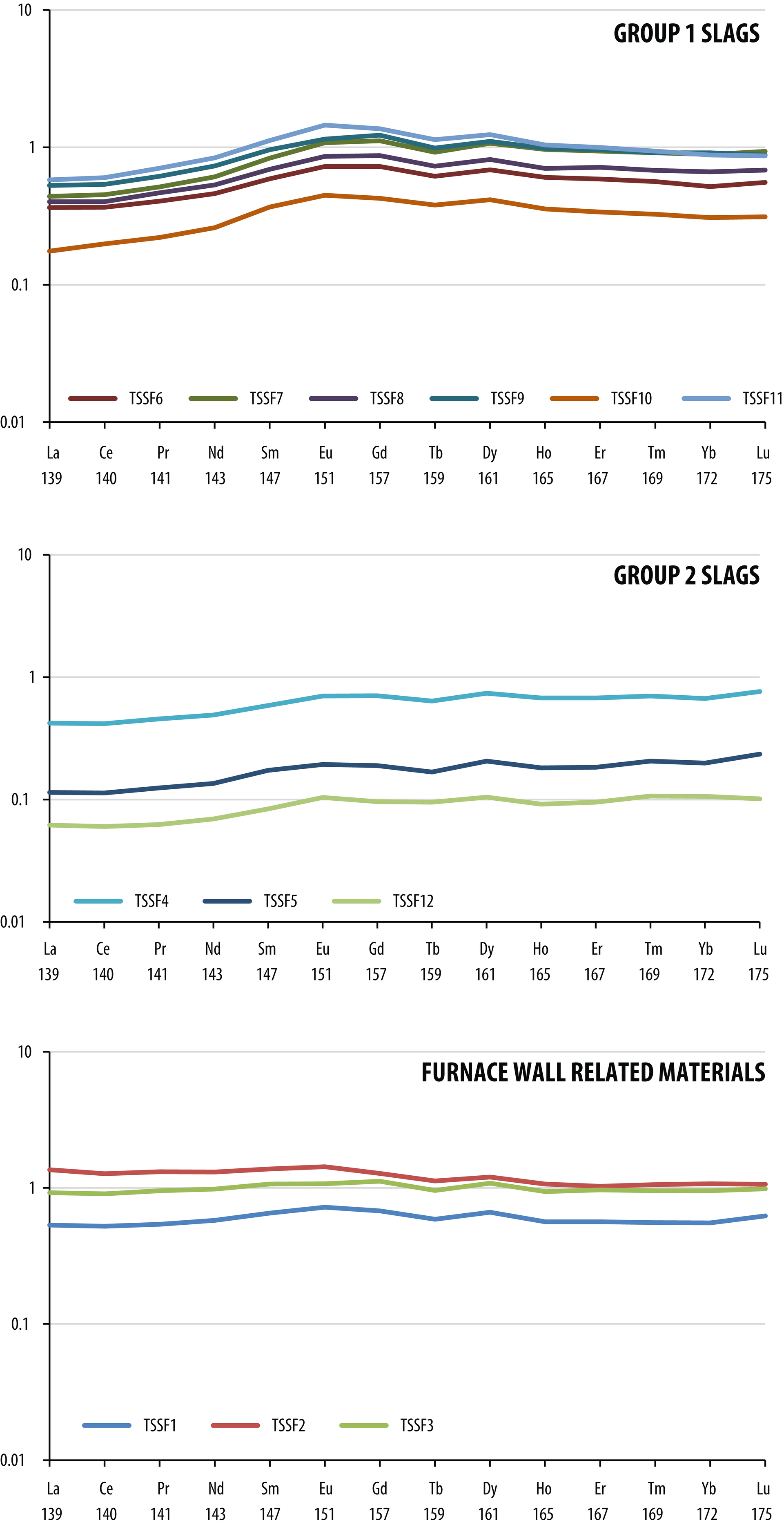
Group 2 includes smelting slag samples TSSF4 and TSSF5 from ditch fill (074004). This may indicate the use of a slightly different ore source for the smelting activities represented by waste from contexts (074004), (085009), (238004) and (250027). Alternatively, these slags may reflect a different balance between ore and furnace wall material within the smelting mixture. These possibilities are discussed further below. The REE profile for TSSF12 may be interpreted in similar terms, and the origin of this problematic piece is also discussed in detail below.
The large, intact furnace bottom shows close affinity with examples described elsewhere and lies towards the upper end of the weight spectrum identified by Young (2022). It falls between large conventional furnace bottoms, such as that from Tolgarrick Farm (Young 2016a), and the more tabular form recorded at Folly Court (Young and Anelay 2025). The presence of split- and round-wood pit-packing links the technology to iron-smelting traditions seen across northern and western Europe during the Iron Age. In Britain, its application to large furnace types characterises early and middle Iron Age iron smelting, but appears to be replaced by smaller furnace varieties in the late Iron Age.
Pit packing implies operation as a single smelt, since its function – to permit percolation of slag into the pit – would be compromised if the process were stopped and restarted. The 155kg of slag can therefore be regarded as waste from a single smelting event. The non-slag-tapping slag-pit furnace was typically used in the British Iron Age as a reusable furnace type. Slag dumps at sites such as Welham Bridge and Folly Court demonstrate that this principle applies even to the largest furnaces. Survival of a furnace bottom slag block still within a furnace likely indicates a deliberate decision not to reuse that installation, possibly due to excessive degradation of the superstructure during the smelt.
Slag compositions from Thornton (Figure 26) range from just within the wustite field (TSSF5, TSSF10) to compositions plotting centrally within the fayalite field. Detailed investigation of TSSF5 shows that it contains a partly reacted ore lump and therefore does not represent an equilibrium composition; within the purely slag components, wustite occurs only as a minor phase. Overall, the slags are relatively siliceous. This may reflect the siliceous nature of the furnace wall material (e.g. TSSF1) and/or silica present in the bog iron ore, both likely deriving from the dominantly sandy geological substrate (Figure 29).
Interpretation of the binary plots shown in Figure 28, following Young (2016c), is constrained by possible contamination of the furnace wall ceramics. Samples TSSF2 and TSSF3 show elevated alumina contents, consistent with partial melting of a more siliceous ceramic. Sample TSSF1 shows high silica and elevated iron, which may represent genuine furnace clay composition or contamination. Modelling is therefore necessarily tentative, both because of uncertainty over ceramic composition and because the samples derive from different smelts. The smelting system is defined by a tie-line (Figure 29, purple dashed line) between the furnace ceramic (sample TSSF1) and a model ore composition (indicated by open circles). The trajectory of slag evolution during iron extraction is indicated by the blue arrows. The intersection of these defines a nominal smelting mixture of 88% ore and 12% ceramic, consistent with proportions suggested by other studies.
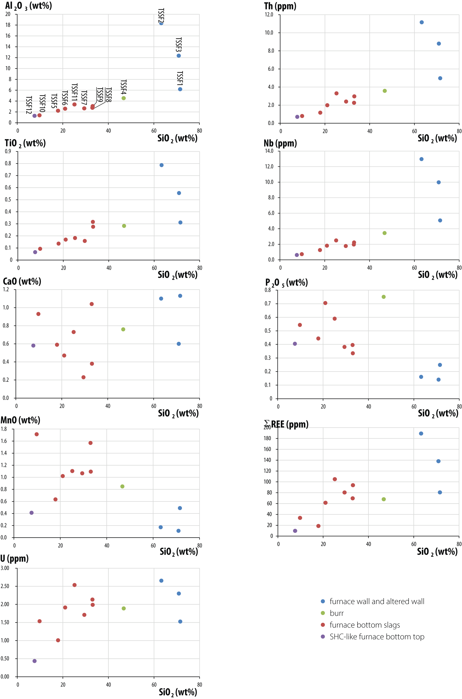
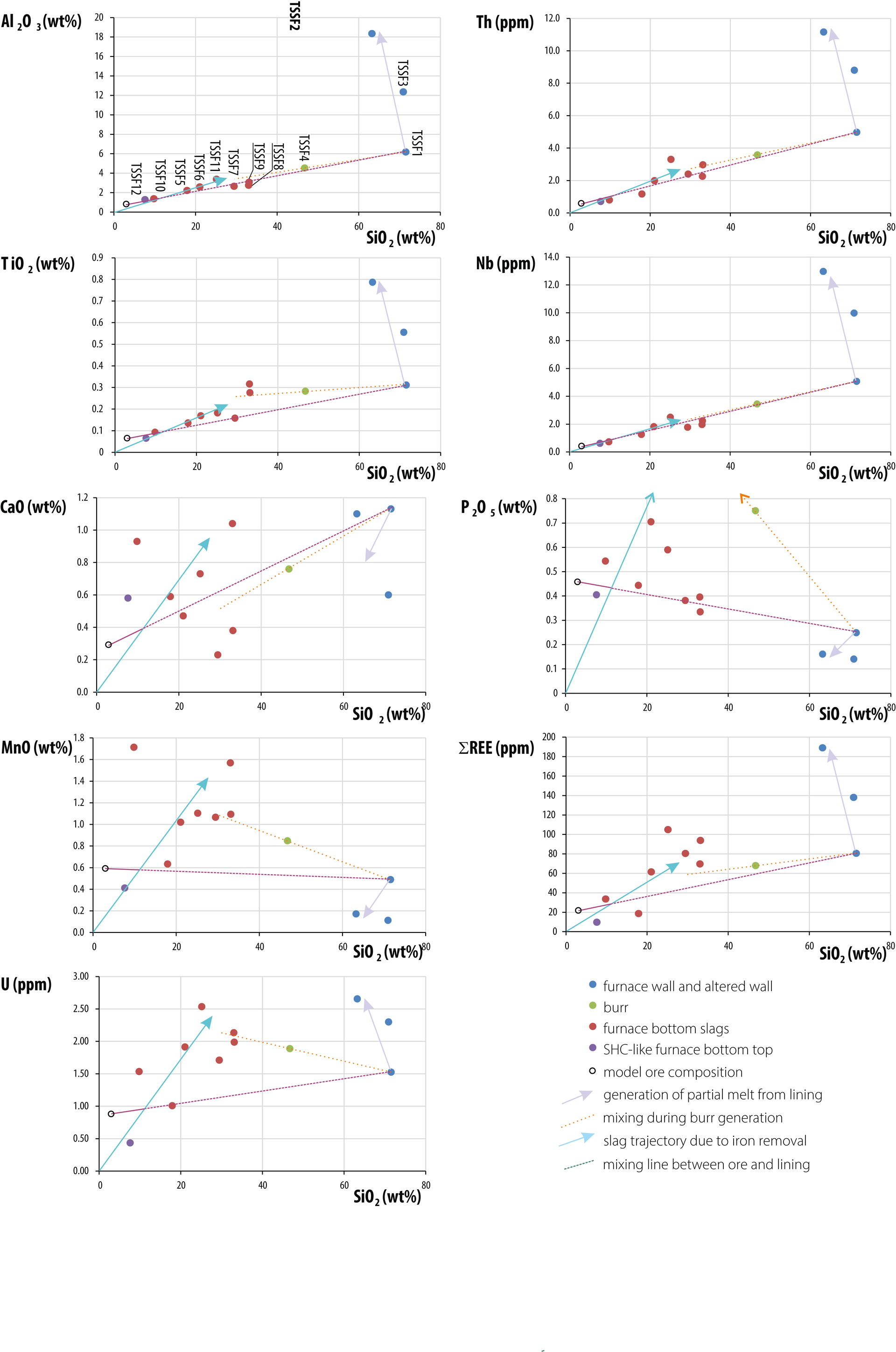
Figure 29 also shows a tentative trajectory for partial melting of the furnace wall (lilac arrow). A further tie-line (orange dashed line) extending from the ceramic composition through the burr sample (TSSF4) trends towards the most silica-rich slag compositions in most plots, suggesting formation of the burr through reaction between slag and furnace wall. In the P₂O₅–SiO₂ plot, however, data cluster close to the lining–ore tie-line, compatible with phosphorus fractionation into the metal or loss to vapour.
Data for Al₂O₃, Th, TiO₂ and Nb show slag analyses clustering close to a line between the origin and wall ceramic (TSSF1), providing poor constraint for mass-balance modelling using these species. CaO values are more scattered, probably reflecting variable uptake from fuel ash. In contrast, MnO, ΣREE and U show more coherent patterns, allowing improved estimation of mass-balance parameters. These constraints suggest an ore composition for the illustrated species as shown in Table 6, with most of the remaining composition (up to 95%) comprising iron oxide.
| SiO2 | 3% |
| Al2O3 | 0.8% |
| MnO | 0.6% |
| CaO | 0.3% |
| TiO2 | 0.06% |
| P2O5 | 0.46% |
| SREE | 22ppm |
| U | 0.9ppm |
| Most of the remainder (up to 95%) is iron oxide. | |
The tentative model implies significant enrichment (E = 2.3) of non-ferrous components in the slag (Figure 29). Under this model, 1kg of anhydrous ore would produce approximately 450g of metallic iron and 500g of slag, giving an extractive efficiency of 67%. While not all metallic iron would be incorporated into the recoverable bloom, this suggests that a 155kg slag cake could imply production of up to 140kg of iron.
Such calculations are approximate and sensitive to model assumptions. Increasing the assumed ore iron content to reduce extractive efficiency would result in many slag samples showing an implausible net gain in iron relative to the ore. Comparable calculations for other large Iron Age furnaces indicate similarly high yields. At Folly Court, Wokingham, a single smelt is estimated to have produced 86kg of iron (Young and Anelay 2025, 41).
This scale of production has important implications. Even if only part of the estimated 140kg of iron was incorporated into the bloom, such a mass would not be forgeable, or readily divisible, by hand using Iron Age smithing technology. It has therefore been proposed by Young and Anelay (2025) that large early to middle Iron Age furnaces may have produced smaller blooms sequentially, a process that requires further experimental investigation.
The scale of the operation also implies a particular social context. Operation of a furnace consuming approximately 360kg of bog ore, and likely substantially more charcoal, to produce perhaps 10 blooms requiring immediate compaction, would have required a large workforce and may represent a communal activity.
The concavo-convex dense block sampled as TSSF12 is characterised by a dense wustite zone containing relatively magnesian fayalite with lower manganese content than the other smelting slags. These features indicate high formation temperatures and a lower degree of iron extraction than is seen in typical flow slags. They are consistent with formation immediately beneath the growing bloom and are not compatible with production through smithing, despite the overall morphology of the block.
An understanding of the Thornton site is grounded in a review of the wider surrounding landscape. The radical landscape changes that occurred during the early and middle Iron Age provide a key starting point. To the north, the Yorkshire Wolds were characterised by chalk grassland suitable for animal husbandry, while the Vale of York and the Humberhead lowlands comprised fertile land favourable for arable farming. However, between c.800 and 300 BC, the East Riding of Yorkshire was affected by one or more tidal surges and rising sea levels (Halkon 2020, 33). These events led to the formation of an inlet extending northwards from the Humber estuary for approximately 12km, with a maximum width of around 3km (Halkon and Innes 2005). Coring indicates that the upper reaches of this inlet were formed by creeks (Coles 2010, 35), suggesting a water-dominated environment extending deep into the Vale of York. Wetland areas appear to have extended well beyond Pocklington and into the area around Thornton and Allerthorpe (Halkon 2020, 42, fig.1.4).
Although the precise extent of these changes is difficult to define, it is likely that this major natural shift had a profound impact on arable land within the Vale of York. As conditions changed, the landscape became increasingly suitable as a source of timber for construction and charcoal production. In addition, bog iron ore became available on a much larger scale, contributing to the development of ironworking activity within the region.
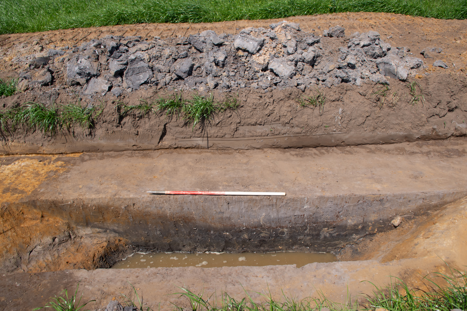
As noted previously, interaction with water was clearly evident in the excavation results. The site contained a large number of ditches, some of which functioned as enclosure boundaries or trackway edges. Many of these ditches were re-cut on one or more occasions, suggesting regular maintenance and reconfiguration, probably in response to periodic waterlogging or flooding. It is also likely that some of the shallower or double ditches were constructed for water-management purposes. Episodes of waterlogging are reflected in the colour and matrix of many ditch fills. A key example is ditch [040018] in Trench 40, which contained dark brownish-black and bluish-black silty sand fills (Figure 11).
Variation between wetter and drier areas of land on and around the site is further supported by the charcoal and plant macrofossil assemblages. Samples from mid-late Iron Age contexts were dominated by alder charcoal, with hazel, Maloideae, blackthorn and oak also regularly represented. Ash (Fraxinus excelsior) and birch (Betula sp.), both tolerant of wet conditions, were present in small quantities but were not widespread. Ash favours moist soils but is unsuitable for permanently waterlogged conditions (Bailey and Turner 2025, 96–97; Stuijts 2005, 141). It is, however, an excellent fuelwood that can burn even when green (Gale 2009; Edlin 1949), a property that may have influenced its selection.
The dominance of alder suggests extensive exploitation of wetland resources, as the species typically grows along streams and rivers, in damp woodland and in fen peatland (Bailey and Turner 2025, 97; Stuijts 2005, 139). Although alder is generally regarded as a poor fuelwood due to its softness, high moisture content and need for prolonged seasoning (Edlin 1949, 23), it produces good-quality charcoal and is commonly identified in charcoal assemblages from all periods (Bailey and Turner 2025, 97). The presence of hazel and oak indicates continued use of drier woodland resources, while Maloideae and blackthorn, typical hedgerow species, suggest areas of more open land in the vicinity.
During the late Iron Age, wetland species became less prominent, but oak, hazel and blackthorn remained widely exploited. Pine and possibly wild cherry appear for the first time, with the presence of pine being particularly notable. While the specific use of pine charcoal at Thornton remains uncertain, it has historically been preferred to oak for fuelling furnaces in silver mining, as it is easier to keep alight and less prone to smouldering (Gale and Cutler 2000, 391). Its selection at Thornton may therefore reflect similar burning properties. Pine is characteristic of transitional zones between fen woodland and raised bog (Godwin 1975) and has been recovered from contemporary regional sites, including land east of Moor Lane, Haxby, North Yorkshire (Archaeological Services Durham University 2023), a late Iron Age to Roman site, located approximately 25km north-west of Allerthorpe. Pine has also been identified in Roman deposits from York as fragments of small branch wood, leaves and bud scales (Hall et al. 1991).
A waterlogged plant assemblage dating to the first half of the Roman period suggests the presence of open woodland. Species such as bramble (Rubus fruticosus), nipplewort (Lapsana communis), rough chervil (Chaerophyllum temulum) and hedge parsley (Torilis japonica) are typical of woodland margins and hedgerows. Alder seeds, twigs and catkins again indicate a locally high water table. Wetland and fen species, including wild celery (Apium graveolens), meadowsweet (Filipendula ulmaria), sedge (Carex sp.) and rush (Juncus sp.), suggest generally damp to wet conditions associated with poor drainage. Although meadowsweet is characteristic of wet environments, it does not tolerate prolonged waterlogging, pointing to periodic rather than sustained saturation. This may reflect wet grassland or marginal vegetation within damp woodland edges. The presence of cross-leaved heather leaves, together with rush, sedge and meadowsweet, may indicate a transitional zone between fen carr woodland and wet heathland (Bailey and Turner 2025, 97).
In the second half of the Roman period, the charcoal assemblage differs markedly from earlier phases. Heather charcoal becomes dominant and charred peat fragments are frequently recorded. This pattern is unlikely to reflect a decline in woodland resources and instead suggests the deliberate collection of heather or turves for specific purposes (Bailey and Turner 2025, 97). The abundance of heather indicates active exploitation of local heathland. Charred peat may represent turves or peat blocks brought to site, while the presence of heather leaves and florets suggests that above-ground material was also collected. Although peat is often used as an alternative fuel where firewood is scarce, its use at Thornton does not necessarily imply woodland depletion, as other wood taxa remain present. Heather was a highly versatile resource, historically used for fuel, construction, bedding, furnishing, broom making and dye production, and continues to be used as thatch today (Edlin 1949, 117; Kenicer 2020, 136). It is therefore likely that heather was gathered locally for one or more of these purposes.
Against the backdrop of these landscape changes, middle Iron Age communities adapted their ways of life. Hilltop locations, particularly on the Yorkshire Wolds, became favoured places of habitation, leading to the development of so-called 'ladder settlements'. In contrast, the lowlands to the south and west were characterised by single rectilinear enclosures and open settlements comprising groups of roundhouses with broad ring-gullies (Halkon 2020, 39). The lowlands, especially the area around the River Foulness, also saw increased metalworking activity (Halkon 2020, fig.1.5). The selection of these wetland locations was probably driven by the ready availability of fuelwood and bog iron ore.
Thornton, as a site dominated by iron smelting, fits well within the profile of a typical middle Iron Age lowland site in the East Riding of Yorkshire. The development of the Arras culture in this region between c.400 and 100 BC is frequently associated with local metalworking traditions. The culture takes its name from a cemetery at Arras Farm, approximately 17km south-east of Thornton. First discovered in 1699 and excavated in the early nineteenth century, the cemetery comprised around 100 inhumations in square barrows, including four chariot burials, sometimes accompanied by horses. The site remains the type site for the Arras culture, and funerary evidence continues to dominate its archaeological characterisation (Halkon 2020, 39).
Subsequent discoveries have identified numerous additional square barrow cemeteries in the surrounding area, including a total of 23 chariot burials. The largest of these cemeteries was excavated over an approximate 27-year period (1963–1990) during quarrying at Wetwang and Garton-on-the-Wold, around 22km north-east of Thornton (Strickland Dent 2020, 84). This cemetery yielded approximately 540 square-barrow burials, of which 20% were furnished and four contained chariots (Strickland Dent 2020, 86). More recently, a further substantial cemetery was excavated at Pocklington, only 5.6km north-east of Thornton. Here, 172 inhumations were recovered from 85 square barrows, including one chariot burial (Stephens and Ware 2020, 53–54). An additional chariot burial from the opposite side of Pocklington was notable for the presence of two horse skeletons positioned upright, as if pulling the chariot (Stephens and Ware 2020, 79).
Radiocarbon dating of skeletal material from Arras culture cemeteries has refined their chronology. A programme of 21 new dates from the Wetwang–Garton cemetery obtained around 2012, together with earlier results, produced an overview of 39 calibrated dates, indicating that most individuals died between 400 and 100 BC (Jay et al. 2012, 168–171).
Many Arras culture graves contain metalwork, including chariot fittings such as iron tyres, linch pins and horse harnesses, as well as weaponry and personal adornments (Hurford 2020, 201–210; Strickland Dent 2020, 93). While a proportion of these objects were made of non-ferrous metals, with around nine copper-alloy working sites identified on the Yorkshire Wolds and along the Humber estuary (Halkon 2020, 44, fig.1.5), the majority of grave goods were of iron. These are most likely to have originated from smithing sites in the lowlands of the Vale of York and surrounding areas (Halkon 2020, 44, fig.1.5). Iron tools would also have been required for the manufacture of other objects, including the woodworking associated with chariots, and these too were probably sourced from local smithing operations. As iron smithing represents a secondary stage of production, it must have been preceded by iron smelting. As noted above, and even more clearly than for smithing, known smelting sites are concentrated in the lowlands. This has made it difficult to link spatially the communities operating smelting sites with the square barrow cemeteries located on higher ground.
The locations of Arras Farm, Wetwang–Garton, and other large cemeteries such as Burton Fleming, Rudston and Danes Graves, show a marked preference for the Yorkshire Wolds rather than the Vale of York lowlands. This pattern is understandable given that the Wolds were also favoured for settlement and habitation. Pocklington, however, lies closer to the Vale of York and immediately west of the Wolds. Although atypical for a cemetery of this scale, its location provides the closest spatial link currently known between Arras culture cemeteries, chariot burials and iron-smelting sites in East Yorkshire.
Iron smelting in the East Riding of Yorkshire has been the subject of sustained research and publication (Dent 1989, 1995; Halkon 2006, 2007, 2011, 2014, 2020; Halkon and Innes 2005; Halkon et al. 2009; Halkon and Millet 1999). More localised studies have focused on iron production in the Thornton area. Notable examples include slag blocks identified at Allerthorpe Common, approximately 1.5km north of the site, during cropmark analysis undertaken as part of the English Heritage National Mapping Programme of the Vale of York (Halkon 2011). Further evidence emerged from evaluation associated with the Teesside–Saltend ethylene pipeline in 1999, which uncovered small-scale iron smelting at Barmby Moor, around 3km north of Thornton (Cowgill et al. 2003). In 1984, large slag blocks preserved in situ were recorded at Hasholme Hall, approximately 14km south-east of Thornton, during monitoring of drainage trenches near the discovery site of the Hasholme log boat, dated to 300 BC (Halkon 2011).
Although much of this work has explored the relationship between iron production and the Arras culture, relatively little has been published on the technical aspects of smelting or their wider comparability. A small study addressing these issues focused on a smelting furnace discovered at Dryham Lane, North Cave, approximately 17km south-east of Thornton. The furnace had an internal diameter of around 75cm, comparable with the furnace bottom from Trench 85 (Young 2025a; Dent 1989; Halkon 2011). Analysis of surface slag from the area suggested a phosphoric character (Hall 2017), a finding confirmed by analysis of Thornton material, where maximum P₂O₅ values were below 0.8% (Young 2025a). Similar patterns, with P₂O₅ values lower than MnO, are also characteristic of slag from iron-production in river valleys in central southern England (Young 2020, 2024).
The discovery and study of a large slag dump at Moore's Farm, Welham Bridge, around 11km south-east of Thornton, remains a key reference point for Iron Age smelting technology in the region (Clogg 1999; Halkon 1997, 2011). The dump contained approximately 5300kg of iron-smelting slag and several complete and partial furnace bottoms. Charcoal recovered from the deposit produced radiocarbon dates of 450–250 cal BC and 600-380 cal BC (Halkon 2011), although it is unclear whether this charcoal derived from pit-packing or furnace fuel. Halkon (2011) linked the slag blocks from Foulness Valley sites, including Moore's Farm, to well-preserved slag-pit furnaces from the Bassin Parisien in France (Cabboi and Dunikowski 2004; Cabboi et al. 2007), dated to the final Hallstatt and earliest La Tène periods. While emphasising the need for further comparative work, Halkon suggested that an apparent expansion of iron production on the Continent around c.300 BC may also be reflected in East Yorkshire (Halkon 2011; Collard et al. 2006).
Since 2011, however, substantial new evidence for iron smelting has emerged in England, particularly in the South-West (Hughes and Farnell 2016; Taylor 2022; Young 2007, 2016b, 2021, 2023, 2025b) and South (Hardy and Young 2019; Lewis et al. 2013; Young 2016c, 2018, 2024; Young and Anelay 2025). The identification of furnaces functionally similar to those at Thornton – notably at Tolgarrick Farm near Truro, Cornwall (Hughes and Farnell 2016; Young 2016a), Folly Court, Wokingham, Berkshire (Young 2018; Young and Anelay 2025), and probably the unpublished site at Messingham, Lincolnshire – weakens the case for a direct technological relationship between East Yorkshire and the Bassin Parisien. Instead, iron-smelting practices in both regions are more plausibly understood as part of a broader Europe-wide technological tradition (Young 2025a, 86).
The intact furnace bottom and associated smelting residues from Thornton make a significant contribution to this growing body of evidence. The furnace bottom is the only example to have been described in such detail, and analysis of associated fragmented material has provided the first microstructural descriptions of Iron Age smelting residues from East Yorkshire (Young 2025a, 86).
The size of the furnace bottom and the quantity of smelting residue indicate that iron production at Thornton operated on a large scale, most likely within a communal context. Similar interpretations have been proposed for major smelting sites in southern and south-western England, where furnace locations were closely linked to access to woodland for charcoal production (Taylor 2022; Young 2025b). Environmental analysis from Thornton supports a comparable rationale for site selection, with access to dry and wet woodland, open countryside and hedgerows, combined with proximity to bog iron sources (Bailey and Turner 2025).
While radiocarbon dates from Thornton, particularly those associated with Core Areas 2 and 3, indicate that iron smelting took place during the middle Iron Age and may have been linked to the Arras culture, evidence from Core Areas 3, 4 and 5 suggests that industrial activity continued into the late Iron Age and early Roman period. Although radiocarbon dates from Arras culture cemeteries indicate a primary period of use between 400 and 100 cal BC, changes in burial practice do not necessarily imply major shifts in settlement, production strategies or demand for raw materials such as iron. Evidence from Thornton hints at continued iron smelting between approximately 100 BC and AD 100.
The site of Redcliff, on the northern bank of the Humber estuary around 30km south-east of Thornton, demonstrates that late Iron Age and early Roman iron smelting occurred elsewhere in Yorkshire (Dungworth 2009). Excavation of this first-century AD trading settlement produced a small assemblage (c.10kg) of iron-smelting slag. Although a direct link between smelting and Humber trade could not be established, such connections cannot be ruled out. In this context, Thornton's location deep within the former Humber estuary may have contributed to its continued viability as an iron-production site beyond the Iron Age.
Evidence from Thornton suggests that the site's population moved away from iron smelting during the Roman period. By the late second century AD, a complex settlement had developed in Core Areas 4 and 5, with associated peripheral infrastructure and enclosures extending into Core Area 6. Although the nature of the evaluation work did not allow identification of specific activities within the late Roman settlement, the absence of structures and industrial waste suggests that neither habitation nor production played a major role.
A significant change in landscape or natural resources during this period is unlikely. However, the charcoal assemblage differs markedly from that of the Iron Age and early Roman period. Earlier assemblages comprise a mix of wood from dry and wet woodland environments, whereas the later assemblage is dominated by charred peat and heather. Heather was a highly versatile resource, used historically for construction material, bedding, furnishing, broom making, dye production and fuel (Edlin 1949, 117). Although its precise use at Thornton remains unclear, the shift in charcoal composition indicates a change in activity focus and a move away from iron smelting.
A similar Roman-period transition away from Iron Age iron smelting has been observed at other sites. At Hensall, North Yorkshire, approximately 27km south-west of Thornton, an iron-smelting furnace was identified, with a radiocarbon date of 200–250 cal BC (SUERC-58016), indicating middle to late Iron Age smelting. Small quantities of oak charcoal were associated with the furnace, although it is unclear whether this related to construction or fuel. A nearby pit contained dumped burnt material, including a significant quantity of pine charcoal (Richardson 2015, 4), and a similar pit was identified at greater distance from the furnace. While the site report suggests that pine charcoal may be intrusive, given its difference from the dominant charcoal assemblage (Alldritt 2015, 15–16), the Thornton evidence offers a useful comparison. At Thornton, oak and other taxa dominate the assemblage, with pine present only in a small number of contexts. Rather than being intrusive, pine use is therefore more likely to relate to specific activities.
In addition to iron smelting, the Hensall site included a Roman enclosure system. The enclosure ditches contained Roman pottery, including four greyware sherds dated to post-AD 120 (Rowlandson 2015, 6), associated with charred peat, rhizomes and heather stems. This assemblage closely parallels the later material from Thornton. As at Thornton, the material could not be directly linked to a specific activity. Although cereal drying was suggested at Hensall, large quantities of cereal grains were associated there with oak and hazel charcoal, making this explanation less convincing. At Thornton, however, cereal drying cannot be entirely discounted, as a sample from Trench 251 (Core Area 4) contained both the largest concentration of charred cereal grains on site and a substantial quantity of charred peat and heather charcoal.
Further afield, at Hampole, South Yorkshire, iron smelting occurred at a site with both Iron Age and Roman-period evidence. Although it remains unclear whether smelting took place on site or nearby, residues were recovered within an enclosure system spanning both periods. During the late Roman period, the site developed into a villa-like farmstead, indicated by a stone-built structure interpreted as a bathhouse with hypocaust heating and painted wall plaster. No direct date was obtained for the smelting slag, but some residues were found close to the structure (Wells and Williamson 2021), making contemporaneity unlikely. As with Hensall and Thornton, the Hampole site demonstrates long-term occupation across the Iron Age and Roman periods, with a marked shift in activity occurring around the later second century AD.
The evaluation at Thornton SOAY provides a rare and well-contextualised insight into large-scale iron smelting within the lowland landscape of the East Riding of Yorkshire. Set within a landscape reshaped by tidal incursions and wetland expansion during the Iron Age, the site demonstrates how communities adapted settlement patterns, enclosure systems and production strategies in response to changing environmental conditions. The availability of fuelwood and bog iron ore within this hydrologically sensitive setting created favourable conditions for iron production, situating Thornton within a wider zone of metalworking activity in the Vale of York.
Radiocarbon dating shows that iron smelting was firmly established during the middle Iron Age, with dates clustering in the fourth to second centuries BC and extending into the late Iron Age and early Roman period. Evidence from Core Areas 2–5 indicates a long-lived industrial landscape in which enclosure systems were repeatedly modified and re-cut, serving both drainage and waste-disposal functions. By the Roman period, these systems were reconfigured, with activity extending into Core Area 6, reflecting evolving land-use practices rather than abrupt abandonment.
The recovery of 218kg of archaeometallurgical residues across 28 trenches, including a uniquely intact 155kg furnace bottom from Trench 85, confirms large-scale non-slag tapping slag-pit smelting employing wood pit packing. Microstructural and elemental analyses demonstrate technological consistency across the assemblage and confirm that the residues derive predominantly from smelting rather than smithing. Modelling suggests high-yield smelts using rich bog iron ore, implying iron production on a scale consistent with communal operation. The Thornton furnace bottom is the only example of its type described in such detail and provides the first microstructural dataset for Iron Age smelting residues from East Yorkshire.
Industrial residues are concentrated in Core Area 2 and persist through the 'ladder' system of Core Area 3, extending into the composite enclosure and trackway-linked system of Core Areas 4–6. Alongside this, pottery dumps, cereal-rich deposits and Roman tile and quern fragments indicate integrated domestic and agrarian activity within the landscape, although the absence of structural remains likely reflects the limited exposure of the evaluation.
In a wider context, Thornton sits firmly within the Foulness–Vale of York lowland ironworking tradition. Comparable evidence from Moore's Farm, Welham Bridge, Hasholme Hall, North Cave, Barmby Moor and Allerthorpe Common highlights a dense, resource-led industry exploiting wetland bog ores and mixed woodland. Technologically, Thornton strengthens the case for convergence in Iron Age iron smelting practices across Britain and Europe and weakens earlier suggestions of a direct technological dependence on continental centres such as the Bassin Parisien.
Thornton also provides important evidence for the late Iron Age to Roman transition. While smelting continued into the early Roman period, a clear shift away from metallurgical production is evident by the later second century AD. Changes in charcoal assemblages, particularly the dominance of peat and heather, indicate a reorientation of activity rather than environmental decline. Comparable trajectories at sites such as Hensall and Hampole suggest this pattern reflects wider regional reorganisation. Overall, Thornton represents a benchmark site for understanding large-scale iron smelting in lowland eastern Yorkshire. It demonstrates technological sophistication, communal-scale production and long-term adaptability from the middle Iron Age into the Roman period, followed by a clear shift in activity focus. In doing so, the site makes a significant contribution to wider debates on Iron Age iron production and the nature of industrial and social change across the Iron Age–Roman boundary.
With thanks to Statkraft for their support in funding this project; thanks to the fieldwork and post-excavation teams at Headland Archaeology for their hard work in bringing this project together; and special thanks to our key finds specialists Tim Young (metallurgy) and Ian Rowlandson (Prehistoric to Roman pottery) for their input that has shaped our understanding of this site.
Internet Archaeology is an open access journal based in the Department of Archaeology, University of York. Except where otherwise noted, content from this work may be used under the terms of the Creative Commons Attribution 3.0 (CC BY) Unported licence, which permits unrestricted use, distribution, and reproduction in any medium, provided that attribution to the author(s), the title of the work, the Internet Archaeology journal and the relevant URL/DOI are given.
Terms and Conditions | Legal Statements | Privacy Policy | Cookies Policy | Citing Internet Archaeology
Internet Archaeology content is preserved for the long term with the Archaeology Data Service (ROR). Help sustain and support open access publication by donating to our Open Access Archaeology Fund.
 Home
Home