Cite this as: Derudas, P., Dell'Unto, N., Berggren, A., Campanaro, D.M., Svensson, A., Fauvelle, M., Larsson, J. and Dininno, D. 2026 Observing Reuse of 3D Data in Archaeological Excavations, Internet Archaeology 71. https://doi.org/10.11141/ia.71.5
The widespread adoption of digital technologies is transforming archaeological practice affecting everything from data acquisition and documentation to analysis and interpretation. While much attention has been given to the challenges posed by digital data, particularly in terms of long-term preservation and accessibility, little has been said about how these data are reused (Garstki 2022; Huggett 2018). This absence in the literature suggests that reuse is either rare or poorly documented in practice. One possible reason for this may be a broad reliance on long-standing traditions within the discipline, where most archaeologists continue to engage with past investigations primarily through conventional excavation reports (Börjesson 2015, 2017; Huvila 2022; Larsson and Löwenborg 2020; Lucas 2012). At the same time however, the increasing availability of digital datasets and web-based platforms (along with new tools for exploring, recombining, and reprocessing data) is beginning to challenge and reshape conventional ideas about what reuse means in archaeology (Huggett 2018). These technologies provide access to materials that were previously difficult to retrieve, opening new possibilities for re-engaging with archived fieldwork datasets. Unlike traditional documentation, digital data can be accessed across spatial and temporal boundaries (Dell'Unto 2018), enabling a more fluid and dynamic relationship with past investigations. As a result, the notion of what constitutes an "end product" in archaeology is shifting, prompting critical reflection on how archaeological data is defined and how these definitions have evolved in recent decades (Derudas 2023).
Still, the question of how digital data are reused has still not been examined with the same attention as other aspects of archaeology's digital transformation. While field documentation practices are often supported by well-defined routines, the processes that ensure preservation, interoperability, and meaningful reuse of digital datasets are still uneven across the discipline.
This paper explores these issues through an experiment conducted during the excavation of an Iron Age 'central place' in Sweden (Central places in the Scandinavian Iron Age context are understood as hubs for economic, political and religious functions characterised by monumental building remains, debris from craft production, imported objects such as jewellery and normally a long continuity. They have central functions in the wider community, more than usual settlements; Hedeager 2002). Using a discourse analysis approach from the socio-linguistic tradition, we investigate how archaeologists interact with 3D models in the field, how these models are used and reused, how they shape interpretation, and how they support knowledge production and decision-making during ongoing excavation. Adopting a broad definition of reuse, we regard use of data created during previous seasons by other team members as reuse, when combined with the data created during the current season. This follows the definition of reuse as a remixing of old and new data (Huggett 2018:4f). The study also examines both the practical applications and interpretive potential of using and reusing 3D models, to clarify their evolving role in shaping archaeological practice as well as field-based knowledge production.
Our study seeks to understand how archaeologists reuse 3D data to inform interpretations and guide their perspectives. These models are now a fundamental part of the archaeological toolkit, offering new ways to record and analyse contexts and features detected during the investigation. Although efforts have been made to promote their integration into archaeological workflows, little attention has been paid to how reuse happens during field investigations (Huggett 2018; Opitz et al. 2022).
This study explores how reuse unfolds within field practice and web-based visualisation systems. Specifically, it focuses on how a 3D web data infrastructure designed for fieldwork can support interpretation and dialogue. By analysing how archaeologists naturally use such systems in the field during post-excavation work, the study identifies what enables or obstructs effective reuse of 3D data in archaeology.
The potential of digital technologies in archaeological theory, fieldwork, analysis, and interpretation has been widely recognised and demonstrated in the last few decades. Today, it is hard to imagine archaeology without its digital dimension, which has transformed how we approach and interpret data (Berggren et al. 2015; Campana 2014; Perry and Taylor 2018).
However, as Huggett has noted, some aspects of digital archaeology are under-theorised, under-represented and undervalued (Huggett 2015, 86). This is particularly apparent when it comes to data reuse, which remains one of the most promising yet underexplored aspects of digital data sharing (Garstki 2022, 2).
Despite its potential, the definition and scope of reuse require deeper exploration, as the term assumes various meanings and contexts within archaeology. Starting with the more technical definition of reuse within the FAIR principles (Findability, Accessibility, Interoperability, and Reusability), it pertains to the technical and semantic preparedness of data for reuse by others, highlighting metadata richness and standardisation. This definition guarantees that data can be reused beyond the original project or creators, mainly through machines (Wilkinson et al. 2016).
Drawing on definitions from the field of archaeology, Huggett provides a nuanced discussion of reuse in archaeological practice (2018), distinguishing between forms such as remix and recycling, and examining the different situations in which each occurs. While Pasquetto et al. (2017) define reuse as data use by others than the original creators, Huggett (2018, 4–5) adopts a broader view, including recombination of existing and new data within or across research contexts.
While definitions of reuse vary, concerns about overly narrow interpretations have been echoed in empirical studies, which shift the focus toward the practical conditions that make reuse possible. Faniel et al. (2013), through interviews with archaeologists, found that effective data reuse requires extensive contextual and metadata information. Sobotkova (2018, 118–19) highlights the lack of usable, shareable data as a primary barrier, noting that reuse is often no easier than collecting new data. She also points to institutional policies and missing standards as limiting factors. Similarly, Faniel et al. (2013) stress that access alone is insufficient – data reusers must be able to interpret and repurpose data meaningfully. Pasquetto et al. (2019, 24) further argue that data curation enables different forms of reuse, from basic comparisons to complex dataset integration.
These challenges show that simply making data available isn't enough, effective reuse also requires strong infrastructure and digital skills. As Garstki points out, the design of digital tools influences how they are used and reused, shaping the knowledge they help produce (2022, 5–6). That's why careful attention to how data is archived and made available is essential.
Numerous initiatives aimed at the design and development of long-term solutions for the management and long-term preservation of archaeological data have been launched.
The SEADDA (Europeana) and ARIADNE projects are European initiatives that emphasise the importance of data reuse. A working group (WG4) within the SEADDA project is specifically focused on understanding current practices and obstacles related to using and reusing archaeological data. It employs a quality-in-use conceptual approach based on surveys to assess the quality of digital archaeological archives (Seaton et al. 2023). ARIADNE, on the other hand, focused more on the infrastructure and machine-related aspects related to data reuse. In addition to preservation, ARIADNE's ambitious and massive endeavour concentrated on open access and interoperability to allow data discovery, access, and research, enabling reuse on an international level (Richards 2023). Within the ARIADNE project, several national initiatives have been launched to tackle aspects of long-term data preservation and to ensure compliance with archiving standards at the infrastructural level by providing access to (and enabling the use of) the data they host (Richards et al. 2021), which is essential for reuse. Such initiatives include the UK Archaeology Data Service (ADS), the Dutch Data Archiving and Networked Services (DANS), the Swedish National Data Service (SND) and Open Context.
Over the last two decades, various international projects were developed to establish and enhance digital infrastructures management in archaeology and cultural heritage including 3D data (Cignoni and Scopigno 2008; Derudas et al. 2023; Jensen 2018; Potenziani et al. 2015; Boyd et al. 2021; Waagen 2019; Opitz et al. 2022; Pendić and Molloy 2024; von Schwerin et al. 2011). As noted by Rissetto and colleagues, "ensuring sustainability involves making data reusable, while facilitating 3D data reuse further enhances it" (Richards-Rissetto and von Schwerin 2017, 39).
In the digital age of archaeology, it seems clear that the reuse of archaeological data can only be pursued through the use of digital infrastructures, which, as Kansa notes, play a key role in shaping the impact of these data (Kansa 2022, 151). However, according to Borgman (2012, 1060), digital tools and instruments caused the unprecedented "deluge" of data produced and, at the same time, hurdles in inconsistent data reuse practices: reuse is usually confined to the data producers, also because almost no one outside the research boundaries asks for the data.
Most online infrastructures and platforms for accessing and reusing archaeological data are linked to specific projects and mainly designed and developed to meet the particular needs of those specific projects (Derudas 2021). Although digital infrastructures increasingly support the reuse of archaeological data, such as iDig (Uildriks 2016; iDig is a software for in-field archaeological data-collection currently used in several projects (e.g. iDig). However, it does not support the integration and manipulation of web-based 3D models) we still know little about how this reuse occurs in practice, especially in the case of 3D data. Making data accessible is only part of the challenge (Opitz et al. 2022) and it is equally important to understand how archaeologists reuse data during the investigation as a means of generating new knowledge and informing interpretation.
This study addresses that gap by observing how 3D data is reused in real-world archaeological practice. The experiment was conducted during an excavation at the Iron Age site of Västra Vång, using the Archaeological Interactive Report (AIR), a 3D web platform developed by Lund University's Digital Archaeology Laboratory in collaboration with the Institut National d'Histoire de l'Art (INHA), France (Derudas et al. 2023). The AIR system is designed to manage and share archaeological data online, including 3D models, allowing archaeologists working on site to access and reuse 3D data from previous field seasons.
Building on Borgman's framework, we explore questions such as which data are reused (3D models), by whom (archaeologists), under what circumstances (excavations), and to what effect (interpretation and decision-making). These observations can inform the design of more effective platforms and policies that better support archaeological data reuse (Borgman 2012, 1072).
This paper contributes to ongoing discussions by investigating reuse practices through an advanced 3D platform and aims to provide empirical evidence to inform and improve both policy and practice in archaeological data reuse. According to Opitz et al. (2022), 'reality capture' 3D models focus more on presentation and access but are often limited in their capacity for reuse and repurposing compared to procedural 3D models (Procedural 3D models are generated through prototyping from procedurally generated set of rules; Opitz et al. 2022, 124). Building on this critique, our study explores the extent to which reality capture models are actually reused within the practical setting of archaeological fieldwork, specifically during an excavation. By examining these practices, we aim to bridge the gap between the models' focus on visual presentation and their potential to support on-site interpretation and decision-making.
To observe how 3D online platforms support archaeological discussions and interpretations and understand how 3D data reuse can be encouraged or hidden, we conceived our research design around an experiment conducted at the Iron Age site of Västra Vång in southern Sweden. We selected this site because of its long-term use of 3D documentation, the integration of a web-based platform (AIR) for data sharing, and its open interpretive context that encourages multivocal engagement among archaeologists. All archaeologists participating in the excavation also participated in the experiments and co-authored this study. The experiment took place within the context of the 2023 field investigation. Västra Vång is an Iron Age site located in southern Sweden (Henriksson 2024) under investigation since 2004, with archaeologists using 3D documentation as their main tool since 2017. From 2019 onwards, all the data were imported, structured, and made available through different visualization systems, and since 2021, they have been accessible through the Archaeological Interactive Report (AIR) (The technical implementation of AIR, including its data management architecture and its formal FAIR self-assessment, is presented in detail in Derudas et al. 2023; here we focus specifically on how archaeologists reuse 3D data in practice rather than on platform-level evaluation).
Once made available through AIR, previously collected excavation data could be instantly consulted by participating archaeologists in relation to contexts, features, or trenches identified in earlier seasons. This capability enabled the formulation of new hypotheses directly linked to the accumulated data. These functions made AIR the ideal system for conducting the experiment described in this paper, as it facilitated seamless integration of new field data with earlier documentation, enabling a comprehensive and dynamic approach to hypothesis formulation and data analysis.
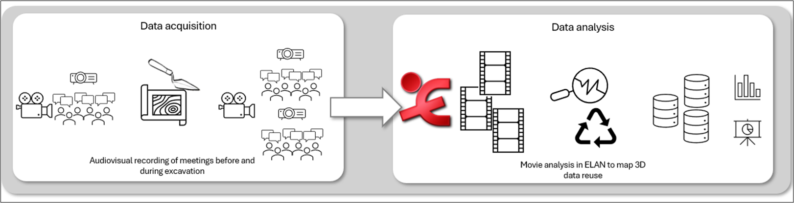
To document and analyse how archaeologists work together using reflexive and multivocal approaches with existing data, we used audio-visual recording, commonly used by ethnographers and linguists to capture and study human interaction in detail (Norris 2004). We recorded both on-site and off-site interactions, capturing individual excavators' perspectives during fieldwork as well as group discussions held around 3D models using the AIR platform (Berggren et al. in prep.). However, for the present paper, we focus on the evening off-site recordings, which brought together all participants and provided consistent and comparable discussions around the same datasets. The recordings were later analysed using multimodal interaction analysis, a discourse analysis approach/method from linguistics, that focuses on how people communicate through talk, gesture, and context (Gumperz 1982; Jaworski and Coupland 2014; Norris 2004). This approach allowed us to identify different types of conversations, contextualise them, and trace how 3D data was used, offering key insights into how archaeologists engaged in data reuse.
In 2004, Karlskrona Municipality started a water treatment project at Johannishus in Ronneby Municipality. As part of the planning phase of this project, Blekinge Museum carried out contract archaeology investigations in accordance with Swedish heritage legislation along the proposed route of the pipeline. A previously unknown and unexpectedly rich Iron Age settlement was discovered nearby the village of Västra Vång, where remains of houses and craft areas were recorded on the village's farmland, indicating a presence on the site from the Roman Iron Age to the Viking Age at least. At the same time, a small bronze mask from the Celtic cultural area was retrieved on a small hill in the centre of the settlement dated to 100BCE-100CE (Helgesson and Svensson 2024).
In the following years, further investigations were carried out, both in the settlement as a whole and on the hill. Because of the well-preserved cultural layers on the hill itself, the choice of archaeological documentation methods has been particularly careful and has been designed from the outset to provide future users with a very detailed set of data.
The complexity of the Västra Vång site and the ongoing debates surrounding it make this case study ideal for developing our experiment. In fact, the absence of a dominant theory about the site's role, despite its evident significance, coupled with the fact that the excavation teams shifted between seasons, provides ample space for different archaeologists to express their theories and ideas. This open interpretive environment is precisely what we were looking for, as it encourages the participation of younger and less experienced archaeologists who might otherwise be cautious or less responsive at sites with more rigid pre-existing hypotheses. By fostering an inclusive and dynamic space for interpretation and idea development, Västra Vång serves as an exemplary setting for our experimental approach.
The Archaeological Interactive Report (AIR) is an advanced information system for documenting, managing, and publishing archaeological excavations, thereby improving data accessibility and dissemination. AIR integrates multiple data types into cohesive digital and interactive reports, which include geographic data, 3D models, images, and video. AIR allows users to interact with 3D data and 2D GIS (geographic information systems) maps, combining text with multimedia elements for richer context and navigation through hyperlinks and cross-references. This makes AIR accessible to researchers, educators, and the general public, aligning with FAIR and Open Science principles (Wilkinson et al. 2016). Its unique features make AIR ideal for experiments analysing the reuse of 3D archaeological data, as it integrates and presents data at a level unparalleled by any other system (Derudas et al. 2023).
Since 2017, the single context method approach and advanced 3D spatial recording techniques have been used to document detailed materials and contexts at the site of Västra Vång. Image-based 3D modelling was used to create 3D models of contexts and artefacts for inclusion in the 3D GIS. Once georeferenced, these models provided the basis for recording contexts and artefact locations using digital polylines and polygons (Dell-Unto 2016). In addition to the GIS, all 3D documentation from the various field campaigns was also published online in the Interactive Visualization System, and finally, from 2021 onwards, integrated and enriched with other data in the Archaeological Interactive Report (AIR). Initially validated with legacy data from the Västra Vång project, AIR has been the primary documentation and interpretation tool since 2021 (Svensson and Derudas 2024).
In the 2023 field season, AIR was actively used on-site at Västra Vång to complete documentation workflows, integrate 3D models, and describe contexts directly through digital record sheets. This setup enabled real-time access to data and its immediate reuse during ongoing survey and interpretation.
This experiment aimed to determine when, and under what circumstances, archaeologists use and reuse 3D digital datasets to generate new knowledge. Specifically, we aimed to observe the interactions among highly experienced archaeologists from diverse backgrounds as they retrieved 3D data from the same online system to support their discussions. We aimed to determine whether the 3D data available through the system was more dominant compared to other forms of digital information. Did the team prioritise the 3D data to support the discussion? If so, how were these data used to communicate and express their narratives?
In order to understand how archaeologists reuse 3D data, it was crucial to define the aims and methods of using audio-video material and to identify what information we could gather. Therefore, before starting the experiment, we outlined a specific workflow to mirror the desired data collection process, as shown in Figure 2. For this study, we focused on the recorded discussions held before and after the excavation activities, when participants collectively reflected on strategies and results. The following sections describe the setup and stages of this workflow in detail.
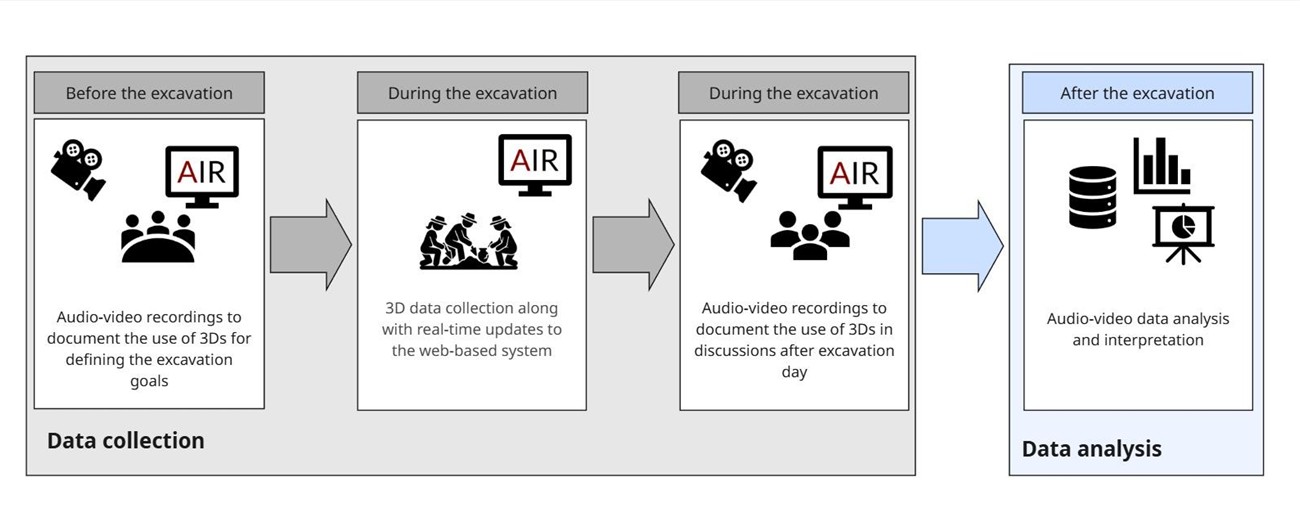
An archaeological excavation season can be planned through discussions amongst the involved archaeologists. In this manner, we structured the experiment around meetings with colleagues to ensure collaborative input. To formulate a research design, archaeologists discuss the research questions and objectives they aim to achieve before the investigation, considering possible constraints of time and budget. Based on these factors and depending on the type of investigation, the excavation team determines a research strategy, inclusive of the study locations, and defines the excavation goals.
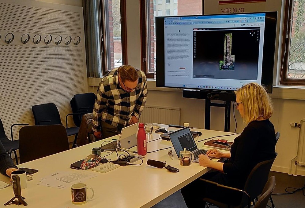
During fieldwork, archaeologists engage in many exchanges and conversations in which they share their opinions on excavation operations and strategies and develop interpretive hypotheses based on previous information and current excavation results (Berggren 2002; Hodder 1999). Meetings and conversations are, therefore, valuable opportunities to gather information on specific components of archaeological practice. The excavation campaign occurred between 1 and 6 May 2023. We decided to record audio and video during the first meeting, which took place two weeks before the start of the excavation, as well as the two meetings that took place in the evenings after the fieldwork. During these evening sessions, the team met to review the field strategy, discuss the preliminary results and, crucially, compare the newly acquired records with those from previous campaigns.
Essential equipment for the experiment consisted of a 360-degree camera and a large screen to project the 3D contents from AIR. We used 360-degree cameras because, unlike traditional cameras, they allowed us to capture all the interactions during the meetings and then optionally separate them to focus on specific components of the conversations. For example, by changing the zoom frame of the video recording, one could focus on the interaction between two people discussing where one of them is using the computer and the other one asks to see something specific on the screen, then they point to it and uses the displayed content to support a conceptual argument. For this reason, in all audio-video recordings, the camera was strategically positioned on a table to frame the large screen and allow the meeting participants to observe all the interactions fully.
These audio and video-recorded meetings were analysed to understand how, and to what extent, the archival records were used in interpreting the new data. Despite spending the entire day in the field, the opportunity to visually aggregate and manage both old and new records during these meetings sparked extensive discussions among team members (refer to Figure 6). The first meeting took place on April 24, with subsequent meetings occurring on May 2 and May 3. In Appendix I, a detailed account of these meetings will be provided, revealing insights into their discussions and outcomes.
Striking a balance between the desired objectives, available time, and resources is crucial in this planning phase. In this context, accessing an archive supported by a system capable of simulating real-time excavation scenarios is immensely valuable for archaeologists. This is why we used AIR as a supportive tool. The system was projected onto a large screen. The archaeologists accessed it on their laptops to engage in the discussion. The 3D data stored in AIR played were essential during the meeting, illustrating archaeological features from past excavation seasons and delineating excavation areas and related datasets. The reuse of 3D models supported interpretations and decisions concerning excavation objectives, trench positioning, and the overall excavation strategy.
Regular meetings amongst archaeologists during an ongoing investigation activity are essential for ensuring a dynamic and collaborative interpretation process. These gatherings offer an invaluable opportunity to share new results, exchange thoughts, address uncertainties, and to collectively refine interpretative hypotheses. As the excavation progresses, new data continuously emerges, and it is through these ongoing discussions that insights are deepened, alternative perspectives are considered, and the overall understanding of the site is advanced (Berggren 2002; Hodder 1999). To support the investigation, we scheduled specific meetings in the evenings at the team's accommodation. In these meetings, the staff formally gathered to review the day's activities, update each other on ongoing hypotheses, and share information with the broader project team. While such discussions typically occur informally on-site, we made deliberate time for structured sessions during the investigation. These meetings focused on the 3D data collected and stored in the system throughout the day, then compared and integrated with 3D data from previous investigations, laying a foundation for more informed and targeted discussions and collaborative decision-making. Although the platform used during the experiment was used regularly and intensely in the field, we chose to consider, for the sake of the experiment, only the evening meetings. This decision allowed us to capture conversations in which all archaeologists were present and engaged at the same time and focused on the same dataset, ensuring consistency in both participation and context during the recorded interactions.
To evaluate 3D data reuse from the collected footage, the following methodology was employed: the discussions from the three meetings were examined to identify and tally the conversations involving 3D models. Simultaneously, the number of models used in each discussion was also recorded. This initial analysis revealed significant differences in how 3D models supported discussion. It became clear that simple frequency counts were insufficient to understand the kinds of reuse the models enabled and how AIR facilitated these interactions.
While quantified metrics provide insight into how often these interactions occurred, they do not explain why, or in what communicative context, they occurred. A more robust analytical framework was therefore required. For this reason, we adopted methods from discourse analysis (see Section 4), which enabled us to examine the multimodal organisation of the conversations, classify speech activities, identify their communicative functions, and connect them to specific uses of 3D models.
This combined quantitative-qualitative approach provides a richer foundation for assessing 3D data reuse and directly supports the evaluation presented in Section 5.
Audiovisual media represent the most effective and comprehensive documentation for capturing human actions and interactions as they occur (Norris 2004, 62). Unlike written notes or still photography, they capture the full range of communication (defined as multimodal interaction in linguistics; see Norris 2004), including body language, gestures, tone, and spatial relationships, all of which are critical for understanding the dynamics of social interaction. These recordings allow researchers to revisit and thoroughly analyse events, offering insights into behaviours and decision-making processes that might otherwise be missed.
Interactional sociolinguistics is a subdiscipline of linguistics that uses discourse analysis to study how language users create meaning via social interaction, for example, drawing on knowledge beyond the conversation to make inferences. Through it, linguists examine the intersections of human language and human society (Gumperz 1982).
In our experiment, it was crucial to observe how archaeologists interact with each other and with the digital tools available. By recording these interactions, we were able to observe and analyse how and why 3D models are used, as well as how information is conveyed and perceived through them. Our goal was to monitor the use and reuse of 3D data during ongoing archaeological excavations, focusing on both the frequency and the purpose of reuse. discourse analysis methods offered the most suitable framework for this investigation.
Discourse analysis (DA) "examines how stretches of language, considered in their full-textual social and psychological context, become meaningful and unified to their users" (Cook 1989, viii), where discourse refers broadly to language as it is used in context and made meaningful through that context. Multimodal interaction analysis, one type of DA, also examines, besides the use of the language of communication, other modes that influence the interactions, such as images and other nonverbal channels, such as gestures, posture, and the distance between images (Norris 2004). One of the modes of interaction we wanted to analyse is 3D models, which can be considered as interactive images. Observing archaeologists' interactions with each other and with the 3D models was essential to determine if and how the reuse of 3D data affects archaeological practice. In addition to examining the interactions between the archaeologists, our objective was to ascertain the extent to which the 3D models shaped the discussions. To achieve this, we had to identify the conversations during the meetings and determine the number of instances where the use of 3D models was involved.
Importantly, Gee defines 'big D' discourses as social practices, mental entities, and material realities (2014, 152) and articulates a concept that aligns perfectly with the characteristics of archaeological meetings, where participants combine and integrate "language, actions, interactions, ways of thinking, believing, valuing, and using various symbols, tools and objects to enact a particular sort of socially recognisable identity" as evidenced by the example of street gang members (Gee 2014, 143). Gee also provides the example of scientists as part of a 'big D' Discourse: their field of study is distributed in their environment "made of the scientific apparatus, symbolic systems, books, papers, and journals, institutions, habits of bodies, routines of practice, and other people" (Gee 2014, 148). Moreover, Gee argues that "each domain of practice, each scientific Discourse - for a specific area within physics or biology - attunes actions, expressions, objects and people (the scientists themselves) so that they become 'workable' in relation to each other and in relation to tools, technologies, symbols, texts, and the objects they study in the world. They are 'in sync'" (Gee 2014, 148).
In verbal interactions (or Discourses, including archaeological meetings), context-related social norms define the participants' roles, topics, and ways of speaking (Gumperz 1982, 165). To analyse them we identified conversational units, or 'speech activities' (SA), according to Levinson's definition described by Gumperz as follows:
a speech activity is a set of social relationships enacted about a set of schemata in relation to some communicative goal. SA can be characterized through descriptive phrases such as 'discussing politics', 'telling a story to someone' …. Such descriptions imply certain expectations about thematic progression, turn taking rules, form and outcome of the interaction, as well as constraints on content” (Gumperz 1982, 165–66)
In our Discourses, where several speech activities were identified, it was even more important to determine the nature of these activities. To use a sociolinguistic definition, we had to identify the speech activities' genres:
Genres are kinds of communicative acts that involve particular kinds of interaction and setup particular kinds of relationships between interactants. Each genre fulfils specific communicative functions such as persuasion, entertainment, teaching, bonding, etc” (Machin and van Leeuwen 2014, 172)
We aimed to define the genre for each speech activity identified in our 'big D' discourses (meetings) to:
Identifying the speech activities, determining their genre, and determining how much the 3D models (a kind of media in such a multimodal interaction) have been used to convey communication could allow us to quantify the reuse of archaeological data (with our main focus on 3D models).
This approach holds great potential for studying how different aspects of the excavation process, such as data, interactions, and key moments, can be observed and quantified. It would offer a clearer picture of which data are most impactful or frequently used (or reused) and their role in shaping the various stages of field interpretation.
In addition to informing us about how archaeologists use and reuse their data in a given setting (Gee 2014), this is also essential for identifying patterns in archaeologists' behaviour. By expanding the use of socio-linguistic approaches, other components that influence archaeologists' interactions, such as hierarchies or gender balance, could be analysed in the future.
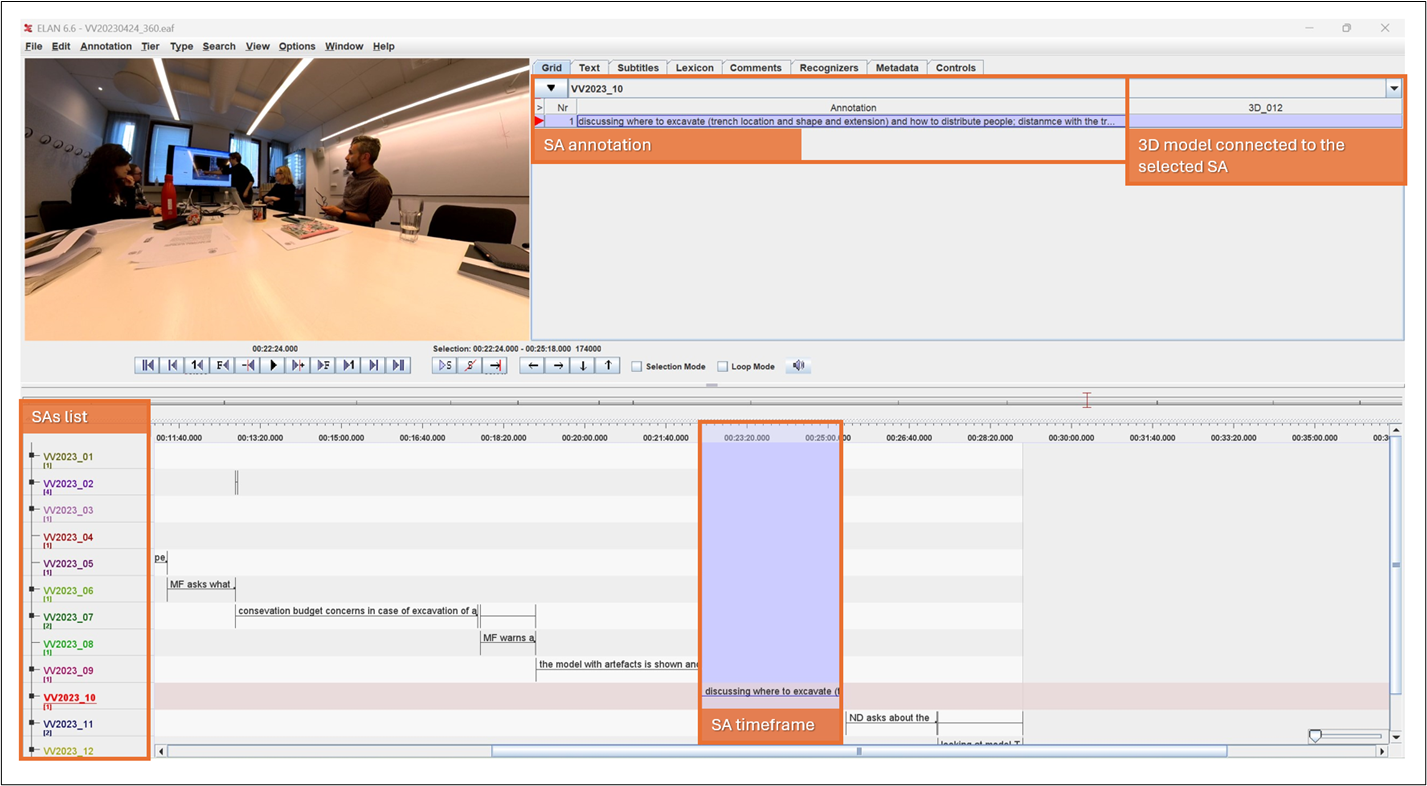
Once acquired, the videos were annotated in ELAN (Sloetjes and Seibert 2016), a free tool for multi-layered, time-aligned annotations widely used in the language sciences, developed by The Language Archive at the Max Planck Institute for Psycholinguistics in Nijmegen, the Netherlands (Sloetjes and Seibert 2016). It allows for annotating and cross-referencing anything observed, be it speech, gestures, actions, and physical features through labelled layers, which in turn enables us to link video sections with speech activities and genres. Thus, ELAN provides us with the ideal environment for analysing the complex interactions and discourses that took place during the meetings, allowing for precise and structured documentation of both verbal and non-verbal elements (see Figure 3).
In ELAN, we identified the speech activities (SA), assigned them genre labels and enriched them with textual annotations summarising the conversations. Within the software, the annotation layers (a.k.a. "tiers") can either be completely independent, sharing only a common timeline, or hierarchically structured. The latter allows for linking annotations across tiers. For example, a "parent tier" may contain information that is further contextualised in a separate "child tier". A parent tier might mark a segment of speech as a specific type of conversation (e.g. a discussion of trench strategy), while the child tier could indicate which 3D model was being referenced during that segment. In this scenario, the child annotations directly reference the parent annotations. The 3D models used in the conversations were hierarchically connected to the speech activities tiers as 'child tiers'.
We aimed to observe and quantify how 3D models and digital documentation were used in archaeologists' 'big D' discourses during fieldwork activities. To enable this, we organised the data prior to analysis according to the following pipeline:
Focusing on each genre played a crucial role in our experiment's overall effectiveness and success, as it allowed us to track how and to what extent the 3D models influence each critical phase of the archaeological investigation.
After reviewing all the conversations from the meetings, we identified five communicative functions related to how the 3D models supported these discussions, and we categorised their corresponding genres as follows:
The following section provides a detailed account of the study results and explores their broader significance in the context of archaeological practice.
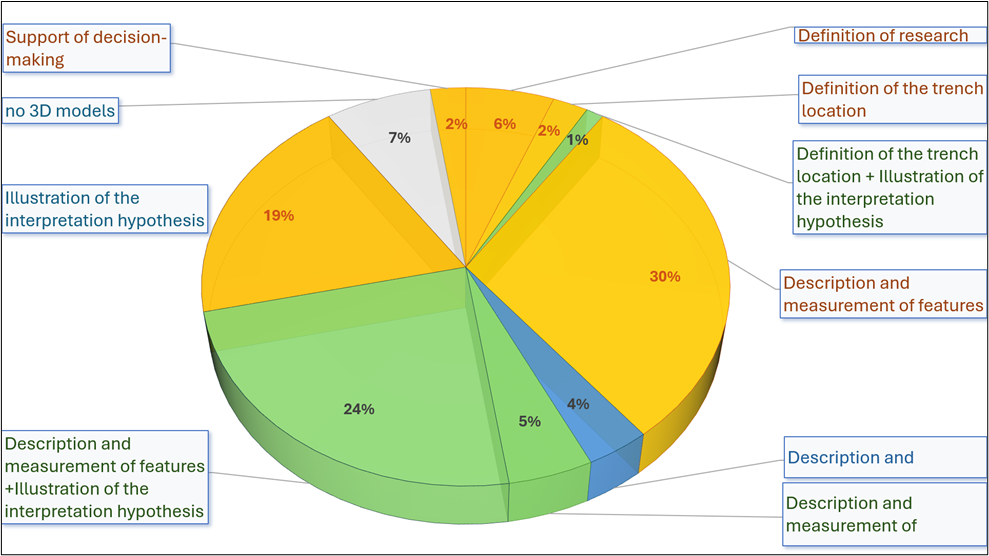
Several distinct patterns emerged in how 3D models supported different types of conversations. As discussed in the previous section, to organise the study results, we categorised the conversations into speech activity (SA) and further identified the genres associated with each conversation. The use of 3D models in multi-genre conversations was also a notable finding. Table 1 illustrates all genres identified in the speech activities:
| Genres identified in the SA |
|---|
| Definition of the trench location |
| Description and measurement of features |
| Definition of research questions and goals |
| Illustration of the interpretation hypothesis |
| Support of decision-making |
| Description and measurement of features + illustration of the interpretation hypothesis |
| Description and measurement of features + support of decision-making |
| Definition of the trench location + illustration of the interpretation hypothesis |
| Description and measurement of features + illustration of the interpretation hypothesis + support of decision-making |
| No 3D models |
In the pre-excavation meeting, we identified and annotated 33 instances of SA in which archaeologists used 60 3D models. We assigned one genre to 16 SA and observed that 3D models were used 29 times. We also found 13 instances where multiple genres were involved in a single conversation. 3D models were used 31 times in these two-genre SA to support different combinations (see Table 2 for details).
| Genres in SAs | SA count | Genres per SA | 3Ds count |
|---|---|---|---|
| Definition of the trench location | 2 | 1 | 4 |
| Description and measurement of features | 6 | 1 | 10 |
| Definition of research questions and goals | 5 | 1 | 9 |
| Illustration of the interpretation hypothesis | 3 | 1 | 6 |
| Description and measurement of features + illustration of the interpretation hypothesis | 8 | 2 | 20 |
| Description and measurement of features + support of decision-making | 4 | 2 | 10 |
| Definition of the trench location + illustration of the interpretation hypothesis | 1 | 2 | 1 |
| No 3D models | 3 | ||
| Total | 33 | 60 |
The first post-excavation meeting occurred on 2 May, after the second day of excavation. During this meeting, 25 conversations were recorded, and 3D models were used 51 times.
15 one-genre SA were identified, where 3D models were used 36 times to support different tasks. Eight two-genre SA were counted, where 9 3D models were used. There were two instances of three-genre SA, where nine 3D models were employed simultaneously (see Table. 3).
| Genres in SAs | SA count | Genres per SA | 3Ds count |
|---|---|---|---|
| Description and measurement of features | 9 | 1 | 26 |
| Illustration of the intepretation hypothesis | 5 | 1 | 9 |
| Support of decision-making | 1 | 1 | 1 |
| Description and measurement of features + illustration of the interpretation hypothesis | 8 | 2 | 6 |
| Description and measurement of features + illustration of the interpretation hypothesis + support of decision-making | 2 | 3 | 9 |
| Total | 25 | 51 |
The final recorded meeting involved 27 conversations, in which 3D models supported the dialogue 42 times. 19 one-genre SA were identified, in which archaeologists used 3D models 25 times. Four two-genre SA were observed, in which 3D models were used 15 times. There were also two instances of three-genre SA, in which 2 3D models were employed (see Table 4).
| Genres in SAs | SA count | Genres per SA | 3Ds count |
|---|---|---|---|
| Description and measurement of features | 10 | 1 | 12 |
| Illustration of the intepretation hypothesis | 8 | 1 | 12 |
| Support of decision-making | 1 | 1 | 1 |
| Description and measurement of features + illustration of the interpretation hypothesis | 4 | 2 | 15 |
| Description and measurement of features + illustration of the interpretation hypothesis + support of decision-making | 1 | 3 | 2 |
| No 3D models | 3 | ||
| Total | 27 | 42 |
Over the course of the three meetings, we documented 85 conversations in which archaeologist's 3D models were used 153 times. We were able to assign specific genres to 78 conversations, with the following key results: 50 one-genre SA were observed, where 89 uses of 3D models were recorded. The most frequent use was for describing and measuring features (25 SA using 48 models), followed by illustrating interpretation hypotheses.
29 two-genre SAs involved the use of 41 3D models. The most common combination was describing and measuring features along with illustrating interpretations, occurring in 20 instances. Three three-genre SAs involved 12 3D models used simultaneously for describing and measuring features, illustrating hypotheses, and making decisions.
These results clearly demonstrate the central role of 3D models in archaeological practice, illustrating their versatile use in various stages of fieldwork, from interpretation and measurement to decision-making. The results also highlight the ability of 3D models to support both single-focused and multi-layered discussions, emphasising their potential for reuse across diverse contexts (see chart in Figure 5 for details).
The analysis of the meeting conversation was highly informative. During the first meeting ("Before"), archaeologists mainly reused 3D models from previous excavations for descriptive purposes, to revisit or better understand the stratigraphy already uncovered. Measurements on the 3D models and the integration of multiple models within the same virtual environment allowed archaeologists to illustrate initial hypotheses and to decide, based on the research questions, the placement of the trench. During the post-excavation meetings ("During"), archaeologists naturally engaged in various discussions while using the web archive, mainly navigating through 3D models from previous and current investigation seasons. They described the day's excavation activities, shared their ideas, and compared features encountered and documented in previous seasons. Numerous interpretive hypotheses were formulated, challenged, and refined, significantly increasing engagement and participation among the entire team.
Overall, our analysis reveals the multifaceted utility of 3D models in archaeological discussions, both as tools for visualisation and measurement and as supports for interpretation and decision-making. The widespread and varied use of 3D models in these conversations underscores their value in enhancing communication, refining interpretations, and improving the efficiency of archaeological processes. The results reinforce the importance of continuing to explore the reuse of 3D models in archaeological work, particularly as a means of facilitating knowledge exchange and field-based decision-making.
The analysis reveals how 3D models facilitate various forms of archaeological dialogue. The breakdown of speech activities (SA) shows that 3D models support not only the description and measurement of features but also the illustration of interpretative hypotheses and decision-making. Several conversations are characterised by multiple genres and this highlights how 3D models are used across different contexts and stages of excavation work.
The visual and interactive aspects of 3D models and the combination of multiple instances at the same time allowed archaeologists to move beyond traditional discussions. For example, the archaeologists could interpret the posthole in trench B using the current 3D stratigraphy and compare it with the 3D stratigraphy from the 2017 season, the interpretation of which was still to be confirmed.
Categorising different types of speech activities and engaging in multi-genre conversations indicates the versatile use of 3D models, suggesting that the infrastructure allows for flexibility and reusability.
The results allowed us to observe how using a 3D platform facilitated both information exchange and decision-making from a visual and interaction perspective. It is highly significant how 3D data reuse enhances the confidence of the interpretation process. Having instant access to 3D data from all trenches and excavation seasons and the related information made archaeologists very confident in building and testing their interpretations.
However, certain aspects that characterised the experiment and could be viewed as limitations in assessing the results need to be taken into consideration. In fact, one archaeologist handled the system throughout the 3D data reuse experiment. While this approach was suitable for the current setting (where participants collaborated to interpret data and plan excavation activities), it also revealed a key limitation. Although AIR allowed for dynamic recombination of scenes, enabling the integration of multiple 3D models and contexts, this functionality was mediated by a single technically skilled user. Other archaeologists participated by requesting specific models or configurations, which the operator then managed. This setup supported group discussion but restricted individual exploration and experimentation.
This paper aims to advance research on 3D data reuse by analysing how archaeologists reuse 3D models from archaeological datasets. We sought to investigate the role of reuse in the interpretation process and to deepen our understanding of how archaeologists engage with 3D data in current archaeological practice.
Based on an ad-hoc experiment at the Västra Vång site in southern Sweden, the study used a discourse analysis approach from the sociolinguistic discipline to assess how the reuse of 3D models supports archaeological reasoning, interpretation, and decision-making.
The results of this study highlight the significant role that 3D data can play in shaping archaeological practice and knowledge production in the field. They also demonstrate how 3D models facilitate complex multi-genre conversations, providing archaeologists with tools to visualise, measure, and interpret data to enhance collaboration and confidence in their conclusions. This not only saves time that would have otherwise been spent on traditional forms of documentation and reporting but also fundamentally changes the relationship between archaeologists and data in the field. Providing tools to interact with excavation results in real-time can be a transformative intervention in archaeological fieldwork by democratising the planning and in situ interpretation of field excavations.
However, we also identified limitations that need to be addressed in future research. In particular, the fact that only one archaeologist manages the 3D data provided a limited perspective on how the platform supports the wider user experience. For this reason, we plan to design future experiments in which all participants interact with the 3D platform independently. Analysing the user experience will help us to better understand the challenges and barriers that users face when reusing 3D data. In addition, by gathering user feedback, we aim to identify areas for improvement in the system design. This will allow us to create more intuitive and flexible tools that enhance the reuse of archaeological data in both collaborative and individual settings.
Finally, we have identified a need to think critically about how the reuse of 3D data can affect the curation of archaeological information in both positive and negative ways. As more and more archaeological reporting moves into the digital realm, it becomes increasingly important to explore how this transition shapes archaeological practice. This applies both to future forms of data reuse and to the reuse of older archaeological reports, those written under different circumstances, when the report was seen as the final product and both digital and non-digital field data were treated mainly as working material, not intended for long-term reuse.
This study was vital for understanding which types of 3D models and visualisation methods most effectively support interpretation, aiming to enhance future research practices and data reuse. By creating data and tools with reuse in mind, future archaeologists can revisit and better understand past interpretations and the reasoning behind them. This approach ensures that interpretations are not only documented but also accessible and meaningful for future reuse and research, promoting a more robust and reflective practice.
In future research, this approach could be used to examine both the linguistic and non-linguistic elements of these interactions, providing a more comprehensive understanding of how knowledge is constructed and negotiated in group settings. Through this lens, we expect to identify communication patterns that enhance the reuse of 3D models and support decision-making and interpretation processes.
In conclusion, this study examined the practice of 3D data reuse among archaeologists to identify the factors that facilitate or hinder reuse. The methods employed, adapted from linguistics, are innovative within archaeology and made it possible to both quantify and qualify 3D data reuse. The results, although preliminary, emphasise the disciplinary importance of developing flexible platforms that integrate multimedia datasets, as they are vital for effectively supporting data reuse and ensuring the continued reuse of 3D data in archaeology. Our findings contribute to the broader debate on the reuse of archaeological research data, underscoring the need for further investigation.
All authors participated in the experiment and contributed to the fieldwork at Västra Vång, as well as to the collective archaeological discussions.
Paola Derudas coordinated the study, led the video sessions, and participated in the excavation. She analysed the audiovisual material, carried out the ELAN annotation, compiled and interpreted the results, and drafted the main manuscript, including all the Sections.
Nicolò Dell'Unto co-designed the experiment with Paola Derudas, participated in the field campaign and recorded discussions, and contributed primarily to Sections 1, 3, and 6.
Danilo Marco Campanaro contributed to structuring the paper, participated in the fieldwork and recorded discussions, and contributed to Sections 1, 3 and 6.
Åsa Berggren contributed to the design of the experiment, to the theoretical and methodological framing of the study, and to the state-of-the-art discussion. She contributed to Sections 1, 2, and 6.
Jens Larsson set up the ELAN environment, supported the organisation and integration of information within it, he acquired and processed the audiovisual recordings, and contributed to Section 4.
Andreas Svensson contributed to field data acquisition and contributed to Sections 3, 4 and 6.
Mikael Fauvelle participated in the fieldwork, contributed to the archaeological and interpretive discussions, and supported the writing and revision of the paper. He contributed to Section 4, 6.
Domenica Dininno participated in the fieldwork, contributed to the archaeological and interpretive discussions, and supported the writing and revision of the paper. She contributed to Section 6.
This paper is part of the Transforming Data Reuse in Archaeology (TETRARCHs) project, a European project that aims to enrich archaeological data for broader and more meaningful reuse. One of the research strands of TETRARCHs focuses on the reuse of 3D data by practitioners to understand how reuse occurs and how it can be encouraged. The experiments presented in this paper attempt to observe and analyse data reuse practices, which can guide the improvement of archaeologists' tools based on reuse experiences.
The paper is also supported by the Digital Integration Across Disciplines, a collaboration between the Department of Archaeology and Ancient History, the Linguistics division at the Centre for Languages and Literature, and the Humanities Laboratory at Lund University (DIAD). DIAD has undertaken a synthesis of Digital Archaeology and Language Documentation, creating digital records of cultural heritage through conceptual, theoretical and methodological exchange and mutual enrichment.
This research was conducted with the support of the Lund University Digital Archaeology Laboratory (DARKLab) and the Swedish National Infrastructure for Digital Archaeology (Swedigarch).
The authors gratefully acknowledge Dr Nicole Kruspe (Centre for Languages and Literature, Lund University) for facilitating the recordings of the meetings. The authors sincerely thank Dr Trevor Grimshaw for his insights into multimodal discourse analysis, as well as for the valuable discussions on its application to archaeological discourse.
The structure and language of this chapter were reviewed and refined using AI-assisted tools, including OpenAI's ChatGPT-4o and DeepL Write.
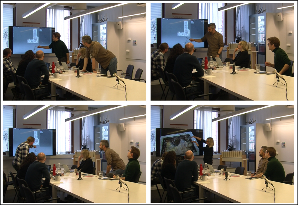
Six archaeologists gathered on April 24th to discuss and define the excavation research questions and objectives based on the time and budget constraints. They met in a meeting room at Lund University with a big rectangular table, a large screen on the short side, and a 360-degree camera positioned on the other side of the table (see Figure 6). Colleagues from the Department of Linguistics curated the audio-video recordings.
The participants sat on the side close to the screen to easily visualise the projected data. The meeting did not have a specific agenda but had a broader scope to introduce the excavation to new participants and to define the objectives of the forthcoming excavation. The archaeologists discussed the site and the investigations carried out to date, and defined the objectives and logistics of the excavation. Two of the archaeologists had not been involved in previous investigations at the site. For this reason, their colleagues described the previous investigations and gave initial interpretations of the archaeological features already documented.
One participant operated the system and displayed the 3D features needed to support descriptions and arguments. By interacting with the 3D models displayed on the screen, the archaeologists could show and talk about the extent and topography of the site, the location of the trenches, and focus on specific archaeological features that needed further investigation to interpret. Each participant randomly intervened in the conversations to add details, memories, thoughts and interpretations, always using the 3D environment to engage in the conversations. The archaeologists who were new to the site asked several questions, using the 3D models as a reference to ask for clarification (see Figure 7).
The discussions were also preparatory to the positioning of the investigation areas in relation to the excavation objectives: to determine the existence of a post-built structure and its orientation by finding at least one more posthole to confirm previous hypotheses.
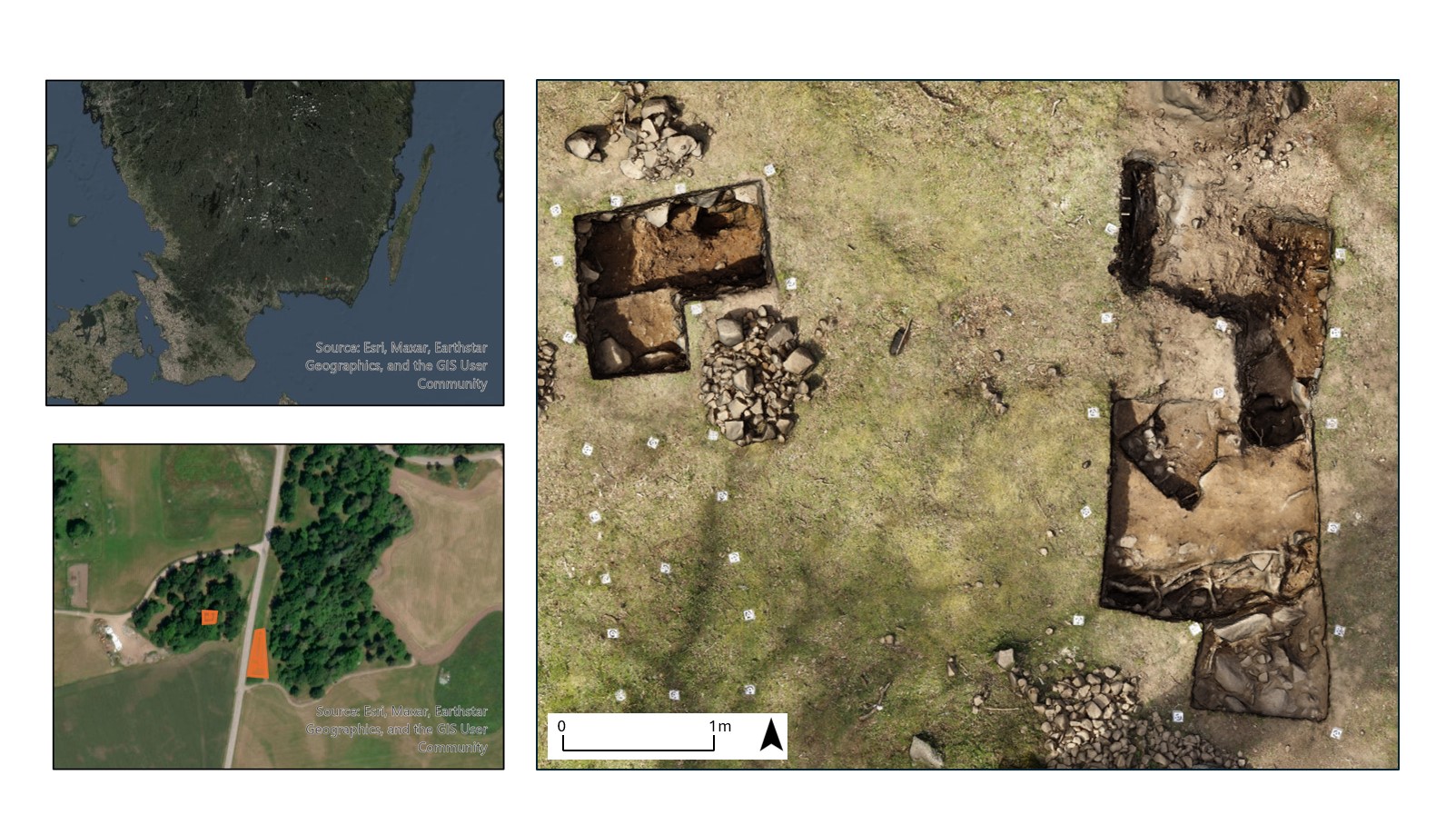
In the second part of the meeting, the participants discussed the upcoming fieldwork, the different possibilities for positioning the investigation areas, and the logistics of the campaign. This was accomplished by utilising all the tools available through AIR, such as measuring distances between trenches excavated and features removed during different investigations, reviewing the spatial distribution of artefacts, and examining the finds in relation to the area's morphology. One outcome of the pre-excavation meeting was the formulation of an excavation strategy for the 2023 investigation campaign. Two trenches were planned (A and B, see Figure 1). Both were aimed at further understanding the structure and layout of a hypothesised post-built structure.
Trench A was planned as approximately 3x2 m stretching southwards from the eastern of the two postholes previously excavated. The aim of this trench was to locate additional postholes and/or structural features to corroborate the hypotheses of an east-western orientation of the building. It was estimated that the trench could not be opened far enough southward to incorporate any wall features. Instead, a slightly larger breadth of two meters was chosen, giving the possibility of uncovering more of the internal floor surface. This would serve as a stratigraphic link between the structural features.
Trench B was centred on the western posthole excavated in 2017. During the initial campaign, hesitations were raised regarding whether the feature should be interpreted as a posthole and, if so, if it was connected to the hypothesised structure. To counter these uncertainties, an area of approximately 2x2 meters was chosen as a starting point for the trench, expanding the trench excavated in 2017, which had not uncovered the feature in its entirety. Trench B aimed to strengthen the interpretation of the feature and relate it as firmly as possible to the overall site stratigraphy. For both trenches, expansion possibilities were planned already at the pre-excavation stage if time proved sufficient for larger trenches.
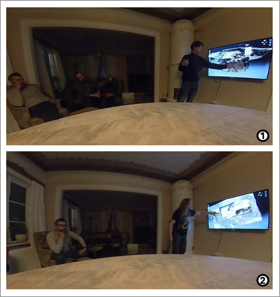
The meeting took place after dinner in the hotel's dining room, with seven archaeologists participating. Audio-video recordings were curated by colleagues from the Department of Linguistics, while one archaeologist operated the system, which was projected on a screen mounted on the wall via Bluetooth connection. Some of the participants were seated around a table, with others sitting in chairs scattered throughout the room (see Figure 8).
As with the previous meeting, there was no fixed agenda, and the archaeologists began by presenting the work done in the two opened trenches, A and B. During the meeting, one archaeologist described the characteristics of the layers excavated in trench B using the 3D model produced earlier that day and uploaded into AIR. Colleagues asked questions, searching for similarities with layers documented in previous excavations. They recalled interpretations from the 2017 trench, examining the section and using 3D models from 2019 to identify comparable situations.
The archaeologists new to the investigation asked questions about the 2019 excavation, particularly noting several visible features in the 3D model. Initially, these were interpreted as root disturbances, but as the excavation progressed and new information emerged, the interpretation shifted—they could also be depositional pits with root disturbances.
The same 3D model was then used to describe the excavation operations in trench A, with the archaeologists searching for analogies with features identified in earlier 3D models. To gain an understanding of the distance between postholes, measurements were taken directly from the 3D models, including the depth of a fully excavated one. By analysing 3D models from 2017, 2019, 2021, and 2023, the team developed hypotheses regarding the posthole's depth and the potential for it to have been reset multiple times, depending on the type of building—whether a longhouse or a four-post cult house. All 3D models from these different excavation seasons were visualised together within the same digital canvas, enabling the team to virtually inspect features that could no longer be seen in the field, as the trenches had been backfilled after each season. In particular, they reviewed the complete 3D stratigraphy of trench B, excavated in 2017, to retrace earlier interpretations and compare them with the posthole in trench A, which had been fully excavated in 2021. This integrated visualisation allowed the archaeologists to plan the next day's work in both trenches, enriching their conversation with insights from the current excavation as well as preserved evidence from past campaigns.
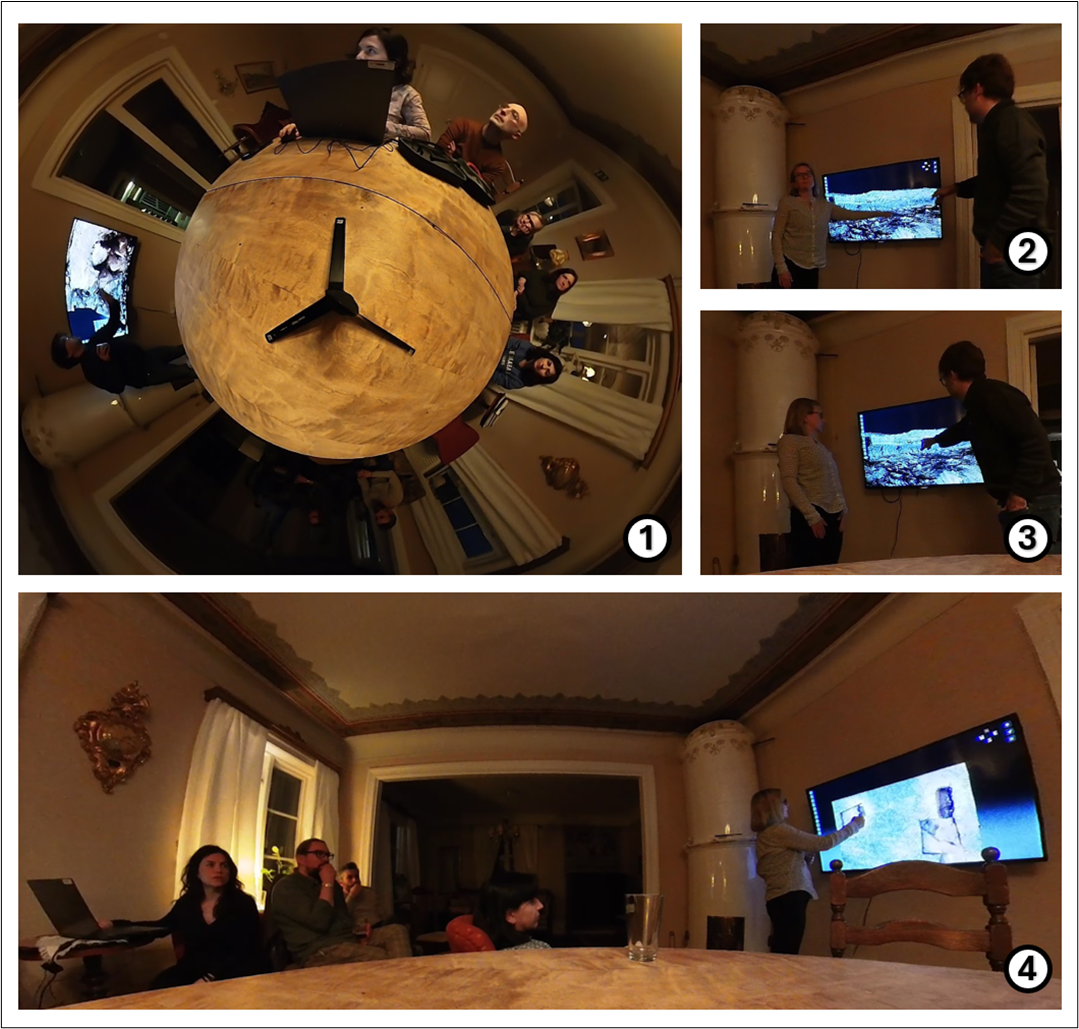
To conclude, it was clear that 3D models had a huge impact on the discussion, enriching the archaeologists' understanding of the ongoing investigation. The ability to assemble various hypotheses on the same 3D canvas facilitated comprehensive, enriching visualisation.
On May 3rd, seven archaeologists gathered in the hotel's dining room to discuss the results of that day's excavation and plan the activities for the following day. Once again, colleagues from the Department of Linguistics handled audio-video recordings.
Again, some participants sat around a table, with others in seats scattered throughout the room. One archaeologist operated the web platform, projected on a TV mounted on the wall. As with the previous meeting, there was no formal agenda, and the participants began by discussing the day's excavation activities in trenches A and B (see Figure 9).
Archaeologists working in trench B illustrated the stratigraphy retrieved during the day using the visualisation tools available through AIR. This time, multiple 3D models were combined and sliced through the section using the Plane Sections tool to describe the layers' characteristics from a frontal perspective. This method not only revealed the stratigraphic relationships between contexts but also showed the amount of soil removed. The conversation centred on whether a posthole had been identified: as the archaeologists navigated the 3D model, they hypothesised the possible resetting of the posthole over time, suggested by different fills observed in the stratigraphic sequence.
During the discussion, the combined 3D models of both trenches were examined, focusing on the potential presence of postholes. Distances were measured, although the corresponding posthole had yet to be confirmed. Possible locations for additional postholes were also considered. An overview of the excavation in trench A was provided, using the 3D models produced during the day to demonstrate the progress, highlight contexts that could suggest floor layers, and indicate a stone alignment that needed further excavation before any conclusions could be made. For both trenches, the 3D models were used to outline the excavation strategy for the following day.
In conclusion, the use of 3D models appeared crucial to describing and illustrating the archaeological features and proposing initial interpretations. Using and combining multiple 3D models allowed all participants, including those not involved in the digging activities, to understand the excavation features clearly.
Internet Archaeology is an open access journal based in the Department of Archaeology, University of York. Except where otherwise noted, content from this work may be used under the terms of the Creative Commons Attribution 3.0 (CC BY) Unported licence, which permits unrestricted use, distribution, and reproduction in any medium, provided that attribution to the author(s), the title of the work, the Internet Archaeology journal and the relevant URL/DOI are given.
Terms and Conditions | Legal Statements | Privacy Policy | Cookies Policy | Citing Internet Archaeology
Internet Archaeology content is preserved for the long term with the Archaeology Data Service (ROR). Help sustain and support open access publication by donating to our Open Access Archaeology Fund.
 Home
Home