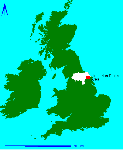
Fig.1 Heslerton Parish Project Area: Location
The archaeological landscape is a fragile, disappearing and frequently little understood resource; conventional methods of field research tend to be both time-consuming and labour-intensive and produce a patchy and inconsistent record which reflects varying site visibility rather than poor research. Nevertheless the Sites and Monuments Records (SMRs) of England at least, which have grown in response to random discovery rather than intensive landscape research, tend not to contain sufficient contiguous detail to allow reliable assessment of landscapes from the record. If we are to preserve, or at least mitigate against damage to, this resource successfully, or even to undertake realistic assessment of landscapes as part of nationally established research agendas we need to re-assess our methods of site identification and discovery radically, lest the conservation movement lead to an entirely non-research based process of preservation or examination based on random discovery rather than academic selectivity. Therefore, it is important to have an objective assessment and analysis of new and established non-invasive prospecting techniques, comparing and contrasting the returns from each. In a perhaps vain attempt to protect this valuable, hitherto unknown, archaeological resource from the predation of unlawful metal detecting, we have deliberately left off all the scales, grids and north arrows from the plans.
Fig.1 Heslerton Parish Project Area: Location
Following the discovery in 1977 of an Early Anglo-Saxon
inhumation cemetery at a sand quarry on the southern margin of
the Vale of Pickering at West Heslerton, North Yorkshire, a rescue
excavation programme was established to recover further archaeological
evidence from the site before it was irretrievably lost through
mineral extraction. By the end of 1980, following small-scale
summer rescue excavations and air photographic sorties undertaken
with the assistance of a local farmer, it was realised that the
site formed part of a rich archaeological landscape in an area
previously thought to have been of limited interest only. Antiquarian
and early archaeological work in the region had been focused almost
exclusively on the upstanding monuments on the chalk of the Yorkshire
Wolds to the south. The work of Greenwell and Mortimer in particular
generated data that gave support to an emerging picture biased
towards later prehistoric funereal monuments and to the overriding
importance of the Wolds, rather than the adjacent low-lying regions
such as the Vales of Pickering and York (Greenwell & Rolleston
1877; Mortimer 1905).
The Heslerton Parish Project was established in 1980 to provide a research framework for the rescue excavations then in progress at Cook's Quarry, West Heslerton (Powlesland 1981; Powlesland et al. 1986). The project research design argued that to undertake a large rescue excavation in isolation from the surrounding landscape would considerably reduce the benefits accruing from the rescue excavations. By assessing the broader landscape, the context of the area being excavated could be fully evaluated, something that was particularly necessary since the excavation site itself was selected not as a consequence of detailed academic research, but in response to the threat of destruction by mineral extraction. The project was among the first 'landscape archaeology' projects proposed in Britain. As time has progressed, the initial rescue excavation and landscape research has been followed up by two further major excavations, the West Heslerton Anglian Cemetery Excavation and the West Heslerton Anglian Settlement Project, both funded by English Heritage as part of the national rescue archaeology programme (Powlesland et al. 1996, Powlesland and Haughton forthcoming; Powlesland et al. 1986). At the same time, small-scale sample excavations, designed to provide evidence of the date range and function of a number of sites identified from the air, were undertaken, funded by North Yorkshire County Council and the American research foundation, Earthwatch.
The project research area covers a 10km square, centered upon West Heslerton, and spans a number of distinctive geomorphological zones which extend both to the east and west of the area and form a representative sample of the landscape at the interface of the Yorkshire Wolds and the Vale of Pickering (Powlesland et al. 1986). It was argued at the outset that by drawing together the information gathered from a 10km wide transect cutting across the grain of the landscape, at a right-angle to the slope of the Wolds, the archaeological landscape could be evaluated in a way that could be applied and tested on a much broader front than that defined by the limits of the project area. The continuation of the geomorphological zones identified within the project area both to the west and to the east for a further 10km provides a highly testable environment in which to evaluate landscape interpretations established within the primary research zone. Air photographic sorties and chance discoveries made in both these areas demonstrate that the essential model is correct and that we may ultimately be able to define an extensive series of landscape use zones. Given the limited resources available it was argued that an intensive study of the project zone would be far more effective than a disparate approach to documentation of the broader landscape.
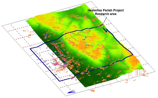
Fig.2 Cropmarks draped over a Digital Elevation Model
In parallel with rescue excavations, a ten-year program of intensive oblique aerial photography (1978-1988) was undertaken with the assistance of a local farmer and pilot, Carl Wilkinson. By 1988 this survey had generated new evidence which radically changed our understanding of the landscape, particularly in the low-lying plain of the Vale of Pickering. Since then, flights have been fewer and have generated more limited crop and soil mark returns. The decline in the return from the oblique air-photography was viewed not as a reflection upon the lack of archaeological features in the landscape, but a limitation imposed by land-use and agricultural activity. In 1984, it became quite clear that sites which had previously remained invisible to aerial photography could produce dramatic crop-mark evidence following a change in the ploughing regime. An increase in reported plough depth of 'one or two inches' in one case, provided an environment in which detailed and extensive crop-marks could be recorded where none had been noted before. It is still unclear whether this dramatic change in response resulted from the truncation of features and the adjacent deposits increasing the contrast between intrusions and the background soils, or whether this arose following the destruction of mineral pans at the base of the plough soil which restrict the development of archaeological crop marks. What was becoming increasingly clear was that a number of sites showed clearly in almost every year, and, more worryingly, the evidence seemed to indicate that those sites that were most clearly visible may in fact have been those least preserved, in which ploughing had removed any occupational surfaces leaving the strongest difference between the natural soil and the cut archaeological features. This observation requires careful testing since preservation through scheduling has tended to be focused upon those sites which produce clear crop-marks rather than adjacent areas which may remain better preserved but produce a low crop-mark return. By 1990 it was felt that the returns from additional oblique air-photography had reached saturation level, such that only changes in agricultural methods on a field-by-field basis were likely to generate a significant increase in returns. The present project has been made possible by the award of an Natural Environment Research Council (NERC) Data Award, a grant from English Heritage to cover data processing and interpretation and the support and assistance provided by the University of Durham and the North Yorkshire County Sites and Monuments Record (SMR).
©
Internet Archaeology
Last updated: Wed Apr 23 1997