Cite this as: Gaffney, V. et al. 2020 A Massive, Late Neolithic Pit Structure associated with Durrington Walls Henge, Internet Archaeology 55. https://doi.org/10.11141/ia.55.4
Possible astronomical alignments associated with the monuments in the study area have been investigated using specially written software. This combines the known movements of the sun and moon with horizon data derived from a digital elevation model (DEM). The software accounts for relevant features such as the variation of solar movement over archaeological time scales and the effect of refraction. The DEM used reflects the modern landscape. It was beyond the scope of this project to attempt to reconstruct the Neolithic landscape or archaeological features such as the banks at Durrington Walls. However, one important adjustment made was the removal of the modern road passing through Durrington. This was essential for a proper treatment of the views from the Southern Circle and Avenue.
The software was tested by investigating the alignments at Durrington described by Ruggles (2015). Figure 9.1 shows the view towards the winter solstice sunrise from the centre of the Southern Circle. As expected, the sun is seen to rise between the large entrance posts to the circle.

This figure has features in common with others in this report that require some explanation. The yellow arc represents the path of the sun; the green and red arcs represent the minor and major lunar limits. There is little cost in calculating the lunar limits, but they form no part of the current analysis. In all cases the observations have been calculated for the year 2400 BC. The distance to the horizon is represented by the colour of the ground: the darker the green the further the horizon. In this case the horizon towards the sunrise is about 4km distant but to the right of the figure this reduces to about 200m.
Figure 9.2 shows the view in the other direction: from the Avenue, through Durrington Walls to the summer solstice sunset. The markers ‘a’ and ‘b’ represent the putative gap in the henge boundary to the north-west. The ground has been rendered transparent to show that the sun goes below the local horizon, 600m distant, about half an hour before it reaches 0° elevation. The viewshed in Figure 9.3 shows that this horizon is just beyond the bank.
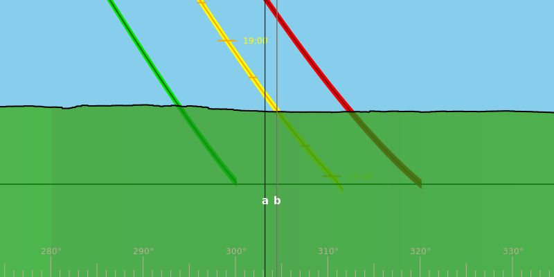
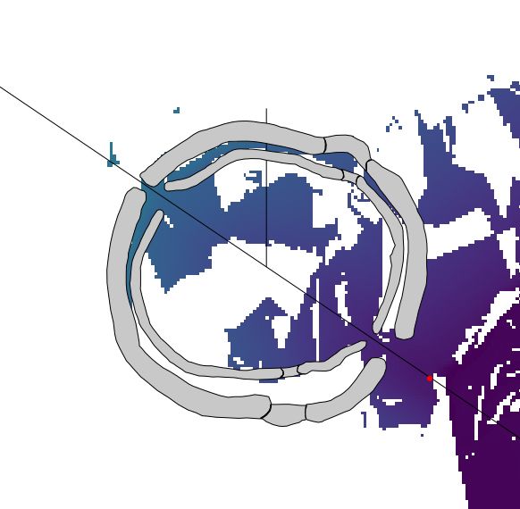
Table 9.1 summarises the distance to the horizon in the four solstitial directions for the pits of the southern arc. Short horizon distances are likely to be particularly sensitive to slight changes in location or uncertainties in the DEM. The table therefore highlights (in yellow) distances greater than 500m. This makes it easier to see trends in the data. For example, it is apparent that all pits in this arc have similar views towards the winter solstice sunrise in the direction of Boscombe Down. There is no particular focus: each pit is looking towards a different point on the horizon. For the summer solstice sunrise half of the pits have horizon distances of about 9km. These represent views towards Dunch Hill (5A, 6A, 7A) or Clarendon Hill (1A, i). Figure 9.4 shows the last of these. The views towards the summer solstice sunset all have rather short horizon distances. The corresponding winter sunset shows more variability between pits. Of particular note are pit i, where the sun sets behind Coneybury Hill (Figure 9.5 left), pit 8A, where the sun sets over the King Barrow Ridge (Figure 9.5 centre, though these barrows are, of course, an anachronism) and pit 9A, which has varied views, some stopping at the King Barrow Ridge and some extending much further (Figure 9.5 right).
| Feature | Summer sunrise | Winter sunrise | Winter sunset | Summer sunset |
|---|---|---|---|---|
| 1A | 9.21 | 2.92 | 0.06 | 0.09 |
| i | 9.53 | 3 | 2.11 | 1.35 |
| 2A | 0.1 | 3.03 | 0.42 | 0.12 |
| 3A | 0.34 | 3.09 | 1.84 | 0.33 |
| 4A | 0.5 | 3.14 | 0.26 | 0.28 |
| 5A | 8.61 | 3.21 | 0.14 | 0.16 |
| 6A | 8.67 | 3.36 | 1.15 | 0.72 |
| 7A | 8.78 | 3.55 | 1.16 | 0.57 |
| 8A | 0.21 | 3.79 | 1.08 | 0.3 |
| 9A | 0.44 | 4.04 | 13.41 | 0.28 |
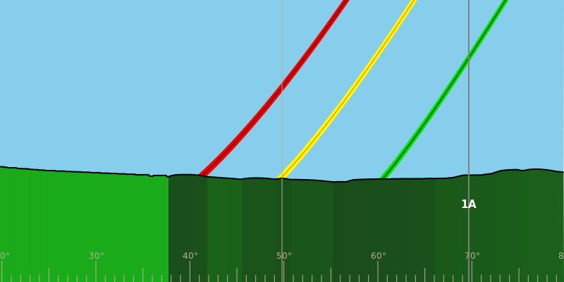
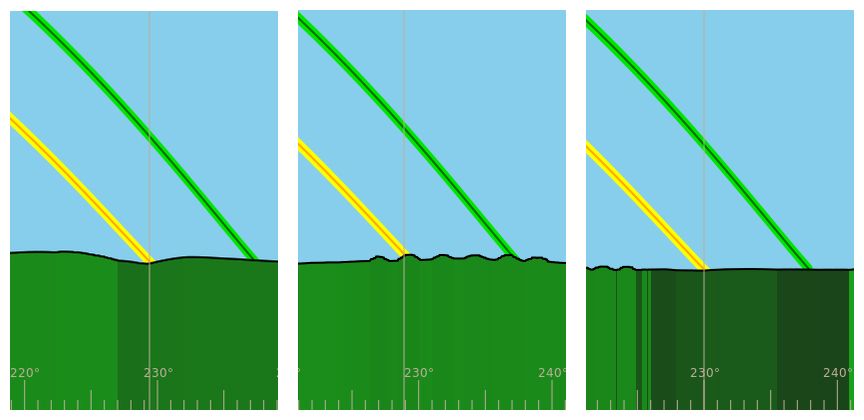
Table 9.2 summarises the distance to the horizon in the four solstitial directions for the pits of the northern arc. Clearly the most consistent views are towards the north-east. Figure 9.6 shows the horizons for the Larkhill causewayed enclosure (left), pit 11D (centre) and pit 15D (right). As the viewpoint moves downhill the solstice sunrise moves from the north to the south of Sidbury Hill. From Larkhill, Sidbury is framed by more distant horizons while from pit 15D by closer horizons. It is also apparent that the two pits furthest from Larkhill (14D, 15D) have qualitatively different views from the others. The former are in a more open landscape while views from the latter are constrained by the slope of the hill and the valley in which they lie.
It should also be noted that the views from the Larkhill causewayed enclosure vary depending on the viewpoint. From the highest point there are extensive views in most directions but in all cases Sidbury Hill is visible to the north-east and there are far views (up to 20km) to the Vale of Pewsey in the north.
| Feature | Summer sunrise | Winter sunrise | Winter sunset | Summer sunset |
|---|---|---|---|---|
| iii | 9.62 | 0.6 | 0.09 | 0.07 |
| iv | 9.47 | 0.67 | 0.31 | 0.21 |
| 10D | 9.28 | 0.27 | 0.01 | 0.01 |
| 11D | 9.15 | 0.21 | 0.56 | 0.15 |
| 12D | 8.87 | 0.12 | 0.28 | 0.16 |
| 13D | 8.7 | 0.08 | 0.82 | 0.2 |
| v | 8.61 | 0.11 | 0.46 | 0.33 |
| 14D | 8.18 | 4.47 | 1.1 | 1.61 |
| 15D | 2.52 | 4.12 | 1 | 1.83 |
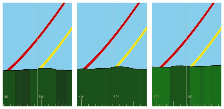
Table 9.3 shows the distance to the horizon for pit ii, which is not part of either of the identified arcs, and a viewpoint at the centre of Durrington Walls. These appear to be mirror images of one another. Both have distant views in only one direction, towards the winter sunset and sunrise respectively, with more constrained views elsewhere.
| Feature | Summer sunrise | Winter sunrise | Winter sunset | Summer sunset |
|---|---|---|---|---|
| ii | 0.15 | 0.15 | 14.09 | 0.31 |
| DW | 0.22 | 4.31 | 0.13 | 0.23 |
Internet Archaeology is an open access journal based in the Department of Archaeology, University of York. Except where otherwise noted, content from this work may be used under the terms of the Creative Commons Attribution 3.0 (CC BY) Unported licence, which permits unrestricted use, distribution, and reproduction in any medium, provided that attribution to the author(s), the title of the work, the Internet Archaeology journal and the relevant URL/DOI are given.
Terms and Conditions | Legal Statements | Privacy Policy | Cookies Policy | Citing Internet Archaeology
Internet Archaeology content is preserved for the long term with the Archaeology Data Service (ROR). Help sustain and support open access publication by donating to our Open Access Archaeology Fund.
 Home
Home