Cite this as: Savine, B. and Coates, T. et al. 2026 Late Iron Age/Romano-British Transition Pastoral Activity in the Western Environs of York: Archaeological investigations at the A1237/B1224, Wetherby Road Roundabout, York, Internet Archaeology 71. https://doi.org/10.11141/ia.71.9
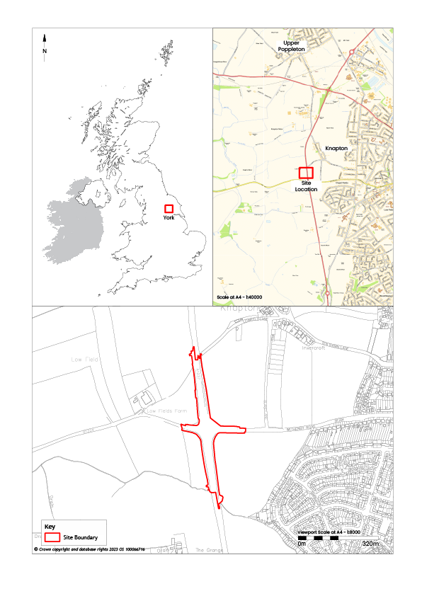
An archaeological excavation and watching brief was conducted between May and October 2018 by York Archaeology (under its previous name of York Archaeological Trust) in advance of, and during, improvement works to the A1237/B1224 roundabout, York, YO23 3NN (Latitude, Longitude: 53.956275, -1.1496270). The site was close to Acomb and Knapton, approximately 4.5km west of York city centre (Figure 1). The site encompassed the roundabout and stretches of farmland adjacent to all four roads, lying relatively flat at 21–22m AOD (Above Ordnance Datum), in an area where the underlying bedrock is sandstone of the Sherwood Sandstone Group overlain by sand and gravel of the Poppleton Glaciofluvial Member (British Geological Survey).
The investigation of this site has revealed evidence for activity in the area during prehistory, including occupation in the vicinity at least as early as the Bronze Age. There was strong evidence for the presence of a Late Iron Age/Romano-British agricultural settlement in the area. Discoveries on the site included a group of large pit-like features that have been interpreted as watering holes for livestock (an interpretation supported by environmental samples from these features), as well as a number of possible pits and ditches. A shallow ring ditch appeared to have been an enclosure. The results constitute regionally important evidence for the Late Iron Age/Romano-British agricultural landscape in a hitherto un-investigated area of York.
The site lies within a wider area of known prehistoric and Romano-British settlement activity on the York Moraine, an area of elevated ground comprising sand, clay and gravel deposited when ice sheets receded at the end of the last Ice Age (BGS, viewed on 7 August 2023). The natural topography of the area in which this site is located would have been well suited to agricultural settlement. The moraine forms a natural vantage point and provides an elevated passage through the lower-lying landscape of the Vale of York. It reaches its greatest width around Holgate and Acomb, around a mile south-west of the River Ouse (Auden 1906, 2–3; RCHME 1972, xxxvii). The well-drained sandy and loamy soils of the morainic ridge provided an agriculturally attractive landscape and it has long been speculated that the prehistoric moors, marshes and woodlands around this dominant landscape feature must have been populated to some degree, especially at the point where the Rivers Ouse and Foss breach it at York (Raine 1893, 1–2; VCH 1961, 322).
Evidence for the prehistory of York was, until recently, limited to a number of poorly provenanced 19th-century spot finds from various locations along the York Moraine. Many of these discoveries were made during the construction of the railway and railway stations in the 1840s and late 1860s (Wellbeloved 1842, 132; RCHME 1972, xxxviii; Hall 1996, 25). However, by 2006 more than 80 prehistoric find-spots had been recorded within the area of the current administrative district of York, with a notable concentration of lithic artefacts recovered from the area around the confluence of the Rivers Ouse and Foss (Fell 2006, 28).
More recent discoveries, often resulting from planning conditions attached to developments on the outskirts of the city, have added significantly to this number. To the north of Grange Farm, Upper Poppleton, some 2.5km north-west of the Wetherby Road Roundabout site, a possible settlement is indicated by cropmarks visible on aerial photographs (MNY 1198389; SE 55243 53823). The cropmarks suggest a potential roundhouse with fragmentary linear features, conceivably representing enclosures. These have never been investigated but they are thought to be potentially Late Iron Age or Roman in date. Another set of possible rectilinear enclosures is present to the west of Red Lion Bridge, Upper Poppleton, some 2.2km to the north-west of the Wetherby Road Roundabout site (MNY 1198589). Further undated cropmarks have been identified through aerial photography at Poppleton some 300m east of the Grange Farm site (MNY 1198621) (Lee 2015, 8). Recent excavations at Boroughbridge Road, 2km north-east of the Wetherby Road Roundabout site, have revealed a Late Iron Age/Romano-British agrarian landscape subdivided with field boundaries (Howlett, in prep).
The truncated remains of a possible Bronze Age round barrow were recorded during the investigations for the Poppleton Bar Park and Ride (Keefe 2013), which lies approximately 1.85km north of the Wetherby Road Roundabout site. Prehistoric remains that were not apparent from an earlier geophysical survey were found during evaluation work at the British Sugar Site, which lies 2km north-east of Wetherby Road Roundabout (McComish and Milsted 2014; Bruce et al. 2014; O'Brien and Bruce 2015). Evidence for Romano-British activity has also been recorded at the Poppleton Bar Park and Ride (Keefe 2013) and at Wheatlands, opposite the former Civil Service sports ground on the south side of Boroughbridge Road, 1.7km north-east of the Wetherby Road Roundabout site (Wells 2015).
The most extensive evidence to date for prehistoric activity on the York moraine comes from investigations 3km south-east of the city at Heslington East, where evidence has emerged of a complex wetland landscape of post-glacial springheads and palaeochannels, associated with evidence for activity from the Mesolithic, Neolithic, Bronze Age and Iron Age periods (Roskams and Neal 2020).
The range and distribution of newly identified prehistoric sites on the York Moraine indicates a landscape that was widely settled and exploited by the start of the Roman period. Cropmarks of associated linear and pit-like features have been observed through aerial photography within the fields that surround the stretch of the A1237/B1224 road investigated as part of this project (York Historic Environment Record). Although these features located outside of the limit of the site boundary for the road expansion works have not previously been investigated, it seems likely, considering the findings at this site, that further archaeological assets relating to the Iron Age (and perhaps earlier settlement) remain to be identified in the surrounding landscape.
Although some evidence for Roman settlement has been found in Acomb (Richardson 1963, 3), there is currently no evidence for Roman activity in the immediate vicinity of the site. During the Roman period the site was approximately 1.15km south-west of the road between York and Aldborough (Ebvracvm and Isvrivm), designated as Road 9, and was 3.35km north-west of the road between York and Tadcaster (Calcaria), Road 10 (RCHME 1962, 2). The area was therefore not closely linked to the main Roman transport routes. A boundary ditch discovered on the northern side of Boroughbridge Road suggests activity of early Roman to 4th-century date in the vicinity (O'Brien and Bruce 2015).
The site was formerly within the Wapentake of Ainsty but was incorporated into the City of York in 1937 (Richardson 1963, 3). The place name of the village to the west of the site, Knapton, means ‘the farmstead of Cnapa' and is derived from the Old English personal name Cnapa and the suffix tun, meaning manor or farm (Mills 2011, 280–1). The village is mentioned in the Domesday Book of 1086, and in the 16th century the village was a detached part of the parish of Holy Trinity, Micklegate (VCH 1961, 311–21).
The surrounding farmland has been subject to open field system agriculture since the medieval period. An oblique aerial photograph shows a possible rectangular enclosure enclosed by ridge and furrow cultivation on the west side of Knapton village. It is single-ditched, and measures approximately 40m by 35m (Monument Number 1199339; Latitude, Longitude 53.962083, 1.1513777). Aerial photography and satellite imagery have revealed other ridge and furrow cropmarks throughout the local landscape.
The areas within the development boundary and the immediate surrounding area appear to have been arable farmland during the post-medieval period, with OS maps identifying various field boundaries. Later phases of ridge and furrow are also visible through aerial photography (York Historic Environment Record).
The general objective of the fieldwork can be summarised as the monitoring of site stripping, ground reduction operations and any other intrusive groundworks associated with the project and to identify any areas where further mitigation was necessary. This was done in order to identify, investigate and record any archaeological deposits, structures or features that were at risk of being impacted by the road scheme, thereby enabling an appropriate level of preservation by record.
The aim of the fieldwork was to establish the presence, date, nature, extent and condition of any archaeological deposits, features or structures present.
The following research questions were suggested by the results of the assessment report:
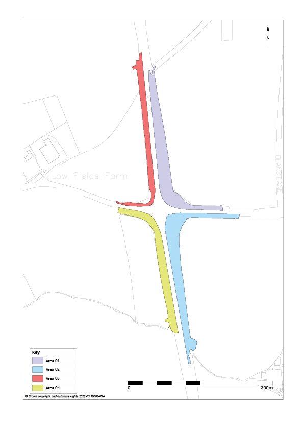
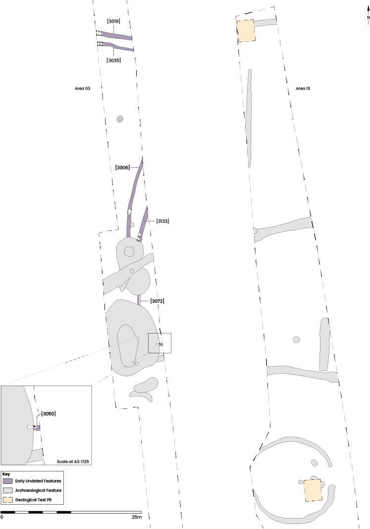
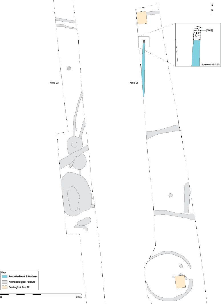
All soil removal was carried out by the principal contractor using a 22-tonne tracked excavator fitted with a toothless bucket. The initial phase of ground reduction across the site involved removal of topsoil, which generally measured around 0.3m thick. A watching brief was then conducted during the removal of sub-soil, usually measuring 0.25–0.3m thick, which exposed the top of naturally occurring geological deposits, or where present, the top of archaeological deposits and features, as was the case in Areas 1 and 3 (Figure 2). No archaeological deposits were apparent in Areas 2 and 4. No further work was undertaken in these areas.
Where archaeological features were distinguishable, these areas were upgraded from watching brief conditions to a full excavation (Figure 3). The excavation areas were hand-cleaned to enable identification and definition of archaeological features.
A sampling strategy was established involving the excavation of all features to a minimum of 50%. For linear features this required excavations of slots at 1m intervals, with the exception of features that were too indistinguishable or were known to relate to modern field boundaries as shown on recent OS maps. Significant features that were encountered during excavation were initially 50% excavated and recorded, and then fully excavated to expose the cuts of these features to their full extents.
The top of superficial geological deposits was exposed in Areas 1, 2 and 3. The naturally occurring material comprised light yellowish-orange sand with lenses of clay and silt running thorough it in places. Typically, these deposits were encountered at 0.55–0.6m BGL, a range of 20.74–20.9m AOD across the site.
A small assemblage of worked flint was recovered from the site. Three lithics, comprising two blades and a fragment of associated core material were found in close proximity in deposit (3059), which was a secondary fill in watering hole [3113]. Although the lithics date to the Neolithic, pottery finds date the silting of the watering hole to the Late Iron Age/Romano-British period. Consequently, the lithics must be residual, although they do indicate human activity in the vicinity at that earlier time. Additionally, a single flint side-scraper dating to the Neolithic/Early Bronze Age was recovered during the topsoil strip in Area 1.
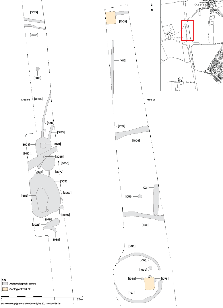
At the southern end of Area 3 was a possible gully [3038], which curved away from a rounded southern terminus to the west where it petered out (Figure 4). The gully was 0.83m wide and 0.21m deep with a shallow U-shaped profile. It contained a single fill (3037), which comprised light grey silty sand with orange sandy mottling. No dateable material was found within it, but it was cut on its northern edge by another feature in this phase, pit [3023] (described below).
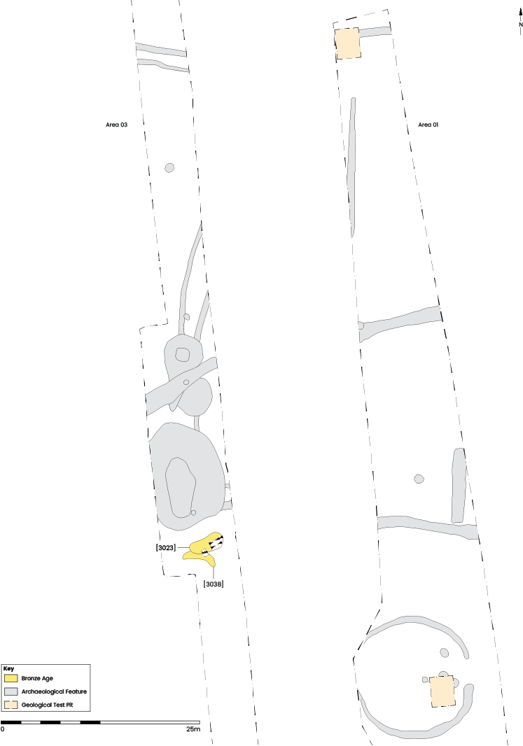
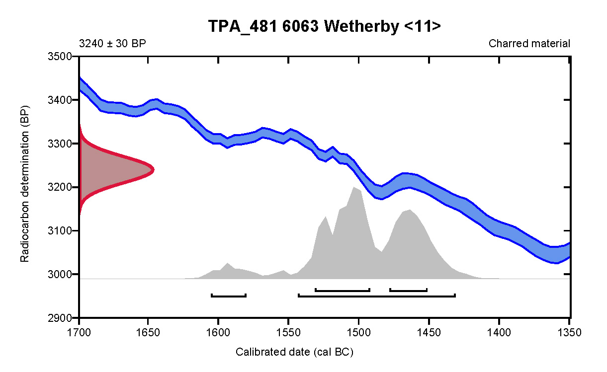
The earliest securely dated feature on the site was large oval pit [3023] situated at the southern end of Area 3. This feature was 0.77m deep and contained three grey silty sand fills. All of these fills contained charcoal and pebbles, some of which had been fractured by exposure to heat. A rubber-stone for a saddle quern SF12 was found in the basal fill (3022), which also contained fragments of roundwood charcoal identified as Corylus avellana or Common Hazel, radiocarbon dated to 3240±30 BP (Beta-663476), corrected to 1545–1433 cal BCE (91%), placing the date of this feature on the cusp of the Early and Middle Bronze Ages (Figure 5).
Several gullies identified in Area 3 presented no direct dating evidence (Figure 6). The majority of these features had a direct stratigraphic relationship with one or more of the Late Iron Age/Romano-British watering holes. For example, the gullies in the southern and central part of Area 3 all appear to have either been cut by one or more of the watering holes present there, or had silted up before the upper part of the watering holes had done so, indicating that they were either earlier than, or potentially contemporary with, the Phase 4 watering holes.
Also cut by watering hole [3004] was gully [3006] which extended along the same north-east/south-west axis as gully [3133], situated just 1.75m to the east. Similar silting was present within both gullies, comprising mid-greyish brown sands, but their depths were quite different, with [3006] measuring 0.25m deep as opposed to the 0.1m depth of [3133].
Close to the north end of Area 3 were two more close-set parallel gullies [3019] and [3035], here separated by approximately 1m. Aligned close to east/west it is possible that they formed the northern boundary of an enclosure bounded to the east by gullies [3006] and [3133]. Notably, neither pair of gullies were observed to extend into Area 1, 18.5m to the east. The southern gully [3035], had a U-shaped profile, shallow 0.1m depth and was 0.7m wide, a strikingly similar form to gully [3006], which was also present on the internal side of the potential enclosure. Gully [3019] was a little wider, at 0.81m, and significantly deeper, measuring 0.37m; it also contained several fills largely made up of grey and brown silty sands, as such displaying broadly comparable traits to gully [3133] which also contained multiple fills and possessed a deep U-shaped profile.
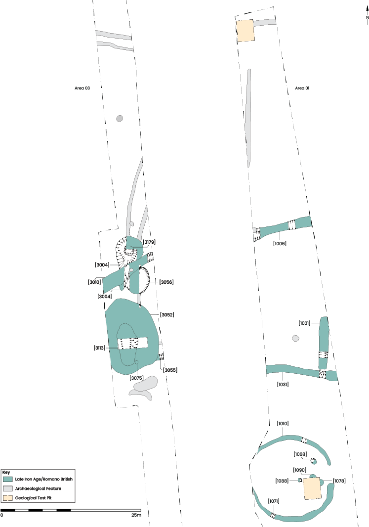
Late Iron Age and Roman pottery was present in a range of features found across Areas 1 and 3, including a ring gully enclosure, two linear ditches and five watering holes (Figure 7). A small assemblage of ironworking slag and possible non-ferrous debris was also present in some of the features allocated to this phase. Radiocarbon dating carried out on charcoal and preserved wood recovered from some of these features has helped to outline a picture of use, maintenance and eventual abandonment.
Ring gully enclosure
At the southern end of Area 1 was a shallow ring gully with a 3.2m wide gap on its eastern side. It had been truncated to the west by a modern drain separating the gully into northern and southern halves, individually recorded as [1010] and [1071] (Figure 8). The maximum diameter to the outer edge of this feature was 15.5m and it ranged in width from 0.45–1.13m and depth from 0.07–0.29m. The southern half of the gully was generally found to be wider and deeper than its northern counterpart and the fill was a dark grey silty sand, as opposed to light brownish-grey. In addition, while little was found in the fills of the northern half, the southern half contained heat-fractured cobbles, burnt bone, charcoal, part of a hearth lining, part of a Millstone Grit lower rotary quern SF1 and pottery sherds. The cobbles were found in sufficient quantity there to suggest they had been intentionally placed, perhaps to aid drainage. Rotary querns were in use in Britain from the mid-Iron Age into the Roman period, while pottery recovered from the southern half of the enclosure dates the silting of that feature a little more closely to the Late Iron Age.
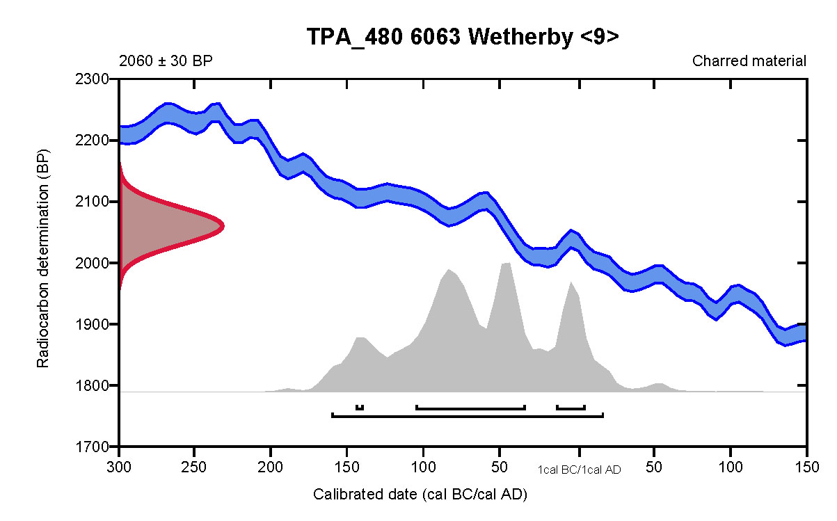
Inside the enclosure, clustered near the entrance, were four pits. Three of the pits, [1008], [1068] and [1090], were quite similar, being either oval or circular in plan with shallow U-shaped profiles. They ranged in size from 1.20–1.28m in diameter and 0.24–0.39m deep and contained fills comprising mid-brownish grey or mid-orangey brown silty sand with charcoal flecks. The fourth pit [1088] was closest to the centre of the enclosure and was different in form from the others. It was square in plan, with rounded corners, vertical sides and a flat base. It measured 0.62m across and was 0.26m deep (Figure 9). The single fill (1087) consisted of dark greyish-black sandy silt and cobbles, some of which had been fractured by heat, and contained a large quantity of charcoal, which was subsequently radiocarbon dated to 2060±30 BP (Beta-663475), corrected to 162 cal BCE to 17 cal CE (95.4%) (Figure 10). This feature had initially been interpreted as a hearth; however, the sand below the pit showed no evidence of scorching, suggesting that the fill materials had been deposited after they had cooled.
![Pit [1088], facing west. 0.1m scale units](images/figure9.jpg)
The presence of charcoal and fractured stones in the pits and southern part of the gully suggests some sort of processing involving heat had occurred either in or near the enclosure during the Late Iron Age.
Watering holes
Clustered together in the centre of Area 3 were five large pits, the form and content of which suggest that they were watering holes, indicating that keeping livestock was central to land use in the vicinity at this time. Wet, anaerobic conditions within these features resulted in the preservation of organic materials, including insects, plant macrofossils and, in the case of two of the watering holes, the remains of timber revetting structures. The preserving conditions have not only revealed something of the local environmental conditions but also give an insight into the use and maintenance of these features. Crucially, radiocarbon dating of timber present in early fills has established when the watering holes were in use, as opposed to pottery dates, which were only available for the upper fills and which had most likely accumulated during the decline in use and eventual abandonment of these features.
The northern watering holes
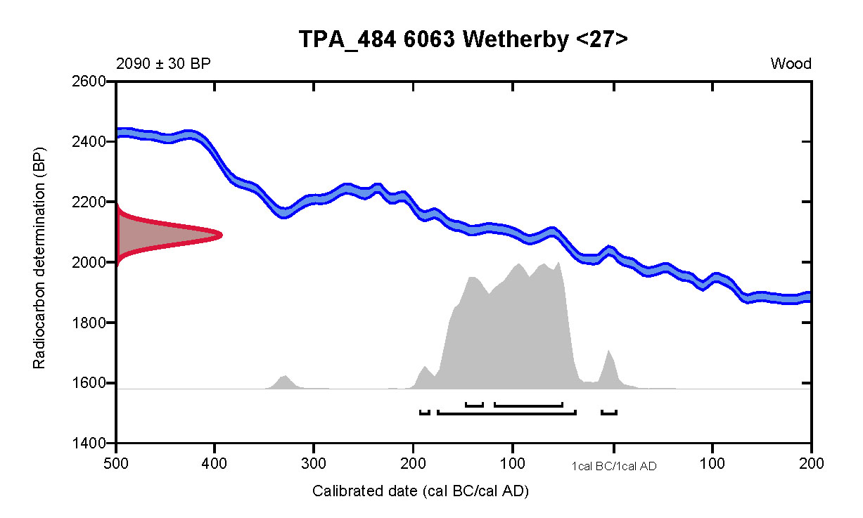
The first of the three watering holes to the north was [3056] (Figure 11). It was sub-oval in plan, and measured 5.6 × 4.7m across and 1.51m deep. The soft sandy edges of the pit had been consolidated with a wattle lining (3149), behind which light bluish-grey clay and pebbles (3170) had been packed (Figure 12). Several fragments of Quercus spp. board had also been utilised within the revetting structure, and it may be that the boards represent reinforcement of the lining or might have been part of a step or working platform within the feature. Radiocarbon dating carried out on wood from the wattle lining returned a date of 2090±30 BP (Beta-663479), corrected to 178–38 cal BCE (91.6%) (Figure 13).
![Watering hole [3056], facing west. 0.5 and 0.1m scale units](images/figure11.jpg)
Along with the stakes and rods forming wattle lining (3149), two wooden artefacts were also present. One was cut from radially-faced Quercus spp. heartwood ST30, and had been more carefully finished than any of the stakes or rods and is interpreted as a peg. The other was a wooden bowl face turned from a halved Alnus spp. log, SF21.
Situated at the base of watering hole [3056] was a 0.3m thick deposit of laminated sandy silts (3148). This silting contained plant macrofossils indicative of damp or waterside conditions, along with other taxa typical of open ground or grassland. In addition, an abundance of insect remains were preserved and are typical of those expected in the presence of livestock.
A series of deposits (3057), (3062–70), (3088–9) and (3107), filled the upper 0.85m of watering hole [3056], suggesting that it had gradually silted up towards the end of its use. Again, taxa indicative of standing water and animal dung were present. A Late Iron Age to Romano-British date for the closing stages of use of this watering hole is indicated by the presence of prehistoric handmade tradition pottery in deposits close to the top of the feature, including its upper fill (3057). Other waste material, in this case flowed iron slag, was present in one of the other upper fills (3064).
Watering hole [3056] was succeeded by watering hole [3004], which cut into its upper fills along its northern and western edges. Measuring 6m north/south and 4.58m east/west, watering hole [3004] was sub-oval in plan, 1.45m deep and contained a series of deposits comprising light, mid- and dark grey silty sands, giving the impression that it had steadily silted up. A roughout of an upper beehive quern SF17, worked from Millstone Grit, was found in (3037), one of the lower fills of this feature.
A substantial effort to maintain access to water then appears to have occurred, with the cutting of a steep-sided, flat-bottomed pit into the centre of the feature. Cut [3179] was at least 1.3m across and extended down near vertically 0.6m to within 0.2m of the base of the earlier watering hole cut [3004] (Figure 14). The first deposits to build-up at the base of [3179] were mid- and dark grey sands with lenses of organic silt, Contexts (3161–2), overlying which was a highly organic deposit (3158). The upper fills were substantially drier and lacked the organic content of those closer to the base. A single sherd of Late Iron Age pottery was recovered from fill (3154).
![Watering hole [3179], facing north. 0.5m scale units](images/figure14.jpg)
Samples recovered from the basal fills of both [3004] and [3179] preserved a range of plant macro fossils, pollen and insects, which provide evidence for grassland or open ground with hedgerows or woodland in the vicinity, while nettles and alder appear to have been growing in, or adjacent to, the watering hole.
The southern watering holes
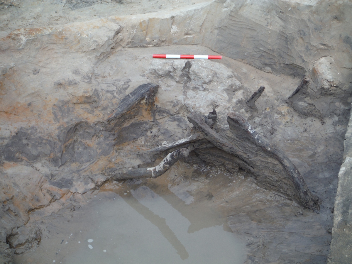
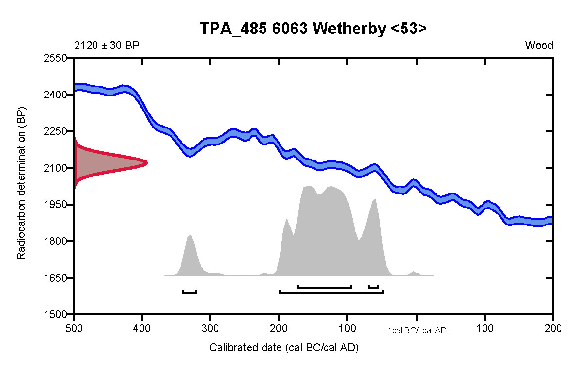
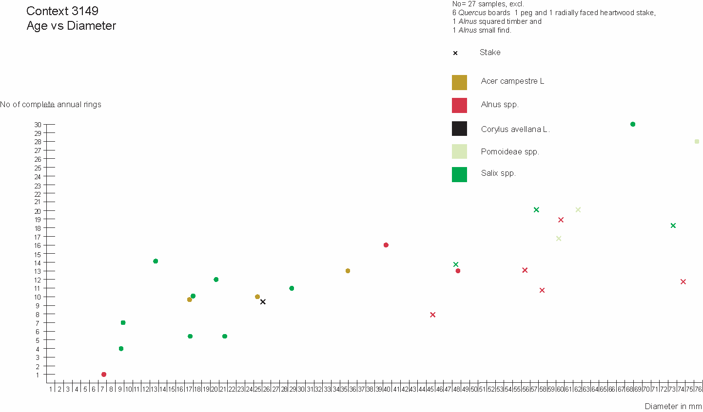
The first of the southern watering holes was by far the largest. The cut of watering hole [3015]/[3052] was sub-oval in plan and measured 13.9m north/south and at least 8.66m east/west, although the western side of the feature extended beyond the edge of the site. Unfortunately, only the upper 1.7m of the pit could be safely exposed and accessed for investigation and ultimately it was not possible to reach the base. The sides of the feature had been supported with a wattle lining, but not until silts had already accumulated in the base. The revetting structure (3176) comprised 14 roundwood stakes around which 90 roundwood rods had been woven (Figure 15). The relative ease with which the wattle could be removed suggests that the stakes had been driven only into the basal silts (3177–8), which in any case could only be partially excavated, and that two Quercus spp. timbers, ST148 and ST151, and two Alnus spp. roundwood stakes found within (3177) may well have originally been part of the lining, later falling away as it degraded. Part of the wattle lining was selected for radiocarbon dating, producing a result of 2120±30 BP (Beta-663480), corrected to 201–49 cal BCE (89.6%) (Figure 16).
![Wattle lining (3176) in watering hole [3015]/[3052], facing east. 0.1m scale units](images/figure15.jpg)
It was possible to examine in detail some of the later silting along the eastern side of the feature. Here a sequence of dark grey silty sands and silty clays were interspersed with light brownish-yellow and mid-brownish grey silty sands with a laminated appearance, indicating a gradual build-up influenced by seasonal fluctuations in water levels and associated erosion. Late Iron Age pottery was present in three of these deposits, Contexts (3130), (3132) and (3175). As with the watering holes to the north, plant and insect remains were recovered and present the same picture of localised standing water and livestock regularly accessing the watering hole from open ground or grassland in the surrounding area.
The spring in this area must have been a reliable source of water. Even after watering hole [3015]/[3052] had silted up, a considerable amount of that material was cleared out of the centre of the feature and the watering hole re-cut over an area measuring 7.43m north/south by 3.5m east/west and extending down 1.48m. The re-cutting of the watering hole was recorded as [3113].
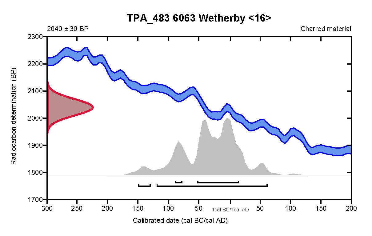
It seems likely that a posthole [3075] related to maintenance or re-establishment of the watering hole at this time. It was situated at the western end of ditch [3055] and was close to the southern end of the re-cut watering hole [3113]. Roundwood charcoal recovered from (3076), the fill of posthole [3075], has been radiocarbon dated to 2040±30 BP (Beta-663478), corrected to 121 cal BCE to 62 cal CE (92.5%) (Figure 17). There is some cross-over with the date range produced by the timber lining of the earlier phase of watering hole [3015]/[3052], but there is a better fit with material recovered from deposits within watering hole [3113].
An effort was made to consolidate the base of the new watering hole [3113], presumably to ease access for livestock, with the laying of a cobble surface (3172) (Figure 18). The deposits that accumulated above the cobbles were more homogeneous than those present below it that filled [3015]/[3052]; they were also drier and less organic. However, plant macrofossils and insect remains were preserved in (3171), a substantial fill above the cobbles, comprising dark grey silty clay, and repeat the pattern of plants and insects thriving in nitrogen enriched soils, as well as the presence of damp or waterlogged conditions and grassland in the locality.
![Surface (3172) in watering hole [3015]/[3052], facing north-east. 0.5m scale units](images/figure18.jpg)
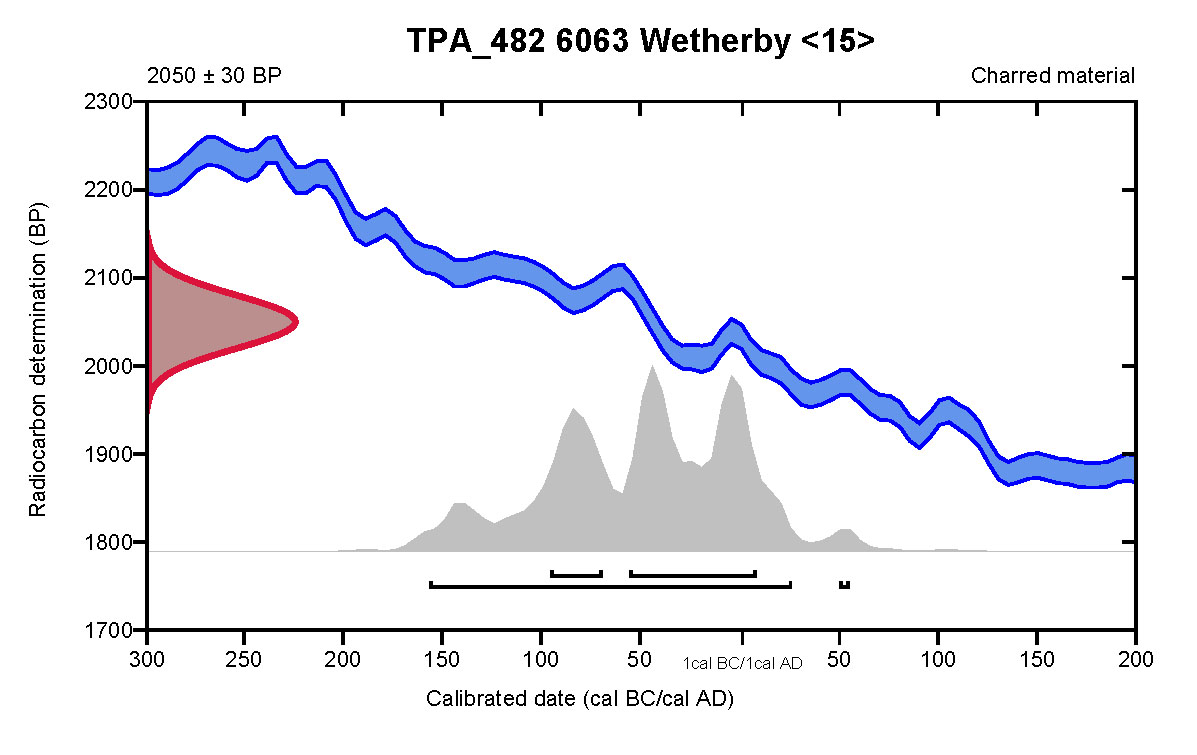
Deposit (3171) extended across the main bulk of the feature and to within 0.4m of ground level. It was found to contain an abundance of charcoal fragments, one fragment of which was Corylus avellana (Common Hazel), radiocarbon dated to 2050±30 BP (Beta-663477), corrected to 158 cal BCE to 26 cal CE (95.4%) (Figure 19). Pottery recovered from the same deposit and (3077), a corresponding deposit recorded at a higher level in section, was interestingly somewhat later, being early to mid-Roman in date and perhaps as late as the early 3rd century. More pottery was recovered from deposits filling the upper extent of the feature. Prehistoric handmade tradition pottery and a sherd of Roman oxidised ware were found in watering hole [3113] fill(3059), while a sherd of 2nd-century Central Gaulish samian ware and a sherd of early to mid-Roman Ebor ware were found in (3114), an upper fill of the same feature. The broad range of dates presented by the pottery and radiocarbon analysis hints at sustained use over a prolonged time-scale, spanning the transition from the Late Iron Age to Romano-British period.
Land division
The lines of two ditches were found approximately 11m north of the ring gully enclosure. The first extended on an east/west axis across Area 1 as ditch [1031], which was also adjudged to continue into Area 3, there recorded as ditch [3055], in total covering a distance of 37.5m including the 18m gap between the two areas. Ditch [1031] had a V-shaped profile; it crossed the full 12.6m width of Area 1, was 1.89m wide and up to 0.54m deep. The ditch contained a series of largely mid- to dark grey and brown silty sand fills interspersed with lighter yellow and orangey-brown sands, suggesting a gradual accumulation of material periodically washing into the feature. Three sherds of Late Iron Age pottery were recovered from one of the upper fills (1038), and a fragment of a hearth bottom SF6, was also found in a corresponding deposit (1032), also forming an upper fill of the ditch at a different intervention. The upper fills were observed to have a greater stony component than those below and may have reflected dumping of waste material into the ditch at the end of its use.
Ditch [3055] continued along the line [1031], extending 6.2m into Area 3 where it appears to have been cut at its western end by a watering hole [3015]/[3052]. It otherwise bore a number of similar characteristics to ditch [1031]; it was 1.47m wide, 0.52m deep with a V-shaped profile and five fills, Contexts (3078–83), alternating between dark sandy silts and lighter sands. After ditch [3055] had silted up posthole [3075] was cut close to its western end, where watering hole [3015]/[3052] had cut across, truncating that end of the ditch. However, rather than its placement being dependent on the location of the ditch the posthole probably relates to [3113], a re-cutting of the watering hole.
Close to the eastern side of Area 1 was a second ditch, here extending on a perpendicular line to ditch [1031]. Ditch [1021] terminated just 0.22m north of ditch [1031] and extended 9.4m on a north/south axis, terminating at the eastern edge of the trench. The profile of the ditch varied slightly, having steep sides and a fairly flat base close to its ends but with more of a V-shaped profile and a stepped western side across its main body. It ranged in width from 1.38–1.66m and in depth from 0.38–0.50m. Five sherds of Iron Age pottery were found in (1064), the upper fill at the northern terminus of the ditch.
A third ditch may also have been Romano-British in date. Gently curving from the south-west in Area 3 and possibly continuing through to a more easterly alignment in Area 1, this feature was situated approximately 22m north of ditch [1031] and bisected the northern watering holes [3004] and [3056]. Overall, it extended for nearly 39m, with an 18m gap where the A1237 road passed between the two areas of excavation. Where it passed through Area 1 it was recorded as [1006] and was found to be 1.30–1.84m wide and 0.6–0.8m deep. To the east it had a V-shaped profile but this changed to a less well-defined, broader U-shape, close to the western side of the area. Further to the west, in Area 3, it was recorded as ditch [3010] and became increasingly wider, measuring up to 3.9m across while maintaining a depth of approximately 0.6m.
Only two sherds of pottery were found in this feature, a single piece of Roman pottery from the basal fill (1025) and, from the main bulk of the ditch fill (1023), a small abraded sherd of late 11th–12th century Yorkshire Gritty ware; however, this may have been intrusive.
Evidence for definitively medieval activity at the site is sparse. Pottery of this period, totalling nine sherds, was found within topsoil across Area 1 and in three discrete features. In the case of the latter, however, in each case there is reason to suggest that the sherds were intrusive. Only a single, small, abraded medieval sherd was found in ditch fill (1023). Four sherds were recovered from (3011), one of the upper fills of watering hole Context [3015]/[3052] that pre-dates a re-cutting of watering hole recorded as [3113], which is securely dated to the Romano-British period. Pit [1059] contained only one dateable find, a small, abraded sherd of 12th–14th century date from its upper fill. This circular feature, which measured 1.14 in diameter and 0.29m deep, was situated approximately 6m north-west of where ditches [1021] and [1031] converged. The lower pit fill (1058), contained waste materials derived from heating or burning, including partially vitrified clay, charcoal and heat-fractured stones alongside several rounded fragments of vesicular lava (SF2) which are likely to have originated in Mayen, Germany. Imports of this material to Britain could have occurred at any time since the Roman period. The possibility therefore exists that the sherd from the upper fill was intrusive and this feature pre-dated the medieval period.
Towards the northern end of Area 1 was a north/south aligned ditch [1012] (Figure 20). No dateable material was recovered from it, but it corresponded to a field boundary depicted on early Ordnance Survey mapping (OS 1850 6 inch: 1 mile map sheets, Yorkshire 173), and probably represented a post-medieval or modern field boundary.
A second ditch very likely falls within this phase. Found at the south end of Area 3, ditch [3044] was aligned east/west and clay tobacco pipe was found within it. Unlike ditch [1012] no analogous feature is represented on 19th-century or later mapping.
A handful of features could not be definitively assigned to any of the above phases of activity either by artefactual or other dating evidence or by stratigraphic relationships.
Ditch [1008] ran east/west at the far northern end of Area 1. It was 0.97m wide and 0.34m deep with V-shaped profile and contained a single mid-brownish grey silty sand fill. Its form was similar to that of the Romano-British ditch [1006] located 35m to the south, although it did not display indications of initial erosion and silting seen at the base of [1006].
Four discrete features were present that did not yield any dateable material. All were oval or circular in plan and measured between 0.59–1.08m in diameter and 0.17–0.31m deep, with shallow U-shaped profiles. These were probably all small pits rather than postholes given that they did not relate to any obvious structures.
Pit [3041] was situated in the northern part of Area 3 approximately 12m south of the double gully enclosure [3019]/[3035] and contained mid-brownish grey slightly silty sand and heat-fractured cobbles.
Situated a further 18m south was posthole [3017]. It cut into the edge of gully [3006] and contained a single fill comprising mid-brownish grey slightly silty sand and large, fragmented cobbles.
Pits [1027] and [3085] both cut into the fills of ditch [1006]/[3010] so must have post-dated the silting up of that feature, which occurred during the medieval period at the latest.
In total, 69 sherds of pottery weighing 1146.8 grams (Table 1) were recovered from the site. The assemblage contained predominantly handmade pottery (40 sherds), produced using prehistoric tradition handmade and wheel-turned techniques (mostly Late Iron Age but continuing into the Romano-British period), Romano-British wares (19 sherds), medieval (9 sherds), and one sherd of modern pottery (a rim from a late 19th to early 20th century food jar).
| Period | Count | Weight (g) |
|---|---|---|
| Late Iron Age to Romano-British (prehistoric tradition made pottery) | 40 | 854 |
| Roman | 19 | 237.7 |
| Medieval | 9 | 50 |
| Modern | 1 | 5.1 |
| Grand Total | 69 | 1146.8 |
A total of forty sherds representing a maximum of twenty vessels of handmade pottery produced in a prehistoric tradition were recovered. While these vessels have a prehistoric character in form and fabric composition, these ware types continued to be produced in northern England into the Roman period and later (Cumberpatch 2021, 2; Roskams and Neal 2020).
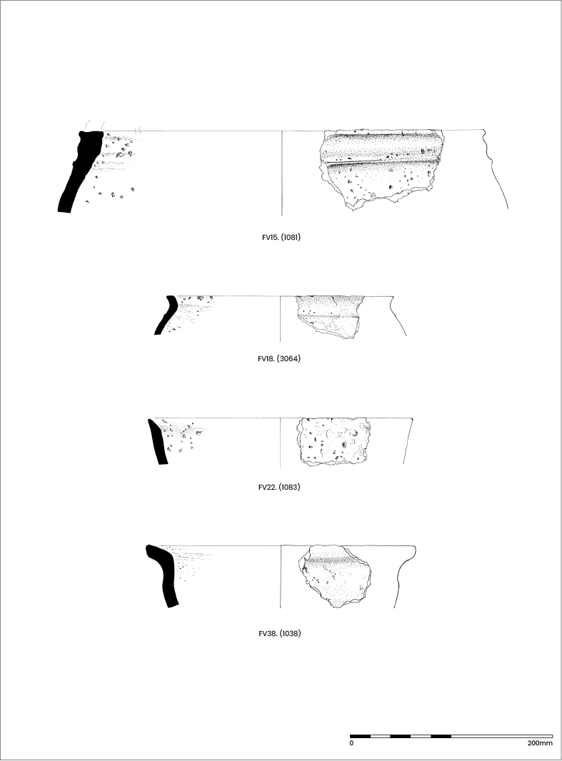
Although many sherds were undiagnostic body sherds, rim and body sherds were recovered where it was possible to identify vessel form. These included a large and unusual bucket-type vessel with a thick rim and beaded decoration to the neck (FV15, from (1071), a fill in ring gully [1010], Figure 21), a relatively thin-walled jar (FV18, Figure 21) similar to an example from Dalton Parlours (Sumpter 1990, no. 1, 130, fig. 94, 129) found in watering hole Context 3056, a thick-bodied wedge-rim jar (FV38, Figure 21), and a bowl/jar (FV22, from (1071), a fill in ring gully [1010], Figure 21). The range of fabrics and, albeit limited, forms recovered, are generally consistent for the region and indicate a Late Iron Age to Early Roman date. While there is debate about the longevity of production for these types in northern England (e.g., Cumberpatch 2021, 2), the more robustly dated Romano-British types recovered (see below), do not date beyond the early 3rd century CE, and most likely represent 2nd century CE activity. The handmade jar and bowl/jar recovered were common types; however, the large, thick- and flat-rimmed bucket-type vessel (FV15) is rather unusual, and a similar example has yet to be found.
A total of nineteen sherds of Romano-British pottery were recovered. This is a small assemblage, with a limited range of forms and fabric types present. The bulk of the assemblage were coarse wares, including seven sherds in oxidised fabrics (Ebor products (late 1st to early 3rd century CE) and other unsourced oxidised ware) and eleven sherds of a single globular flagon (ID4) in white-slipped oxidised ware (another Ebor product dating from approximately 120 to 200 CE). A single base sherd of Central Gaulish samian ware (ID3) vessel was recovered, dating to the 2nd century CE.
The bulk of the Romano-British pottery, seventeen of nineteen sherds, were recovered from the fills of watering hole [3113] (a single handmade sherd weighing 11.9g was also recovered); the remaining sherds were recovered from watering hole [3015]/[3052] (one sherd weighing 7.9g) and ditch [1006] (one sherd weighing 12.4g, along with a sherd of medieval pottery).
Nine sherds of medieval pottery weighing 50g were recovered, five from three contexts in Area 1 and four from watering hole [3015] in Area 3. Three sherds from the topsoil (1000) in Area 1 included a body sherd of a Yorkshire finely gritted ware vessel dated to the late 12th to early 13th century, a body sherd from a Beverley 01 type ware vessel, and a base sherd of a Humberware jug with stacking scar, both dated to the 13th to 15th century. Two other sherds of medieval pottery from Area 1 included a base sherd from a Yorkshire gritty ware vessel from fill (1023) in ditch [1006], dated to the late 11th to 12th century, and a body sherd from a Gritty ware vessel from fill (1057) in Pit [1059], dated to the 12th to 14th century.
All of the medieval sherds from Area 3 were recovered from watering hole [3015]/[3052]; these comprised four body sherds of Oxidised gritty ware, dated to the 12th to 14th century.
A single rim sherd from a late 19th to early 20th century food jar was recovered from topsoil (1000).
The prehistoric tradition handmade pottery fabrics are broadly comparable with a wide range of sites in the region of late Iron Age to Roman period date, for example Dalton Parlours (Sumpter 1990), Wattle Syke (Cumberpatch 2013), Swillington Common and Parlington Hollins (Evans 2001), Ferrybridge (Evans 2005), Heslington East (Didsbury unpublished appendix to Roskams and Neal 2020), and sites further afield in East Yorkshire such as North Ferriby (Tinsley 2018), the A165 Reighton Bypass (Cumberpatch 2007), and recent work by Cumberpatch (2017; 2018; 2020; 2021) in North Yorkshire, in addition to many other sites across the Yorkshire region.
The Romano-British pottery is likely to represent local and/or regional products, and the presence of York region Roman products (i.e., Ebor wares, Monaghan 1997, 869–80) is not surprising given the proximity of the site to the city of York. The only imported product was a single sherd of Central Gaulish samian ware. Aside from the samian vessel and a flagon (both used for dining), the pottery types were utilitarian in character, probably jars for storage and cooking.
The medieval pottery represented wares that are very common finds from excavations in York (Mainman and Jenner 2013). Medieval pottery was recovered in very low quantities, represented only by small and abraded sherds, suggesting that this material represents evidence for medieval activity in the vicinity of the site, where pottery has become incorporated into the fills of earlier features through post-depositional processes/redeposition.
While this was a small pottery assemblage including later prehistoric, Romano-British, and medieval pottery, material was recovered from features that may be chronologically significant, potentially representing distinct phases of activity. Handmade pottery was recovered from six features where later dating material was not present, particularly ditches [1021] and [1031], and ring gully [1071], and watering holes [3015]/[3052], [3056] and [3179], potentially indicating that these features represent an earlier (Late Iron Age) phase of activity at the site.
The pottery types recovered represent low-level domestic subsistence activity typical of rural sites in the region during the Late Iron Age and Roman periods (e.g., Evans 2001), with a limited range of forms present, especially for the Roman-period material. The size and condition of the medieval sherds, which were small and abraded, suggest that these have been subjected to post-depositional movement in the archaeological record and, while providing evidence for medieval activity in general in the vicinity, are redeposited/intrusive in the upper fills of earlier features. Although the overall pottery assemblage was small, prehistoric handmade and Roman pottery were recovered from distinct features, possibly indicating that these result from two (or more) phases of activity at the site; however, the long date ranges for handmade pottery in northern England makes accurate dating difficult and one must be cautious when making conclusions about dating and phasing.
The excavation produced six pieces of flint, four of which were worked and two of which were natural pieces (Table 2).
| Small Find No | Context | Type | Raw material | Dating |
|---|---|---|---|---|
| SF3 | (1000) | Side scraper | Till flint | Neolithic/early BA |
| SF3 | (1000) | Natural | - | - |
| SF8 | (3011) | Natural | - | - |
| SF13 | (3059) | Blade | Till flint | Neolithic |
| SF13 | (3059) | Blade | Till flint | Neolithic |
| SF13 | (3059) | Angular shatter | Till flint | - |
In analysing the typological and technological characteristics of the lithic material definitions outlined by Preston (2011) and Butler (2005) were followed. Cortex groups were based on definitions provided by Andrefsky (2005).
All of the worked lithics (n=4) were manufactured using Till flint, also known as Drift flint (Preston 2011) or speckled flint (Conneller 1999) by some researchers.
The source of this flint is considered to be the Holderness till of East Yorkshire and Durham, containing flint eroded by glacial action from Cretaceous deposits exposed on the then dry North Sea floor, off the east coast of northern England. A second possible source has been proposed, namely the red chalk found just north of Flamborough Head. However, the glacial action that caused the formation of these deposits may have also scattered nodules as glacial erratics (Conneller 1999).
Henson (1982) has noted that although this flint is formed within chalk, it is not native to Yorkshire and is derived from a secondary source, found within the boulder clays and till deposited by glacial action in the Devensian period. The heterogeneous nature of this raw material and its variety of colours and hues probably results from its secondary source origin.
An origin within the northern part of the Vale of York, known as the Vale of Mowbray, has been suggested (Manby 1979). These deposits are also present to the south east and north east of York within the Vale of York (BGS website).
All of the worked lithics were recorded as Cortex Group 4 (0% cortex) n= 4.
The only tool recovered was a side scraper with abrupt retouch on the right lateral margin, recovered from topsoil (1000). This was manufactured on a flake blank made from Till flint with a white patina. The scraper probably dates from the Neolithic or Early Bronze Age (Butler 2005).
Two flint blades were recovered in close proximity, within watering hole [3113] fill (3059). They were both manufactured on Till flint coloured with a similar orangey-brown patina, and may have been detached from the same core.
A single piece of shatter was found with the two blades within (3059). This probably represents a waste piece detached during core reduction.
The small assemblage of flint recovered shows that there was some activity during the Neolithic and possibly Early Bronze Age within the area of the site. It is, however, not possible to make any conclusions about the nature of this occupation given the small number of the recovered lithics, and that all were residual in later features.
The wood had been preserved in waterlogged anaerobic conditions and it appears that these conditions were maintained up until exposure during excavation. Most of the material was in good condition, with abraded surfaces owing to the sandy nature of the local soils. Some drying and erosion had taken place at those uppermost ends of timbers that had been closest to the interface between waterlogged and non-waterlogged zones in the soil column. For wattle structures, which made up the bulk of the material excavated, standard York Archaeology sampling protocols had been followed and this has led to the recovery of much useful data that can be subject to analysis.
All of the wood species identified are native to north-west Europe and the British Isles in particular. There are no imported tree species present and all of the wood could have been obtained from local stands of woodland on soils derived from chalk or limestone such as those found near the site. Some damper woodland areas are suggested by the presence of willow and alder as these trees are more tolerant of such soil conditions than others.
Three of the contexts in which waterlogged wood was found show that wood fragments or debris was being incorporated into deposits as they formed. Structural Timber ST1 is from the backfill of a pit that had gone out of use, ST2 from the upper fill of a ditch and ST3 from the backfill of a second pit. These objects are fragmentary, incomplete and appear to have been casually incorporated into their respective deposits as part of the formation process.
The two stakes and two timbers from watering hole fill (3177) imply deliberate placement, possibly as revetting for a step used to access the base of the watering hole in which these timbers were found. The partially collapsed lining of this feature (3176) shows that the sides were unstable and that in order to make use of the feature, something needed to be done to prevent accidental damage either to person or water source.
The solution adopted by the community was to revet the sides of waterhole [3015]/[3052] with a wattle lining. Two distinct elements were used to create this feature. Firstly, a series of upright stakes were driven into the base of the cut feature around the edge. When these were firmly in place a series of horizontal wattle rods were woven around the stakes, one closely above the other to create a basket-like lining of simple construction but sufficiently robust to stop the collapse of the sides and maintain the waterhole as a viable source of water. The same solution was to consolidate the sides of watering hole [3056], the wattle lining there recorded as (3149). The wood selected for this purpose was roundwood, fairly straight along its length, straight grained with little natural curvature and few significant knots. Although no coppice heels were identified it is highly probable that this wood was obtained from managed woodland where certain trees were felled and the resulting regrowth harvested as and when required.
Though similar in appearance, there are some differences between the two waterhole linings. Notably, (3149) includes fragments of Quercus spp. boards that are absent in (3176) and which represent either a reinforcement of the lining with scraps of board or part of the revetting of a step or working platform within the feature.
Most of the tips from (3149) have sub-rectangular cross sections. Most of the tips from (3176) have multiple faceted (more than the three or four used to make a sub-rectangular) cross-sections. In both cases, most of the stakes are winter-felled with a small number of spring-felled examples. Alnus spp. would appear to be the preferred species for stake use, but quite clearly, the builders were willing to accept other wood species if the right criteria were met.
The rods demonstrate a wider felling season distribution than the stakes but, overall, the seasonal evidence is very similar — most stakes were cut in winter with just less than half the rods also cut in winter, the rest in the spring. The raw material for these linings was therefore gathered over the course of two or three months, rather than in one felling event and shows evidence of deliberate forward planning for their construction. The makers of lining (3149) appear to have preferred Salix spp. for rods and the makers of lining (3176) preferred Alnus spp. but, as with the stakes, so long as more important criteria were met, the species available was not critical to the construction process.
Study of the age and size profiles for the two waterhole linings, reveal some important differences. The age structure of lining (3149) shows a significant degree of overlap, and clearly the age of a piece of wood was not a significant factor in selection and does not point towards coppicing or pollarding on a regular cycle. When size is taken into consideration there is a marked division at between 41 and 44mm diameter, with just one stake below this cut off point and just three rods above it. The diameter of a piece of roundwood would seem to be the most significant factor in deciding whether it would be used as a stake or as a rod (Figure 22).
When the age and size profiles of lining (3176) are examined, the age of the piece of wood at felling was also not especially significant – the age range of the stakes overlaps significantly with the upper end of the age range for the rods. There is a clear cut-off point on the size chart at 31mm diameter, with only five wattle rods larger than this and only one stake smaller than this. Again, there is no evidence for clear felling of coppice wood on a regular cycle but definite evidence for the selection of raw material on the basis of size (Figure 23).
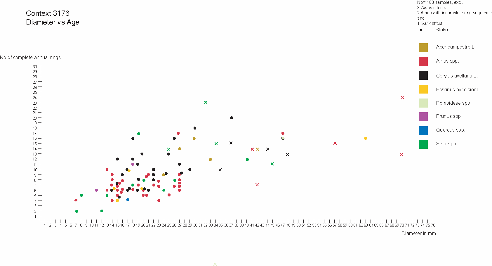
The extant woodworking technology is very limited. Stake tips have been created by hewing facets to create sharpened tips allowing them to be driven into the ground. There is no consistent pattern to the cross-sections of the tips so created – (3149) stakes include one chisel, two sub-triangular, six sub-rectangular and two multifaceted tips. The (3176) stakes include one chisel, four sub-rectangular and eight multifaceted tips – where known. Evidently it was important just to create a functioning tip rather than adhere to a set ideal cross-sectional shape. Unfortunately, the abrasive nature of the sandy burial matrix in which these stakes had been driven had eliminated any surviving tool signature marks and so comparisons cannot be made.
The single peg (ST30) is cut from radially faced Quercus spp. heartwood with both faces and both edges tapering evenly towards the tip. It is more carefully finished than any of the stakes and seems to have been intended for a different purpose.
Access to a wider range of woodworking skills is demonstrated by the find of ST21, a wooden bowl face turned from a halved Alnus spp. log (Figure 24). The two refitting fragments represent a portion of the wall and base of a plain undecorated vessel of at least 180mm diameter and at least 40mm depth. Due to the abrasive burial matrix, there are no surviving turning marks, nor is there a distinct base. While the piece is interpreted (and drawn) as described above, it is just possible that it represents part of the wall of the vessel alone from which both rim and base have been lost. Its condition precludes positive identification at this stage.
This one object shows that there were individual woodworkers with specialist skills and equipment who could be called upon at need by the community or who were supplying goods for purchase or exchange in an accessible trading partnership within the neighbourhood.
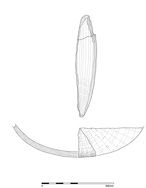
In total, fragments from four quern stones were examined, including one possible quern stone roughout. One of the quern stones comprised multiple small fragments of lava, while the remaining two quern stones and the roughout were single objects.
Ring gully fill (1073) SF1
Approximately 20% of an edge fragment of a probable lower rotary quern stone was recovered, formed from Millstone Grit — a medium-grained laminated quartz sandstone with silica cement. The quartz grains range in colour from colourless to white and pale pink, while in size the grains measure between 0.5–4mm. Identification as a rotary quern stone and the central hole are tentative, owing to the breakage. However, the curvature of the outer edge suggests that the stone was originally shaped to have a circular base. The estimated diameter of the stone is 260mm, which is small for a rotary milling tool. The fragment weighs 3449g.
The grinding surface is worn smooth from use, with a slight convex curvature to the surface as it rises from the edge of the stone towards the centre. This indicates that the stone is likely to be a lower rotary quern stone. The thickness at the edge of the stone is 84mm, while at the centre of the stone the thickness is 102mm. The rounded edge of the stone has been roughly worked and the sides are bulbous. There is a natural fault in the stone that is visible on the rounded edge. This may have contributed to the breakage of the quern stone, though a high level of force must have been involved as the stone is thick and would have been difficult to break.
Pit fill (1057), SF2
This pit contained multiple rounded fragments of grey vesicular lava measuring between 5–20mm and with a combined weight of 16g. White phenocrysts are visible in the largest fragment, suggesting a possible Mayen origin. It is highly likely that the fragments constitute the remains of a lava quern stone, though they are undiagnostic as a result of weathering and other post-depositional taphonomic factors.
Pit fill (3022), SF12
SF12 was a rubber for a saddle quern of fine-grained quartz sandstone with silica cement. The stone is roughly cigar shaped with both ends rounded. The grinding surface has been worn flat and the upper surface has been rounded. The remaining two sides differ, with one smoothed and convex and the other concave from wear. The flat, smooth grinding surface shows signs of wear that run widthways, as would be expected of a rubber stone. The stone measures 195mm in length, 75mm in width, 80mm in depth and weighs 2030g. It is possible that the rubber may have been used for purposes other than grain processing. Other uses are difficult to isolate and identify from wear traces alone.
Watering hole fill (3143), SF17
Approximately 80% of a quern stone roughout formed using Millstone Grit — a medium-grained quartz sandstone with silica cement. The roughout has an incomplete diameter of 360mm and has a thickness of 270mm (as measured from the grinding surface to the upper domed surface of the stone). Although not fully formed as a quern stone, the overall worked shape indicates that it is likely to have been intended as a lower stone for a beehive quern. The sides have been pecked in a systematic way to create a carefully worked exterior surface that reaches as far as the domed top, where the pecking does not continue. There are some chisel marks on the side that show possible rougher working at an earlier stage of the quern stone's formation, or an attempt to smooth the pecked surface (Figure 25).
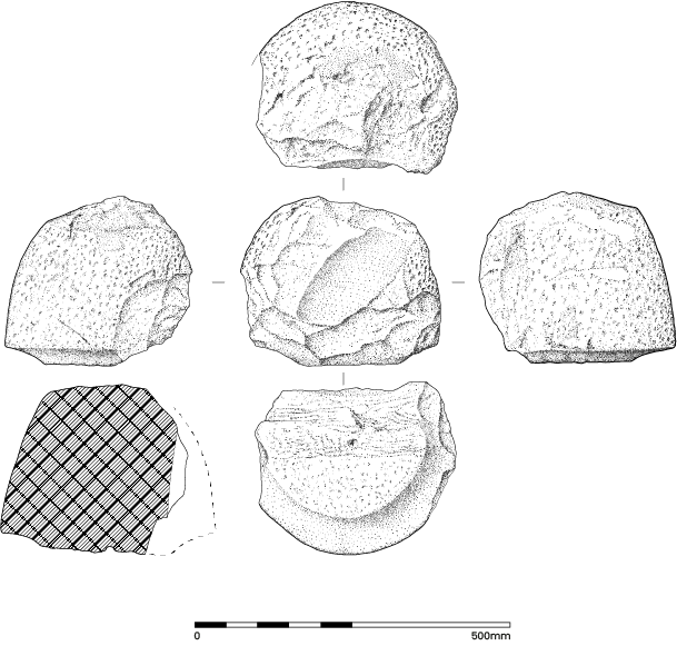
On the intended grinding surface, a small divot exists in, if the stone were complete, the central part of the stone. This measures 11mm in diameter and exists as a shallow depression approximately 4mm deep with signs of rotational wear within it. The outer circumference of the grinding surface is flattened and smoothed in a band that is a relatively consistent 40mm wide all the way around. Inside of this band; the interior part of the grinding surface is uneven and shows signs that it has been pecked.
Overall, the small quern assemblage provides an interesting glimpse into the social, technological and economic changes that took place at the site and within the wider area over a long period of time spanning the Bronze Age to the Roman period. Although occupation at the site may not have been continuous, there is a consistency implied in the evidence for domestic and small-scale grain processing at the site, though the tools used to carry out this task developed and changed in a highly visible way.
A small assemblage (total weight 0.75kg), of ironworking slags and possible non-ferrous debris was recovered from the site.
Two smithing hearth bottoms were identified. One was very small (145g) and the other (from Context 3059) was deep in relation to its diameter. Eight fragments from pit fill (3064) were classified as flowed slag, which all displayed smooth surfaces that could either be smelting slag or liquated smithing slag. There was a small quantity of cinder recovered from pit fill (3115). There were two small fragments of hearth or furnace lining, one of which had tentatively been identified on site as a possible non-ferrous crucible fragment. There was another piece of ceramic identified as crucible from cobble surface (3172), which was a base fragment of a vessel. The exterior surface was not vitrified, which is unusual, as the high temperatures required to melt most non-ferrous metals and alloys (tin and lead being the exceptions), result in the vitrification of the exterior surfaces of crucibles. There was no evidence of metal inclusions on the interior surfaces. A short programme of HH-XRF analyses was undertaken to assess whether the flowed slags derived from the smelting or smithing process, and to consider whether the hearth bottoms could be small smelting slag cakes. The crucible fragment and the fragment of hearth lining originally identified as possible crucible were also analysed.
The analysis of the flowed slag did not detect manganese, which is present in many smelting slags, especially those derived from bog ores. The analyses of both hearth bottoms displayed a trace level of manganese, but insufficiently strong to alter the classification of the slags as smithing hearth bottoms.
The exterior and interior surfaces of the hearth lining fragment submitted as a possible crucible fragment from pit fill (3059) were analysed. Trace levels of copper, zinc, tin and lead were detected on the vitrified surface and the other fractured surface; as there was no enhancement it indicates that these elements were present in the clay. Interestingly, there was a very slight enhancement of manganese on the external vitrified surface compared to the interior surface. The analyses of the large vessel fragment showed no enhancement of non-ferrous metals on the inner surface compared to the exterior surface.
The assemblage is very small (total weight 0.75kg) and was recovered from six different contexts. Distribution was quite wide, with the flowed slag on the eastern side, the hearth bottom in a ditch and the piece of hearth lining in the ring gully. The hearth bottom, the small fragment of hearth lining and the cinder all came from watering hole [3113], which was close to watering hole [3056] containing the flowed slag. The iron working slags are slightly unusual, the two hearth bottoms being very different in shape and size, and the other slags are dense and display some flowed features indicative of liquidity, probably flowed smithing slag. No hammerscale was recovered from the bulk sampling, hence the slags are in tertiary deposits, away from the smithing area.
The small assemblage is indicative of iron working, probably smithing, but smelting cannot be totally excluded as a possibility.
The following section outlines the insect remains recovered from two samples (<25> and <29>) from watering hole [3056] and three samples (<22>, <23> and <32>) from watering hole [3004].
Watering hole [3056]
The two insect faunas (Samples <25> and <29>) from watering hole [3056] are very similar in their nature. Both are dominated by insect species from two types of ecology.
Unsurprisingly, for a waterhole feature, both faunas are dominated by a range of water beetles. Species from ecological group ‘a' account for 42.3% of the total fauna in Sample <25> and 16.9% of the faunas from Sample <29>. The species recovered are all associated with slow flowing, shallow and often temporary pools of fresh water. There is also a suggestion (supported by the waterlogged plant remains) that reed sweet grass (Glyceria maxima (Hartm.) Holmb.) grew on the edges of this pool since this is the preferred food plant of the weevil Notaris acridulus (Koch 1992). Two of the ground beetles present (Pterostichus nigrita/Rhaeticus and P. anthracinus) indicate that the edges of this pool were surrounded in places by soft mud and wet vegetation (Luff 2007).
The other dominant aspect of both insect faunas are the relatively large numbers of dung beetles present, all of which are species associated with the dung of a range of grazing animals, often cattle, occupying open grassland (Jessop 1986). Similarly, the two pill beetles recovered (Hister striola and Hister cadaverinus) are often associated with dung pats, where they feed on fly larvae (Halstead 1963).
A range of other taxa recovered suggest that the waterhole was set into an area of grassland and pasture. More specifically, several of the plant-feeding species of weevil indicate individual species of grassland plants. However, there are no indicators for the presence of trees or woodland in the area.
Watering hole [3004]
The three samples from watering hole [3004] (Samples <23>, <22> and <32>) not only produced insect faunas that are similar to each other but are also similar to those recovered from watering hole [3056].
All three faunas are, again, dominated by a range of water beetles that indicate the presence of slow, still and sometimes temporary pools of fresh water.
As with watering hole [3056] many of the insects recovered are associated with the dung of grazing animals. This aspect of the fauna is dominated by a range of Scarabaeidae dung beetles such as the Dor beetle Geotrupes spp. and the dung beetles Aphodius sticticus, A. fossor, A. sphacelatus, A. prodromus, A. fimetarius and A. ater (Table 3).
| Sample number | <25> | <29> | <23> | <22> | <32> |
|---|---|---|---|---|---|
| Total number of individuals | 248 | 124 | 204 | 214 | 251 |
| Total number of taxa | 73 | 62 | 93 | 86 | 90 |
| % aquatic (a) | 42.3% | 16.9% | 29.9% | 21.5% | 20.7% |
| % water side (ws) | 2.4% | 4.0% | 3.9% | 4.7% | 3.6% |
| % deadwood and treeleaf/ terrestrial (l) | 7.3% | 1.0% | 2.2% | 1.9% | 1.6% |
| % dung and foul/ terrestrial (df) | 33.6% | 35.7% | 8.1% | 24.7% | 28.4% |
| % open ground/ terrestrial (p) | 12.4% | 20.4% | 19.3% | 15.2% | 13.2% |
In addition, other taxa in these faunas clearly suggest that grassland and pasture surrounded the waterhole. Primarily this is indicated by the recovery of a range of plant-feeding weevils. The two species of chaffer recovered, Serica brunnea and Phyllopertha horticola are also both associated with old grazed grassland and turf (Jessop 1986). There is also clear evidence for the presence of stinging nettle in the area of the waterhole since it is the exclusive food plant for Brachypterus urticae, Cidnorhynus quadrimaculatus and Apionurticarium (Koch 1992).
Conversely, there are very few indicators for the presence of trees.
Surprisingly, there are very few published insect faunas from Iron Age waterhole deposits in this part of North Yorkshire, or indeed Yorkshire in general. There is, of course, a wealth of detailed Roman and early medieval insect analysis from urban York itself resulting from the past activities of the Environmental Archaeology Unit York (for example Kenward and Hall 1995). There are also a number of faunas from prehistoric deposits in the area around Star and Seamer Carr (e.g., Osborne 1980; Kenward and Large 1997). Many insect faunas from the region are also unpublished, or remain evaluations, and this means that these five insect faunas from Wetherby Road Roundabout are of regional importance.
Outside of this region similar Iron Age waterholes are commonly found in the archaeological record and several have been investigated in terms of their insect faunas (see Smith et al. 2019). Mainly these are concentrated in the area around Heathrow (Robinson 2006; Smith 2009; 2015; Tetlow 2010) or are scattered across the Midlands (e.g., Hill 2016; Smith 2012). In essence, most of these Iron Age waterholes produce very similar insect faunas to those seen at Wetherby Road Roundabout. Smith et al. (2019) have suggested that these faunas are associated with the development of cleared, ditched and intensively farmed landscapes that develop in several parts of the UK from the late Bronze Age onwards. It would therefore seem that these deposits from this site fit an extended pattern of landscape development in this period but represent, up to this moment, one of its most northern examples.
The assessment identified very limited charred archaeobotanical assemblages for which there was little potential for further interpretation. In contrast, relatively large waterlogged archaeobotanical assemblages were recovered that demonstrated evidence for a grassland/open ground palaeoenvironment surrounding shallow, slow-flowing water consistent with the waterholes themselves. The waterlogged assemblages were consistent between all three watering holes.
As all three watering holes were assessed to have similar waterlogged assemblages, this analysis was targeted at a single deposit, Context (3068) in watering hole [3056], which provided samples for pollen and insect analyses in order to enable inter-proxy comparisons.
The recovered macrofossils are representative of shallow-water conditions surrounded by grassland or waste ground. The shallow water environment of (3068) was dominated by sweet grass, a noxious weed that is highly competitive and invasive, capable of forming very extensive stands over a metre tall and which can spread over indefinite areas of shallow water. This particular context is likely to represent a point where the shallow water had been overgrown by stands of sweetgrass. The pale persicaria and redshank both point towards wet, damp soils, the former commonly being found in waste ground and ditches, and the latter being a common spring weed growing on wet peaty soils. These both reflect the peaty, moist surroundings of the waterhole.
The remaining botanical species are broadly open grassland species that correspond with the interpretations developed for the pollen and insect analyses. Seeds were recovered from specific food plants of beetles identified in the insect analysis, notably stinging nettle and clover (Table 4).
| Context number | 3068 | 3148 |
|---|---|---|
| Sample number | 25 | 29 |
| Sample volume L | 0.5 | 0.5 |
| Botanical remains | ||
| Sweet grass (Glyceria maxima) | >400 | 3 |
| Pale persicaria (Persicaria lapathifolia) | 10 | 4 |
| Redshank (Persicaria maculosa) | 6 | 1 |
| Water smartweed (Persicaria cf. amphibia) | 1 | |
| Sedge (Carex sp.) | 4 | 1 |
| Stinging nettle (Urtica dioica) | 6 | 2 |
| Goosefoot (Chenopodium album) | 2 | |
| Blackberry (Rubus sp.) | 1 | 1 |
| Dock (Rumex sp.) | 2 | 4 |
| Buttercup (Ranunculus sp.) | 3 | 1 |
| Chickweed (Stellaria media) | 4 | |
| Lady's bedstraw (Galium aparine) | 1 |
The pollen and insect analyses provide far more nuanced illustrations of the palaeoenvironment compared with the recovered waterlogged archaeobotanical assemblages here. Although they do provide interpretations of the palaeoenvironment consistent with the other proxies, they are relatively broad in comparison.
Seven samples were submitted for provisional assessment for pollen, from two stratigraphic columns extracted from the watering holes encountered. The sedimentary deposits were found to be organic rich with limited minerogenic content. The samples were taken at regular intervals through each of the two features. Provisional assessments identified pollen preserved in relative abundance and diversity (Table 5).
| <12> | <26> | |||||||
|---|---|---|---|---|---|---|---|---|
| Depth (mbgl) | 0.60 | 0.66 | 0.72 | 0.78 | 0.14 | 0.20 | 0.26 | |
| Trees | Alnus | 79 | 35 | 39 | 31 | 104 | 121 | 82 |
| Betula | 1 | 1 | 1 | 1 | ||||
| Fagus | 1 | |||||||
| Fraxinus | 2 | |||||||
| Juglans | ||||||||
| Pinus | 1 | 1 | 1 | |||||
| Quercus | 1 | 3 | 3 | 3 | 2 | |||
| Tilia | 10 | 13 | 5 | 2 | 1 | |||
| Ulmus | 1 | |||||||
| Shrubs | Corylus-Myrica type | 55 | 37 | 32 | 39 | 6 | 3 | 5 |
| Ericaceae undiff. | 20 | 5 | 3 | 10 | 1 | 5 | 1 | |
| Hedera helix | 1 | 1 | 1 | |||||
| Ilex | ||||||||
| Salix | 1 | |||||||
| Herbs | Poaceae | 10 | 49 | 29 | 31 | 15 | 15 | 21 |
| Cyperaceae | 1 | 5 | 2 | 1 | 1 | 2 | ||
| Cereal | 1 | 1 | 1 | |||||
| Apiaceae (Umbelliferae) undif. | 1 | |||||||
| Artemisia | 1 | 1 | ||||||
| Asteraceae | 1 | 1 | 3 | 3 | 2 | |||
| Lactuceae | 11 | 10 | 4 | 9 | 1 | 13 | 10 | |
| Brassiccaceae | ||||||||
| Caryophyllaceae | 2 | 3 | 3 | 3 | 1 | 2 | ||
| Centaurea cyanus | ||||||||
| Centaurea nigra | ||||||||
| Chenopodiaceae | 2 | 3 | 3 | |||||
| Cirsium type | ||||||||
| Helianthemum | ||||||||
| Helleborous | ||||||||
| Plantago sp. | 2 | 17 | 2 | 7 | 2 | 1 | 1 | |
| Polygonum | ||||||||
| Ranunculus | 1 | 6 | 2 | 1 | ||||
| Rubiaceae | 1 | 4 | ||||||
| Rumex | 1 | 3 | 3 | |||||
| Sanguisorba | ||||||||
| Succisa | 1 | 1 | 1 | 2 | ||||
| Thalictrum | ||||||||
| Urtica | 1 | |||||||
| Spores | Diphasiastrum | |||||||
| Osmunda | ||||||||
| Polypodium | 9 | 3 | 4 | 7 | 2 | 2 | ||
| Pteridium | 3 | 9 | 10 | 8 | 5 | 3 | 12 | |
| Pteropsida (monolete) undif. | 5 | 1 | 1 | 2 | 2 | 3 | 3 | |
| Sphagnum | 1 | |||||||
| Aquatics | Myriophyllum | |||||||
| Nuphar | ||||||||
| Nymphaea | ||||||||
| Potemogeton | ||||||||
| Sparganium | ||||||||
| Typha angustifolia | 1 | |||||||
| Typha latifolia | ||||||||
| Abundance | high | high | high | high | high | high | high | |
| Diversity | high | high | high | high | high | high | high | |
Of those samples provisionally assessed, a single sequence, consisting of four pollen samples and deriving from watering hole [3056], was selected for full analysis. The samples derived from a monolith tin, extracted from the basal fill (3068), of watering hole [3056]. The sequence from which the samples were derived was recorded as monolith sample Tin <12>. The wattle lining of this waterhole was present at the same depth as the monolith tin.
In addition to pollen analysis being undertaken at the described sampling resolution, additional samples were obtained from the same depths in order to assess for the presence of diatoms (Table 6).
| Depth (mbgl) | ||||||||
|---|---|---|---|---|---|---|---|---|
| <12> | ||||||||
| Species | lifeform | pH | Trophic status | 0.6 | 0.66 | 0.72 | 0.78 | |
| Tychoplanktonic | Pseudostaurosira brevistraata | F Tycho | D | C | 7 | |||
| Benthic | Navicula radiosa | Epipelic | C | C | ||||
| Neidium iridis | Epipelic | C | U | 1 | 1 | |||
| Pinnularia cf. rupestris | Epipelic | B | A | 4 | 11 | 11 | 2 | |
| Staureoneis gracilis | Epipelic | C | A | 3 | 9 | 1 | ||
| Epithemia adnata | Epiphytic | E | B | 1 | ||||
| Eunotia diodon | Epiphytic | B | C | 1 | ||||
| Eunotia monodon | Epiphytic | B | C | 2 | 1 | 15 | 25 | |
| Eunotia pectinalis var. undulata | Epiphytic | B | C | 1 | ||||
| Gomphonema gracile | Epiphytic | C | C | 2 | ||||
| Hantzschia amphioxys | Aerophilous | C | A | 5 | 64 | 9 | 10 | |
| Pinnularia borealis | Aerophilous | B | A | 6 | 16 | 11 | 4 | |
| Pinnularia microstauron | Aerophilous | B | C | 1 | ||||
The watering hole <12> pollen assemblage provides an insight into the vegetation dynamics that prevailed at the locale, prior to the feature being abandoned and becoming infilled. Diatoms were unfortunately less well preserved but assist in interpretations, guided primarily by the pollen assemblages. The pollen signal is interpreted as suggesting a landscape that was initially somewhat open, but with pockets of established woodland and/or scrub in relative proximity to the sample site, for much of the duration of watering hole use. The uppermost sample then records a shift to an apparent increase in trees and shrubs, suggesting a phase of woodland and heath regeneration prior to infilling. The diatoms contain only benthic and a brief impulse of tychoplanktonic species, and so the water body was likely very shallow for the duration of sediment accumulation. Indeed, the dominant diatoms, Hantzschia amphioxys and Pinnularia borealis, are classified as aerophilous and hence likely thrived on the margins of the watering hole where the water level fluctuated. The most common diatoms are eutrophic and hence the water body and/or water flowing into the watering hole was likely nutrient rich. Most diatoms are also acidophilous to circumneutral, suggesting a slightly acidic to neutral pH, likely a reflection of the local Sherwood Sandstone bedrock geology. In the uppermost sample, diatoms are very limited in number and hence cannot assist subsequent interpretations. However, the pollen signal appears to contradict the plant macrofossil and beetle assessments, derived from bulk samples, both of which indidcate an open landscape with very limited evidence of woodland (Krawiec 2023).
That said, there are some strong similarities when comparing these results to the pollen and diatoms encountered. The beetle assemblage reinforces the interpretation of the pollen record, alluding to pastoral farming, and also only contains a relatively limited faunal assemblage associated with open water. The abundance of dung beetles within the watering hole may also indicate that the farming practices were a source of nutrients that made the watering hole suitable for eutrophic diatoms, with nutrients derived from dung/manure etc. Similarly, many of the subordinate plant remains encountered were also present within the pollen profile (e.g. sheep's sorrel, wild grasses, cinquefoils, orache, sow thistles, water pepper, blink, and duckweeds) and when viewed as a whole, the vast majority imply damp meadows and/or seasonal flooding. Furthermore, when combined, both plant macrofossils and beetles are evidence of damp conditions with possible seasonal flooding, and the relative abundance of aerophilous diatoms would further reinforce such an interpretation. However, while the macrofossil results therefore suggest that any patches of woodland were not in the immediate vicinity of the watering hole, the pollen profile suggests that some woodland was relatively close. It is suggested that a small and relatively open woodland, typified by lime, alder and hazel, and/or hazel hedgerows, was proximal to the settlement. These patches may have been bisected by one of the springs that were identified by hydrological engineers during the groundworks. This spring may in turn have fed and maintained the watering hole, introducing the evidence for an arboreal influence that was not apparent in the macrofossil analyses.
Archaeological study of the rural hinterland west of York has been quite sparse in terms of physical investigation, consequently limiting the scope for analysis because of the few sites excavated in this area. The analysis presented here seeks to take steps towards addressing this deficiency. Although the dataset presented by the Wetherby Road Roundabout works is small in scale, its strength lies in the quantity and quality of preserved organic remains. Examination of the site in reference to other sites in the locality, including the synthesis by Steve Roskams and Cath Neal on the excavations carried out at Heslington East (Roskams and Neal 2020) and the recent excavations conducted by York Archaeology at the former Civil Service sports club and playing fields on Boroughbridge Road (Howlett in prep), support a picture of occupation, land use and exploitation of the natural environment in the vicinity of the Wetherby Road Roundabout site.
The greatest impact on the character of human activity at the site appears to have been ready access to water from a spring. Evidence from the site demonstrates exploitation of this natural feature was at its peak in the Late Iron Age/Romano-British period. However, people may well have been attracted to the spring from a much earlier point in prehistory.
Evidence for the earliest activity at the site is provided by a small assemblage of flint artefacts, dating to the Neolithic or Early Bronze Age. All three items were found residually in deposits of a later date. However, they are perhaps most useful in what they convey about the type of activities for which they would have been used, the processing of food or hides, and what their source of origin suggests regarding cultural processes around trade and exchange. In this regard the Wetherby Road Roundabout assemblage is typical for York and the surrounding area. The Yorkshire Wolds were found to be the common source of Neolithic and Bronze Age flint at Boroughbridge Road and Heslington East (Loffman in prep; Roskams and Neal 2020, 23), and the Holderness Till of East Yorkshire and Durham or the red chalk north of Flamborough Head in that region are thought to have been the most likely sources for the Wetherby Road Roundabout material.
The earliest dateable features on the site were a curvilinear gully and a large pit located towards the southern end of Area 3. Charcoal, heat-fractured stones and a rubber for a saddle quern were all found in the basal fills of the pit. Radiocarbon analysis of the charcoal dates it to the cusp of the Early to Middle Bronze Age and all of this material is indicative of occupation and food processing in the vicinity. In addition, the local sandy soils would have been fertile and suitable for arable use, and while it is possible that the quern rubber may have been used for purposes other than grain processing, its presence indicates a significant probability that cereals were being processed and consumed at the site, while more broadly hinting at the agrarian character of activity at the site by this time.
Land use at Wetherby Road Roundabout compares favourably with evidence from Heslington East, where exploitation of the landscape had become increasingly regular and sedentary, involved both keeping livestock and, by the Late Bronze Age, farming of cereal crops (Roskams and Neal 2020, xi, 42 and 46).
Aerial photography has identified likely prehistoric landscape division around Knapton and Poppleton (O'Brien and Bruce 2015), north of Wetherby Road Roundabout, while geophysical survey has identified a landscape of intense, prolonged agricultural use at York Community Woodland, a 40-hectare area of land immediately north-west of the Wetherby Road Roundabout site (Wilkinson and Clements 2021, 2). By the end of the Iron Age, field systems had become well established to the south-east of York, at Heslington East (Roskams and Neal 2020), while a network of rectilinear ditched enclosures uncovered at Boroughbridge Road demonstrates the presence of comparable land management only 2km north of Wetherby Road Roundabout (Howlett in prep).
Evidence for enclosure at the site was somewhat fragmentary, the result of the modern road network partitioning the site and its narrow, linear aspect. However, land division appears to have been largely laid out in a rectilinear pattern with a double-ditched enclosure north and west of a group of watering holes in Area 3 and a second ditched enclosure to their east. The presence of sandwort, elder and ash suggests that hedgerows may also have been in place (Krawiec et al. 2020, 79).
By the Late Iron Age, a mixed farming economy had been established. The recovery of rotary querns from several features show that grain processing continued, although evidence for cereal production nearby is somewhat lacking in the paleoenvironmental record. The type of features present at the site and the remains preserved within them demonstrate that controlling livestock movement and providing them with access to water had come to dominate the mode of landscape exploitation.
During this period the spring exploited by the watering holes served as a focal point of agricultural activity and there are hints that settlement lay nearby. The paleoenvironmental assemblage implies that the surrounding area was grazed grassland or rough pasture, perhaps subdivided with low shrubby hedges. This picture is not, however, entirely static, as an increase in pollen deriving from trees and shrubs was present in the upper part of the central watering hole, suggesting a phase of woodland and heath regeneration as this feature silted up. This signal was not detected in any of the later neighbouring watering holes, so by implication woodland and heath appear to have died back before silting had occurred in those features. The insect assemblage recorded in all of the watering holes comprised large numbers of dung (Aphodius) and blue ‘dor' beetles (Geotrupes spp.) indicating large herbivores were regularly accessing those features, and is further evidenced by the large quantity of elder and nettle represented, which would have benefited from nitrogen-rich soils augmented by the presence of livestock.
Sustained exploitation of the watering holes from the Late Iron Age is indicated by radiocarbon dates from wood and charcoal and the recovery of prehistoric handmade tradition pottery. Use of the southern watering hole continued up to the 2nd century CE; it was cleared out and had a cobble layer installed to improve access and make it more durable. A north-east/south-west aligned ditch ran close to the north side of that feature and cut across the northern group of watering holes, which were redundant by that time, and indicates a focus more on funnelling livestock towards the re-engineered watering hole rather than maintaining established field boundaries.
South-east of the watering hole was a 15.5m diameter ring-ditch enclosure with a 3.2m wide east facing entrance. The pastoral character of activity at the site suggests likely use as an animal stockade. However, livestock management may not have been its sole function. Four pits were found close to the entrance and the absence of any other features in the enclosure indicates that grouping of these features is unlikely to have been coincidental. The implication here is that if the enclosure had ever been used to corral livestock, that practice would very likely have ceased by the time the pits had been dug, as even after backfilling the softer ground left by the pits would have created a risk of injury to livestock traversing that area.
Water levels appear to have been neither deep nor constant, judging by the absence of aquatics from the pollen data. This likely influenced the level of maintenance required to preserve viable and convenient access to water. The absence of duckweed from the environmental assemblage, for example, perhaps reflects its removal in an attempt to prevent the water from stagnating, while the general lack of waste in the lower deposits suggests that the area was kept clean. Wattle linings were installed in two of the five watering holes and would have offered some mitigation against erosion of the feature sides. Nonetheless these could not prevent long-term silting, and re-cutting clearly became a necessity with (as highlighted above), significant efforts being made in the latest watering hole to improve access for livestock by means of hard standing in the form of a cobble layer.
Trade in livestock raised at the site would have been a key economic output for the local community. Insight into economic links is shown by a range of materials and artefacts found at the site. Some materials were very likely locally sourced by the community themselves, such as the wood used for wattle linings and perhaps the turned wooden bowl. Specialist products originating outside of the neighbourhood include a small selection of locally produced Roman oxidised wares, while regional imports are represented by Millstone Grit rotary querns, the raw material most likely sourced from either the Pennines or Peak District. Wider trade networks are indicated by fragments of lava quern from Germany and a sherd of Central Gaulish samian ware. The settlement at York probably served as the hub for trade in these commodities during the latter part of settlement at the site.
Environmental evidence gives some indication that woodland occupied by species including alder, lime, and hazel was present in the vicinity. Wattle linings in the watering holes were sufficiently well preserved to establish that a range of species were being utilised for construction. Nonetheless, a regular cycle of coppicing or pollarding does not appear to have been a requirement for the collection of this material.
Some material types present at the site demonstrate that specialist skills and equipment either existed within the local community, or were available to it through purchase, exchange or trading partnerships. The turned wooden bowl and the rotary quern fragments (including a beehive lower quern stone roughout) are examples of this. Work on the unfinished quern was well advanced when failure due to a natural fissure caused sufficient damage for it to be abandoned. The implication is that finishing work was carried out locally. Recovery of a small quantity of flowed slag, a hearth bottom and a piece of hearth lining from Late Iron Age/Romano-British features shows that iron working, probably smithing but possibly smelting, was being conducted at least on a limited scale at the site. The presence of heat-fractured cobbles, burnt bone, charcoal, part of a hearth lining, pottery sherds and part of a Millstone Grit lower rotary quern in the southern half of the ring-ditch may be taken as indicative of some kind of processing or small-scale industrial activity, if not the presence of settlement close by.
A range of striking similarities are apparent with how Late Iron Age/Romano-British agricultural activities at Heslington East and Wetherby Road Roundabout exploited the available landscape resources during the Late Iron Age/Romano-British transitional period. A mixed farming economy is evident, with a significant weighting towards pastoral activity focused on watering and control of livestock hinging on the presence of reliable spring water. Stabilising the sides of watering holes with wattle linings, which was at times augmented with cobbled hard standing, ensured long-term access for livestock. When maintenance became a necessity, re-cutting was undertaken or a new watering hole was opened in the vicinity. An element of seasonality to the availability of water is suggested by the pattern of silting and the plant fossil remains present in some of the Wetherby Road Roundabout watering holes. The positioning of boundaries in relation to wells/watering holes would have enabled control of livestock movement to and from those features.
Dating evidence demonstrates a continuity of pastoral activity from the Late Iron Age into the 2nd century at both sites, with the establishment of the fortress and settlement at York having little apparent influence. Agricultural practice and how the landscape was managed did not, however, remain static throughout the Roman period. At Heslington East the laying out of a new road along the spring line appears to have been the catalyst for a substantial shift in the organisation of landholding into the later Roman period. The 2nd century was also when the last watering hole at Wetherby Road Roundabout finally silted-up, implying that the water source had by then lost its importance. Given the small area of this site, abandonment of the spring cannot be seen as conclusive evidence of a comparable transition in landscape exploitation, particularly as the area investigated at Heslington East was substantially larger, but it does at least offer an intriguing parallel hinting at a local reorganisation of agricultural practices in York's hinterland.
York Archaeology thanks Claire MacRae, Gary Frost and the team at CYC, Riley's and Prestige for their cooperation during the course of the works. Illustrations by B. Price unless otherwise stated. Thanks are extended to Lesley Collett, David G. Griffiths and Charlotte Britton; Archaeology.biz, Dr Tom Hill; Paleoenvironmental Research and Consultancy Services, Dr Gerry McDonnell and Nicola Rogers, with special thanks to David Dodwell for the aerial photography and R. Duffield for the pottery illustrations.
The following York Archaeology staff contributed to the project: Steve Allen, Kate Allenby, Lindsay Banfield, Francesca Birtles, Tom Coates, Lilly Graham-Stewart, Sam Grimmer, Claire Jackson-Slater, Anne Jenner, Arran Johnson, George Loffman, Steve Malone, Kris Poole, Briannie Price, Ben Reeves, Augustus Shaw, Katie Smith and Rebecca Wilson.
Internet Archaeology is an open access journal based in the Department of Archaeology, University of York. Except where otherwise noted, content from this work may be used under the terms of the Creative Commons Attribution 3.0 (CC BY) Unported licence, which permits unrestricted use, distribution, and reproduction in any medium, provided that attribution to the author(s), the title of the work, the Internet Archaeology journal and the relevant URL/DOI are given.
Terms and Conditions | Legal Statements | Privacy Policy | Cookies Policy | Citing Internet Archaeology
Internet Archaeology content is preserved for the long term with the Archaeology Data Service (ROR). Help sustain and support open access publication by donating to our Open Access Archaeology Fund.
 Home
Home