Cite this as: McKeague, P. 2026 'The Maritime Record in Scotland from Recording to Presentation', Internet Archaeology 72. https://doi.org/10.11141/ia.72.7
With approximately 18,743 km of coastline along the high-water line, 462,315 km² of sea and over 900 islands, Scotland has a rich and diverse maritime heritage, if not the concentrations of wreck sites seen elsewhere in UK waters (McKeague 2025, 29). Information about these wrecks is recorded in the National Record of the Historic Environment (NRHE) for Scotland, maintained by Historic Environment Scotland (HES) and published on trove.scot. The NRHE comprises an integrated record of over 320,000 site and wreck records, the activities that inform those records, and over 1.5 million associated archival records about the archaeological, maritime and built heritage of Scotland. The remit of the maritime record is informed by, though not restricted to, Scottish inshore waters (out to 12 nautical miles) and offshore waters (12 to 200 nautical miles). HES is also responsible for formally protecting Scotland's heritage through Designations, including Scheduled Monuments and Historic Marine Protected Areas. Information in the NRHE supports decision making, research and casework within HES, and is an essential consideration in environment impact assessments and planning applications.
The maritime component of the NRHE was developed in the mid-1990s following recommendations in the Joint Nautical Archaeology Policy Committee's code of practice for seabed developers (Joint Nautical Archaeology Policy Committee 1995) for commercial operators to seek advice on the possible archaeological potential of proposed developments at the earliest opportunity (McKeague 2025). Wreck locations and other unidentified navigational hazards (obstructions) were primarily sourced from the UK Hydrographic Office Wreck database. Publications by Larn and Larn (1998) and Whittaker (1998) provided comprehensive lists of 'casualties': reported losses. As of 27 October 2025, there are 4644 wrecks and 1386 other obstructions, as well as 23,231 casualties and five find spots, but no submerged palaeo-landscapes. The focus was and is very much on recording location, but there is much more potential for developing content from the Activities (Events) and Archives that inform the record.
The origins of the NRHE lie in a card index compiled by the Ordnance Survey (OS), Britain's national mapping agency, to inform the selection of archaeological sites for publication on OS maps. Following computerisation in the early 1990s, the NRHE was first published online in 1998 through Canmore (Nimmo and McKeague 2018), before migrating to trove.scot in June 2025. Emphasis on location continues through to the contemporary record but the supporting information is now managed through Events and Archive tables (Figure 1). Place (Monument), Event and Archive records within trove.scot are uniquely identified through locally issued URLs composed of a root URL and internal database table index ID. The Place and Event records form a 'national inventory' (Figure 1 - D) within the NRHE. The associated archives preserve the evidence from individual Event and help inform the understanding of Place records. In return Place records act as finding aids to associated Archival collections.
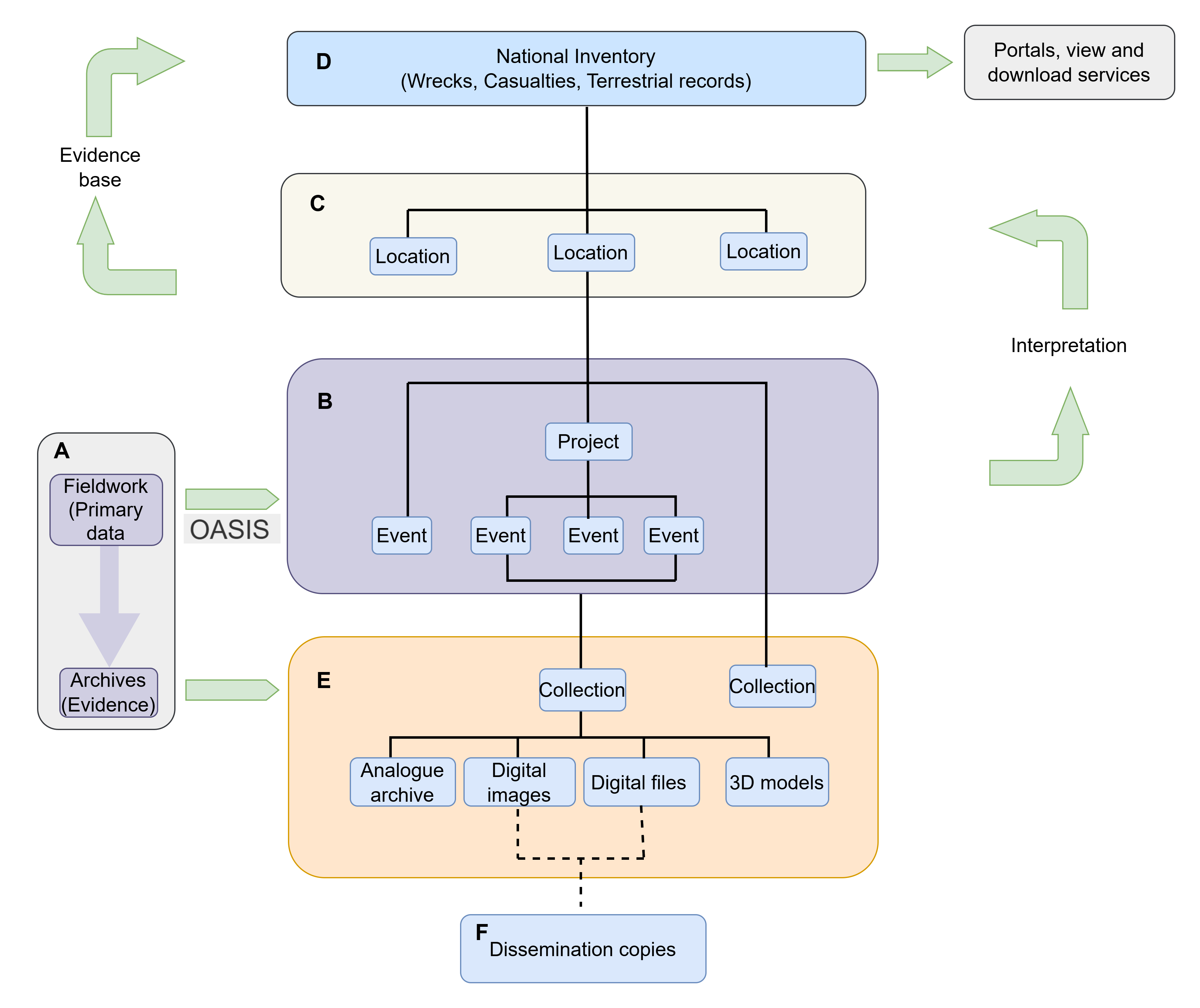
The key components of the NRHE are:
Archives (Figure 1 - E) are those project archives formally deposited and accessioned with HES Archives. Archive material may include both analogue (plans and drawings, manuscripts, photographs and slides) and digital (images, videos, digital documents, databases, spreadsheets, computer-aided design (CAD) and geographical information system (GIS) files, etc.). Dissemination copies (Figure 1 - F) of some of the digital formats are available for download through trove.scot. Archive items may either be catalogued individually or batch catalogued under a general collection (for older entries) or as part of a specific project archive. The following URL structure is used to index archive records <https://www.trove.scot/archive/UID>, for instance the Group level entry for Colin and Paula Martin's Duart Point archive is https://www.trove.scot/archive/1328495 while https://www.trove.scot/image/1328790 describes a specific catalogue entry within that project archive.
There is also capacity to store ORCID (Open Researcher and Contributor) IDs and ROR (Research Organisation Registry) IDs against people and organisations associated with Events or Archive material.
These authority files are widely used across heritage organisations in Scotland. For instance, they are embedded in OASIS, a standards-driven online reporting form that allows researchers to report the results of their fieldwork, including sharing copies of project reports, with the relevant Historic Environment Record (HER) and adding events to the NRHE. It references the same thesauri and other controlled vocabularies to ensure consistency in reporting and sharing information across the workflow.
The value of the information in the NRHE goes beyond individual summaries of fieldwork and project archives, and is realised through the relationship between individual Events and archives that inform the understanding and interpretation of a wreck (or site).
In providing a comprehensive, publicly accessible resource about Scotland's historic environment, information in the NRHE supports a range of activities, including informing planning and management decisions, and supporting research and public engagement. As such these resources are often quoted in both printed and digital publications as well as websites, and bookmarked by users on their own browsers.
For instance, The Perth and Kinross Archaeological Research Framework (SCARF 2022) includes a case study for the Carpow Logboat (Woolmer-White and Strachan 2022); a Bronze Age logboat discovered on the intertidal mudflats of the Tay Estuary in eastern Scotland in 2001. Published in 2022, the case study includes a link to the relevant record from the NRHE, then published on Canmore with the URL https://canmore.org.uk/site/196138/carpow-bank. Moving from the internally hosted Canmore website to externally hosted trove.scot in June 2025, required new URLs following the infrastructural change and rebranding. The URL for the Carpow Logboat was updated to https://www.trove.scot/place/196138. Acknowledging the extensive use of existing Canmore URLs outside of the website, locally managed redirects have been put in place to ensure that, in the short term, users can seamlessly reach the relevant resource on trove.scot. Going forward Persistent URLs are required for each component in the NRHE.
Locally managed URLs are prone to alteration through rebranding or infrastructural change, and redirects require long-term maintenance. Use of Persistent Identifiers, such as DOIs (Digital Object Identifier), offers long term stability, ensuring web content remains findable, accessible and unique over time, even with infrastructural and branding changes. They provide a permanent citable link for publications, making it easier to track citations and measure the value of content.
NRHE locational data is also published on PastMap, a map browser offering location-based searches alongside HES designation datasets. Links from individual records on PastMap take the user to the full record on trove.scot.
Spatial datasets from the NRHE and designated datasets are also published as view (web map services) and download (web feature services) under an Open Government Licence, with Ordnance Survey Presumption to Publish where relevant through spatialdata.gov.scot, harvested to data.gov.uk and, for marine-related datasets, on the MEDIN portal. Both the Historic Environment Scotland Download Portal and trove.scot also provide access to these services and downloads through more user-friendly, human-readable web pages. Scottish Government's National Marine Planning Interactive and SEWeb portals consume these services to present historic environment data alongside other environmental and societal data. As open datasets, HES web services may also be used directly alongside other data within remote GIS applications, enabling users to work more efficiently.
Over the last decade, HES has developed several partnerships with the wider marine community. These highlight both the depth of information about our maritime heritage beyond wreck location and the importance of that record beyond the historic environment and how it contributes to the wider marine ecosystem.
Between 2022 and 2024, HES was part of a consortium of public bodies, universities and other researchers in 'Unpath'd Waters: Marine and Maritime Collections in the UK', funded through the United Kingdom Government's lead research body UK Research and Innovation (UKRI)'s Towards a National Collection (TaNC) project programme. Unpath'd Waters demonstrated the considerable potential for improving engagement with maritime heritage through digital solutions (Sloane and Unpath'd Waters Consortium 2025). The project recommendations set out a route forward for developing a UK digital collection, including enhancing the national records (Sloane and Unpath'd Waters Consortium 2025, section 17). A key deliverable of the project was the Unpath'd Waters Portal, based on the infrastructure of the European Ariadne Portal. For the first time users can search resources from the national heritage agencies across the UK and the Isle of Man and the Archaeology Data Service (ADS) seamlessly through the Unpath'd Waters Portal (Richards et al. 2025).
HES is a member of the Marine Environment Data Information Network (MEDIN). MEDIN is a partnership of UK organisations committed to improving access to and stewardship of UK marine data. There are seven accredited Data Archive Centres (DACs), including bathymetry, geology and geophysics, flora fauna, and habitat and fisheries. Along with the ADS and The Royal Commission on Ancient and Historical Monuments of Wales (RCAHMW), HES forms the Historic Environment DAC. In encouraging the deposition of project data with the relevant DAC, MEDIN promotes the use of data standards and endorses the FAIR (Findable, Accessible, Interoperable, and Reusable) data principles for resource discovery and reuse.
HES is also a member of the UK Centre for Seabed Mapping, a collaborative seabed mapping community that coordinates the collection, management and accessibility of publicly funded data. Large area remote-sensing surveys undertaken as part of environmental impact assessments in advance of commercial developments have considerable potential for identifying wreck sites and evidence of submerged landscapes. The Historic England Marine Data Exchange Heritage Accelerator (MDEHA) project aims to realise the potential of heritage information from such surveys to enhance their National Marine Heritage Record (NMHR).
There is also a growing interest in potentially polluting wrecks through Project Tangaroa, with the need to not only record cargo but also method of propulsion. With so many partnership projects and calls on our data, there is a clear need to ensure that HES maritime data is structured so that it is easily discoverable and reusable.
One of the strengths of the NRHE is the relationship between the Inventory and the Archive. Information about the monuments in the inventory act as finding aids to related material in the archives. There is considerable potential to improve public engagement and meet the needs of the wider marine industry through better structuring and explanation of how the record developed, through linking to related online resources, and improving access to digital data.
When the maritime record was first created, the structure of the database addressed the immediate need to record reported wreck locations. As a result, a known wreck site or reported loss could be recorded in more than one location depending on available information sources. The tendency to identify wreck sites with possible losses in the vicinity adds further potential confusion to the record.
For instance, the location of the Imperial German Navy submarine U12, sunk off the east coast of Scotland in 1915, has been recorded in different locations based on anomalies detected on the seabed, or from documentary sources, at different times (Figure 2).
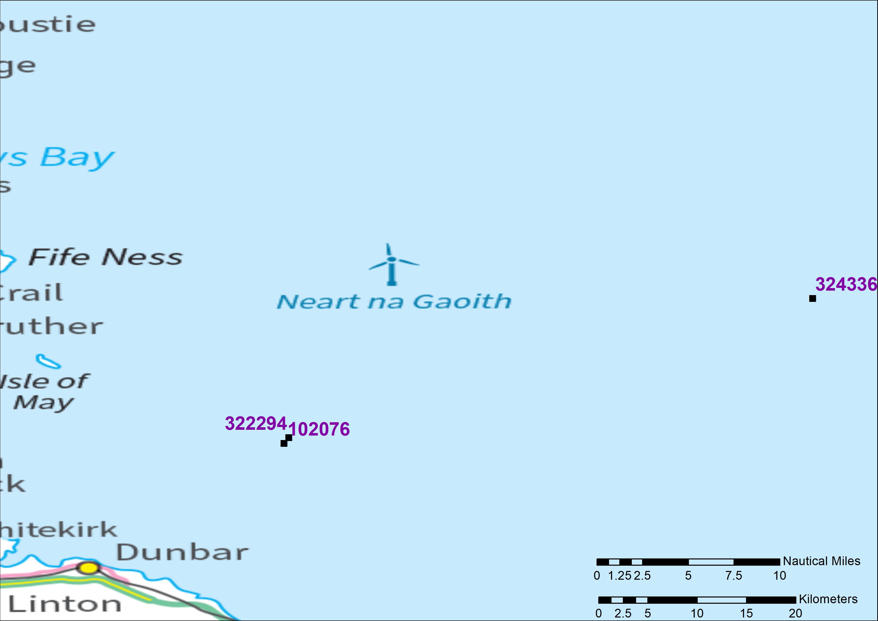
Each location has been assigned a separate wreck record, even though they all purport to relate to the same vessel. The current location (NRHE ID 324336), identified through a UKHO (UK Hydrographic Office) multi-beam sonar survey, lies almost 18 nautical miles (32 km) distant from the previously reported locations (NRHE IDs 322294 and 102076) known from documentary sources. NRHE ID 322294 is recorded as a reported sinking noting that the position quality is unreliable. That location and vessel identification, as the U12, is probably drawn from the sources Whittaker consulted in compiling Off Scotland (1998) and recorded separately (NRHE ID 102076). Both records should really be managed as separate Events for that general location and linked to the current wreck record as part of the evidence trail (NRHE ID 324336). As the information is sourced from archival reports, there may not even be a physical wreck at that general location but, as the position of a reported loss, that location still needs to be recorded. The tendency to name wreck sites from documentary sources can be unhelpful. Research in the Irish Sea off the coast of Wales has shown that a significant proportion of known wreck sites has been incorrectly identified, and that confidence in identification could be significantly enhanced through combining survey with archival research (Roberts and Quinn 2025, 86; McCartney 2022). For the U12, understanding that only the record for the current location (NRHE ID 324336) came from a confirmed contact through a remote-sensing survey adds confidence to that location over reported documentary losses.
The introduction of an Events module within the NRHE in the 2000s provided the flexibility to formally manage the relationship between the Events or Activities that inform our understanding of the record. In the example, each of the three reported locations should be recorded as Events related to the wreck of the U12, as the vessel is named in the supporting documentation.
Knowing whether a location was reported from documentary or secondary sources, or identified from a remote-sensing survey or diving inspection, provides confidence in location. That information also needs to be recorded consistently for each Event. Information about reported losses from secondary sources can be vague. For instance, Larn and Larn (1998), quoting Marriott (1987), reported the loss of the Dutch East Indiaman Zeepaard (NRHE ID 242518) as 'described in the DAS as being wrecked of the Shetland Islands, and as far as is known has never been located. (RGP-166 Vol 11, p 150–1)'. Research on a wreck site in Broadhaven Bay, Co Mayo, Ireland, identified the vessel as the Zeepaard (Brady 2017; Shipwreck Inventory of Ireland database W06923; https://mass.cultureelerfgoed.nl/zeepaard). Even though the location of the wreck has been confirmed as in Irish waters, as the Zeepaard had previously been reported as lost 'off Shetland' the record has been retained in the NRHE to aid researchers. The record has been updated to include a brief summary (NRHE Event ID 1047649) informed by the Irish record and a link to the related record on the Rijksdienst voor het Cultureel Erfgoed MaSS: Stepping Stones of Maritime History Portal.
Much of the NRHE maritime record is a record of loss, with very limited information about the vessel construction, history or crew. In any case much of this information has been thoroughly researched and published on dedicated websites. For instance, the Scottish shipwrecks website provides access to a wealth of information from the research of Ian Crawford and Peter Moir. UBoat.net provides a comprehensive record including images of all German U-boats from both World Wars, details about their commanding officers and operations, including Allied ships attacked, and a similar section detailing the Allied response to the U-boat threat. The Scapa Flow Historic Site website provides an authoritative source for the maritime archaeology and history of Scapa Flow, including links to project reports. Both Scottish shipwrecks and UBoat.net have additional information about the U12 (Scottish shipwrecks U12 and Uboat.net U12) beyond the scope of the NRHE. Managing cross-references to related websites provides a short-term solution to adding value to the maritime record — albeit at the risk of link rot. Managing links to related resources can also 'virtually' reconnect the descriptive accounts and related archives in the NRHE with relevant collections in the National Museums Scotland (McKeague 2025, 30).
Compared to the terrestrial record, which is rich in descriptive text from fieldwork and research, supported by an associated archive, paper records including drawings, photographs, etc., maritime records are often sparse in content and associated archive. Exceptions include excavated wrecks such as the Duart Point wreck (NRHE ID 80637), identified as The Swan, a 17th-century warship lost off the Sound of Mull, excavated between 1992 and 2003 (Martin 2017). The record for The Swan includes summary accounts reported through Discovery and Excavation in Scotland at the end of each field season, and a full catalogue of associated archives, including both analogue (plans, photographs and physical reports/manuscripts)) and digital (images, videos and reports). The digital images, reports and videos may be browsed online and, in some cases, downloaded for personal or educational use. Videos may document the condition of the wreck, some of the discoveries on the seabed or the divers in action. Dissemination copies of the videos are stored on Vimeo.com and embedded in the relevant page on trove.scot (NRHE Archive ID 1471524; Figure 3). For longer videos, dissemination copies may be trimmed for display purposes.
Routine diving inspections are carried out to assess a known wreck or archaeological site, often for monitoring purposes or as a report on the initial discovery of a wreck site. A report on the condition of the wreck may be accompanied by video footage highlighting aspects of the inspection, which again may add value to the record as a snapshot of the conditions of the wreck at the time of inspection. For instance, videos were made of selected vessels during the Scapa Flow Underwater Salvage Sites Survey in 2018 (SMS Derfflinger, NRHE ID 102282, videos NRHE Archive ID 283074, NRHE Archive ID 2839410). As well as a valuable record of the conditions at time of visit, these video clips can help public engagement with difficult to access wrecks.
Created from multi-image photogrammetry, dive trails provide virtual access to wreck sites. They allow the creators to develop engaging stories about the history, loss and rediscovery of wrecks, and enable viewers to explore an otherwise difficult to access wreck. The Nautical Archaeological Society produced a Dive Trail hosted on a standalone website (CloudTourTV) for The Drottningen af Swerige (Queen of Sweden) (NRHE ID 206700), a Swedish East Indiaman wrecked off Lerwick Harbour, Shetland Islands, in 1745. As with the videos, embedding the model within trove.scot would add value to the NRHE record, providing users with virtual access to the wreck site. As a record of the condition of the wreck at the time of survey, the images (or a selection of those images) taken to build the dive trail should also be deposited with HES Archives.
Most of the confirmed wreck locations in the NRHE are known from marine geophysical surveys undertaken by the UKHO and more recently from environmental assessments as part of commercial offshore developments. Data from seabed and sub-seabed geological and geophysical data covering the UK Continental Shelf (UKCS) is archived with the British Geological Survey (BGS), the accredited MEDIN Data Archive Centre. The British Geological Survey GeoIndex (Offshore) provides a searchable web map, web services and an API to these resources and through the MEDIN Portal. The GeoIndex (Offshore) may hold primary date from archaeological remote-sensing surveys. The data from a 2006 survey (NRHE ID 884282) by Wessex Archaeology on the San Juan De Sicilia (NRHE ID 22320), a Spanish Armada Galleon lost in Tobermory Bay, Mull, was deposited with the British Geological Survey, with diver tracking logs deposited with HES Archives (NRHE Archive ID 1266294).
For archaeologists, marine geophysical surveys provide important insights into the location, extent and condition of known wrecks at a given point in time. Survey results are an important tool when considering wrecks for protection and/or long-term monitoring of their condition. The potential of marine geophysics for archaeological evaluation of the seabed through a range of techniques is set out by Firth (2011).
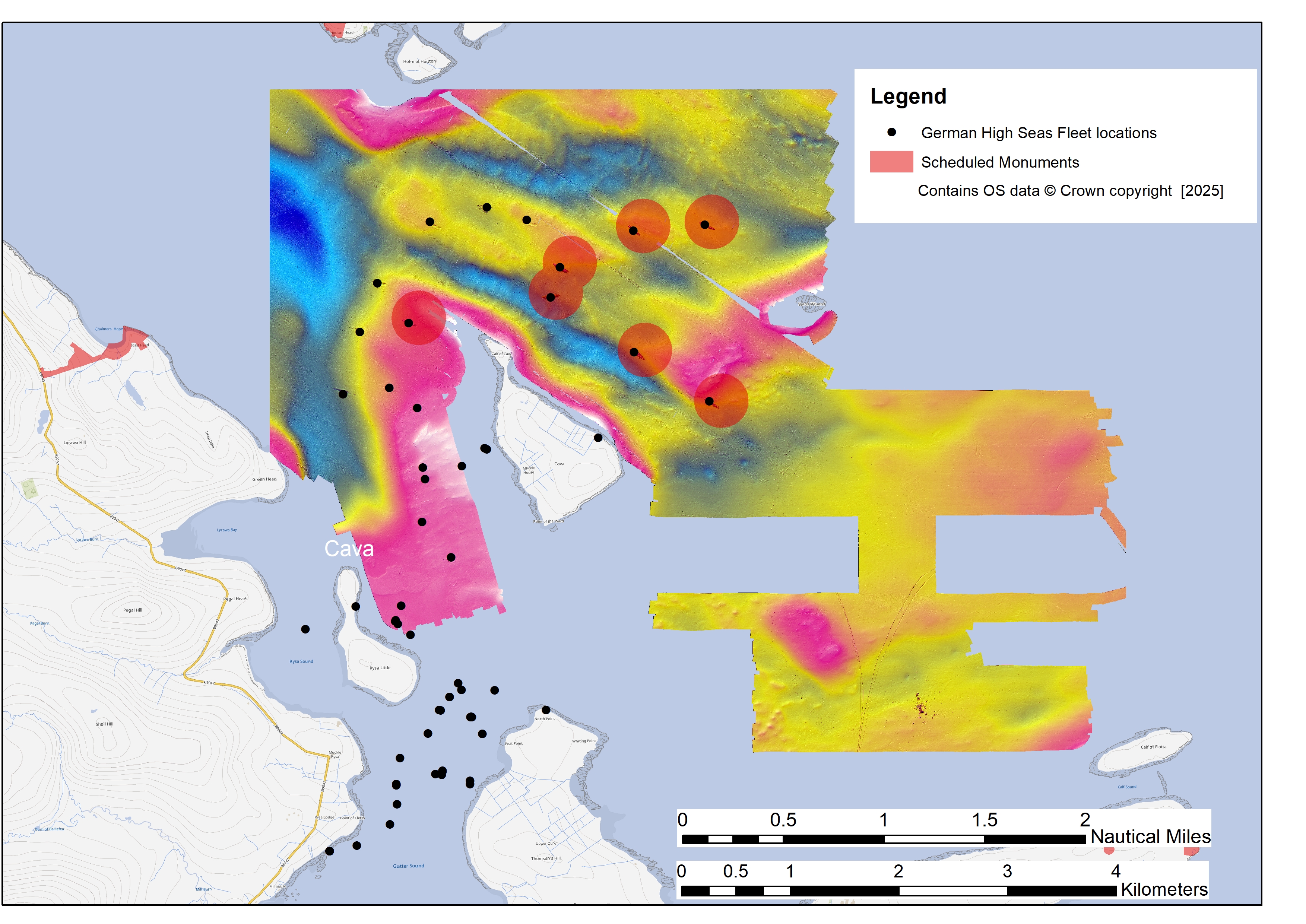
Since 2001, a series of remote-sensing surveys have been undertaken to support the designation and monitoring of the remains of the German Imperial Navy's High Seas Fleet, scuttled in Scapa Flow, Orkney, in 1919. Surveys include the ScapaMap Project (2001 to 2006) (Forbes 2002, 2006; Oxley 2002), The Scapa Flow 2013 Marine Archaeology Project (Christie et al. 2014), Scapa Flow Underwater Salvage Sites Survey Phases 1 and 2 (Henry et al. 2018; Heath and Thomson 2019). Information has been added to the NRHE for wrecks surveyed, but reviewing the catalogued archive for these surveys highlights the inconsistent approach to archiving the primary data compared with The European Archaeological Council (EAC) guidelines for the use of geophysics in archaeology (Schmidt et al. 2015, 18–19). Project archives typically include a digital copy of the project report and copies of raster images used as illustrations, and sometimes the survey extents as a vector file. Both primary survey data and vector outputs are invariably noticeable by their absence in HES Archives. The primary data from the ScapaMap project is available from the Scapaflowwrecks website, albeit it in proprietary Fledermaus format. Working copies of some of the survey data is held by HES to inform the designation and management of the surveyed wrecks and act as a spatial index to the record in Scapa Flow.
The survey extents and a georeferenced raster plot of the ScapaMap bathymetric survey are available for internal use, though the latter is divorced from any explanatory legend (Figure 4). The value in the remote-sensing data lies not only in defining the extent of and assessing the individual wrecks, but in providing a large area survey perspective of the seabed and comparison over time.
The primary survey data for the ScapaMap project, originally collected by the Archaeology Diving Unit at the University of St Andrews, was subsequently reused by Chris Rowland to create high-quality three-dimensional (3D) models (digital twins) of eight German wrecks, e.g. the SMS Cöln (Serious Animation/3DVisLab; NRHE ID 102315). As well as providing a point in time snapshot of the condition of the wreck, comparative analysis of 3D modelling of data from different surveys can help monitor both changes in the seabed and any deterioration in the vessel structure overtime. Rather than relying on artists' impressions and illustrations for pre-dive planning, the 3D images from WreckSite allow recreational divers to plot a route around each wreck, showing the entry and exit points from the surface with significantly greater accuracy (Rowland and Anderson 2010).
Primary survey data has considerable reuse potential if it is archived. Laura O'Connor's project to create a Virtual Reality GIS (VRGIS) of Scapa Flow (2023) found data acquisition challenging (O'Connor 2023). Although Scapa Flow had been surveyed more recently, only the data from the 2001 and 2006 surveys were available (O'Connor 2023, 55). None of the primary remote-sensing data has been archived at HES, but using the primary survey data from the Scapa Flow Historic Wrecks website, O'Connor created a VR GIS of the wrecks. As with the 3D modelling, the VRGIS again demonstrates the potential to visualise and present difficult-to-access wrecks to the wider public. But to do so requires the value of expensively gathered data to be realised through archiving and open licensing.
The maritime element of the NRHE remains conditioned on locational information about wrecks supported by related Events and Archives. Most records are publicly accessible online through trove.scot and PastMap, via locally issued URLs incorporating internal UIDs. Going forward, adoption of persistent UIDs, independent of organisational change, will ensure that any URLs quoted in publication or bookmarked in a browser will resolve to the new address. As the range of partnerships shows, information about Scotland's maritime heritage is of interest to the wider marine community, so persistent URLs are essential to ensure that these stakeholders can find and reference information and archive from the NRHE over time.
An overhaul of the maritime record in Scotland is long overdue — as emphasised by the recently published UKRI-funded Towards a National Collection, Unpath'd Waters: Marine and Maritime Collections project recommendations (Sloane and Unpath'd Waters Consortium 2025, section 17.2, 184–5). Priorities in Scotland include raising awareness of the relationship between the Events or information sources, and wreck locations. Creating a spatial index of Events will better reflect the temporal history of Event records. Indexing by Event type, distinguishing those Events identified from remote-sensing surveys from those reported as documentary losses, can act as a proxy for confidence in the position reported. A related challenge is assessing the level of confidence in vessel identification — often assigned anonymously from associating an unnamed wreck with nearby reported loss. Given the size of the maritime record, developing ships' biographies is beyond the scope of existing resources, but the existing infrastructure already allows linkages to related resources.
One of the strengths of the NRHE is the integrated nature of the inventory and archive, whereby project results contribute to the understanding of wreck records, cross-referenced to related material in the HES Archives.
There is a wealth of untapped information that can both improve the quality and understanding of the existing record. Project archives add value to investigated wrecks, making those records more accessible and engaging to the public whilst informing decision making both within HES and externally. More needs to be made of the primary data from remote-sensing surveys. Considering the additional costs of hiring a survey vessel, marine remote-sensing data is particularly expensive to collect, and limited consideration is given to the survey results beyond the project lifespan. As the Scapa Flow Survey case studies show, there is considerable potential for reusing data in modelling wrecks and monitoring change over time — but only if the primary data are findable and reusable under an Open Licence. The NRHE can advise and encourage, but for archaeology there are no legal requirements to deposit primary data from archaeological surveys with an archive, in contrast to selected data types from offshore mining and drilling operations, which must be deposited with the British Geological Survey under statutory regulations (BGS and NGDC 2025). Instead, any requirements are contractual and professional, and jointly the responsibility of those commissioning the work and those awarded the contract. Commissioned projects should require a data management plan outlining the lifecycle of project data from collection to deposition. Any work undertaken should follow sector standards and guidance: see the Chartered Institute for Archaeology's Standard and Guidance for Nautical Archaeological Recording and Reconstruction (CIfA 2014) and Historic England's Marine Geophysics: Data Acquisition, Processing and Interpretation Guidance Notes (2025).
It is the responsibility of the NRHE to ensure that project information is correctly attached to the relevant records in line with the FAIR Data Principles, or at least to work towards those ideals. In the words of MEDIN 'measure once, use many times' (MEDIN 2025).
trove.scot brings together Historic Environment Scotland (HES)'s wealth of unique and diverse collections in one convenient place.
PastMap provides a location-based search across HES's designation datasets, the National Record of the Historic Environment (NRHE) and most Historic Environment Records. It also includes wreck locations protected under The Protection of Military Remains Act 1986.
The Forum for Information Standards in Heritage FISH is a forum for heritage organisations across the UK that develops and promotes common information standards to ensure heritage data is discoverable, reusable and interoperable.
Heritagedata.org publishes thesauri and vocabularies relating to the historic environment across the UK as linked open data with persistent URLs. During 2025-2026 the data will be migrated to the Arches Lingo platform.
Spatialdata.gov.uk presents Scotland's catalogue of spatial data provided by Scottish public sector organisations.
The Marine Environment Data Information Network (MEDIN) a partnership of UK organisations committed to improving access to UK marine data. MEDIN champions the reuse of data from across the marine environment and promotes the FAIR data principles to allow users, through a single point of access, to find information on marine datasets held at the Data Archive Centres or at other public and private sector bodies through the MEDIN portal.
British Geological Survey GeoIndex (offshore) provides spatial indexes to the range of marine geoscience data held within the National Geoscience Data Centre (NGDC).
The Admiralty Marine Data Portal provides access to view and download marine data sets held by the UK Hydrographic Office (UKHO).
Internet Archaeology is an open access journal based in the Department of Archaeology, University of York. Except where otherwise noted, content from this work may be used under the terms of the Creative Commons Attribution 3.0 (CC BY) Unported licence, which permits unrestricted use, distribution, and reproduction in any medium, provided that attribution to the author(s), the title of the work, the Internet Archaeology journal and the relevant URL/DOI are given.
Terms and Conditions | Legal Statements | Privacy Policy | Cookies Policy | Citing Internet Archaeology
Internet Archaeology content is preserved for the long term with the Archaeology Data Service (ROR). Help sustain and support open access publication by donating to our Open Access Archaeology Fund.
 Home
Home