Cite this as: McKeague, P. 2026 'The Maritime Record in Scotland from Recording to Presentation', Internet Archaeology 72. https://doi.org/10.11141/ia.72.7
With approximately 18,743 km of coastline along the high-water line, 462,315 km² of sea and over 900 islands, Scotland has a rich and diverse marine heritage. The maritime record for Scotland forms part of the National Record of the Historic Environment (NRHE) maintained by Historic Environment Scotland (HES). HES is also responsible for formally protecting Scotland's heritage through Designations, including Scheduled Monuments and Historic Marine Protected Areas. Information in the NRHE supports decision making, research and stewardship across the historic environment. HES resources are published online through trove.scot.
Over the last decade, partnership working has highlighted the importance of sharing Scotland's maritime heritage with the wider marine community. The UK Research and Innovation UKRI Toward a National Collection Unpath'd Waters project demonstrates the wealth of and interest in the UK's maritime heritage. The Unpath'd Waters portal brings together the key datasets from the national heritage agencies in a single searchable browser. HES is a member of organisations that actively encourage the preservation and reuse of expensively gathered data. The Marine Environment Data Information Network (MEDIN) promotes the preservation, sharing of, and improved access to digital data from across the marine environment whilst the UK Centre for Seabed Mapping coordinates the collection, management and access of publicly funded data.
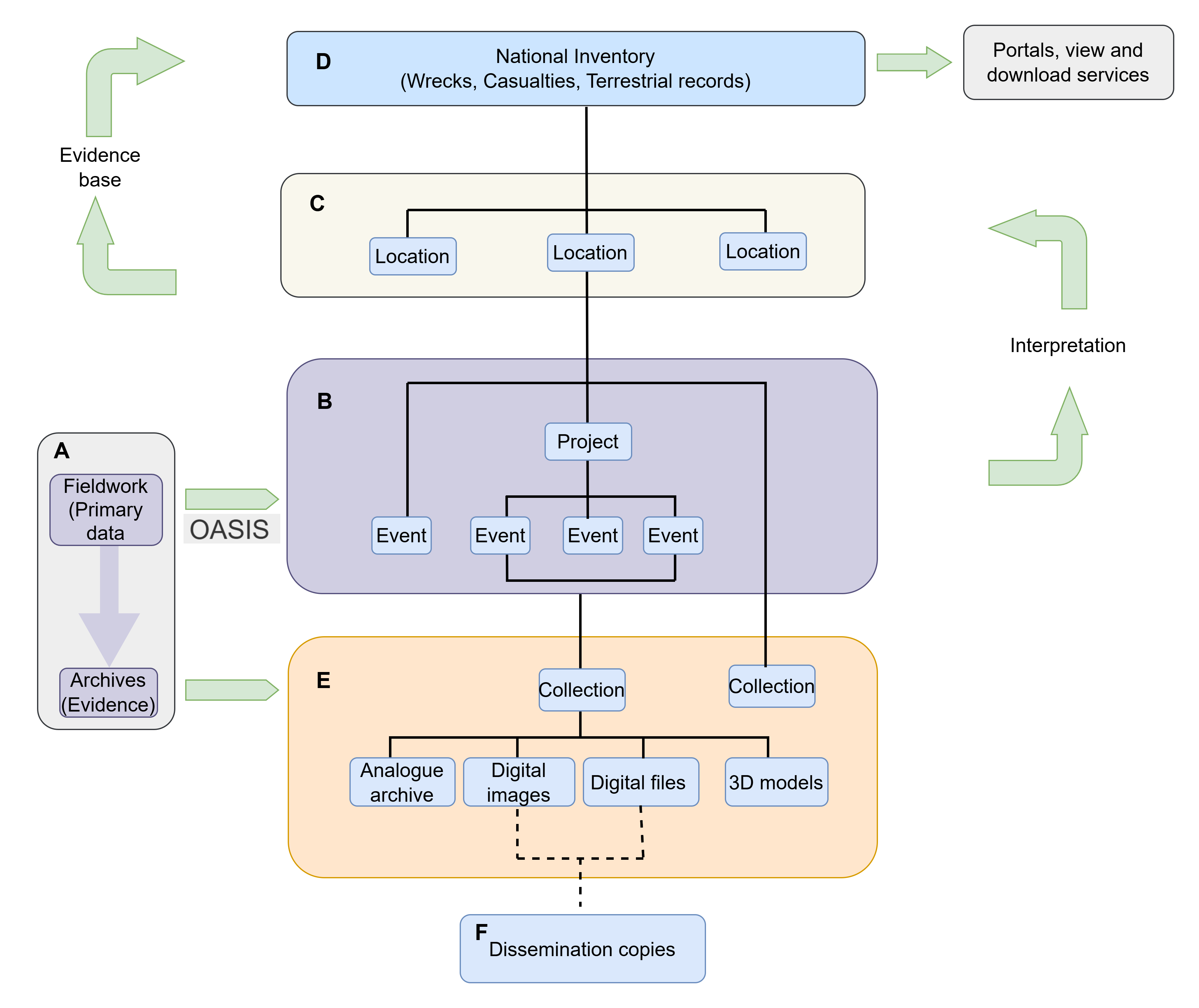
Information in the NRHE is organised by place (wreck), events and activities, and by archive. Each entry in the NRHE is uniquely identified through locally maintained URLs. Spatial datasets for both the designated datasets and the NRHE are published as web and download services under an Open Government Licence through the Scottish Government Spatial Data Infrastructure portal and via trove.scot.
Most of the information in the maritime record is drawn from the UK Hydrographic Office wrecks database or from comprehensive gazetteers of reported losses from documentary sources. This information can be quite technical or very brief and sometimes contradictory. Although primarily a record of loss, originally intended to inform offshore planning decisions, it is also publicly accessible online and more needs to be done to develop that aspect of the record.
Case studies explore some of the challenges in untangling the record and consider how to develop content of the record from a range of sources. These range from linking to related specialist websites to making more and better use of project archives so that the public can virtually explore difficult to access wrecks. However, exploring the potential highlights serious omissions in project archives as all too often much of the expensively gathered primary survey data is not archived, preventing subsequent reuse from monitoring the conditions or wrecks and the surrounding seabed over time to publishing 3D models to greatly improve public engagement with our online content. Following the ethos of MEDIN to 'measure once, use many times' (MEDIN 2025) much more can be made of project archives and related online resources to enhance the public experience of the maritime record provided that data is archived in the first place.
Corresponding author: Peter McKeague
[email protected]
Historic Environment Scotland
Figure 1: Relationships between the key components of the National Record of the Historic Environment (NRHE): site and wreck records; the events (activities) that inform our understanding of those records; and the associated archive from fieldwork and research (Crown Copyright Historic Environment Scotland 2026).
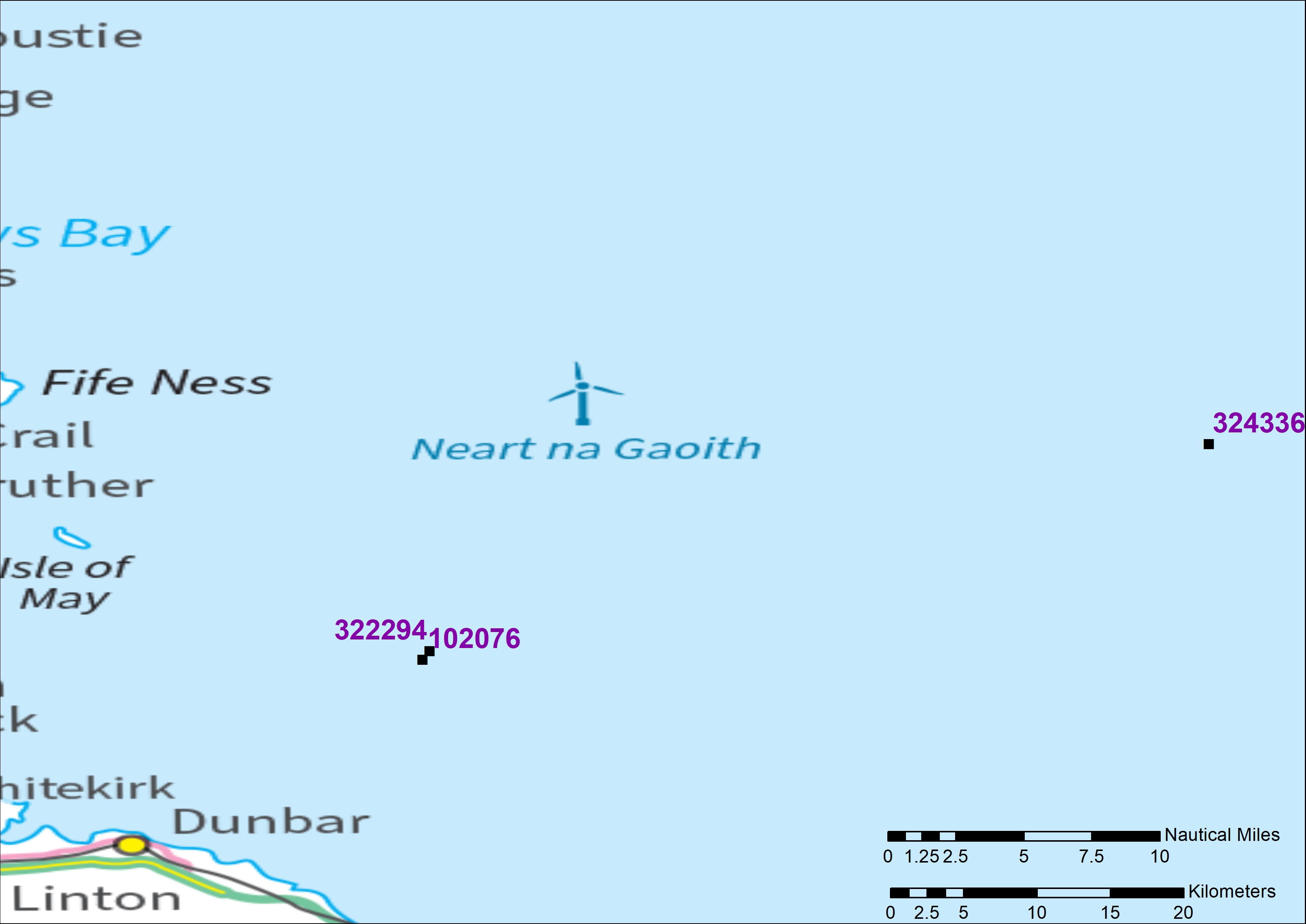
Figure 2: Reported locations for the wreck site of the World War I German submarine U12 recorded in the NRHE. Each wreck location is labelled with its NRHE ID. (Crown Copyright Historic Environment Scotland 2026). Contains OS data © Crown Copyright [and database right] [2026].
Figure 3 [video]: Dissemination copy of video footage (NRHE Archive ID 1471524) from an archaeological dive on the Duart Point wreck presented on trove.scot and hosted on Vimeo.
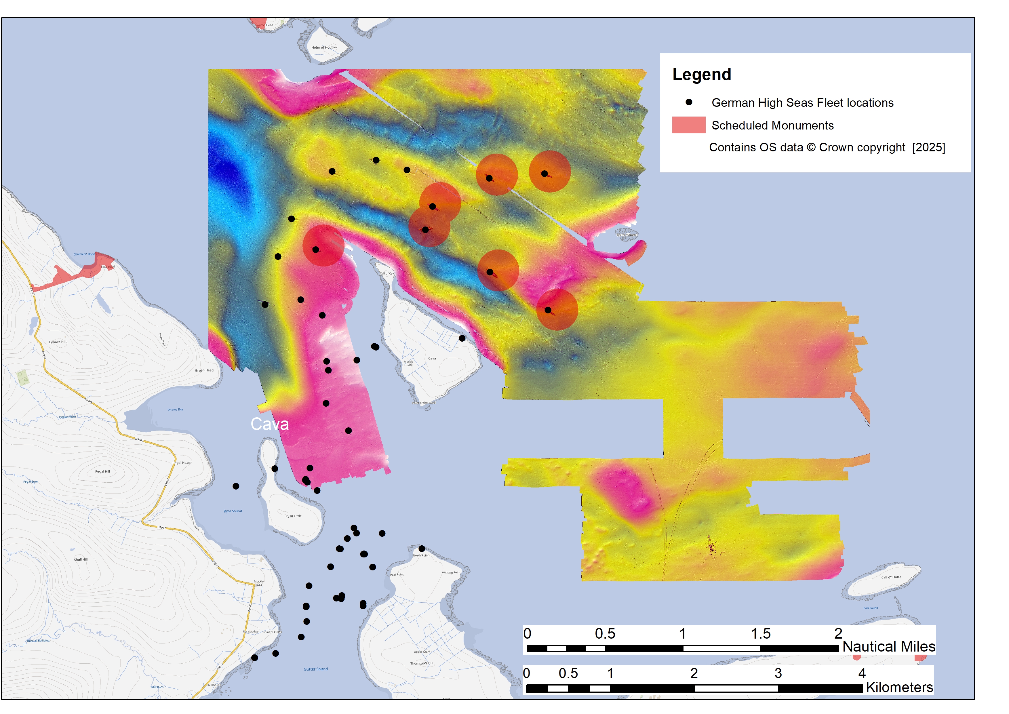
Figure 4: Bathymetric data of the seabed from the 2001 and 2006 ScapaMap surveys showing the locations of the German High Seas fleet wreck sites and scheduled area (Crown Copyright Historic Environment Scotland 2025) (after Forbes 2006). Contains OS data © Crown Copyright [and database right] [2026].
BGS and NGDC 2025 'Legal Obligations and Drilling Guidance', [online] Keyworth: British Geological Survey (BGS) and National Geoscience Data Centre (NGDC). https://www.bgs.ac.uk/ngdc/download/legal-obligations-and-drilling-guidance/ [Last accessed: 24 February 2026].
Brady, K. 2017 'The Zeepaard and the Blind Harbour wreck. Investigations of two 17th-century wrecks in Broadhaven Bay (County Mayo, Ireland)' in J. Gawronski, A. van Holk, and J. Schokkenbroek (eds) Ships And Maritime Landscapes: Proceedings of the Thirteenth International Symposium on Boat and Ship Archaeology, Amsterdam 2012, Eelde: Barkhuis. 416–422. https://doi.org/10.2307/j.ctt20p56b6
CIfA 2014 'Standard and Guidance for Nautical Archaeological Recording and Reconstruction', Reading: Chartered Institute for Archaeologists https://www.archaeologists.net/sites/default/files/2023-11/CIfA-SandG-Nautical-Archaeology-2020.pdf [Last accessed: 24 February 2026].
Christie, A., Heath, K. and Littlewood, M. 2014 'Scapa Flow 2013 Marine Archaeology Survey. Final Report', Kirkwall: Orkney Research Centre for Archaeology (Marine). https://www.trove.scot/archive/1769602 [Last accessed: 24 February 2026].
Firth, A. 2011 'Marine geophysics: integrated approaches to sensing the seabed' in D. Cowley (ed) Remote Sensing for Archaeological Heritage Management: Proceedings of the 11th EAC Heritage Management Symposium, Reykjavík, Iceland, 25–27 March 2010, Brussels: Europae Archaeologiae Consilium. 229-239. PDF [Last accessed: 24 February 2026]
Forbes, B. 2002 'ScapaMAP 2000–2002', Orkney: Heriot-Watt University, School of Life Sciences. https://www.trove.scot/archive/1769592 [Last accessed: 24 February 2026].
Forbes, B. 2006 'ScapaMAP2: Marine Heritage Monitoring with High-Resolution Survey Tools: Scapa Flow 2001–2006 Final Report', Stromness: Sula Diving https://www.trove.scot/archive/1769548 [Last accessed: 24 February 2026].
Heath, K. and Thomson, M. 2019 'Scapa Flow Underwater Salvage Sites Survey: Phase 2 Report', Orkney: SULA Diving and ORCA, UHI Archaeology Institute https://www.trove.scot/archive/2835145 [Last accessed: 24 February 2026].
Henry, S., Heath, K. and Littlewood, M. 2018 'High Seas Fleet Salvage Sites Report', ORCA Marine, UHI Archaeology Institute https://www.trove.scot/archive/1592698 [Last accessed: 24 February 2026].
Historic England 2025 Marine Geophysics: Data Acquisition, Processing and Interpretation Guidance Notes, 2nd edn, Swindon: Historic England. https://historicengland.org.uk/images-books/publications/marine-geophysics-data-acquisition-processing-interpretation/ [Last accessed: 24 February 2026].
Joint Nautical Archaeology Policy Committee 1995 JNAPC Code of Practice for Seabed Development, Portsmouth: Joint Nautical Archaeology Policy Committee.
Larn, R. and Larn, B. 1998 Shipwreck Index of the British Isles: Volume 4, Scotland, London: Lloyd's Register of Shipping.
MEDIN 2025 'MEDIN Business Plan 2024–2029', Marine Environmental Data and Information Network. https://medin.org.uk/sites/medin/files/documents/Business_Plan_2024_2029_final.pdf [Last accessed: 24 February 2026]
Marriott, J. 1987 Disaster at Sea, London: Ian Allan.
Martin, C. (ed) 2017 A Cromwellian Warship Wrecked off Duart Castle, Mull, Scotland, in 1653, Edinburgh: Society of Antiquaries of Scotland. https://doi.org/10.9750/9781908332370
McCartney, I. 2022 Echoes from the Deep: Inventorising shipwrecks at the national scale by the application of marine geophysics and the historical text, Leiden: Sidestone Press. https://www.sidestone.com/books/echoes-from-the-deep [Last accessed: 24 February 2026].
McKeague, P. 2025 'Scotland's National Record of the Marine Historic Environment' in B. Sloane and Unpath'd Waters Consortium (eds) Final Report - Unpath'd Waters: Marine and Maritime Collections in the UK, Towards a National Collection, Zenodo. 28–30. https://doi.org/10.5281/zenodo.14888571
Nimmo, E. and McKeague, P. 2018 'Digital archives – more than just a skeuomorph' in M. Matsumotu and E. Uleberg (eds) CAA 2016: Oceans of Data. Proceedings of the 44th Conference on Computer Applications and Quantitative Methods in Archaeology, Oxford: Archaeopress. 261–271. https://doi.org/10.2307/jj.15135958.28
Oxley, I. 2002 'Scapa Flow and the protection and management of Scotland's historic military shipwrecks', Antiquity 76(293), 862–868. https://doi.org/10.1017/S0003598X00091353
O'Connor, L. 2023 Virtual Reality Geographical Information Systems (VRGIS) – Unlocking Geospatial Capabilities Within a Heritage Immersive Experience, Unpublished MSc thesis, Glasgow School of Art.
Richards, J., Wright, H., Evans, T. and Pagé-Perron, É. 2025 'Cargo Inventory – the collections sample' in B. Sloane and Unpath'd Waters Consortium (eds) Final Report – Unpath'd Waters: Marine and Maritime Collections in the UK, Towards a National Collection, Zenodo. 54–61 https://doi.org/10.5281/zenodo.14888571
Roberts, M. and Quinn, R. 2025 'Voyages of discovery 2 – Science and the sea: 11.1 Introduction' in B. Sloane (ed) Unpath'd Waters Consortium, Towards a National Collection, Zenodo. 86–87. https://zenodo.org/records/14888571
Rowland, C. and Anderson, J. 2010 'WreckSight: revealing our submerged maritime heritage', VAST 2010: The 11th International Symposium on Virtual Reality, Archaeology, and Cultural Heritage, 39–45. https://doi.org/10.2312/VAST/VAST10/039-045
SCARF 2022 Perth and Kinross Archaeological Research Framework, [online] Society of Antiquaries of Scotland, Edinburgh: Scottish Archaeological Research Framework (SCARF). https://scarf.scot/regional/pkarf/ [Last accessed: 24 February 2026].
Schmidt, A., Linford, P., Linford, N., David, A., Gaffney, C., Sarris, A. and Fassbinder, J. 2016 'EAC Guidelines for the Use of Geophysics in Archaeology: Questions to Ask and Points to Consider', Namur, Belgium: Europae Archaeologia Consilium (EAC), Association Internationale sans But Lucratif (AIBL), Achaeolingua. https://zenodo.org/records/10671299
Sloane, B. and Unpath'd Waters Consortium 2025 Final Report - Unpath'd Waters: Marine and Maritime Collections in the UK, Towards a National Collection, Zenodo. https://doi.org/10.5281/zenodo.14888571
Whittaker, I.G. 1998 Off Scotland: A Comprehensive Record of Maritime and Aviation Losses in Scottish Waters, Edinburgh: C-Anne Publishing.
Woolmer-White, G. and Strachan, D. 2022 'The Carpow Log Boat' in Perth and Kinross Heritage Trust (ed) Perth and Kinross Archaeological Research Framework: Case Studies, Society of Antiquaries of Scotland. Edinburgh: Scottish Archaeological Research Framework. https://scarf.scot/regional/pkarf/perth-and-kinross-archaeological-research-framework-case-studies/the-carpow-log-boat/ [Last accessed: 24 February 2026].
Internet Archaeology is an open access journal based in the Department of Archaeology, University of York. Except where otherwise noted, content from this work may be used under the terms of the Creative Commons Attribution 3.0 (CC BY) Unported licence, which permits unrestricted use, distribution, and reproduction in any medium, provided that attribution to the author(s), the title of the work, the Internet Archaeology journal and the relevant URL/DOI are given.
Terms and Conditions | Legal Statements | Privacy Policy | Cookies Policy | Citing Internet Archaeology
Internet Archaeology content is preserved for the long term with the Archaeology Data Service (ROR). Help sustain and support open access publication by donating to our Open Access Archaeology Fund.
 Home
Home