Cite this as: Savine, B. et al. 2026 Romano-British Agricultural Land Management Adjacent to the Dringhouses Roadside Settlement, York: Archaeological investigations Abbeyfields House, Regency Mews, Dringhouses, York, Internet Archaeology 71. https://doi.org/10.11141/ia.71.8
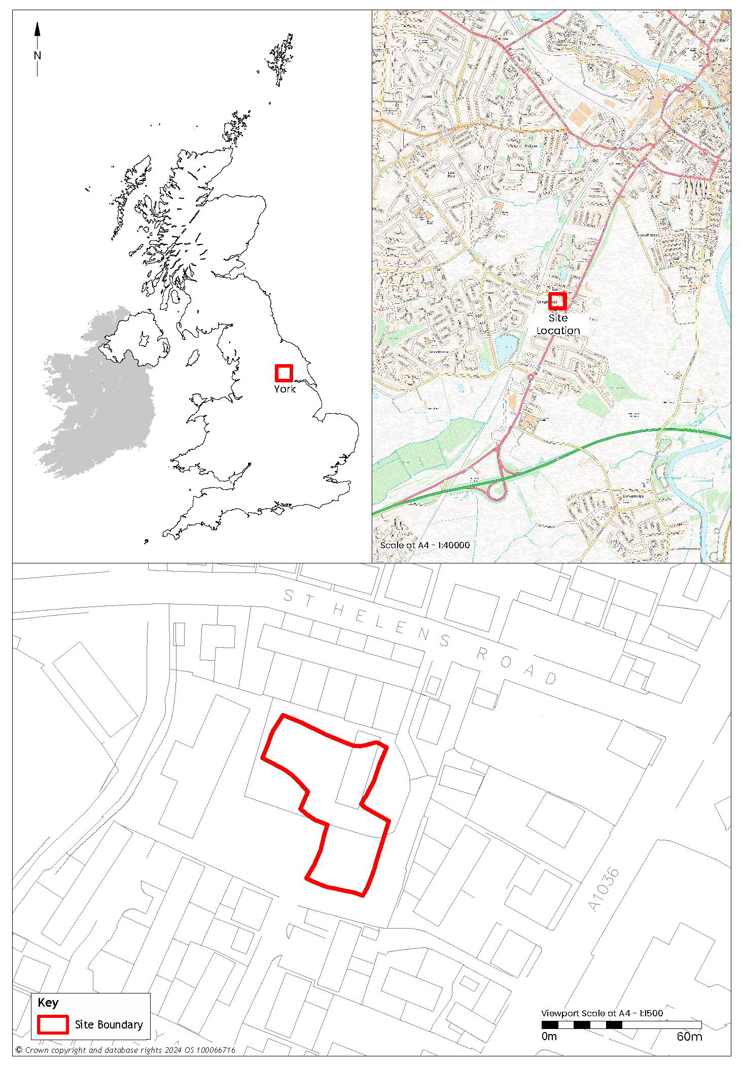
An archaeological strip, map and sample excavation (SMS) was conducted between March and May 2022 by York Archaeology (YA) in advance of development at Abbeyfield House, 27 St Helen's Road, Regency Mews, Dringhouses, York, YO24 1HR (53.940058, -1.1085301). The site was located approximately 2.5km south-west of York city centre and incorporated land formerly occupied by the house and grounds of a residential property at 27 St Helen's Road, as well as a small area of open ground to the south-west of the property (Figure 1). Prior to development, the site was fairly flat with a slight fall producing a gradient of approximately 2% south-east to north-west, which ranged from 14.6m to 13.44m AOD (above ordnance datum). The underlying bedrock is sandstone of the Sherwood Sandstone Group in an area that is straddled by two superficial geologies; to the east, York Moraine Member sand, clayey and gravelly deposits, and to the west, Alne Glaciolacustrine Formation clay and silts that accumulated in the proglacial lake that formed west of the York Moraine.
Investigation of the site revealed remains associated with agricultural land management dating to the late 1st to 3rd century CE, which were adjacent to a Roman-period roadside settlement located approximately 2.5km south-west of the military and civilian settlement at York. Discoveries included ditches forming a field system and a timber cask-lined well, finds from which indicate use by residents of buildings fronting onto the nearby road. The results contribute important new evidence for the land use, landscape character and development of Roman Dringhouses and the wider extramural area of York.
The site was located at Dringhouses, formerly a village around 3km south-west of York and now a suburb of the city. This area has produced evidence of Roman occupation and land use adjacent to the main south-western approach road to York from Calcaria (Tadcaster), designated as Road 10 by the Royal Commission (RCHME 1962, 3). The route of the road follows a ridge formed by a glacial moraine, either side of which extends the low-lying land of Micklegate Stray, known as the Hob Moor, to the north-west and the Knavesmire to the south-east. The well-drained sandy and loamy soils of the York Moraine would have offered significant agricultural advantages over the neighbouring low-lying, flood-prone land. This has led to speculation that the prehistoric moors, marshes and woodlands around this dominant landscape feature were settled to some degree, particularly at the point where the Rivers Ouse and Foss breach the moraine at York (Raine 1893, 1–2; VCH 1961, 322).
The glacial moraine enabled the passage of people across the Vale of York and exploitation of local resources from at least the Neolithic period (Roskhams and Neal 2020, ix and xiii). Despite this, evidence for prehistoric activity in the immediate area is limited, but includes five Neolithic polished stone axes found in Dringhouses on separate occasions (Macnab and Marwood 1998, 4). The presence of Bronze Age burials and artefacts at sites on, or close to, the morainic ridge further to the east, for example at Heslington East, imply the presence of round barrows near this important communication route (Roskhams and Neal 2020, 98). To date, no evidence for Bronze Age activity has come to light at Dringhouses, while indications of later prehistoric activity are sparse, being represented by a few sherds of possible Iron Age pottery recovered from the Fox public house (Ottaway 2011, 361) and a potentially prehistoric crouched burial at the former Starting Gate public house (McComish 2004, 8).
Evidence for Roman activity in the vicinity is extensive, with indications that a civilian settlement developed next to the Roman road (Ottaway 2011, 363). The division of land appears to have begun in the late 1st century CE with the cutting of ditches and gullies respecting the line of the road. Evidence for structures has been found at several sites; a possible construction cut for a building at 52–60 Tadcaster Road (Finlayson 1995, 8), a cobbled surface at The Fox public house (Macnab 1997, 4) and late 2nd-century building foundations at The Starting Gate public house (McComish 2004, 20–2).
The network of ditches and gullies dividing and helping to drain the land indicate that agriculture was likely a key feature of the settlement, and were certainly present on and in the vicinity of the current site. For example, multiple parallel ditches were found at 27 St Helen's Road in 1997 (Macnab and Marwood 1998, 8), the south-east continuation of which was encountered during evaluation of the present 27 St Helen's Road, Regency Mews site in 2018 (Boast 2018, 10). This sequence of ditches is thought to indicate the presence of an important boundary in the late 1st to mid-3rd century CE (Macnab and Marwood 1998, 8).
Craft activity appears to have been another aspect, as demonstrated by iron-smelting slag at The Starting Gate site. Evidence for metalworking may provide some context to the carved stone relief, found in 1860 in the grounds of Dringhouses Manor, opposite the Starting Gate site, which depicts a smith working away with hammer and tongs. The Royal Commission interprets this piece as a tombstone (RCHME 1962, 128), but Ottaway (2011, 341) suggests that it is more likely an altar dedicated to Vulcan, the Roman god of fire and the forge. An abundance of Ebor ware flagons, amphora and mortaria, again found at The Starting Gate site, suggest another feature of the settlement's purpose involved the sale of food and drink (McComish 2004, 20; Ottaway 2011, 363).
A number of Roman burials were discovered in Dringhouses in the 18th and 19th centuries, including five stone coffins, one of which was found in the yard of the Cross Keys Inn, and a small cemetery was uncovered near the junction of St Helen's Road with Tadcaster Road (RCHME 1962, 107). More recently, three burials were found at The Starting Gate site (McComish 2004, 23), another at The Fox public house (Macnab 1997, 30–1) and five inhumation burials were recorded at 26–28 Tadcaster Road (Whitehouse 2019, 21). In addition, a pottery face vase from the St Helen's Road area may have originated from a burial (RCHME 1962, 107).
Evidence for early medieval activity in the area is limited. The name 'Dringhouses' could be from the old English 'dreng', meaning a free tenant, or the old Norse 'drengr', a young man or servant (Ekwall 1960, 151). Early documentary evidence indicates that Dringhouses was a detached parish of the predecessor to Holy Trinity Priory, Micklegate, suggesting an Anglo-Scandinavian or early medieval settlement or manor at this location (Macnab and Marwood 1998, 4).
Archaeological evidence for medieval activity has typically been reliant on the recovery of pottery from garden or plough soils, for example at The Fox public house, where a small pottery assemblage spans the 12th to 14th centuries (Macnab 1997, 18 and 32). Local occupation and use of fields during this period has also been recorded at 26–30 Regency Mews, where a ditch and two lines of stakeholes close to it potentially had their origin in the medieval period, but may also have been post-medieval in date (Johnson 1997, 16).
In the post-medieval period Dringhouses was an agricultural village with strip-holdings that most likely had their origins in the medieval period or earlier (Macnab and Marwood 1998, 5). Excavations at 26–30 Regency Mews produced evidence of post-medieval quarrying (Johnson 1997, 16), suggesting that agriculture was not the sole activity at this time.
Map evidence shows that by 1930, tennis courts, croquet grounds and associated pavilion buildings occupied the site (OS 1930) and a degree of landscaping is implied by an escarpment at the rear of 40 Tadcaster Road, the south-east side of the current site (OS 1963). The former 27 St Helen's Road property was built in the 1970s.
The aim of the fieldwork was to establish the presence, date, nature, extent and condition of any archaeological deposits, features or structures present and to ensure preservation by record of any archaeological remains likely to be disturbed by development of the site.
The general objective of the fieldwork was the monitoring of site stripping, ground reduction operations and any other intrusive groundworks associated with the project and to identify any areas where further mitigation was necessary. This was done in order to identify, investigate and record any archaeological deposits, structures or features that were at risk of being impacted by the development scheme.
The following research questions were suggested by the results of the assessment report (Vatylioti et al. 2022), and are explored in the discussion below:
Prior to the SMS excavation, a watching brief was conducted during the installation of drainage, which involved excavation to a maximum depth of 1.52m Below Ground Level (BGL). Next, soil removal was carried out across the whole site by the principal contractor using a 15-tonne tracked excavator fitted with a toothless bucket. Topsoil and subsoil, with a combined thickness ranging between 0.6m and 0.9m, was removed, exposing archaeological features cutting into the top of superficial geological deposits. Following conclusion of the SMS stage a watching brief was carried out along the north-western edge of the site where a 1.5m wide extension to the stripped area was mechanically cleared.
Where potential archaeological features were recognised, hand-cleaning was carried out to enable identification and definition of archaeological features. Investigative slots were then excavated across linear features and at locations where they intersected. Discrete features were initially half-sectioned and, where appropriate, fully excavated in order to expose the cuts of these features to their full extents.
Adverse weather conditions and poor drainage resulted in part of the north-western side of the excavation being constantly waterlogged. Attempts to drain the area using a pump were unsuccessful and as a result investigation of this area was less comprehensive than intended. Consequently, it was not possible to establish some relationships between the Group 1004, 1005, 1006 and 1007 ditches.
Stripping of the site revealed some variation in the top of superficial geological deposits. Ground level was at its highest to the south and south-east, producing a maximum height of 13.87m AOD, where soft, mid-orange/brown grey silty sand of the York Moraine Member predominated. The north and north-western part of the site was occupied by firm mid-yellow brown/orange silty clay belonging to the Alne Glaciolacustrine Formation, which at its lowest point fell to 12.58m AOD.
The evidence for activity during the Roman period suggests a focus on the improvement and management of the land for agriculture, with the cutting of ditches providing drainage and land division.
A grid pattern of ditches was established, extending north-east/south-west and north-west/south-east, and appears to have been in use for much of the early Roman period (Figure 2). Finds recovered from these ditches indicate that maintenance of land division and drainage, evident through extensive re-cutting, occurred over the course of the 2nd century and may have continued into the 3rd century.
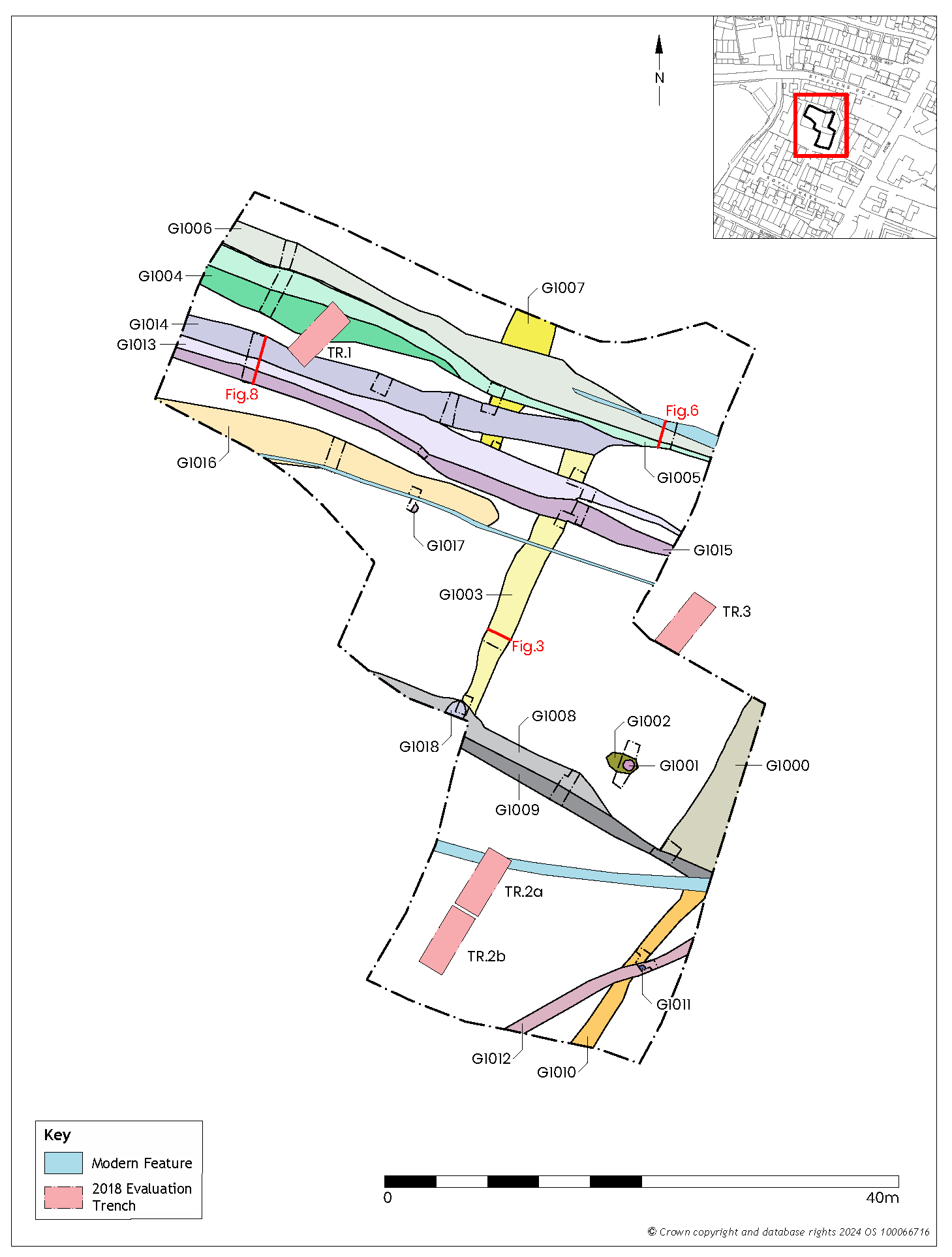
Three ditches ranged across the site on north-east/south-west alignments (Figure 2). All had been truncated by one or more later ditches, usually running at right-angles to them, suggesting that this grouping formed the earliest land management activity on the site. However, dating evidence recovered from the fills within these ditches and those cutting across them does not necessarily tally with this interpretation.
Ditch Group 1007
Ditch Group 1007 extended from the north-eastern boundary of the site over a distance of 10.6m, and was not found to continue south-west of where it was truncated by Ditch Group 1013. At its north-eastern end it was a maximum of 3.9m wide, narrowing to 1.57m at the south-west. The ditch was 0.45m deep and in profile had straight, moderately steep sides that gradually broke to a flat base.
The presence of standing water at the intersection of Ditch Groups 1006 and 1007 prevented direct investigation of their relationship. Nonetheless, their relationship is implied by that of Ditch Group 1005, which cut across Ditch Group 1007 at approximately 90° and was cut along its north-eastern side by Ditch Group 1006 after it had silted up, thereby suggesting that Ditch Group 1007 was the earliest.
The relationship of Ditch Group 1007 to Ditch Group 1014 was unclear owing to the similarity of fills. Nonetheless, an earlier date for 1007 can be inferred based on the fact that 1014 cut 1013, which itself truncated the south-western end of 1007 (see above).
Romano-British pottery and 1st–4th century CE Ceramic Building Material (CBM) was recovered from its fill, recorded as (1051) and (1070).
Ditch Group 1003
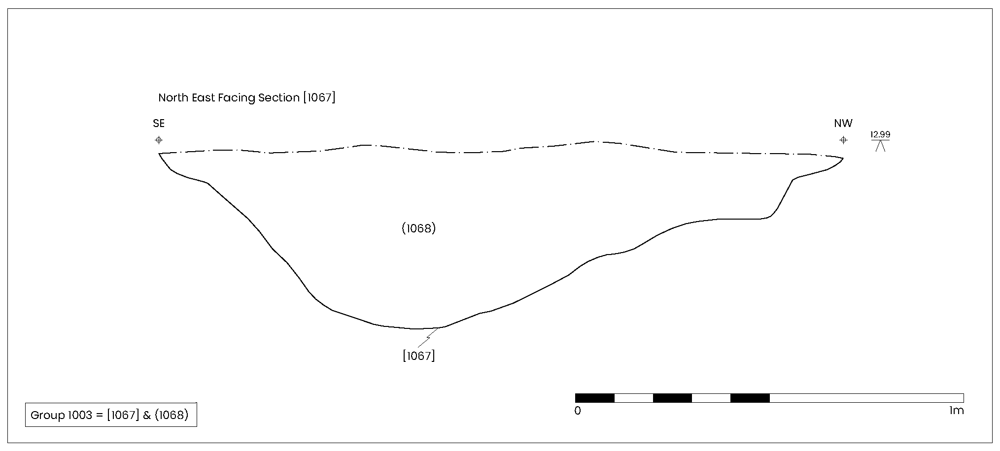
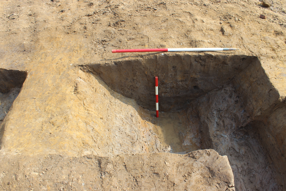
The ditch assigned to Group 1003 was situated 4.88m south-east of Ditch Group 1007 and was also orientated north-east/south-west (Figure 2). It measured 22.34m long and was 1.2–2.34m wide. In profile the ditch had moderately steep, convex sides that gradually broke to a broad U-shaped base. It was consistently close to 0.5m deep along much of its length (Figure 3) but was 0.66m deep at its north-eastern end and only 0.21m deep at its south-western end.
Standing water prevented thorough investigation of the north-eastern part of the site; consequently it was not possible to examine where Ditch Group 1003 was thought likely to intersect with Ditch Groups 1005, 1006 and 1014, although it did not appear to continue beyond them to the north-east. It was, however, possible to establish that Ditch Groups 1013 and 1015 cut the ditch, and it was also cut by Ditch Group 1008 close to the south-western boundary of the site.
Mid-Roman pottery was recovered from ditch fill (1060), the uppermost of two fills close to the north-eastern end of the ditch where it intersected with Ditch Group 1013, in which more mid-Roman pottery was present. Approximately 12m further to the south-west, pottery of mid-Roman date and a single sherd of mortaria, dated to 200–400 CE, was recovered from (1068), the single fill of the ditch identified in this location. In addition, CBM recovered from this feature has been dated to the 1st–4th century CE.
Analysis of charcoal recovered from ditch fill (1068) suggests that fuel used nearby originated from shrubby oak woodland, where apple sub-family, plum-type and hazel also grew in what may have been managed woodland.
Ditch Group 1010
Close to the south-eastern boundary of the site, 20m south-east of Ditch Group 1003, was a third north-east/south-west aligned ditch, Ditch Group 1010 (Figure 2), although it had a slightly different orientation to Ditch Groups 1003 and 1007. It measured 14.94m long, 1.1–1.78m wide and 0.15m deep with a shallow, broad V-shaped profile (Figure 4).
At its north-eastern end Ditch Group 1010 was truncated by a modern power cable, resulting in the removal of any relationship with Ditch Group G1009. The only fill identified in Ditch Group 1010, Context (1102), contained pottery sherds dating to the 2nd century CE. Midway along its exposed length it was cut across by Ditch Group 1012, from which late 2nd-century CE pottery was recovered.
Close to the north-eastern boundary of the site was a grouping of closely related intercutting ditches (Figure 2), which had been impacted severely by later truncation. The intercutting occurred along the north-eastern sides of two of the three ditches, indicating a succession of re-cutting along the main axis of the ditch, each time migrating a little further to the north-east. They appeared to continue the line of a ditch found during excavation conducted in 1997 at the neighbouring 27 St Helen's Road site (Macnab and Marwood 1998, fig. 2). That feature was c. 3m wide and contained burnt bone and charcoal but was not excavated (Ottaway 2011, 359–60) and so a detailed comparison cannot be drawn.
Ditch Group 1004
The earliest ditch was that assigned to Ditch Group 1004. It extended approximately 21.32m from the north-western boundary of the site (Figure 2), although it was not possible to establish its south-eastern extent as it appeared to merge into Ditch Group 1005. Measuring between 1.8 and 2.32m wide, Ditch Group 1004 had a broad but shallow U-shaped profile, 0.25m deep, with a moderately steep, concave, side to the south-west. This feature probably equates to ditch cut [1006], found in evaluation Trench 1, and from which four sherds of Romano-British pottery and two sherds of late medieval (14th/15th century) pottery were recovered (Boast 2018, 8; fig. 7). Despite an absence of dateable material in Ditch Group 1004, a Romano-British date is implied by the presence of Roman pottery in Ditch Group 1005, which cut along its north-eastern side (Figure 5). This also suggests that the medieval pottery found in the evaluation Trench 1 ditch was intrusive.
Ditch Group 1005
Ditch Group 1005 appears to have extended the full 41.74m width of this part of the site (Figure 2). However, significant variations in the depth and profile of the feature were recorded at either end of it. North-west of its intersection with Ditch Group 1003 it measured 1.31–1.89m wide and around 0.26m deep (Figure 5), but truncation by Ditch Group 1006 further to the south-east meant that only a 1.1m width was visible (Figure 6). At its widest point it had a broad, shallow, generally flat-based U-shaped profile, was 0.18m deep and contained a single fill (1025), from which a Roman iron nail was recovered.
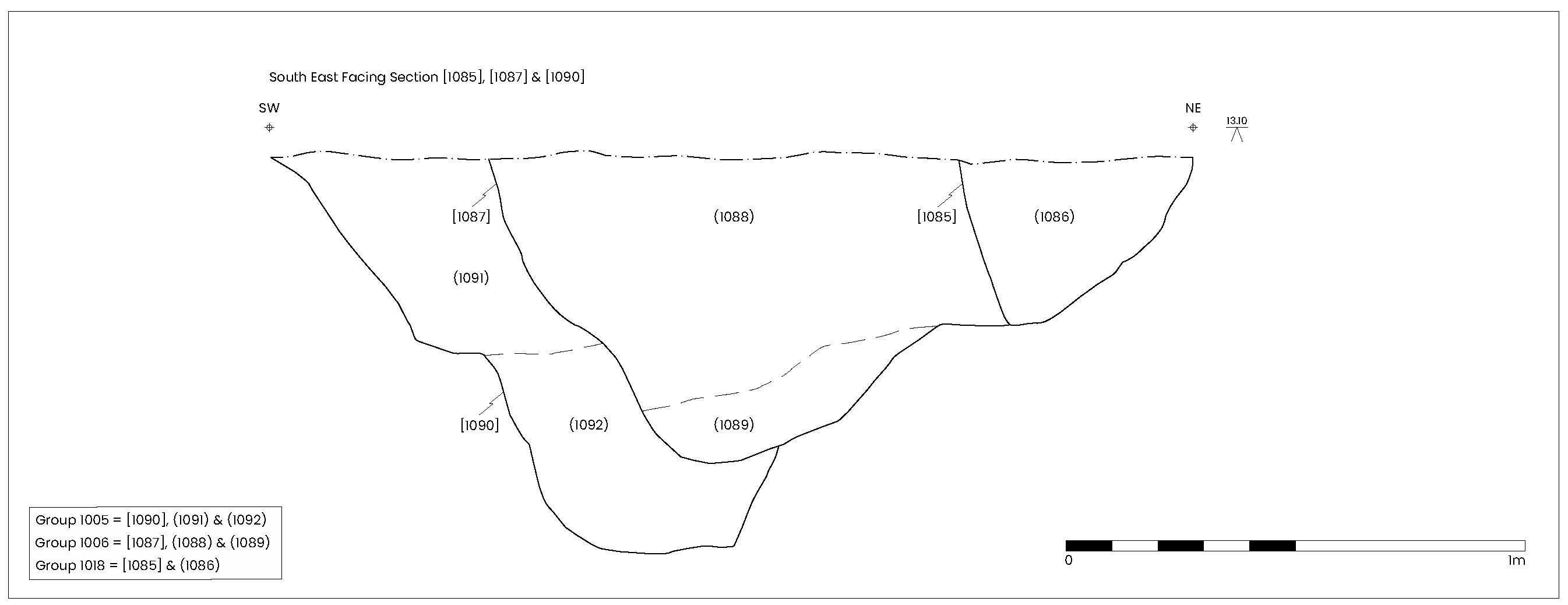
Excavation, close to where Ditch Group 1005 cut across the top of Ditch Group 1007, revealed a broad shallow U-shaped profile that was 1.15m wide and 0.25m deep. The single fill (1049), contained early Roman pottery and CBM fragments dating to the 1st–4th century CE.
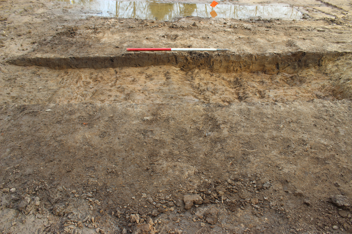
At the south-eastern end of Ditch Group 1005 the cut [1090], was approximately 1.11m wide and 0.85m deep with a step midway along its south-western side. It contained two distinct fills (1091) and (1092), from which early to mid-Roman pottery sherds and CBM dating to the 1st–4th century CE were retrieved.
What accounts for the differences in profile shape, depth and number of fills observed at either end of Ditch Group 1005 is not clear, but may be the result of one, or a combination of factors. The north-western end of the site could have been subjected to a more significant degree of truncation, as suggested by the relatively shallow depths of ditches there. Alternatively, the deeper profile seen at the south-eastern end of Ditch Group 1005 could be the result of successive re-cutting, which may not have extended further to the north-west. It may even be the case that the stepped profile recorded in ditch cut [1090], with distinct deposits above and below the level of that step, represents an earlier, deeper ditch, filled by (1092), and later re-cut to a shallower depth that subsequently filled with (1091). Another possible explanation is that there was a need for deeper ditches at the south-eastern end of the site in order to manage drainage.
It is possible, but not entirely certain, that Ditch Group 1005 equated to ditch Context 1005 in evaluation Trench 1 (Boast 2018, 8; fig. 7). The alignments of the two linear features were slightly different, with that in evaluation Trench1 recorded as running closer to a northwest/south-east axis than Ditch Group 1005, but this may have been the result of the limited extent of the evaluation trench. A small quantity (four sherds) of late 13th/14th century pottery was recovered from evaluation Trench 1, all of which were small and abraded (Jenner 2022, 16). Nonetheless, given that 18 sherds of Roman pottery were recovered from three interventions across Ditch Group 1005, it seems probable that the medieval pottery recovered during the evaluation was intrusive.
Ditch Group 1006
The latest ditch in this grouping was designated Ditch Group 1006. Similar to Ditch Group 1005, it ran the full width of the site and had a broad, shallow U-shaped profile at its north-western end (Figure 7) and a much deeper, stepped profile to the south-east (Figure 6). To the north-west it measured 2.19m wide and 0.36m deep and contained a single fill (1021), which contained Romano-British pottery. In this area there was a slight gap between this ditch and that in Ditch Group 1005 but towards the south-east it cut along the north-eastern side of Ditch Group 1005. In that area it measured 1.03m wide, was 0.68m deep and pottery dating to the mid-Roman period was recovered from (1088), the upper of two fills.
No relationship between Ditch Group 1006 and Ditch Group 1007 was established. However, it was clear that Ditch Group 1006 was stratigraphically later than Ditch Group 1005, which cut Ditch Group 1007.
A short distance south-west of Ditch Groups 1004–6 was another grouping of three successive re-cuts of a north-west/south-east aligned ditch. The earliest of these was Ditch Group 1013 (Figure 2).
Ditch Group 1013
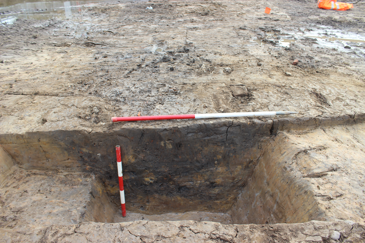
Ditch Group 1013 spanned the full 42m width of the site in this area (Figure 2). At its widest visible point, it measured at least 2.4m wide, although its full width at this point could not be determined because it was truncated by Ditch Group 1015 on its south-western side. In contrast, at the point where Ditch Group 1013 ran to the south-eastern site boundary, it was only 0.37m wide. Truncation from later re-cutting of the line of this feature had removed elements of the upper part of the profile of this ditch. Archaeological interventions across the north-west and central part of this ditch recorded an irregular profile with a base that tapered to a narrow, deep U-shape, producing an overall depth ranging from 0.86–0.92m where a full profile across the ditch was exposed (Figure 8). At the south-easternmost intervention the ditch measured 1.05m wide and 0.32m deep, but had a similar profile, with steep, flat, sides breaking sharply to a flattish base.
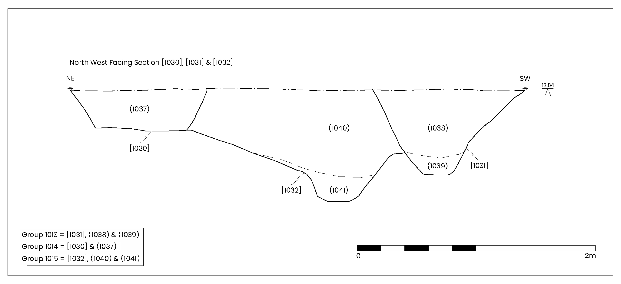
Interventions excavated along Ditch Group 1013 suggest that this feature cut across Ditch Group 1003 and Ditch Group 1007 after they had silted-up.
Pottery recovered from along the ditch dated to the 2nd century CE and 1st–4th century CE. CBM was also present.
Ditch Group 1015
Ditch Group 1015 extended the full 41.6m width of the site in this area. It truncated Ditch Group 1013 along much of its south-western edge, the two features only separating 8.5m from the south-eastern edge of the site. It ranged in width from 0.63–1.64m and in depth from 0.3–0.74m. Towards the north-west it had a V-shaped profile with a flat base (Figure 9) and became both broader and deeper to the south-east (Figure 9). The intervention excavated at the junction of Ditch Group 1015 and Ditch Group 1003 indicated that the north-west/south-east aligned ditch, Ditch Group 1015, cut across the other.
Dateable material was only present in the intervention excavated furthest to the north-west, which comprised fragments of CBM and Romano-British pottery dating to the 1st–4th century CE, along with some intrusive 13th–16th century plain tile.
Ditch Group 1014
Ditch Group 1014 was the latest in the central north-west/south-east aligned ditch grouping. It ran for approximately 36.5m from north-west to south-east before merging with Ditch Group 1005 in the north-eastern north-west/south-east aligned ditch grouping (Figure 2).
Ditch Group 1014 was inconsistent in the extent and form of its profile. To the north-west it was 0.6m wide and 0.17m deep with moderately steep flat sides, a sharp break of slope and a flat base (Figure 8). Towards its mid-point it was much wider and a little deeper, here retaining much the same shape in profile but measuring 0.28m deep (Figure 10). An intervention excavated further to the south-east had a broad U-shaped profile with straight moderately steep sides and a flat base. Here the ditch was larger still, measuring 0.64m deep and up to 2.58m wide. Throughout its length, between one and two fills were present in each intervention.
In the north-eastern part of the site Ditch Group 1014 appeared to intersect with those in Ditch Groups 1003 and 1004. Unfortunately, standing water in this part of the site prevented investigation of the relationship with those ditches, although as Ditch Group 1014 cut Ditch Group 1013, which itself truncated Ditch Group 1003, Ditch Group 1014 was the later feature.
Roman artefacts were collected from slots dug across the central part of Ditch Group 1014. CBM dating to the 1st–4th century CE was retrieved from contexts (1014), (1017) and (1020), while late 2nd to 3rd century pottery was also recovered from contexts (1017) and (1020), the ditch fills recorded towards the south-eastern end of the feature.
A third grouping of north-west/south-east aligned ditches was present approximately 16m south-west of the central grouping (Figure 2).
Ditch Groups 1008 and 1009
Two parallel ditches were identified in the central southern part of the site, but no stratigraphic relationship could be established between them. Both were approximately 22m long, although Ditch Group 1008 entered the site further to the north-west than Ditch Group 1009, and the former appeared to merge with the latter approximately 10m from the south-eastern limit of excavation (Figure 2).
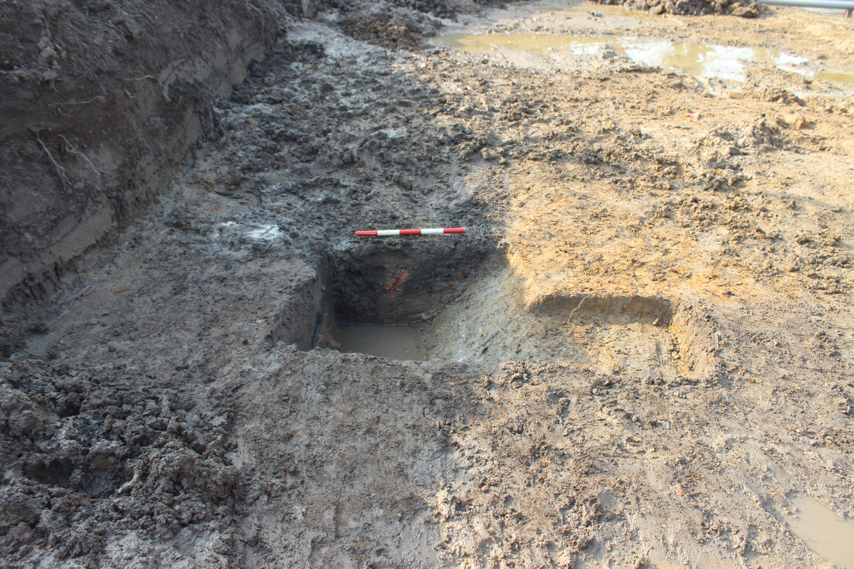
Both ditches had a shallow U-shaped profile, were approximately 1.4m wide and 0.25–0.3m deep. Ditch Group 1008 appeared to cut across and truncate the line of Ditch Group 1003 (Figure 11), but a modern pit at this intersection disrupted investigation of this relationship. Similarly, the presence of a modern power cable prevented investigation of any relationship between the ditches in Ditch Groups 1009 and 1010.
No artefacts were recovered from Ditch Group 1008; however, mid- to late-Roman pottery and CBM dating to the 1st–4th centuries CE was retrieved from fill (1094), midway along Ditch Group 1009.
Ditch Group 1012
A ditch in the south-eastern corner of the site was assigned to Ditch Group 1012. This linear feature did not follow the same grid pattern as the other ditches. It was aligned closer to north-east/south-west than Ditch Group 1010, which it cut across (Figure 2). It measured 14.5m long and extended from the eastern site boundary to the southern boundary. This feature was quite narrow and shallow, but was a little deeper and more clearly defined where it intersected with Ditch Group 1010. At that point it was found to be 0.9m wide, 0.21m deep and some 2nd-century CE pottery was recovered from its fill, Context (1104).
A small pit, Group 1011, was present at the intersection of Ditch Groups 1010 and 1012. The pit was cut by Ditch Group 1012 and extended to a further depth of 0.14m.
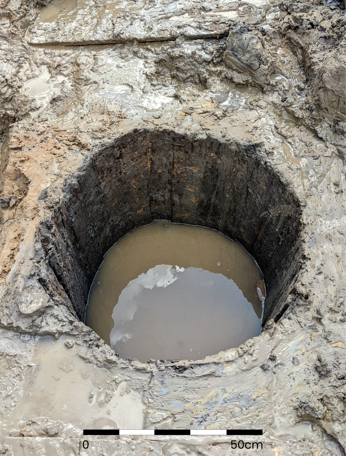
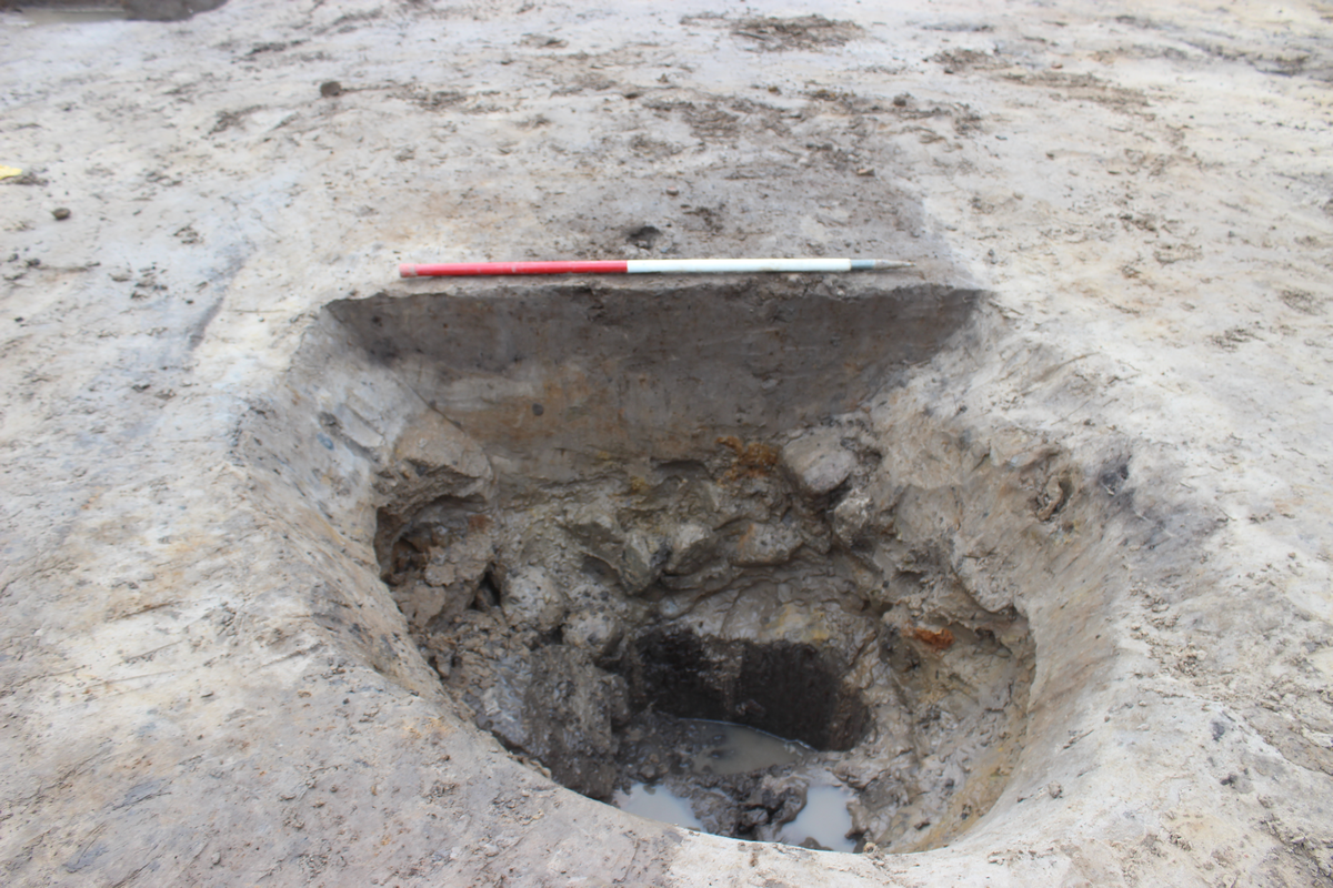
Well Group 1001: Roman cask-lined well
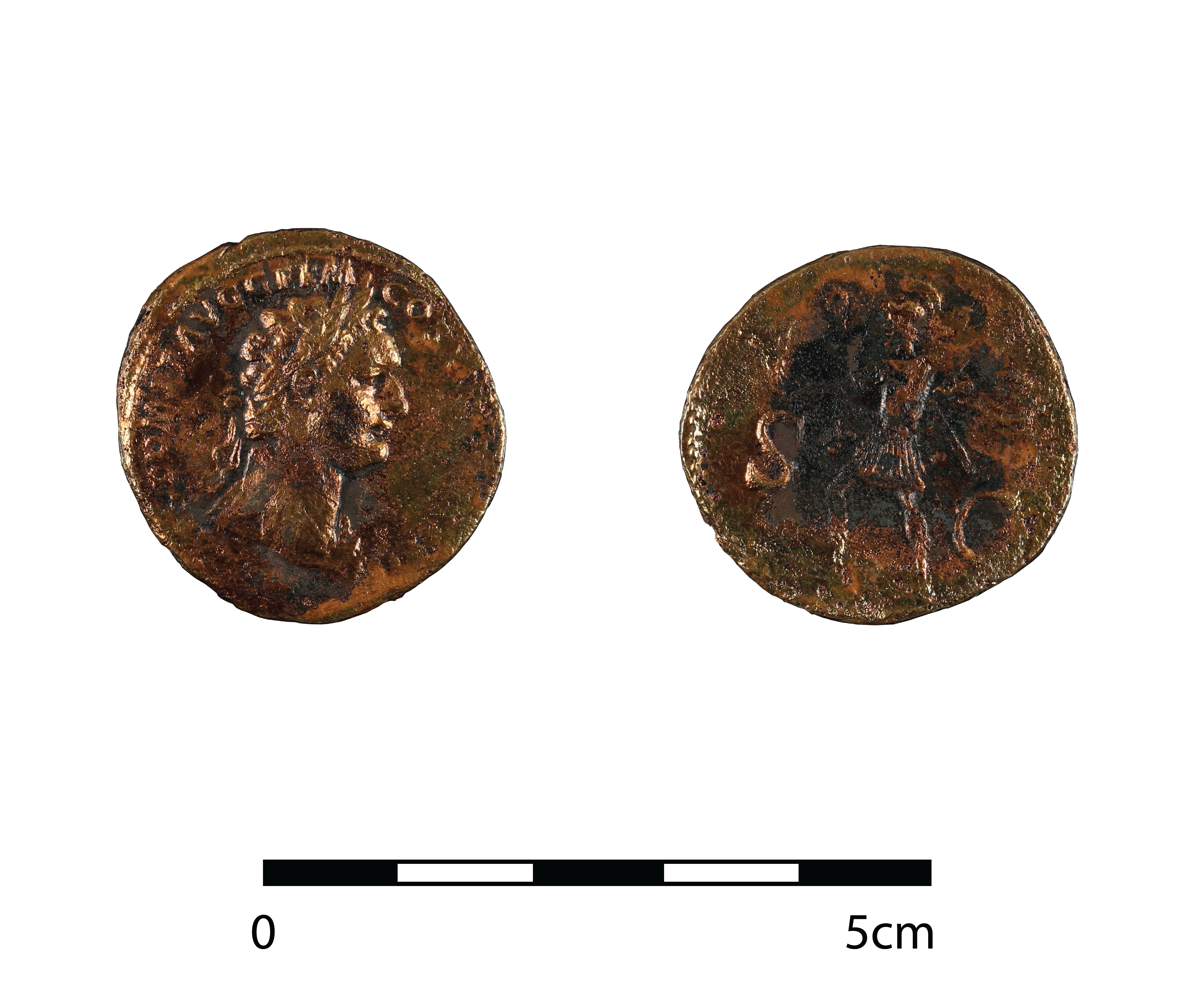
Cutting down 1.65m into the York Moraine deposits close to the south-eastern side of the site was a well, the base of which extended to approximately 11.70m AOD (Figure 2). A timber cask, from which the head piece had been removed, was preserved at the base of the well and had clearly been recycled as a lining intended to reinforce the sides of the feature (Figure 12). It comprised 23 Abies alba Mill. (silver fir) staves bound with hazel hoops. The maximum height of the cask was 0.642m and less than half the length of any stave had survived, leaving a maximum diameter of 0.75m (Allen 2022, 21–2).
The lower fill (1114) was a soft, patchy mid-grey sandy silt containing fragments of Quercus spp. (oak) and Fraxinus excelsior L. (European ash) board. At the base of the deposit was a copper-alloy coin (SF1), dating to 85 CE and depicting the Roman emperor Domitian (Figure 13). Also present were fragments of 2nd-century CE pottery, a large proportion of which were oxidised, and reduced white-slipped flagons dating to 120–200 CE. Above (1114) were more fragments of Quercus spp. board, which were collectively assigned to (1113). At the top of the well fill sequence was (1111), a soft, mid-grey clayey sandy silt which contained CBM dating to the 1st–4th century CE, 2nd-century CE pottery, some residual medieval pottery sherds and more wood offcuts.
The well provided conditions favourable for the preservation of waterlogged plant remains and pollen, and accordingly samples were recovered to elucidate the local environmental conditions. Both the pollen and plant macrofossils tentatively indicate disturbed ground and grassland in the locality. Wet or damp conditions are also suggested, which may be a direct reflection of the well itself, or, perhaps given the contemporary wet conditions, might also apply to the wider vicinity in the 2nd century CE.
Represented in the waterlogged plant remains assemblage were edible plants. These included forage foods such as hazelnuts and berries, while a small quantity of cereals, probably wheat or barley, were present in the upper well fill (1111). Also present was pollen from brassica and vetch. The edible plant remains were not present in sufficient quantity to suggest local cultivation, and as Batchelor (see 6.3) points out, are more likely to represent domestic discard.
Pollen from lime, birch and elm from the well complement the charcoal assemblage from Ditch Group 1003. Cumulatively the impression is of managed woodland present in small stands, either nearby or perhaps more extensively at some distance from the site.
Pit Group 1002
Cutting into the top of the well was a pit, Pit Group 1002 (Figure 2; Figure 14). Pit cut [1105], was sub-oval in plan; measured 2.1 × 1.5m with the long axis aligned east/west, and was 0.9m deep. Two of the pit fills (1106) and (1109), contained mid-Roman pottery sherds and CBM dating to the 1st–4th century CE. It is possible that the purpose of (1109), the earliest deposit in this pit, was to seal the top of the disused well.
Ditch/Furrow Group 1016
Positioned between 0.4 and 1.8m south-west of Ditch Group 1015 was a furrow, or what may have been the base of a shallow ditch, Ditch/Furrow Group 1016 (Figure 2; Figure 15). It extended approximately 35m into the site from the north-west, terminating approximately 2.8m from Ditch Group 1003. It measured up to 2.2m wide and was very shallow, at only 0.07m to 0.1m deep. Two slots were excavated through the feature in order to understand its stratigraphic relationship with Ditch Group 1017 (see 5.4) and determine its profile shape.
Three sherds of abraded medieval Gritty ware were recovered from the fills of this feature (1010) and (1122). Some Roman pottery was also present, but with the exception of two sherds of Baetican amphora, all were small and abraded. Post-depositional processes, for example, ploughing, could explain the generally small and abraded nature of the pottery present in Ditch/Furrow Group 1016. In addition, the wide, shallow form suggests this feature is best interpreted as a medieval furrow. However, the possibility remains that it was part of the Romano-British fields system. The Ditch/Furrow Group 1016 feature may be a continuation of parallel ditches, recorded as [1014] and [1016], in the neighbouring excavation carried out in 1997 at 27 St Helen's Road (Macnab and Marwood, 1998, fig. 2). Nine sherds of abraded Roman pottery were recovered from the surface of the features exposed in 1997, but they were not excavated (Ottaway 2011, 359–60), leaving some uncertainty regarding an equivalence with Ditch/Furrow Group 1016.
Pit Group 1017
Pit cut [1011] measured 0.65m in diameter, was 0.18m deep and cut into Ditch/Furrow Group 1016 (Figure 2). Both pit and ditch were truncated on their southern side by a later east/west aligned field drain [1123] (see 5.5). Roman pottery and CBM were present in the pit fill but were likely to have been residual, with dating provided by post-medieval pottery.
Feature Group 1018
Three modern features truncated earlier archaeological deposits: two land drains [1085] and [1123], and a pit [1075]. Both land drains ran north-west/south-east across the excavation area, with land drain [1085] cutting across Ditch Group 1003 and land drain [1123] cutting into the south-eastern end of Ditch Group 1006.
A modern pit [1075], was not distinct in plan but was seen when a slot was excavated at the intersection of features in Ditch Group 1003 and Ditch Group 1008.
Overlying the feature on the site was either made ground (1119) or subsoil (1118), and in areas that had formerly been gardens or open ground was topsoil (1117).
In total, 676 sherds were recovered, including two sherds of prehistoric-tradition handmade pottery, and 21 sherds of medieval pottery (intrusive in Romano-British deposits). When considering the results from statistical analyses undertaken (see Table 4), biases must be borne in mind, specifically the relatively small size of the assemblage, and the primary deposit of vessels in the well/pit group. Only pottery from secure stratified deposits relating to Phase 2 (Romano-British) activity is considered in the analyses below. Table 1 presents the whole assemblage including material from post-Roman phases; Table 2 presents all pottery by ware and class for Phase 2 activity.
| Ware | Count | % of count | Weight | % of weight | EVEs | % EVEs |
|---|---|---|---|---|---|---|
| Handmade prehistoric tradition | 2 | 0.3% | 12.2 | 0.1% | 0.0% | |
| Amphorae | 42 | 6.2% | 4786.3 | 37.9% | 115.5 | 10.5% |
| Amphorae/Coarse ware? | 1 | 0.2% | 8.9 | 0.1% | 0.0% | |
| Amphorae/Mortaria? | 3 | 0.4% | 10.5 | 0.1% | 0.0% | |
| Fine ware - samian ware | 27 | 4.0% | 211.5 | 1.7% | 39 | 3.6% |
| Fine ware - other | 11 | 1.6% | 34.2 | 0.3% | 43 | 3.9% |
| Mortaria | 3 | 0.4% | 319.1 | 2.5% | 0.0% | |
| Coarse ware | 566 | 83.7% | 7101.5 | 56.2% | 892.5 | 81.5% |
| Medieval | 21 | 3.1% | 142.5 | 1.1% | 5 | 0.5% |
| Grand Total | 676 | 100.0% | 12626.7 | 100.0% | 1095 | 100.0% |
Two sherds of handmade pottery were recovered, both of which may be prehistoric or Romano-British period in date (Table 1). The two body sherds provided limited diagnostic information and were found in Roman period (Phase 2) deposits; these handmade wares were produced in northern England from the Iron Age and production continued throughout the Roman occupation of Britain into the post-Roman period (Cumberpatch 2018; 2020; Gerrard 2012).
Amphorae with a contribution from Dr David Williams
In total, 42 sherds of amphorae were recovered (Table 1; Table 2), with 38 being from securely stratified, Phase 2 deposits and two sherds each recovered from Phase 3 and 4 deposits. Most of the sherds represented Baetican (Southern Spanish) Dressel 20 amphorae, a type of vessel originally used for transporting olive oil to Britain in the 1st to mid-3rd century CE. A small number of body sherds of Gaulish amphorae were also recovered. Four additional sherds were identified as possible amphora, with one of these perhaps being a coarse ware sherd, and three potentially being mortaria; all were in North Gaulish fabrics.
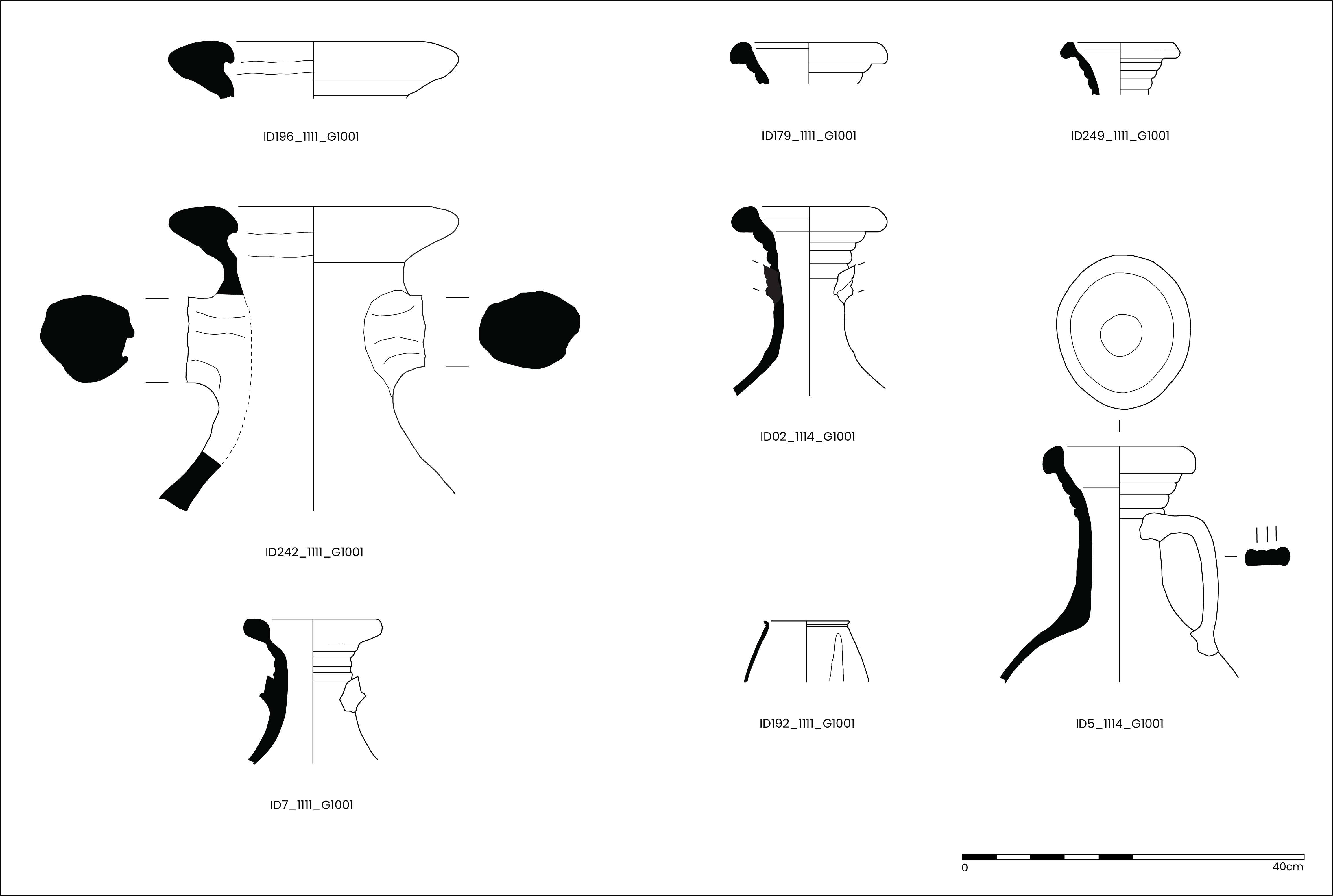
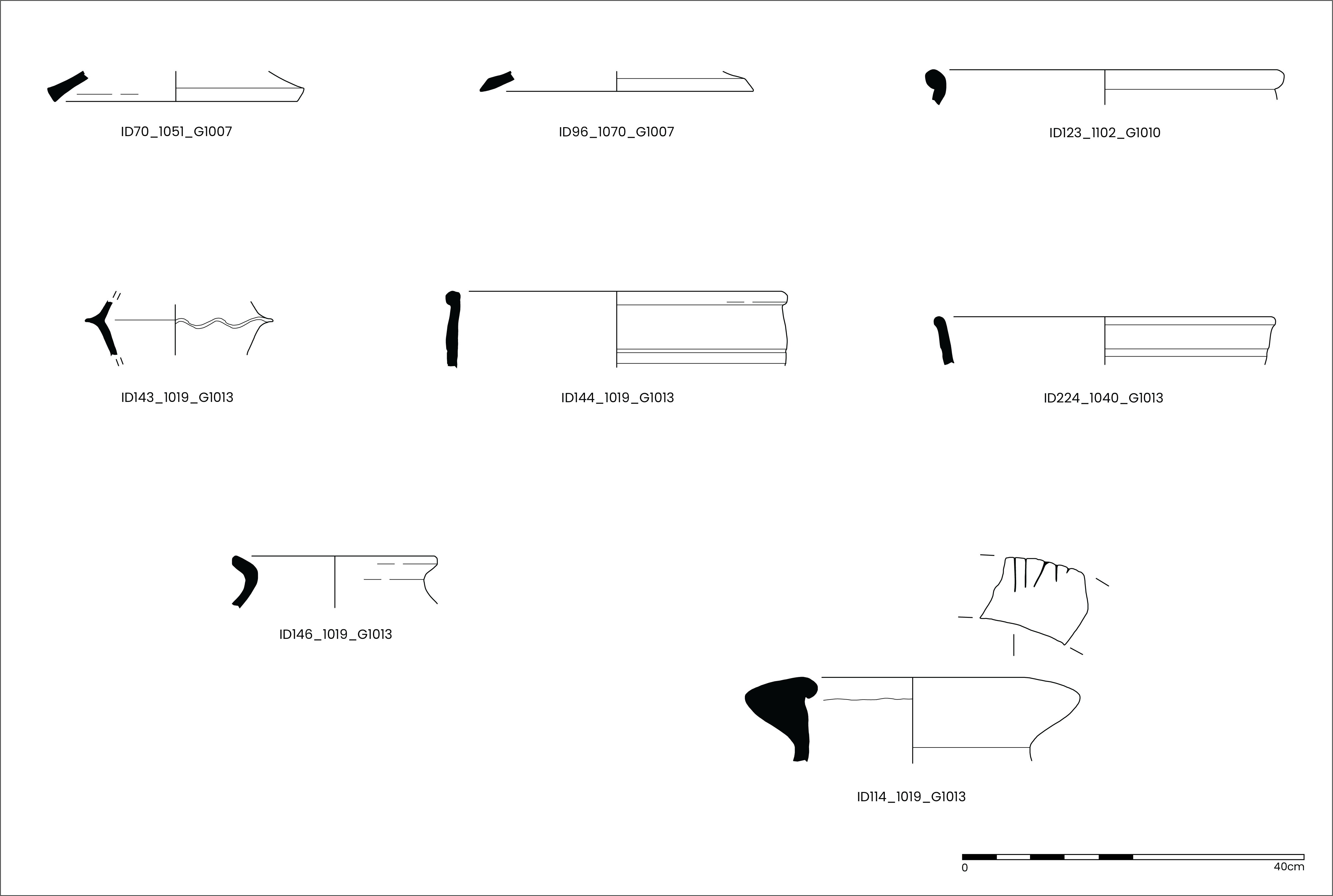
The remains of possibly four Dressel 20 amphorae had dateable features (rim and/or handle), two of which were recovered from Well Group 1001 (IDs 196 and 242, Figure 16), dating from the late 1st to early 2nd century CE. The remaining two were a handle fragment (ID105, c. 140 CE to the early 3rd century CE, Figure 17) recovered from Pit Group 1002, directly above the well deposit, and a rim fragment (ID114, c. 110 to 150 CE, Figure 18) from the fill of Ditch Group 1013. The amphora handle from Pit Group 1002 (ID105, Figure 17) was clearly stamped.
The stamp, which is complete and enclosed in a cartouche, reads Q ^AE O ? and is in ansa, reading from the summit of the handle downwards [the letters A and E are in ligature]. Unfortunately, the last letter cannot be read but it is likely to have been a P, with the stamp belonging to the firm of Q Ae( ) O(ptati) P(ortus). This pottery workshop for Dressel 20 amphorae has produced a variety of stamps based around the cognomen Portus (Callender 1965, no. 1416; Berni Millet 2008, 321). For example, the stamp Q AE O P O was found at Chester (Carreras and Funari 1998, no. 40). These stamps are associated with the large workshop of La Catria, situated on the south bank of the River Guadalquivir, opposite Axati (Berni Millet 2008, map VI). Dating is difficult, but the Chester stamp was dated by Testaccio levels to the reign of Hadrian (Carreras and Funari 1998, no. 40). A similar date may well apply to the York stamp, since it is in the distinctively gritty fabric that is common in Dressel 20 amphorae of the 1st and early 2nd centuries CE.
Two fragments of amphora had been modified in antiquity: a rim fragment from the fill of Ditch Group 1013 (ID114, c. 110 to 150 CE, Figure 16) had been inscribed post-production on the top with 'V II'; interestingly, another sherd, the remains of a decorated samian bowl (ID151) was recovered from the same deposit, which was also inscribed, possibly reading 'V II', perhaps linking the two vessels to the same person, establishment or activity. The second (potentially) modified amphora sherd was a large rim and neck fragment (ID242, Figure 16) of a Dressel 20 amphora, with parts of the body removed by 'chipping' at the edges with a sharp tool, to form a regular shape. This type of modification has been recorded elsewhere, where it has been suggested that the neck portions of amphora were reused, possibly as a funnel or pipe (Peña 2007, 148; section 6.12, funnel, and 180; section 6.26, drain). The fragment was found in Well Group 1001.
Fine wares
In total, 38 sherds of fine wares were recovered, which included 27 sherds of samian ware, a single small sherd (0.8g) of a Gaulish Colour-coated ware, six sherds of a fine, Ebor ware beaker, and four sherds of Lower Nene Valley Colour-coated ware (Table 1; Table 2).
The samian assemblage was small, consisting of 27 sherds from a maximum of 20 vessels (MNV = maximum number of vessels) (Table 2). Owing to the small size of the samian assemblage no 'stand-alone' analysis was undertaken and the data are integrated into the overall analysis for the pottery assemblage. There was no obvious concentration for the recovery of samian sherds, which were recovered from ten features across the site. The assemblage originated predominantly from two sources in South (La Graufesenque, LGF SA, Tomber and Dore 1998, 28) and Central Gaul, mostly Lezoux (LEZ SA, Tomber and Dore 1998, 30–1). Eight sherds bore decoration, six of which were from South Gaul (MNV=3) and two from Central Gaul (MNV=2). No sherds were stamped with a maker's mark. Vessel forms included: South Gaulish including a cup (Dr27), four bowls, including two Dr37, a bowl/dish, and three dishes with forms including Dr18 and Dr36; Central Gaulish forms included three bowls, including two Dr37, and two dishes, one of which was Dr18/31 or Dr31.
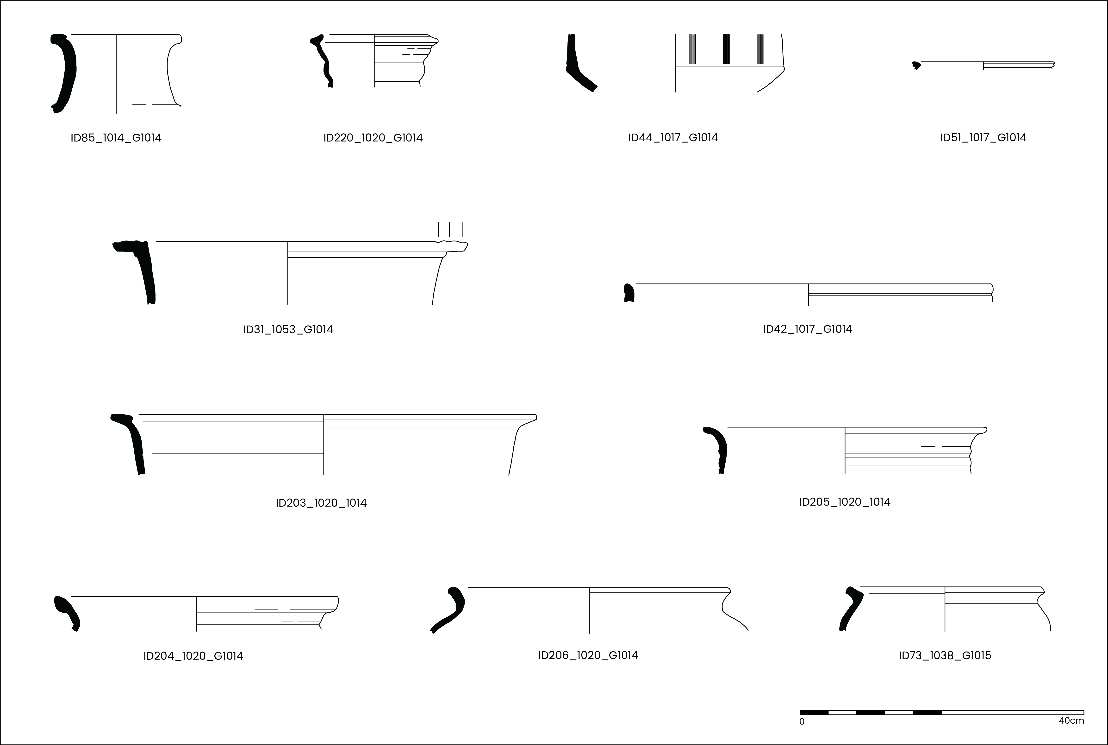
Other fine wares were present but in small quantities. A single small body sherd (0.8g) of a Gaulish fine colour-coated was recovered (ID80). Romano-British fine wares included four sherds in Lower Nene Valley Colour-coated wares, including the rim of a beaker (ID51) dating to the late 2nd to early 3rd century CE and three undiagnostic body sherds. There were six sherds of a fine, Ebor ware, oxidised beaker (ID192, Figure 16) dated to the 2nd century CE, with splashes/patches of white painted decoration, all recovered from Context 1111, the top fill of Well Group 1001.
Mortaria
Three sherds of mortaria, and three sherds of possible mortaria (in a North Gaulish fabric, which may also be of an amphora, see above), were recovered (Table 1; Table 2). These included two sherds produced in Lincolnshire (LTC WH, Tomber and Dore 1998, 160) during the 2nd century CE, and one sherd of Cantley White-slipped ware (CAN WS, Tomber and Dore 1998, 194), produced in South Yorkshire during the 3rd to 4th centuries CE.
Coarse wares
In total, 566 sherds of Roman period coarse wares were recovered (Table 1; Table 2). The bulk of the coarse wares consisted of reduced (greywares) and oxidised wares, many of which were consistent with Ebor products (Monaghan 1997, 869–80) and/or other regional wares. The forms identifiable were predominantly flagons and jars, with lower quantities of bowls and dishes. The high relative proportion of flagons was notable and is discussed further below.
Forty-three sherds of rusticated wares were also recovered, dating from the late 1st to early 2nd century CE. These included a near-complete jar (ID59, Figure 17) found in the fill of Ditch Group 1003 (as were other sherds in rusticated ware), dating to the early 2nd century CE. Small quantities of rusticated ware were also found in fills of Ditch Group 1007and Pit Group 1002 (directly above the Well Group 1001). Other rusticated ware forms were present in relatively low quantities, but included small jars/beakers, lids and two possible tazze body sherds (ID 143, Figure 18).
Two sherds that potentially represented head pots were also recovered; one small sherd (11.1g) could represent a head pot or beaker, while another sherd (ID137), possibly formed into an eyebrow, was recovered from Ditch Group 1013.
The bulk of the coarse wares had a relatively narrow date range, restricted to the 2nd century and into the early 3rd, with small quantities of late 1st to early 2nd century CE material (two legionary-style carinated bowls, a legionary-type jar, and an early 2nd-century CE rusticated ware jar). There were few sherds of mid- to late 3rd and/or 4th century CE pottery, although these included one sherd of a Cantley White-slipped mortarium (3rd to 4th century CE), an East Yorkshire Calcite-gritted ware jar rim (Swan 2002, mid/late 3rd to 4th century CE), a Holme-On-Spalding Moor carinated bowl (Creighton 1999, 3rd to 4th century CE), and a reduced ware lid-seated jar (type JV, Monaghan 1997, 989).
| Ware and Class | Count | % of count | Weight | % of weight | EVEs | % EVEs |
|---|---|---|---|---|---|---|
| North Gaulish White ware | 1 | 0.2% | 8.9 | 0.1% | 0.0% | |
| Amphorae/Mortaria | 3 | 0.5% | 10.5 | 0.1% | 0.0% | |
| North Gaulish | 3 | 0.5% | 10.5 | 0.1% | 0.0% | |
| Fine wares | 36 | 5.8% | 238.7 | 2.0% | 82 | 7.5% |
| South Gaulish samian | 14 | 2.2% | 163.2 | 1.4% | 21 | 1.9% |
| Central Gaulish samian | 12 | 1.9% | 42.3 | 0.4% | 18 | 1.7% |
| Gaulish? Colour-coated ware | 1 | 0.2% | 0.8 | 0.0% | 0.0% | |
| Lower Nene Valley Colour-coated ware | 3 | 0.5% | 23.6 | 0.2% | 7 | 0.6% |
| Oxidised ware/Ebor | 6 | 1.0% | 8.8 | 0.1% | 36 | 3.3% |
| Mortaria | 3 | 0.5% | 319.1 | 2.7% | 0.0% | |
| Cantley White-slipped ware | 1 | 0.2% | 39.2 | 0.3% | 0.0% | |
| Lincoln Technical College | 2 | 0.3% | 279.9 | 2.3% | 0.0% | |
| Coarse wares | 541 | 86.7% | 7023.1 | 58.6% | 892.5 | 81.9% |
| Oxidised ware | 7 | 1.1% | 99.8 | 0.8% | 10 | 0.9% |
| Oxidised ware/Ebor | 177 | 28.3% | 2213.7 | 18.6% | 77.5 | 7.1% |
| Oxidised ware/White-slipped Ebor | 105 | 16.8% | 1920.6 | 16.1% | 429 | 39.4% |
| Reduced ware | 106 | 17.0% | 1138 | 9.5% | 142.5 | 13.1% |
| Reduced ware/Ebor | 46 | 7.4% | 610.8 | 5.1% | 59 | 5.4% |
| Reduced ware/White-slipped Ebor | 5 | 0.8% | 16.4 | 0.1% | ||
| Reduced ware/Rusticated | 43 | 6.9% | 507.8 | 4.2% | 100 | 9.2% |
| Reduced ware/burnished reduced | 35 | 5.6% | 312.3 | 2.6% | 59.5 | 5.5% |
| Black-burnished ware | 12 | 1.9% | 184 | 1.5% | 12.5 | 1.1% |
| White ware | 1 | 0.2% | 2.6 | 0.0% | ||
| Derbyshire ware | 1 | 0.2% | 4 | 0.0% | 0.0% | |
| East Yorkshire Calcite-gritted ware | 1 | 0.2% | 7.2 | 0.1% | 1.5 | 0.1% |
| Grog-tempered ware | 2 | 0.3% | 5.9 | 0.0% | 1 | 0.1% |
| Grand Total | 624 | 100.0% | 11983.4 | 100.0% | 1090 | 100.0% |
The bulk of the Romano-British pottery, 624 sherds out of a total of 655, was recovered from deposits across the site associated stratigraphically with Phase 2 activity (Table 1; Table 2). While many of the features excavated contained relatively small quantities of pottery, there were larger assemblages recovered from certain deposits, especially Ditch Group 1003 (north-east/south-west aligned ditches, ditches in Groups 1013 and 1014 (central north-west/south-east aligned ditches, and the cask-lined well groups, Pit Group 1002 and Well Group 1001).
| Feature | Count | Weight (g) |
|---|---|---|
| Group 1001 Well | 129 | 4577.3 |
| Group 1002 Pit | 27 | 555.1 |
| Group 1003 Ditch | 122 | 2466.9 |
| Group 1005 Ditch | 27 | 241.2 |
| Group 1006 Ditch | 10 | 460.7 |
| Group 1007 Ditch | 35 | 197.3 |
| Group 1008 Ditch | 14 | 194.1 |
| Group 1009 Ditch | 5 | 37.4 |
| Group 1010 Ditch | 5 | 53.6 |
| Group 1012 Ditch | 1 | 39.7 |
| Group 1013 Ditch | 100 | 1569.9 |
| Group 1014 Ditch | 146 | 1561.2 |
| Group 1015 Ditch | 3 | 29 |
| Grand Total | 624 | 11983.4 |
Cask-lined well G1001 — 2nd century CE (c. 120 to 200 CE)
In total, 129 sherds were recovered from two fills of Well Group 1001; 108 sherds from upper fill (1111), and 21 sherds from lower fill (1114) (Table 3; Table 4). Both fills contained a similar range of material and there was no discernible chronological difference between the two. The assemblage included five sherds of Baetican amphorae, two of which had rims of late 1st to early 2nd century CE types (IDs 196 and 242,upper fill (1111), Figure 16). As noted above, the rim and neck fragment ID242 (Figure 16) showed evidence of tool marks around the base of the neck where it had been removed from the body, possibly to modify for reuse as a funnel or pipe/drain (e.g. Peña 2007, 148; section 6.12, funnel, and 180; section 6.26, drain). Two fine ware sherds were recovered from the upper fill of the well, including one small (1.5g) rim sherd of a South Gaulish samian ware dish (Dr36, c. 70 to 110 CE), and six sherds of a fine, thin-walled oxidised Ebor ware beaker (ID192, Figure 16, Monaghan Type KC4/5, 2nd century CE). Coarse wares formed the bulk of the assemblage from the well, with 117 sherds; most were fragments of oxidised and reduced white-slipped flagons (106 sherds, 429 EVEs), dating to the 2nd century CE, likely from approximately 120 CE (Figure 16). No other oxidised ware forms were present. This was a large quantity of flagons in one feature, possibly resulting from the vessels being broken in the process of decanting water from buckets into narrow-necked spouts, then knocked into the well accidentally. Other coarse wares included two sherds of black-burnished ware.
Pit Group 1002 — 2nd century CE (c. 120 to 200 CE)
In total, 27 sherds were recovered from two fills of Pit Group 1002 (18 sherds from upper fill (1106), and nine sherds from (1109), the lower fill (Table 3). The assemblage contained a range of material similar to that in the well deposits situated stratigraphically below. The assemblage included two sherds of amphorae, one each of Baetican and Gaulish types, and three small sherds (10.5g) of amphorae or mortaria of North Gaulish origin. The Baetican amphora was a handle fragment, stamped with a maker's mark (see above), dating from the late 1st to early 2nd century CE (ID105, Figure 17). Fine wares included two sherds from Central Gaul, one from a decorated Dr37 bowl (ID37, c. 120 to 200 CE), the other of uncertain form. Coarse wares were mostly oxidised white-slipped body sherds, likely parts of flagons, and oxidised ware body sherds. There was a small quantity of reduced wares, including a single sherd that may have been part of a head pot or indented jar/beaker (ID37), and two body sherds of rusticated types, dating from the late 1st to early 2nd century CE.
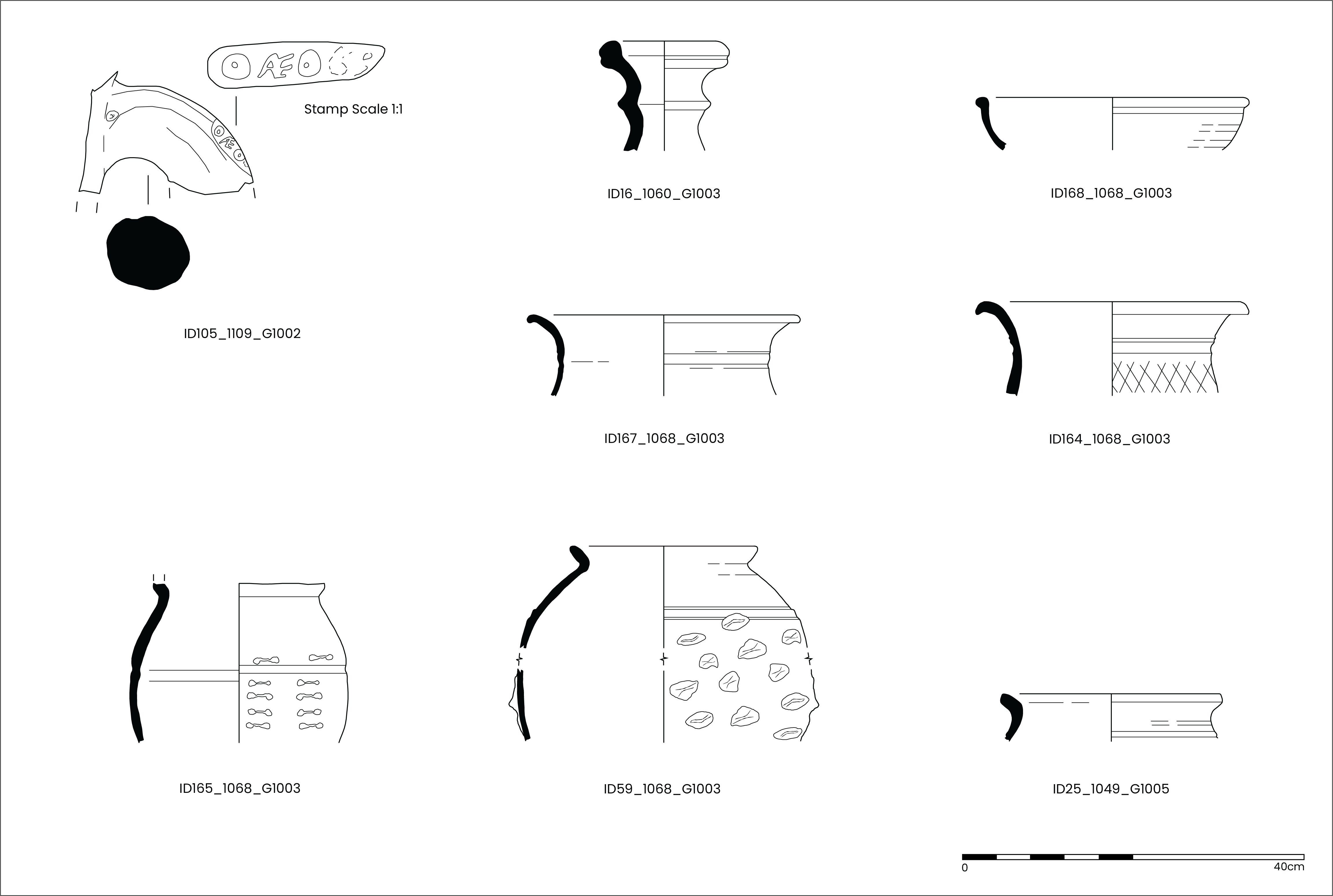
North-east/south-west aligned Ditch Group 1003 — 2nd century CE
In total, 122 sherds were recovered from two fills (1060) and (1068), in Ditch Group 1003. The assemblage included five sherds of probable Baetican amphorae body sherds, some of which were in a gritty fabric dating from the late 1st to early 2nd century CE. Fine wares consisted of five sherds of samian ware, all of South Gaulish origin and from a maximum of four vessels; vessel forms included a Dr26 cup (c. 70 to 110 CE), a Dr18 dish (c. 60 to 90 CE), and rim sherds of a bowl and a bowl/dish, both likely to date from the late 1st to early 2nd century CE. A single sherd of a Cantley white-slipped mortarium was recovered; the vessel had slag trituration grits and dates to the 3rd to 4th century CE, probably the early 3rd century CE given the other pottery recovered. In total, 111 sherds of coarse wares were recovered from the two ditch fills, predominantly in Ebor fabrics, oxidised wares and reduced wares. Vessel forms in oxidised wares were mostly flagons of late 1st to 2nd century CE date and a single small hemispherical bowl. Vessel forms in reduced wares included a poppyhead-type beaker of 2nd to early 3rd century CE date, a pulley-wheel flagon (Monaghan 1997, 979, type FP) of 2nd century CE date, a narrow-necked jar/flagon, and the remains of four jars, three of which were rusticated types of late 1st to early 2nd century CE, one of which (ID59, Figure 17) was almost complete with 'star' rusticated decoration.
Central north-west/south-east aligned ditches, Ditch Groups 1013 and 1014
Ditch Group 1013 — 2nd century CE
The assemblage included 13 sherds (981.8g) of Baetican amphorae, 10 of which joined and were part of the rim and neck of a vessel, dating to the first half of the 2nd century CE (ID114, Figure 18). The vessel had been inscribed on the top of the rim with 'V I I' (Figure 18). Fine wares consisted entirely of samian ware, with three sherds of South Gaulish and four sherds of Central Gaulish origin; the three South Gaulish sherds were the base and body of a decorated bowl (ID151) dating from the late 1st to early 2nd century CE, and the four sherds of Central Gaulish material included the rim of a dish, a body sherd of uncertain form, and two 'chips', all dating to the 2nd century CE. The outer body of the South Gaulish decorated bowl (ID151) is inscribed on the lower half of the outside of the body, possibly reading ' V I I'; this inscription was of particular interest given that that it was found in the same deposit as the amphora rim (ID114, Figure 18) also inscribed with 'V I I'. These may have been tally marks, and/or related to activity (possibly a roadside inn?). In total, 80 sherds of coarse wares were recovered from Ditch Group 1013, predominantly oxidised (60 sherds) and reduced (16 sherds) wares, most of which were in Ebor fabrics. While most of the assemblage comprised body sherds, vessel forms present in oxidised wares included a hemispherical bowl (120 to 200 CE), a body sherd of a tazze or flanged bowl (2nd century CE), and a small fragment of a head pot, possibly part of an eyebrow (ID137). Reduced ware forms present were mostly jars, along with a hemispherical bowl (late 1st to 2nd century CE). Other coarse wares present included a small sherd (2.6g) in a white ware fabric, a sherd of black-burnished-type ware 2, and two sherds of a jar in a grog-tempered ware.
In addition, six sherds of medieval pottery were recovered from Context 1019 in Ditch Group 1013 and were considered intrusive.
Ditch Group 1014 — late 2nd to 3rd century CE
The assemblage from Ditch Group 1014 included six body sherds of amphorae, of which four were of Baetican origin and one small sherd (3.1g) was from elsewhere in Southern Spain; one sherd (8.9g) was of North Gaulish origin, which may be part of either an amphora or a flagon. Fine wares consisted of single sherds each of South Gaulish samian ware (late 1st to early 2nd century CE), a Gaulish colour-coated ware beaker (one sherd weighing 0.8g), and a Lower Nene Valley Colour-coated ware cornice rim beaker (ID51, Figure 19), dating from the late 2nd to early 3rd century CE. A single sherd of a mortarium was recovered, made in Lincoln during the 2nd century CE. The bulk of the assemblage was made up of coarse wares, a total of 136 sherds. The coarse wares were predominantly reduced (80 sherds) and oxidised wares (48 sherds), most of which were in Ebor fabrics. Vessel forms in oxidised wares were mostly flagon rims, necks and handles (broadly 2nd century CE), and three bowls, including a late 1st to early 2nd century CE reeded rim, legionary-style carinated bowl (ID31), a hemispherical bowl (ID42, Figure 19) of 2nd century CE date and the third was a deep bowl type. Reduced ware forms were predominantly jars, including types of 2nd to 3rd century CE date (Monaghan types JE, JM, JN, and possibly JV, and therefore dating from the late 3rd to 4th century CE). Other coarse ware forms included two beakers and one beaker/small jar, similar in type to Leary's JC9A (2021, appendix I, 64, mid-2nd to 3rd century CE). The remains of two carinated bowls were also recovered, one of Monaghan type BD (ID203, Figure 19) of 2nd century CE date, and one of East Yorkshire origin of Creighton type B04 (1999, 148) dating from the beginning of the 3rd century CE (ID44, Figure 19). There was also a body sherd (6.5g) of a possible reduced ware tazze or flanged bowl. Other coarse wares included: six body sherds of black-burnished wares; three sherds each of black-burnished ware 1-type and 2-type; a single body sherd of Derbyshire ware dating from approximately the middle of the 2nd to the 4th century CE; and a single rim sherd of a jar in East Yorkshire Calcite-gritted ware dating from the middle of the 3rd century CE (note: this may have been intrusive given the generally 2nd century CE date range).
A single sherd (0.7g) of medieval pottery was recovered and was considered intrusive.
Functional analysis was undertaken (Table 4) with phase/chronological and feature results compared with sites in York: for fortress and waterfront areas, Guildhall (Griffiths 2024, 339, table 11), Blake Street (Monaghan 1993, 696, table 106), and Swinegate/Back Swinegate (Monaghan 1997, 856, table 135); for colonia, 1–9 Micklegate (Monaghan 1997, 856, table 134); Region 4, 35–41 Blossom Street (Monaghan 1997, 857, table 136); and extramural sites Peasholme Green (Monaghan 1997, 857, table 137), 21–33 Aldwark (Monaghan 1997, 857, table 138), and 16–22 Coppergate (Monaghan 1997, 858, table 139). While the assemblage from Regency Mews was considered of suitable size for statistical analysis, there are two aspects to highlight that may influence the results presented here.
| Form | All pottery (Phase 2) | Well/Pit removed | Well/Pit only |
|---|---|---|---|
| Cup | 0.8% | 1.7% | |
| Beaker | 4.6% | 1.5% | 7.7% |
| Small jar/Beaker | 1.1% | 2.2% | |
| Flagon | 53.3% | 15.8% | 91.6% |
| Flagon/NNJ | 3.7% | 7.3% | |
| Jar/deep bowl | 25.2% | 49.9% | |
| Bowl | 6.3% | 12.5% | 0.0% |
| Dish | 2.7% | 4.7% | 0.7% |
| Bowl/Dish | 0.4% | 0.8% | |
| Tazze/bowl? | 0.0% | 0.0% | |
| Lid | 1.8% | 3.6% | |
| Mortarium | 0.0% | 0.0% | |
| Head pot | 0.0% | 0.0% | |
| Head pot/jar | 0.0% | 0.0% | |
| Grand Total | 100.0% | 100.0% | 100.0% |
The overall assemblage
Firstly, of the 624 sherds of Romano-British pottery from stratigraphically secure Phase 2 deposits, 468 were from ditches, which often did not contain primary deposits (most of these sherds were from Ditch Groups 1003 (122 sherds), 1013 (100 sherds), and 1014 (146 sherds)). Secondly, 156 sherds were recovered from the cask-lined well (Well Group 1001) and the pit directly above the well (Pit Group 1002); the assemblage from these deposits was likely not from regular rubbish disposal and/or subjected to long-term post-depositional disturbance, but probably accidental loss into the well where it lay relatively undisturbed until excavation. Both these factors have the potential to influence the results of analysis and as such are presented separately in Table 4. The average sherd weight of pottery recovered from features that contained more than 100 sherds was considered, with the figure for Well Group 1001 deposits being the highest at 35.5g, compared with 20.2g for Ditch Group1003, 14.9g for Ditch Group 1013, and 10.7g for Ditch Group 1014 (Table 3). Table 4 presents the relative proportions by form for the pottery considered in this report.
All contexts excluding the Well/Pit Groups 1001 and 1002
The results for the functional composition of the pottery from all of the non-well/pit deposits show that jars (including deep bowls/jars) form the largest proportion at 49.9%, with lower levels of flagons (23.1%), and 18% of bowls/dishes. Cups and beakers formed small proportions, at 1.7% and 3.7% respectively; lids formed 3.6% of the assemblage.
The relative proportions of drinking vessels, i.e. cups and beakers, formed 5.4% of the non-well/pit assemblage, slightly greater than Swinegate, Period 4 (2%), Guildhall, Period 3 (4.1%), comparable with 35–41 Blossom Street, Period 2 (5.3%) and 16-22 Coppergate, Period 1/3 (5.4%). It is lower than Peasholme Green, Period 1 (8.5%), Guildhall, Period 2 (11.0%), and 1-9 Micklegate, Periods 1 (11.0%) and 2 (8.9%).
The relative proportions of vessel types for dining, i.e. bowls and dishes, was 18.0%; this figure was lower than at all other sites considered here of similar date. The figure was most closely comparable with Period 3 at Blake Street (21%), Period 1 at 1-9 Micklegate (23%), Period 1 at Peasholme Green (22.1%), and Period 1 at Guildhall (23.4%).
Flagons/narrow-necked jars, for pouring and serving liquids, formed 23.1% of the non-well/pit assemblage. This proportion was greater than at Blake Street (Period 3, 12%, and Period 4, 15%), 1–9 Micklegate (Period 2, 15%), Blossom Street (Period 1, 18%, and Period 2, 16%), 16–22 Coppergate (Period 1/3, 15%), and Guildhall (Period 2, 16.4%). However, the relative proportions of flagons from Regency Mews was lower than Period 1 at 1–9 Micklegate (29.0%), Period 3, Swinegate (36%), Period 1 at Peasholme Green (33%), and Period 3 at Guildhall (33.9%).
The relative proportion of jars at Regency Mews formed 49.9% of the assemblage, a relatively high figure for the 2nd century at York, but comparable with Period 3 at Blake Street (46%) and Period 3 at Swinegate (42%). The figure was greater than for Period 4 at Blake Street (35%), Periods 1 (35%) and 2 (19%) at 1–9 Micklegate, Period 4 at Swinegate (21%), Periods 1 (32%) and 2 (33%) at Blossom Street, Period 1 at Peasholme Green (20%), Periods 1 (11%) and 2 (28%) at Aldwark, Period 1/3 at Coppergate (34%), and Periods 1 (31.7%), 2 (20.3%) and 3 (23.0%) at Guildhall.
There were very low levels of mortaria, with a maximum of just six sherds (as discussed, three could represent amphorae), none of which were rims. This was very low compared with almost all periods from all sites of a similar period considered in this report. Other vessel types, such as lids and head pots, were present in low numbers.
The Well/Pit Groups 1001 and 1002
This group of material was probably a primary deposit and subjected to limited post-depositional disturbance. There was a very high level of flagons, some 91.6%, which perhaps should not be surprising given the function of the well. However, it is not always practicable to fill a flagon, a vessel with a narrow neck and spout, directly from a well, without being able to hold the spout firmly under the water. More likely, the flagons were receptacles for water decanted from a bucket or a jar, and were broken as part of this process, and deposited in the well through accidental loss or discard. Beakers (7.7%) and a dish (0.7%) made up the remainder of the well/pit ceramic assemblage.
The assemblage was analysed as a single stratigraphic phase (Phase 2). Activity in this phase at the site dates broadly to the 2nd century CE, with small quantities of late 1st to early 2nd century CE pottery, and some later 2nd and 3rd century CE material, spread across the site but mostly from Ditch Group 1014. The pottery assemblage consisted of local, regional and nationally distributed wares, as well as continental imports (Table 2). There were two body sherds of prehistoric-tradition pottery, likely to have been produced in the region and possibly dating from the Iron Age and/or Romano-British periods. As expected for a Romano-British site close to the major Roman military and civilian centre at York, imported pottery was present and included transport amphorae from Baetica and other parts of southern Spain, mostly for shipping olive oil to Britain; one or possibly two sherds of Gaulish amphora were present, originally used to transport wine to the province. Other imported pottery consisted almost entirely of samian ware, from both South Gaul (La Graufesenque, late 1st to early 2nd century CE), and Central Gaulish production centres (Lezoux, 2nd century CE). Nonetheless, a single small sherd (0.8g) of a Gaulish colour-coated ware beaker was also present. Nationally traded products were relatively few, consisting of three sherds of Lower Nene Valley colour-coated ware, and two sherds of black-burnished ware 1 from Dorset (DOR BB1, Tomber and Dore 1998, 127); additional black-burnished wares of unknown source were also present. Other material from outside of York came from Derbyshire (one sherd), Lincolnshire (two sherds of mortaria), South Yorkshire, including a Cantley white-slipped ware mortarium and likely some of the reduced wares, and East Yorkshire/Humberside including a single sherd of East Yorkshire calcite-gritted ware, and reduced wares from the kilns at Holme-On-Spalding Moor (HSM RE, Tomber and Dore 1998). However, the bulk of the pottery was produced in the York area and consisted of Ebor oxidised and reduced wares, including large quantities of white-slipped ware flagons. The date range of the pottery was relatively restricted to the 2nd century CE; therefore, the later dating types common in York and the region were absent (e.g. Crambeck wares and Huntcliff-type jars).
While the assemblage was relatively small, there were key groups of sherds recovered from certain features across the site (see above). The pottery recovered from the well/pit (Well Group 1001 and Pit Group 1002) was of particular interest, consisting of relatively large quantities and proportions of Ebor white-slipped ware flagons of limited date range. There was a relatively high relative proportion of flagons recovered from the site, even when the data bias of the well/pit group assemblage was considered (Table 4).
There was evidence for the modification and reuse of an amphora neck recovered from the well (ID242, Figure 16), possibly as a pipe/drain or funnel. An amphora handle fragment bore the maker's stamp, and is discussed above. In addition, the rim of Baetican amphorae (ID114, Figure 18) was inscribed with Roman numerals 'V I I'; a decorated samian ware bowl (ID151) was recovered from the same deposit and was also inscribed with possibly 'V I I' on the outer body of the vessel.
The study of the Romano-British pottery from Regency Mews provides insights into many aspects of daily life during the 2nd century CE, where inhabitants lived and worked near the main southern approach road, designated as Road 10 by the RCHME (RCHME 1962, 3), one of the major routes into the Roman city in the environs of York. The status and function of the site is difficult to discern, with relatively small quantities of fine table wares, and a limited range of imported commodities (it should be noted that some or all of the amphorae may have been reused for storage or other functions (e.g., the modified amphora neck, ID242, Figure 16). The relatively small proportions of drinking vessels and high-status fine wares do not suggest a military function, perhaps not surprising when most of the military were based in York's legionary fortress. The relatively high proportion of flagons was biased by the well/pit groups; however, even when these were removed from the data (Table 4), the figures were still high. When considered alongside the relative proportion of jars, and very small proportions of mortaria and vessels with evidence for cooking, it was difficult to infer site function and status, but the range and proportions of vessels may represent something other than domestic activity; the putative mansio at the neighbouring 42–50 Tadcaster Road (McComish 2004, 20) being a likely candidate and certainly one where lots of water was required and whose occupants and visitors might have made regular use of the well.
Through the analysis of Roman pottery, one may start to visualise activity at the site. The well-side decanting of water into flagons that so often were lost or broken in the process must have been a constant source of frustration, but this gives an insight into the absolutely critical activity of supplying water to people living at and visiting the site. We can visualise the dinner table, activities surrounding the providing of drinks and food, the contents of storage vessels on shelves and in cupboards, and people eating and drinking from cups, beakers and bowls. Not only do the pots provide insights into Roman daily life, but they are the chronological indicators that underpin the dating for Roman activity at most archaeological sites of this period, as is the case at Regency Mews.
Following the assessment of 13 environmental samples (Adams 2022), three samples were selected for analysis of the waterlogged plant macrofossils and two for charcoal (Table 5; Table 6). The waterlogged plant macrofossils derive from Roman activity from fills of Well Group 1001 (sample <21> from the lower fill; samples <18> and <19> from the upper fill), and the charcoal from ditch fill (1068) in Ditch Group 1003 (samples <9> and <10>). The following report discusses the preservation of the waterlogged plant macrofossils and charcoal and their ability to inform on the diet, arable economy and local environment of the site as well as fuel selection and use.
Waterlogged plant macrofossils
The waterlogged plants across the assemblage ranged in preservation from poorly preserved to moderately well preserved.
The sample <21> from the lower part of the Roman well, fill (1114), contained the widest taxonomic range and density of waterlogged plant remains per litre of the three samples. It included a range of edible plant remains such as bramble (Rubus fructicosus), raspberry (Rubus idaeus), elder (Sambucus nigra), hawthorn (Crataegus monogyna) and two hazelnut shell fragments (Corylus avellana). This sample also contained a range of wild plants common to arable or disturbed ground. These included nettle (Urtica dioca), fat hen (Chenopodium album), violet (Viola L.), Hemlock (Coninum maculatum), thistles (Cirsium arvense), and hemp thistle (Eupatroprium cannabinum). Additionally, a moderate range of plants also common to wet and wooded environs were present. These included a large number of red campion (Silene dioca), along with a couple of blackthorn (Prunus spinosa), cherry plum (Prunus cerasifera), sedge (Carex sp.), knotweed (Persicaria sp.), and meadow buttercup (Ranunculus acris) and creeping buttercup (Ranunculus repens).
The samples from (1111), the upper fill of this well (samples <18> and <19>), included several of the same species as the lower part of the fill. However, far fewer plant macrofossils were present. The only inclusion unique to sample <19> was the sedge lenticular. Unlike the lower fill, neither sample <18> or <19> contained any plants indicative or arable or disturbed ground.
|
Preservation: + = poor ++ = moderate +++ = good |
Feature | Well [1110] | ||
|---|---|---|---|---|
| Sample Number | <19> | <18> | <21> | |
| Context | (1111) | (1111) | (1114) | |
| Context Description | Well | Well | Well | |
| Sample Volume (L) | 2.5 | 38 | 48 | |
| Preservation | + | ++ | ++ | |
| Number of Individuals per Litre | 2 | 1 | 4 | |
| Taxonomic Identification | English Name | |||
| Edible Plants | ||||
| Corylus avellana L. | Hazelnut shell fragment | 1 | - | 2 |
| Rubus fruticosus L. | Bramble | 1 | 7 | 25 |
| Rubus idaeus L. | Raspberry | - | 5 | 14 |
| Sambucus nigra L. | Elder | 2 | 22 | 19 |
| Crataegus monogyna L. | Hawthorn | - | - | 2 |
| Wild Plants on Arable/Disturbed Ground | ||||
| Urtica dioica L. | Common nettle | - | - | 3 |
| Chenopodium album L. | Fat hen | - | - | 10 |
| Viola sp. L. | Violet | - | - | 1 |
| Conium maculatum L. | Hemlock | - | - | 1 |
| Cirsiumarvense L. | Thistles | - | - | 3 |
| Eupatroprium cannabinum L. | Hemp thistle | - | - | 2 |
| Wild Plants Common to Wet Environs | ||||
| Ranunculus repens L. | Creeping buttercup | - | - | 9 |
| Ranunculus acris L. | Meadow buttercup | - | 4 | 3 |
| Persicaria sp. L. | Knotweed | - | - | 1 |
| Carex spp. | Sedge lenticular | 1 | - | - |
| Sedge triangular | - | 1 | 2 | |
| Wild Plants in Wooded Environs | - | - | ||
| Silene dioica (L.) Clairv. | Red campion | 1 | 2 | 48 |
| Prunus spinosa | Blackthorn | - | 1 | 1 |
| Prunus cerasifera | Cherry plum | - | - | 3 |
| Prunus sp. | Cherries/Sloe/Blackthorn stone fragments | - | - | 2 |
| Indeterminate | ||||
| Indet. | Indeterminate weed seed | - | - | 2 |
| Indeterminate bud | - | 2 | 2 | |
| Total Waterlogged Plant Macrofossils | 6 | 44 | 153 | |
Charcoal
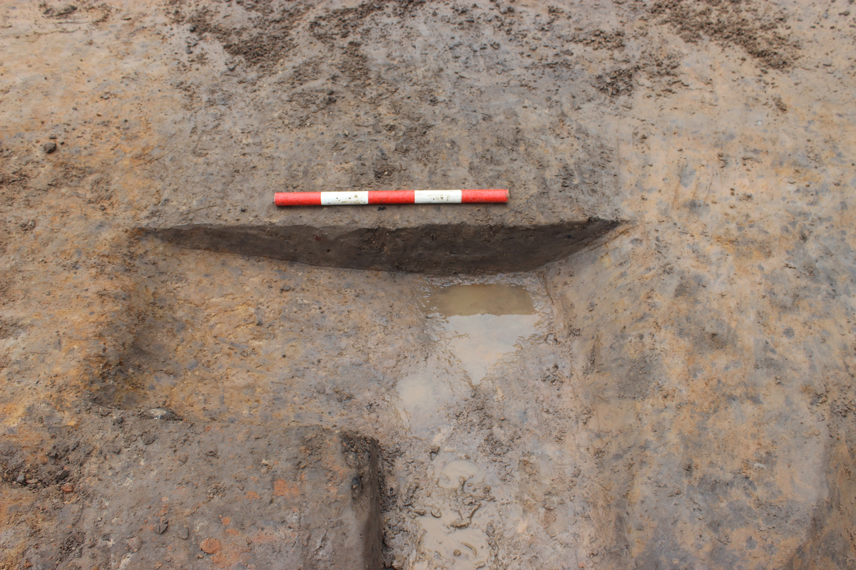
Preservation of the charcoal submitted for analysis from Regency Mews was moderate, with the majority of fragments identifiable to genus or species-level. The fragments were highly affected by post-depositional sediment, associated with fluctuating water tables after burial. Radial cracks were frequent in a charcoal deposit within fill (1067) of ditch cut [1067], Ditch Group 1003, while the charcoal in (1068), the main fill of ditch [1067], was affected by vitrification. Radial cracks appear as blown-up ray cells causing cracks of missing or exploded tissue. They indicate the presence of moisture in the wood and thus possibly reflect the burning of fresh wood (Fiorentino and D'Oronzo 2010). Vitrification is a feature often attributed to high temperatures and prolonged burning times (Gale and Cutler 2000; Prior and Alvin 1983), although contrasting experiments claim that it is not induced by such factors and that the cause is still unknown (McParland et al. 2010).
The composition of the two charcoal deposits from ditch [1067] at Regency Mews was largely similar, with oak (Quercus sp.) as the dominant taxon, accompanied by wood of the apple sub-family (Maloideae) and plum-type (Prunus sp.). Hazel (Corylus avellana) was recorded in the deposit by the vessel spot find while poplar/willow (Populus/Salix) and ash (Fraxinus excelsior) were present in the predominant fill of ditch [1067]. Indeterminate root and knotwood were identified in both deposits along with bark fragments in the fill of the ditch.
|
Preservation: + = poor ++ = moderate +++ = good Key: rw = roundwood |
Quercus sp. L. | Corylus avellanaL. | Populus/Salix | Maloideae | Prunus sp. L. | Fraxinus excelsior L. | Indet. | Indet. knotwood | Indet. root | Indet. Bark | |||||||
| Sample Number | Context Number | Context Description | Preservation | Average Ring Number per Wood Fragment | Oak | Hazel | Poplar/Willow | Apple sub-family; hawthorn, whitebeam, rowan, apple, pear | Plum-type; plums, cherries | Ash | Indeterminate | Indeterminate Knotwood | Indeterminate rootwood | Indeterminate Bark Fragment | Radial Cracks | Post-Depositional Sediment | Vitrified |
| <9> | (1068) | Spot find near vessel in Ditch [1067] | ++ | 2 | 67 rw:2 | 1 | - | 6 | 19 rw:1 | - | 1 | 5 | 1 | - | 16 | 48 | - |
| <10> | (1068) | Ditch [1067] | ++ | 3 | 70 | - | 2 | 10 | 2 rw:1 | 1 | - | 9 | 3 | 3 | - | 30 | 12 |
Waterlogged plant macrofossils
The waterlogged plant assemblage from Well Group 1001 tentatively suggests that the environment in the vicinity was ruderal, shrubby ground with hedgerows. Several of the plants in the lower part of the well's fill suggest disturbed ground, although such plants were absent from the upper fill. Even so, across the samples a number of wild plants were present, the sedges in particular, that prefer wet or damp conditions, for which the well would have provided the ideal environment.
Several edible plants are represented in the waterlogged assemblage from the well and could have potentially been exploited as food. Hazelnut and berries could have been opportunistically foraged to supplement the diet of individuals who found themselves in the vicinity of the well. Hawthorn may be included in the group of edible plants as well. The leaves of hawthorn are edible and there is some evidence from mainland Europe to suggest the haws were collected as food (Taylor 1981, 49). Furthermore, the waterlogged remains of several of the edible plants represented in this assemblage were recovered at several other sites in Roman York, including another Roman well at Bedern (Carrott et al. 1995; Hall and Kenward 1982; 1990; Kenward et al. 1986; Tomlinson 1989). However, it is difficult to say for certain whether the waterlogged, edible plant assemblage from the well specifically represents the remains of plants that were consumed as food. Firstly, a low-status, opportunistically foraged diet would exploit the surrounding edible plants in the environment in which an individual found themselves. As such, it would be difficult to distinguish foraged nuts and berries from organic detritus from the surrounding environment that accumulated at the base of the well over the course of its use. Secondly, the urban Roman deposits, such as the Bedern well, included a greater range of more exotic plants that were mainly exploited as foods and seasonings. Therefore, the basis of their interpretation as representing consumed foods is firmer than the edible plants recovered from the well at Regency Mews.
Charcoal
The charcoal assemblage at Regency Mews indicates that fuel was exploited from shrubby oak woodland with trees of the apple sub-family, plum-type and hazel likely extracted from the same woodland. The small number of roundwood fragments, from small branches and twigs, suggests that wood for fuel was harvested from large branches or trunk wood, potentially within a managed woodland to ensure a steady supply. The radial cracks, particularly high within the fragments of oak, imply that the wood was burnt while still fresh or damp rather than being properly dried out prior to use. Poplar/willow would have thrived along the banks of the River Ouse, while ash would have been present in light, open areas. The high frequency of post-depositional sediment within the fragments indicates frequent fluctuations in the water table after burial. A similar deposit was identified in Roman dumps at the North Annexe, York Guildhall site (Adams 2024, 164–5) with oak, ash, hazel and wood of the apple sub-family and plum-type present. The similarity in the deposits suggests comparable fuel supply and burning activities between the two contemporary sites, with wood likely selected and harvested for its fuel-burning properties rather than opportunistically collected from the local area.
The waterlogged plant remains and wood charcoal both make some contribution to better understanding the environment in the vicinity of this site during the Roman period and the wood fuel economy of Eboracum and its hinterland. The waterlogged plant remains from the well suggest that the environment in the immediate vicinity of this well during the Roman period was shrubby, ruderal, with some possible hedgerows, and at least in the case of the lower fill, suggested disturbed ground. While a number of the plants represented in the samples from this well were indeed edible, it is not clear whether they represent a low-status, opportunistically foraged diet or simply an accumulation of organic detritus from plants that grew in the vicinity of the well during the Roman period.
The similarities between the wood charcoal from this site, and that from the Guildhall, tentatively suggest that the supply of wood fuel within Roman Eboracum and its environs was subject to a certain level of organisation and management. As was the case with the Guildhall, the main wood fuel was oak and this was supplemented by other trees from riverine and shrubby environments. The prevalence of wood from large branch or trunk wood indicates that it was probably harvested from a potentially managed shrubby oak woodland. The fuel wood appears to have been burnt soon after harvesting, or while damp, rather than being properly dried out prior to use.
This pollen analysis focuses on two samples extracted from the lower fill (1114), and upper fill (1111) of the timber-lined Well Group 1001. A previous pollen assessment (Batchelor 2022) indicated a sufficiently high concentration and preservation of pollen in these samples for the pollen analysis reported below. The aim of this analysis was to provide further quantitative insights into the vegetation communities surrounding the site during the infill of the well, and for human activities, economy and diet.
There was a moderate to high concentration of pollen (320,000 to 420,000 grains/cm3) in a moderate state of preservation. The range of taxa in the assemblage is also very similar between samples. Herbaceous and shrub taxa tend to dominate, including heather (Calluna vulgaris; 6-16%), hazel (Corylus type; 16%), dandelion (Lactuceae; 8–15%), grasses (Poaceae; 8-19%) and pinks (Caryophyllaceae; 6%), with mugwort (Artemisia), daisies (Asteraceae), black knapweed (Centaurea nigra), fat hen (Chenopodium album), sedges (Cyperaceae) and buttercups (Ranunculus type) in both samples (all <3%). Trace values of heaths (Erica spp.), willow (Salix), cereals (Cereale type) and brassica (Sinapis type) were recorded in the sample from upper well fill (1111), while knotgrass (Polygonum aviculare), cinquefoil (Potentilla type) and clover/vetch (Trifolium/Vicia) were only recorded in the sample from the lower fill (1114) (all <1%). Tree pollen included alder (Alnus), oak (Quercus), pine (Pinus), and lime (Tilia); the lime grains being more poorly preserved, perhaps suggesting their reworking. Trace values of birch (Betula) and elm (Ulmus) were also recorded in both samples, with a single occurrence of probable ash (Fraxinus) in (1111). Spores of polypody (Polypodium vulgare), ferns (Filicales), bracken (Pteridium aquilinum) and moss (Sphagnum) were also recorded. Whipworm eggs were noted and microcharcoal was present in moderate or abundant concentrations in both samples. Unknown and unidentifiable grains were recorded in both samples.
The Roman well investigated represents a small depositional basin, and thus will have had a correspondingly small pollen source area, reflecting predominantly the vegetation of the immediate locality of the site. It is also likely that the pollen and spores within the well offer a variety of perspectives on the site, ranging from the types of material leading to its backfill (e.g. waste), to the character of the local farming regimes and the nature of the wider landscape.
The ratio of trees/shrubs to herbs is indicative of open environment, while the herbaceous assemblage itself is generally suggestive of disturbed ground and grassland communities growing locally. Woodland appears to be relatively limited and potentially managed, perhaps growing at a distance or in small stands close to the site, including hazel, oak, pine, lime, birch and elm. The lime pollen is often more poorly preserved than other grains in the assemblage, perhaps suggesting that they originate from older, reworked sediment that became integrated into the fill of the well. Alder is also recorded in both samples, which together with willow, sedges and potentially other herbaceous taxa are suggestive of damp conditions adjacent or nearby to the well.
Heather and moss were also frequently recorded in both samples, together with trace values from heaths indicating a significant local presence of heathland vegetation. However, it is also possible that heather and heaths were brought to the site for (for example) thatch, animal fodder or bedding, while Sphagnum moss, valued for its absorbent and antibacterial properties, may have been used for medical or sanitary purposes.
Cereal taxa are only recorded in upper Context 1111 and these are limited to three grains of what could potentially be wheat (Triticum sp.) or barley (Hordeum sp.) on the basis of caryopses recorded during the charred plant macrofossil assessment (Adams 2022). Comparable to the charred macrofossil assessment, these results do not indicate large-scale crop growth or cereal processing, and more likely represent domestic discard. Trichuris eggs were present in the sample from (1111) but it was not possible to confidently distinguish if they were from the species that infects people or pigs. Nevertheless, the presence of these remains would appear to indicate that cess and/or animal manure entered the well at least occasionally.
Other plant groups represented in the pollen record that may originate from food use include the brassica (which also includes water-cress, mustard and radishes) and vetch (which could include legumes, such as peas and beans). These were, however, present only at low frequency and might equally represent weedy taxa rather than crops, as individual species/genera within these families have very similar pollen grains.
The wood had been preserved in waterlogged anaerobic conditions and it appears that these conditions were maintained up until exposure during excavation. Most of the material was in fair condition, with some surface abrasion and occasional areas inadvertently damaged during initial exposure. The upper end of the cask staves had been lost to erosion with a sharp cut off at the top of the local water table, indicating a historically stable depth to this water table with little indication of significant fluctuation.
All of the wood appears to be associated with a well or pit, lined using a recycled cask. The technology, wood species and the associated finds all point to a Roman date. Board fragments and pieces of roundwood were also recovered from the fill of the feature, and represent pieces of wood caught up in the backfilling once the feature had been decommissioned. It was initially thought that the radially faced boards might have been parts of cask staves displaced from higher in the feature but these fragments are Quercus spp., which was not used in the construction of the cask as found.
Four of the five wood species present are native to the British Isles and there is no necessity for any of these three species to have been imported over any great distance. Nonetheless, the cask is made from staves cut from Abies alba Mill. - Silver Fir, a species not introduced as a growing tree to the British Isles until the post-medieval period. Silver Fir is a relatively well-known species from Roman-era deposits in Britain, where it is usually found as parts of finished coopered vessels. Indeed, many of the small wooden objects of Roman date made from this species are likely to have been made from recycled components of such a cask. This cask is therefore an imported item from continental Europe, specifically one of the North-west provinces of the Roman Empire.
The cask was constructed using standard methods of Roman cask technology. The staves are all cut from radially faced heartwood, though two are close to tangential conversions. While generally straight grains, there are some irregularities present that result from the incorporation of knots. There are no saw marks that would indicate sawn conversion - all appear to have been cleft from the parent log(s). Relict areas from this process where the cleft surface was not later trimmed away are present on one stave. Axe marks are present running diagonally across the axis of the staves where the surfaces have been dressed, marks indicating an axe with a blade width of more than 150mm was used. These marks are not contiguous across neighbouring staves and must therefore relate to dressing and finishing before the staves were put together to form the cask and clearly pre-date the cutting of the howel (see below), which truncates many of the axe marks. Faint traces of similar dressing are present on the outer face of some staves. Again, these are truncated by localised axe dressing used to 'back' the staves. 'Backing' is the trimming of the outer surface of a coopered vessel to give a continuous rounded surface to the exterior and was clearly undertaken on this cask. There is, however, no indication of 'hollowing', the related process in which the inside surface of the staves were trimmed with an adze to create a curved inner profile.
The 'howel' is a band inside the end of a cask hewn with a small adze to produce a continuous smooth curved surface into which the croze is cut. This is present on this cask and was cut after the staves had been assembled or 'raised'. The croze is the groove around the inside of the end of a cask into which the ends or 'headpieces' of the vessel are inserted to close the vessel. This croze has a sub-rectangular cross-section and would have been cut using a croze plane, a plane with a blade mounted so as to cut a continuous groove around the inside of the cask. While there are slight variations in width and depth it appears that the croze was intended to be a consistent 5mm in width and around 5–7mm in depth. Irregularities in the width can be attributed to later damage when the headpiece was first inserted and later removed for reuse of the cask cylinder.
A weak point in cask construction is that there is a short length of cask on the inner surface between the end of the stave and the croze that can be prone to splitting off, thus making the cask vulnerable to leaks. To alleviate this, coopers cut a 'chime' or 'chime bevel' around the end of the cask, creating a continuous bevel around the inside of the end of the cask. A chime bevel is indeed present on this cask and was hewn with a small adze. Interestingly, there is a very shallow 'counter bevel' on the ends of the staves; again a technique used to mitigate any potential splitting of wood from the outer surface.
The hazel used in the hoops could have been produced locally but is likely to belong to the original construction of the cask, as metal hoops are generally associated with buckets and tankards in this period and metal hoops on casks tend to be a later medieval and post-medieval trend. No joint survives to show how the hoops were fastened together where they overlapped but there is no evidence to show they were pegged to the cask staves. Faint knife scoring across the outer faces of several of the cask staves is suggestive of marking out the intended locations for the hoop closest to the end of the cask. None of the score marks indicate lettering or numbering. Less than half of the original height of the cask survives and at present, it is not possible to calculate the original capacity of the vessel.
Casks were used for the transport and storage of a variety of goods, both solid and liquid over distance and can be equated in many ways to modern shipping containers. In later periods, casks with rectangular cross-section crozes are associated with dry goods while those with 'V' sections are associated with liquids; the latter allows for a tighter fit with less potential for leakage. This may not, however, hold true for the Roman era, and at present we cannot say what the specific intended original purpose of this cask was. A well-built cylinder would, once the headpieces had been removed, make a useful, ready assembled, lining for a small pit or well, especially where that feature was to be cut into unstable ground conditions such as may have been present at Regency Mews. Once such an artefact was not needed for its original purpose, it became available for recycling. Self-evidently, the diggers of the well had access to a reusable cask and their end use of this object shows they were a small part of a wider network of international and local trading connections.
The cask is an important artefact, which provides direct physical evidence of trade connections with continental Europe and the rest of the empire. It is an example of the type of container that would have been used for the transhipment of goods. It is also a good example of the recycling of wooden artefacts once their primary function had been achieved and demonstrates an awareness of the potential value of such objects. A very few Roman cask-lined wells have been recorded in York and most of these were found in the earlier 20th century when such finds were frequently noted in passing but not necessarily recorded in detail. This cask is an important find both locally and regionally and helps to inform the picture of Roman trade links with the rest of the empire at a national level.
Copper-alloy coin; Context 1114, Well Group 1001 (SF1) - A copper-alloy coin (SF1) survives in good condition and has been identified as a Rome issue of Domitian dated to 85 CE (Figure 13).
Copper-alloy strip; Context 1017, Ditch Group 1014 (SF2) - A copper-alloy strip (SF2) is lightly curved in section and is of an appropriate size to have formed part of a late Roman bracelet but cutting marks at one end suggest that it is, in fact, manufacturing waste.
Smithing slag; Context 1053, Ditch Group 1014 (SF6) - A heavy section of iron, roughly of cylindrical form (SF6) is a piece of smithing slag.
Iron Knife; Context 1068, Ditch Group 1003 (SF9) - A fragmentary iron knife (SF9) is a Roman form and can be identified as Manning type 15, one of the most common types of the period (Manning 1985, 115). It lacks part of the tang and the front of the blade, but its original dimensions can be reconstructed. It is similar to a larger example from a late Roman or early post-Roman context at Catterick (Ross and Ross 2021, fig. 11.45.1371).
Iron Stud; Context 1020, Ditch Group 1014 (SF11) - The head of an iron stud (SF11) has a plano-convex section; its tang is now missing.
Iron nails and iron tack: Context 1020, Ditch Group 1014 (SF3); Context 1023, Ditch Group 1004 (SF4); Context 1040, Ditch Group 1013 (SF5); Context 1072, Ditch Group 1013 (SF7); Context 1106, Pit Group 1002 (SF8); Context 1014, Ditch Group 1013 (SF10) - The remaining objects are iron nails (SFs 3, 4, 5, 7 and 8), with one small tack (SF10) also present. Where the heads survive they are discoidal, the most common head type of the Roman and post-Roman periods. Most of them are fragmentary and in two cases (SFs 4 and7) only the shafts survive.
This small range of objects provide indications of Roman settlement, crafts and daily life. The coin is a useful addition to the corpus of Roman coins from York, particularly as it survives in good condition with both sides legible. The copper-alloy strip and fragment of iron smithing slag provide evidence for metalworking in the vicinity; they are not closely dated objects in their own right. The knife belongs to a type that is relatively common in the mid- to late Roman period, while the nails are conventional types.
Roman Ceramic Building Material
The Roman CBM accounted for 82.2% of the total volume of CBM from the site (Table 7). Four tegulae roof tiles were present, together with two unusual sherds termed 'Other' in the recording methodology, but the majority of the fragments were of indeterminate form (termed Roman brick).
Only one tegula thickness survived, which was 31mm, and two flange heights at 43mm and 52mm. No other complete original dimensions survived. The tegulae dimensions seen at the present site lie within the ranges previously recorded. Tegulae were smoothed after moulding to increase surface tension thereby making the tiles more water resistant. Smoothing lines were present on one tegula from the site. Tegulae have flanges on the upper face along each of the longer sides; there is a lower cutaway on the underside of the tile beneath the basal end of each flange, and an upper cut-away on the upper surface at the uppermost end of each flange (Betts 1985, 143). Warry (2006, 63) devised a typology for cut-away forms, with type B6 being one of the most commonly seen in York (McComish 2012, table 28). Part of a knife cut B6 lower cut-away was present, together with the partial remains of a second cut away.
The remaining sherds were too damaged to determine the original form. One of these had finger-drawn keying lines in the upper surface in a grid pattern. Twelve of the sherds were reduced (mainly those in fabric R9) and two had oxidised cores. One sherd was overfired and almost vitrified. Two sherds had sooted edges resultant from use. One of the sherds had sooted breaks showing reuse and one had mortar on broken surfaces, again showing reuse. Forty-two of these sherds were abraded, possibly owing to post-Roman ploughing of the site. It was notable that the sherds in fabric R2 were abraded, while those in the more highly fired R9 were not abraded.
There were two sherds of non-standard forms. One was a large badly made and underfired brick 80mm thick, with a poorly sorted fabric containing abundant silty streaks and a pebble 34×30×25mm in size. This was abraded. The second was possibly a badly made tegula, which was almost T-shaped in section, with a thumb print on the arris and finger-smoothing lines parallel to the upper flange. It was difficult to know if the lower flange was intentional or simply the result of damage by the thumb print.
The Roman CBM was in three fabrics (R2, R2 and R11), all of which have been previously recorded in York. The bulk of the CBM was in fabric R2, which is slightly unusual for York as a whole where fabrics R9–R11 dominate.
Medieval Ceramic Building Material
Medieval CBM accounted for 6.8% of the total volume of CBM from the site (Table 7). There were three sherds of medieval plain roofing tile of 13–16th century date. There was also a sherd of brick 37mm thick, dating to the 14–16th century. A second sherd of brick lacked a complete thickness or edges that would have enabled dating, and this could be of medieval or post-medieval date; it was classed as probably medieval as there was no other post-medieval material at the site.
The medieval CBM was typical for York as a whole in terms of the forms, fabrics and dimensions present.
Roman stone building materials
There were two fragments of coarse-grained sandstone in (1017) and (1019) and one of fine-grained sandstone in (1040). These must have originated from a building, but they were too small and too badly preserved to determine the original form.
A single fragment of micaceous sandstone was present, which probably originated from a stone roof flag. This was in context (1114). Stone of this type was widely used in the Roman period for roofing.
Daub
Two fragments of daub were present in (1000) and (1020).
Opus signinum
A fragment of opus signinum was present in (1019) and three were present in (1114). This was a mixture of mortar and crushed ceramics, giving a speckled pink colour. It was widely used in Roman flooring, particularly in association with hypocausts and baths buildings.
| Period | Form | No. of sherds | Weight in grams | % of total weight |
|---|---|---|---|---|
| Roman | Brick | 71 | 12166 | 66.8 |
| Other | 2 | 1470 | 8.1 | |
| Tegula | 4 | 1320 | 7.3 | |
| Medieval | Brick | 2 | 700 | 3.8 |
| Plain | 3 | 238 | 1.3 | |
| Modern | Brick | 1 | 300 | 1.6 |
| Field drain | 1 | 2000 | 11.0 |
The collection of ceramic and stone building materials was of very poor quality overall being highly fragmented and abraded, with many fragments lacking any surviving original dimensions or surfaces, making identification of the original forms difficult. The poor state of the CBM and stone building material assemblages is probably the result of ploughing over a considerable period of time.
Where CBM forms were visible they were typical of York and the vicinity. The legionary kilns in York supplied the town and the surrounding area; for example, tiles bearing Ninth Legion stamps were found at the Starting Gate site (McComish 2004, 20). In a similar vein, sandstone was widely used for building in and around York and includes the use of micaceous sandstone as both a roofing and flooring material.
In recent decades, several sites west of Tadcaster Road and south of St Helen's Road in Dringhouses have produced evidence of Roman occupation and land use. The archaeological remains uncovered at Abbeyfield House, Regency Mews, may only total 13 features but do add some valuable detail, particularly in relation to the local environment, both in the immediate vicinity and the wider locale. The outcome is an enhancement of our understanding of land use and change during the Roman period, both locally in the Dringhouses area and more widely in and around York. An analysis of this area has been presented by Ottaway in The Archaeology of York, Volume 6/2, the sites adjacent to Tadcaster Road in Dringhouses therein designated as Extramural Zone 7 (2011, 341–63).
As discussed above, the Abbeyfield House, Regency Mews, site lies approximately 70m north-west of the main southern approach to York, designated as Road 10 by the RCHME (RCHME 1962, 3), at a distance of approximately 2.5km south-west of central York. It is bounded to the west by 27 St Helen's Road, subject to a small-scale evaluation by YAT in 1997, and to the east by 42–50 Tadcaster Road, formerly the Starting Gate public house, excavated by YAT in 2003 prior to redevelopment, which fronts on to Tadcaster Road, the modern successor to the Roman road (Figure 20).
The arrangement of ditches in a grid respecting the alignment of Road 10 complements a pattern of agricultural land division and management in Extramural Zone 7 that emerged in the 2nd century CE (Ottaway 2011, 361–2, fig. 278). No evidence for any earlier agricultural exploitation was found at the site, although two body sherds of prehistoric-tradition pottery were found and may date to the Iron Age, but could equally have been produced in the Romano-British period. Little evidence for prehistoric activity has been forthcoming for the wider Dringhouses area, with Iron Age evidence limited to potential Iron Age pottery from The Fox public house, around 75m south-east of the site (Ottaway 2011, 361). An absence of Iron Age field systems continuing in use into the Roman period stands in contrast to a number of other sites around York, for example, Heslington East (Roskhams and Neal 2020, 32–5), Wetherby Roundabout (Savine and Coates 2023, 46) and Boroughbridge Road (Howlett 2024). Pottery dates confirm that the field system at Abbeyfield House, Regency Mews, was active during the 2nd century CE. However, pottery was only present in sufficient quantity to provide a meaningful assessment of dating in Ditch Group 1003 (north-east/south-west grouping) and ditches in Ditch Groups 1013 and 1014 (central north-west/south-east grouping), offering less than might have been hoped towards refining the dating of this activity. Attributing dates to this type of feature is reliant on dating artefacts recovered from their fills, a process complicated by the multiple cuts and re-cuts evident in many of the features, posing a difficulty in establishing when they were originally cut. Nonetheless, as Ottaway (2011, 370) points out, it is usually assumed that they would have filled up soon after they were cut.
Stratigraphically the earliest ditches were those assigned to Ditch Groups 1003 and 1007. These ditches ran parallel to the road, as did the Group 1010 ditch at the south-eastern end of the site, which along with Ditch Groups 1008 and 1009 potentially formed rectilinear enclosures. The presence of later intrusive features at the junctions of Ditch Groups 1003/1008 and 1009/1011 has left some uncertainty in respect of stratigraphic relationships. Nonetheless, their similar character, in terms of layout and limited re-cutting, does suggest a close chronological association.
Returning to the northern part of the site, Ditch Groups 1003 and 1007were both cut parallel to the road and, at a later point, were cut across at 90° by the north-eastern and central groupings of ditches. More likely than not, these later ditch groupings were a continuation of the ditches encountered at 27 St Helen's Road. However, despite a separation of only 20m, the process of definitively equating ditches between the sites is hampered by limited excavation at 27 St Helen's Road and the frequent re-cutting observed at Abbeyfield House.
The north-eastern ditch groups demonstrated periodic re-cutting that gradually migrated the ditches to the north-east, whereas for the central ditch groups, an earlier ditch was re-cut on either edge, although it is uncertain whether the later cuts would have been contemporary or if one succeeded another. Maintaining these boundaries and the 3.5–4m gap between them seems to have initially been of some importance, and may have served as an access route between fields. If this was originally the case, then the merging of Ditch Group 1014 into the north-eastern grouping suggests that by the end of Period 2, i.e. the late 2nd or 3rd century CE, any access route had lost its importance.
In the south-eastern corner of the site, Ditch Group 1012 may also belong later in this period of activity: only a single sherd of late 2nd century CE black-burnished ware pottery was recovered from it, but interestingly it may correspond to a similar re-alignment of ditch digging seen at The Fox that has tentatively been dated to the late 2nd–early 3rd century CE (Ottaway 2011, 361).
Evidence from a number of sites indicates that agricultural land management in the environs of York was undergoing change in the 2nd century CE. The mixed farming economy established in the Late Iron Age, albeit one significantly weighted towards pastoralism and the control of livestock, had persisted across the transition to the Roman period (Savine and Coates 2023, 48). However, by the 2nd century CE, a substantial shift in the organisation of landholding was evident at Heslington East (Roskhams and Neal 2020, 36), while livestock watering holes at Wetherby Road had fallen out of use and silted up (Savine and Coates 2023, 48). This perhaps coincides with the emergence of agricultural activity in the Dringhouses area and elsewhere, for example, a comparable pattern of land management appears north-east of central York at County Hospital, Foss Bank in the late 2nd to early 3rd century CE (Ottaway 2011, 370).
This change corresponds with a reorganisation and growth of the Roman civilian and military settlement, perhaps evidencing an increased demand leading to greater control and efficiency in food production, resulting in a shift from pasture to arable farming (Ottaway 2011, 371; Vatylioti et al. 2022, 31). The environmental evidence from Abbeyfield provides some insight but should be considered with some caution as it derives from a single feature, a well that had fallen out of use in the 2nd century CE, which provided only a small depositional basin with a correspondingly limited catchment from which palaeoenvironmental material might have derived. Both plant macrofossils and pollen suggest that open grassland or disturbed ground, possibly enclosed by hedgerows, predominated in the immediate vicinity. No evidence for large-scale arable activity was detected, suggesting a focus on livestock for which land in this area may have been more suited as the presence of alder, willow, sedges and other herbaceous taxa are suggestive of damp conditions that persist to this day in what is a fairly flat low-lying area.
Charcoal recovered from the well and ditches also provides some insight into utilisation and management of fuel resources in and around York. Molloy and Adams (see 6.2) point out a similarity in the composition of fuel wood assemblages here and at York Guildhall, a site situated centrally in the Roman settlement, indicating a degree of organisation and management of woodland resources.
Evidence for occupation has been found at the neighbouring 42–50 Tadcaster Road site. Here structural remains, alternately viewed either as a single building, interpreted as a mansio by McComish (2004, 20), or two strip buildings set end-on to the Roman road, as suggested by Ottaway (2011, 262–3), seemingly represent part of a roadside settlement. McComish's (2004) interpretation is partly based on a pottery assemblage rich in amphorae and vessels associated with the preparation and consumption of food and drink. Analysis of the pottery from the current site offers some parallels but also some differences with the pottery assemblage from 42–50 Tadcaster Road. Fine table wares, drinking vessels and high-status fine wares were present in relatively small quantities at Abbeyfield House, Regency Mews, in comparison with other sites of similar date in York, including the neighbouring roadside site. In addition, only a limited range of imported wares were recorded, but those present include Baetican and Gaulish amphorae used for transportation of olive oil and wine respectively. Perhaps the most striking parallel was the abundance of locally produced Ebor white-slipped flagons. This 2nd century CE vessel type was found in large quantities at 42–50 Tadcaster Road and over one hundred sherds of this type were recovered from the cask-lined well and overlying pit at Abbeyfield House. Whether the roadside buildings served a residential or commercial purpose (or both) it appears as though the occupants were accessing this well, conveniently located within 70m, for their needs.
It has been speculated that the Dringhouses settlement was deliberately set up outside of the area of military control centred on the legionary fortress at York, representing a type of roadside settlement well known in Roman Britain: other examples include Heronbridge near Chester or, closer to York, Shiptonthorpe and Stamford Bridge (McComish 2004, 21; Ottaway 2011, 363). The other possibility, that of a mansio, suggests an official, either administrative or military, origin to the Dringhouses settlement (Hingley 1989, 26), a hypothesis supported to a certain extent by indications of high-status activity from pottery and possible hypocaust remains discovered at 26–28 Tadcaster Road by MAP in 2018 (Whitehouse 2019, 27–8 and 31). In either case, proximity to the road leading to York from the south-west would have been a significant influence on life here, including the ease of access to a centre of trade and commerce, as reflected in the pottery assemblage and the cask used to line the well, the silver fir staves of which demonstrate its continental origin.
It is apparent that the roadside settlement and associated agricultural activity did not survive into the later Roman period (Ottaway 2011, 363). By the mid-3rd century CE, the buildings had been demolished and maintenance of the ditches had ceased.
The pottery assemblage (Jenner 2022, 15–16) is at least indicative of some sort of activity, likely agricultural in character, occurring in the vicinity during the medieval period, but perhaps not one that was intensive. The only potentially medieval feature was Ditch/Furrow Group 1016. Nonetheless, this continued precisely the line of two close-set linear features found in advance of the construction of Abbeyfield House in 1997, from which Roman pottery was recovered. In addition, the Ditch/Furrow Group 1016 followed the north-west/south-east arrangement of the north-eastern and central grouping of ditches found extending across both the 1997 and 2022 excavation areas. Notably, a small quantity of medieval pottery was found in the 2018 evaluation Trench 1 (Jenner 2022, 16), which straddled the line of ditches ultimately assigned to Ditch Groups 1004 and 1005, from which a sufficient quantity of Roman pottery was recovered to allow a 2nd century CE date to be assigned to them.
Agricultural activity of a corresponding character to that at Abbeyfield House might be found on the opposite side of Tadcaster Road and a short distance to the north, the Knavesmire and Hob Moor respectively, where extensive areas of rough, poorly drained pasture were used for common grazing in the medieval period (VCH 1962, 498–9).
Dating evidence from Abbeyfield House, Regency Mews, suggests the establishment of a managed agricultural landscape in the 2nd century CE, coincidentally around the time when changes in agricultural practice have been detected elsewhere in the environs of York, for example at Wetherby Road Roundabout to the west, and Heslington East, south-east of the city. The local environment appears to have consisted of open ground or grassland occupied by heathland vegetation, perhaps enclosed by hedgerows as well as the ditches, which also served to drain land that was prone to waterlogging. The evidence from this site seems to indicate an intensification in agricultural practice in the area during the mid- to late 2nd century CE to support a burgeoning population, as suggested by Ottaway (2011, 370–1). The focus appears to have been not only on increasing arable production, but also an application of greater control over pastoral practice. The possible parallels in fuel supply and consumption, here drawn with the Guildhall North Annexe site, located centrally in the Roman town, coupled with indications of woodland management, might also be seen in the same light of increased demand and official engagement with administering valuable local resources.
The abundance of Ebor white-slipware flagons lost in the well suggests the use of this feature by residents of the adjacent roadside settlement. More generally, the majority of the pottery assemblage comprises locally produced wares and, while nationally produced goods were relatively few, they were present alongside continental imports, demonstrating that the local population had access to these markets.
In common with previous excavations, what the results of the Abbeyfield House, Regency Mews excavation have not been able to do is to shed light on the specific factors driving the development of the roadside settlement at Dringhouses or the reasons for its demise in the 3rd century CE. It is hoped that future excavation might reveal more on these questions and perhaps provide more information regarding the character of local farming regimes.
York Archaeology thanks the client Abbeyfield Society (York) Ltd for commissioning the work, York City Archaeologist Clare MacRae and the on-site construction contractor, Vistry Group. Thanks are also extended to Dr David G. Griffiths, Charlotte Britton, Dr David Williams, Dr C.R. Batchelor and Ian Riddler. Illustrations by B. Price unless otherwise stated.
The following York Archaeology staff contributed to the project: Stacey Adams, Steven J. Allen, Melody Gosling, Alice Hall-Thomas, Anne Jenner, George Loffman, Charlotte Lucy Molloy, J.M. McComish, Ian Panter, Kris Poole, Ayesha Purcell, Ben Reeves, Mathew Reeves, Alexandra Rickinson and Marina Vatylioti.
Internet Archaeology is an open access journal based in the Department of Archaeology, University of York. Except where otherwise noted, content from this work may be used under the terms of the Creative Commons Attribution 3.0 (CC BY) Unported licence, which permits unrestricted use, distribution, and reproduction in any medium, provided that attribution to the author(s), the title of the work, the Internet Archaeology journal and the relevant URL/DOI are given.
Terms and Conditions | Legal Statements | Privacy Policy | Cookies Policy | Citing Internet Archaeology
Internet Archaeology content is preserved for the long term with the Archaeology Data Service (ROR). Help sustain and support open access publication by donating to our Open Access Archaeology Fund.
 Home
Home