
Cite this as: Gaffney, V., Baldwin, E., Allaby, R., Bates, M., Bates, R., Finlay, A., Gaffney, C., Hansford, T., Kinnaird, T., Neubauer, W., Löcker, K., Sparrow, T., Trinks, I., Wallner, M. and Ch’ng, E. 2025 The Perils of Pits: further research at Durrington Walls henge (2021-2025), Internet Archaeology 69. https://doi.org/10.11141/ia.69.19
In 2020, a series of large features were identified, set within two arc-like structures, to the north and south of Durrington Walls henge (Gaffney et al. 2020). Based on geophysical survey and borehole investigation, combined with the results of previous, commercial fieldwork, 15 features were interpreted as either large pits or probable pits. Five additional features were identified from aerial photography or topographic modelling as being of potential interest. Some of these features, on the 'northern arc', were assessed by their original investigators to be naturally occurring sinkholes (Leivers 2021). Following the interpretation of these features as a single pit alignment, some discussion has taken place relating to the origin and nature of these features and their association with Durrington Walls henge (Ruggles and Chadburn 2024).
This debate has taken place without the benefit of the results of more recent research undertaken both in the field and laboratory. In 2021, further investigations were carried out over 'northern arc' features 13D and 16D, as well as over the 'southern arc' features 1A, 2A, 3A, 4A. This work also provided an opportunity to survey anomaly ii at Larkhill, and to revisit 'southern arc' features 5A, 7A and 8A. The latter three had been surveyed and cored in 2019 and identified as pits. New fieldwork also provided the occasion to utilise a wider range of analytical techniques than previously, and the application of novel geochemistry and sedaDNA methods generated sediment stratigraphies and detailed environmental histories for individual pits.
The results of geophysical survey and borehole investigations reinforce the overall similarity between those features previously identified as pits or probable pits, as well as those investigated in the recent field campaign. Consequently, with confirmation of pit 16D as a new addition to the 'northern arc', the total of pits/probable pits in the overall series has risen to 16. However, to the west of Durrington Walls, in Larkhill, a magnetometer survey over anomaly ii did not reveal a magnetic response consistent with a large pit-feature, although this area is heavily disturbed by later development and the survey results at this location cannot be regarded as conclusive.
Currently, the majority of features identified during the two seasons of work at Durrington continue to be interpreted as corresponding to large pits or modified features which, irrespective of any possible natural origin, emerged during the later Neolithic to form part of a larger, prehistoric pit structure surrounding Durrington Walls.
Corresponding author: Vince Gaffney
[email protected]
University of Bradford
Eamonn Baldwin
University of Birmingham
Robin Allaby
University of Warwick
Martin Bates
University of Wales Trinity Saint David
Richard Bates
University of St Andrews
Alex Finlay
X-ray Mineral Services
Christopher Gaffney
University of Bradford
Teri Hansford
University of Warwick
Timothy Kinnaird
University of Wales Trinity Saint David
Wolfgang Neubauer
Vienna Institute for Archaeological Science, University of Vienna
Klaus Löcker
Geosphere
Tom Sparrow
University of Bradford
Immo Trinks
Vienna Institute for Archaeological Science, University of Vienna
Mario Wallner
Geosphere
Eugene Ch'ng
Beijing Normal University-Hong Kong Baptist University
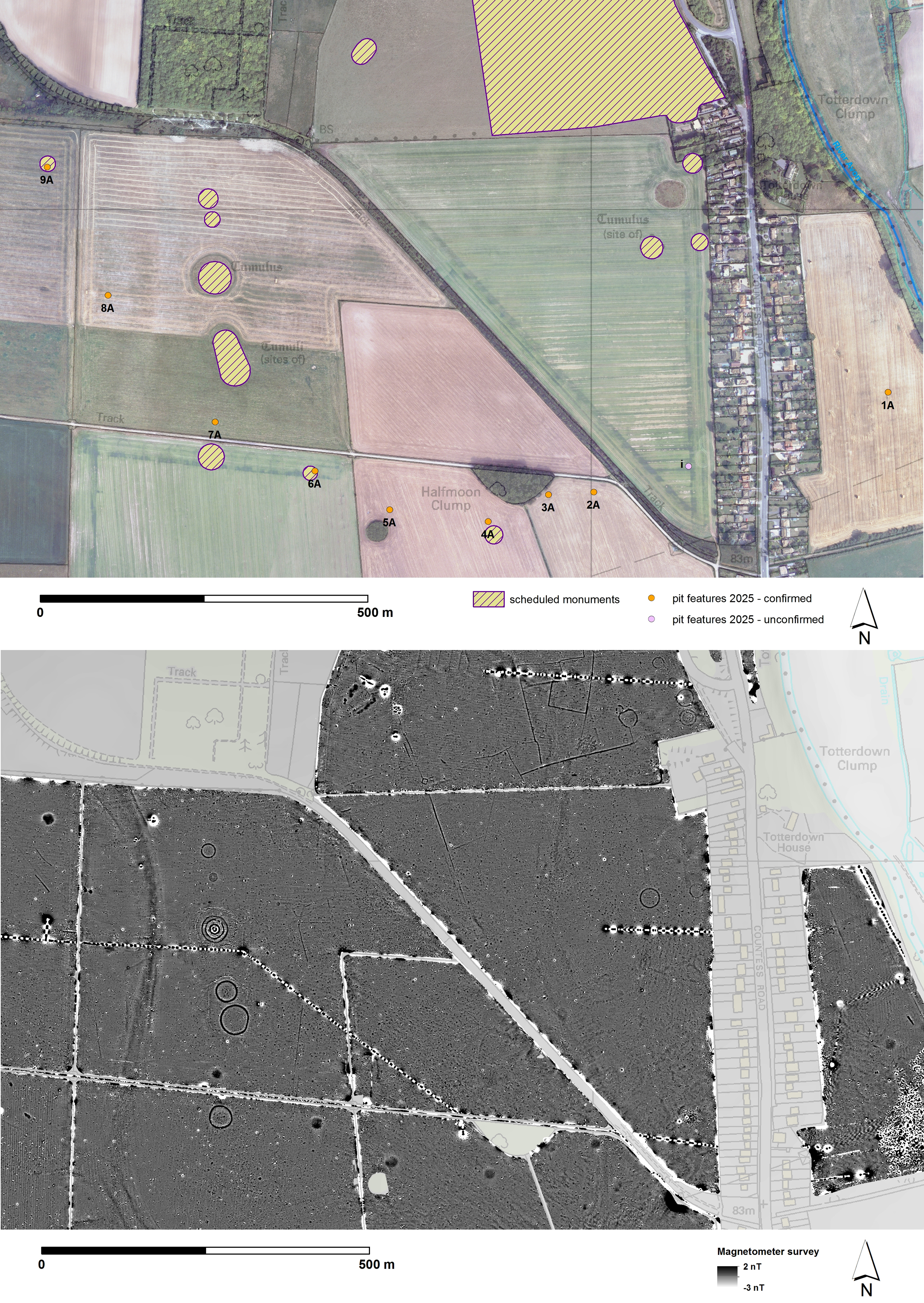
Figure 1: Plan of the pit structure associated with Durrington Walls Henge. Features 1A–9A form an 'arc' south of Durrington Walls in Amesbury parish, while 10D–16D (formerly v) form a northern 'arc' in Durrington parish. Four additional features, noted from other sources including aerial photographs, excavation or topographic modelling, are annotated with roman numerals i–iv. Lidar derived digital surface model (shaded) with OS 10K overlay © Environment Agency copyright and database right 2024. All rights reserved. Lidar (composite sources) DTM 1m resolution, Scale 1:4000 with gaps filled by DTM 2m resolution, Scale 1:8000 – Ordnance Survey (100025252)/EDINA supplied Service. http://digimap.edina.ac.uk
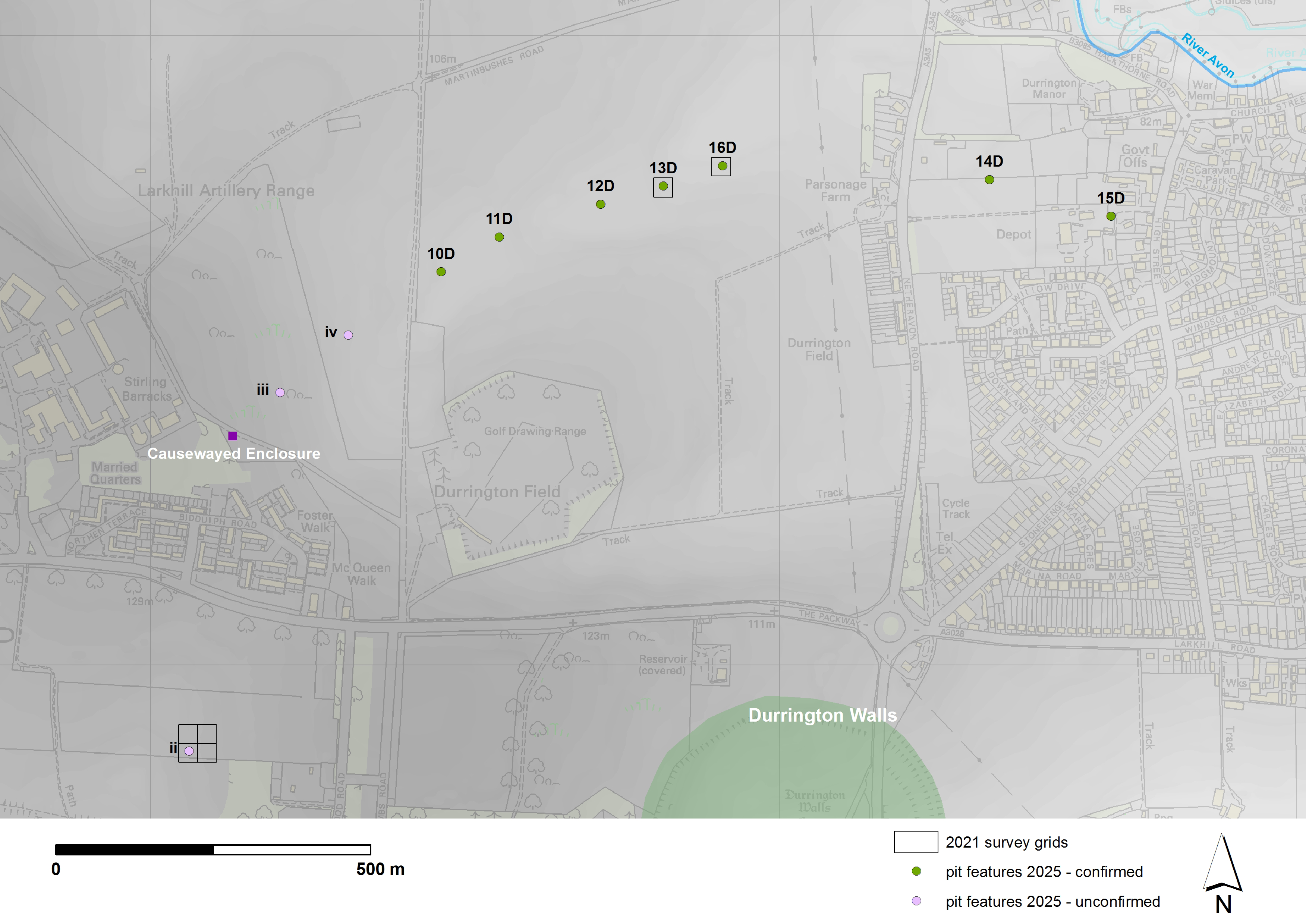
Figure 2: Geophysical survey grid locations for northern anomalies ii, 13D and 16D. These were initially single 30 x 30m grids, although the grid over ii was subsequently expanded to cover an area 60 x 60m. Lidar derived digital surface model (shaded) with OS 10K overlay © Environment Agency copyright and database right 2024. All rights reserved. Lidar (composite sources) DTM 1m resolution, Scale 1:4000 with gaps filled by DTM 2m resolution, Scale 1:8000 – Ordnance Survey (100025252)/EDINA supplied Service. http://digimap.edina.ac.uk
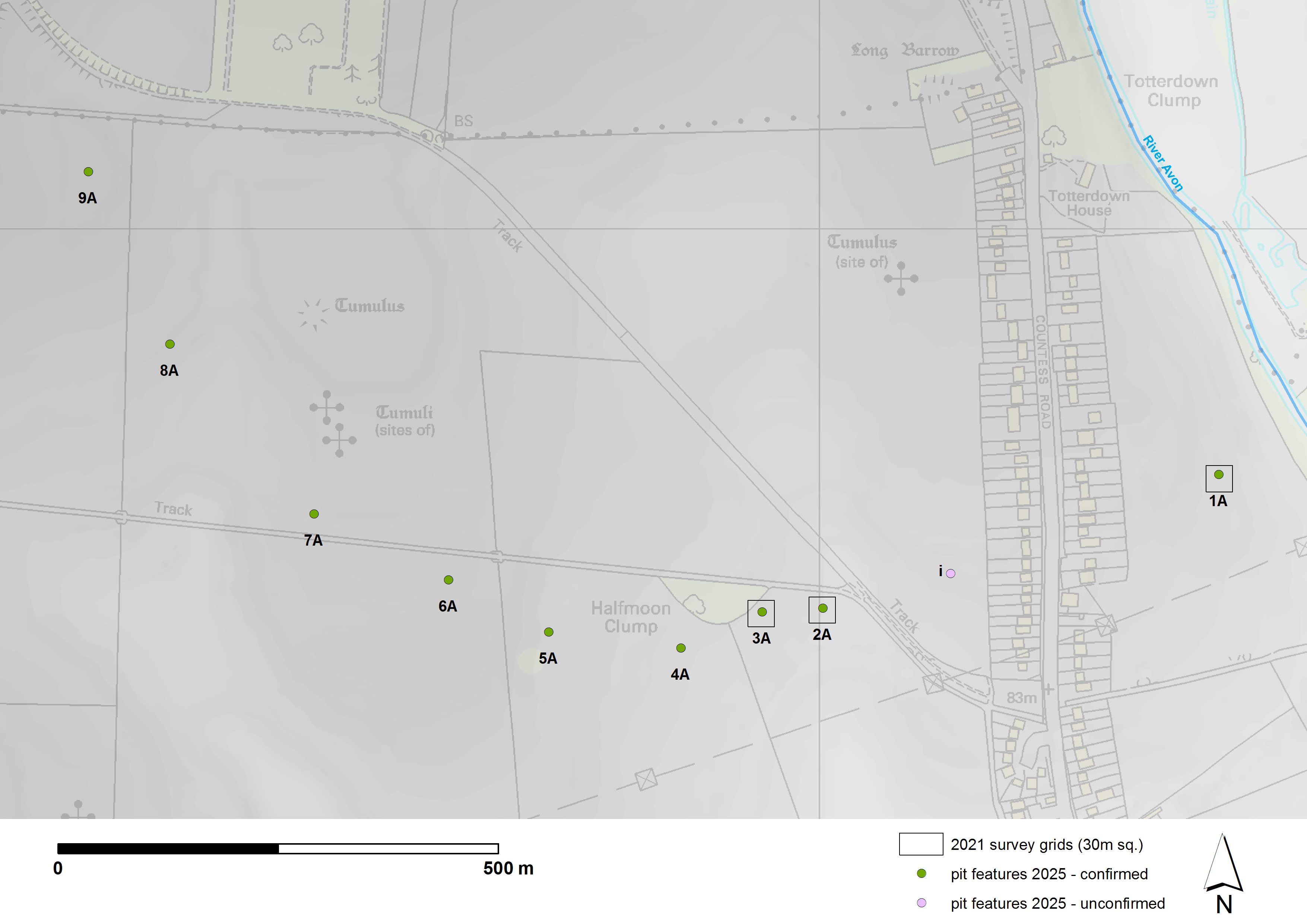
Figure 3: Geophysical survey grid locations for southern anomalies 1A, 2A, and 3A, all single 30 x 30m grids. Lidar derived digital surface model (shaded) with OS 10K overlay © Environment Agency copyright and database right 2024. All rights reserved. Lidar (composite sources) DTM 1m resolution, Scale 1:4000 with gaps filled by DTM 2m resolution, Scale 1:8000 – Ordnance Survey (100025252)/EDINA supplied Service. http://digimap.edina.ac.uk
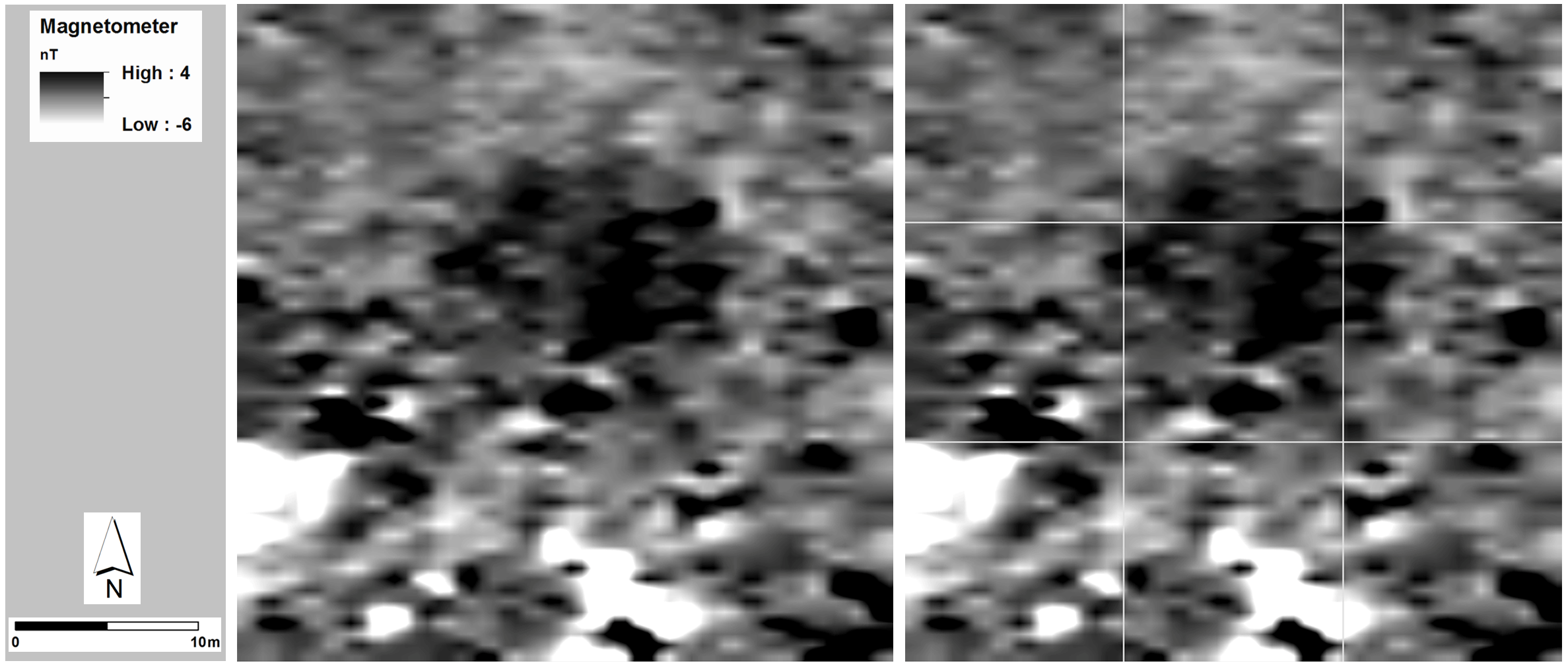
Figure 4: Fluxgate gradiometer survey (30m x 30m) over 13D – processed results at 0.25m x 0.25m spatial resolution (left, and with 10m gridlines right) confirm the location of a previously mapped magnetic anomaly (Schmidt and Crabb 2017, anomaly 6016) approximately 14m in diameter. Greyscale legend: positive (black), negative (white)
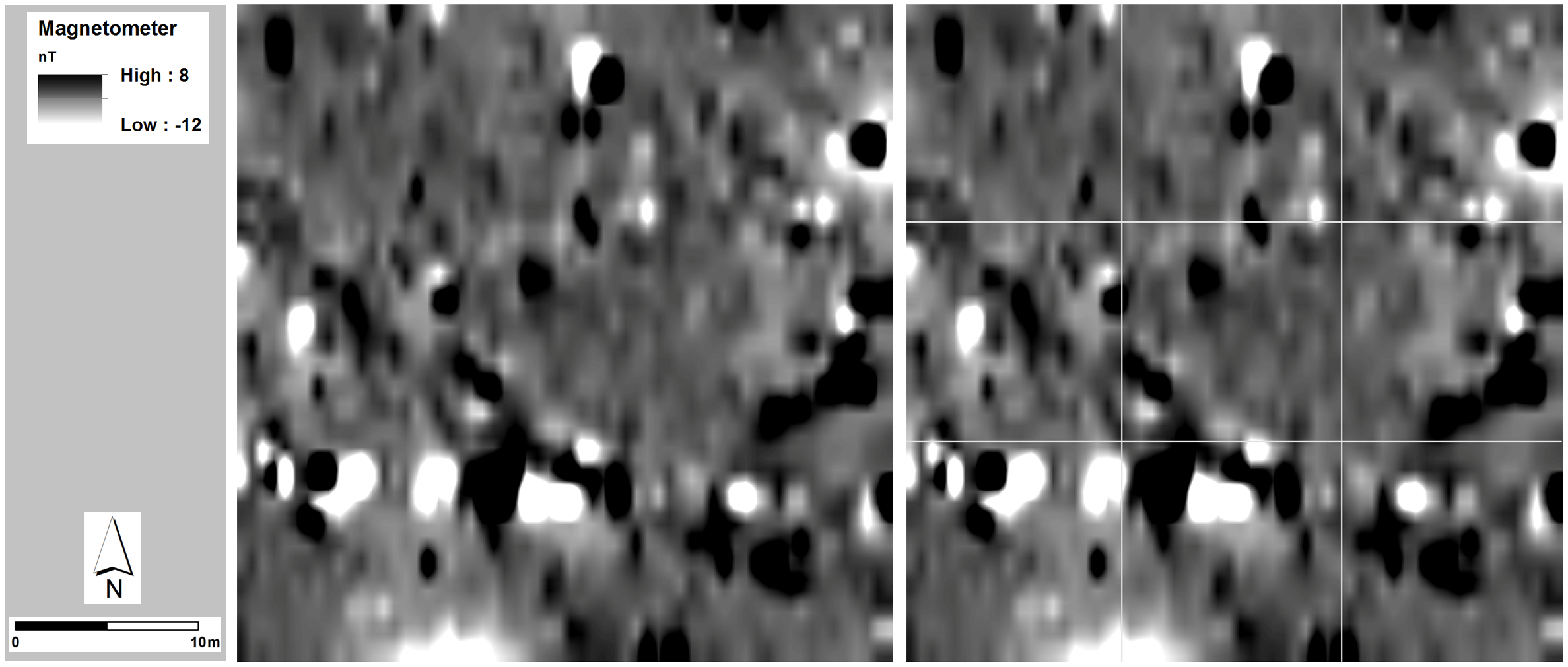
Figure 5: luxgate gradiometer survey (30m x 30m) over 16D - identified previously as a cropmark (Gaffney et al. 2020) – processed results at 0.25m x 0.25m spatial resolution (left), and with 10m gridlines (right), reveal a previously unmapped magnetic anomaly (approximately 18–20m in diameter, consistent in response and dimension to 15 other pit features identified by Gaffney et al. (2020). Greyscale legend: positive (black), negative (white)
Figure 6: Fluxgate gradiometer survey (30m x 30m grid extracted from a larger area survey – see supplementary data file 1, figs 1.5 and 1.6) over anomaly ii, identified previously as a topographic feature (Gaffney et al. 2020) and a cropmark (Crutchley 2002). Processed results at 0.25m x 0.25m spatial resolution (left), and with 10m gridlines (right), reveal a previously unmapped curvilinear magnetic anomaly (approximately 18–20m in diameter), however it is not consistent in magnetic response to 15 other pit features (now 16) identified by Gaffney et al. (2020), and most probably relates to 20th century military activity in the area. Greyscale legend: positive (black), negative (white)
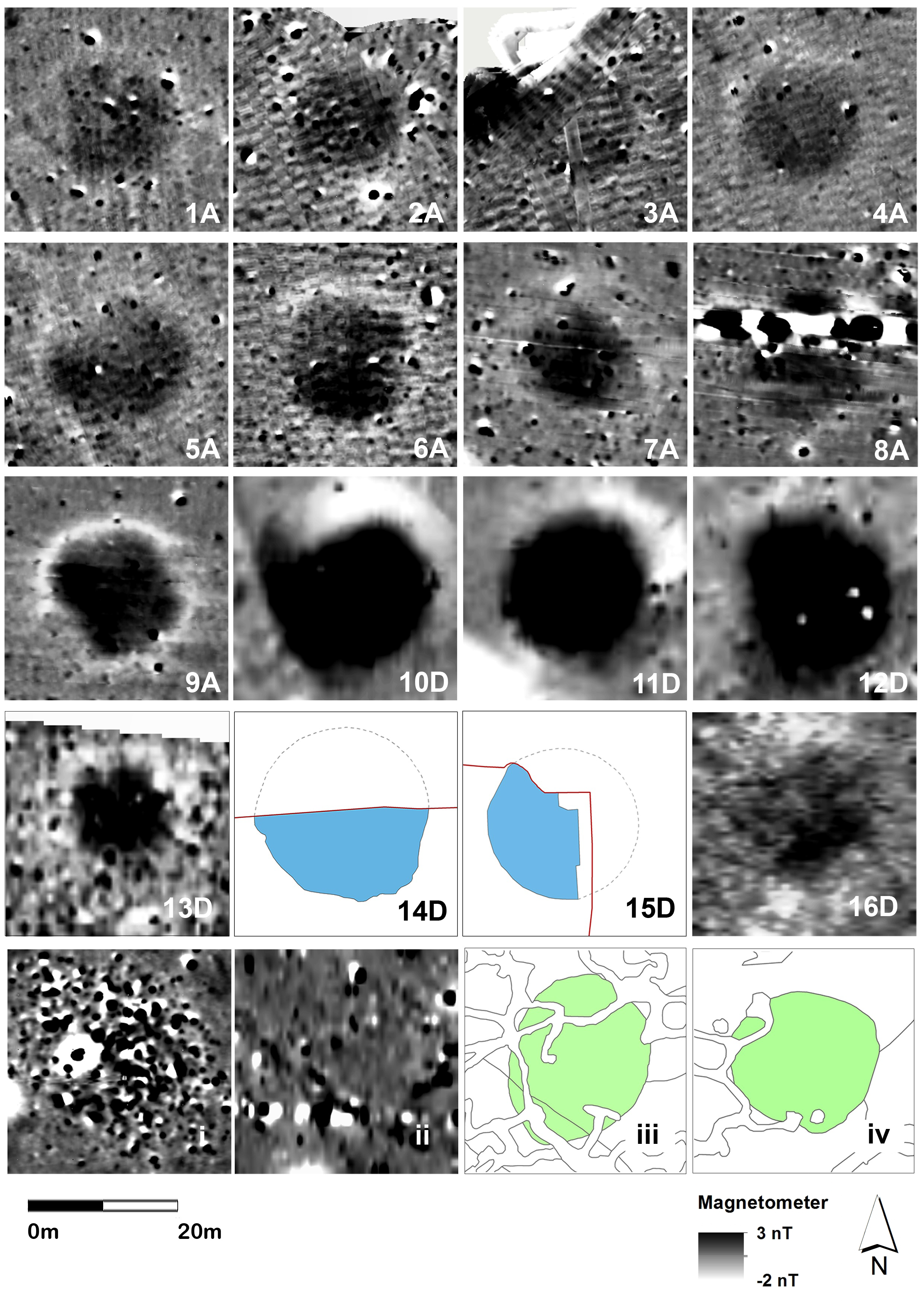
Figure 7: Composite image of 14 magnetic anomalies (1A–9A, 10D–13D and 16D) of similar magnetic character and size. Features 14D and 15D were documented through excavation and are of similar nature and size to the magnetic anomalies. Potential features i, iii, iv remain to be proven. Although similar in size, magnetic anomaly ii displays a dissimilar magnetic characteristic to the others
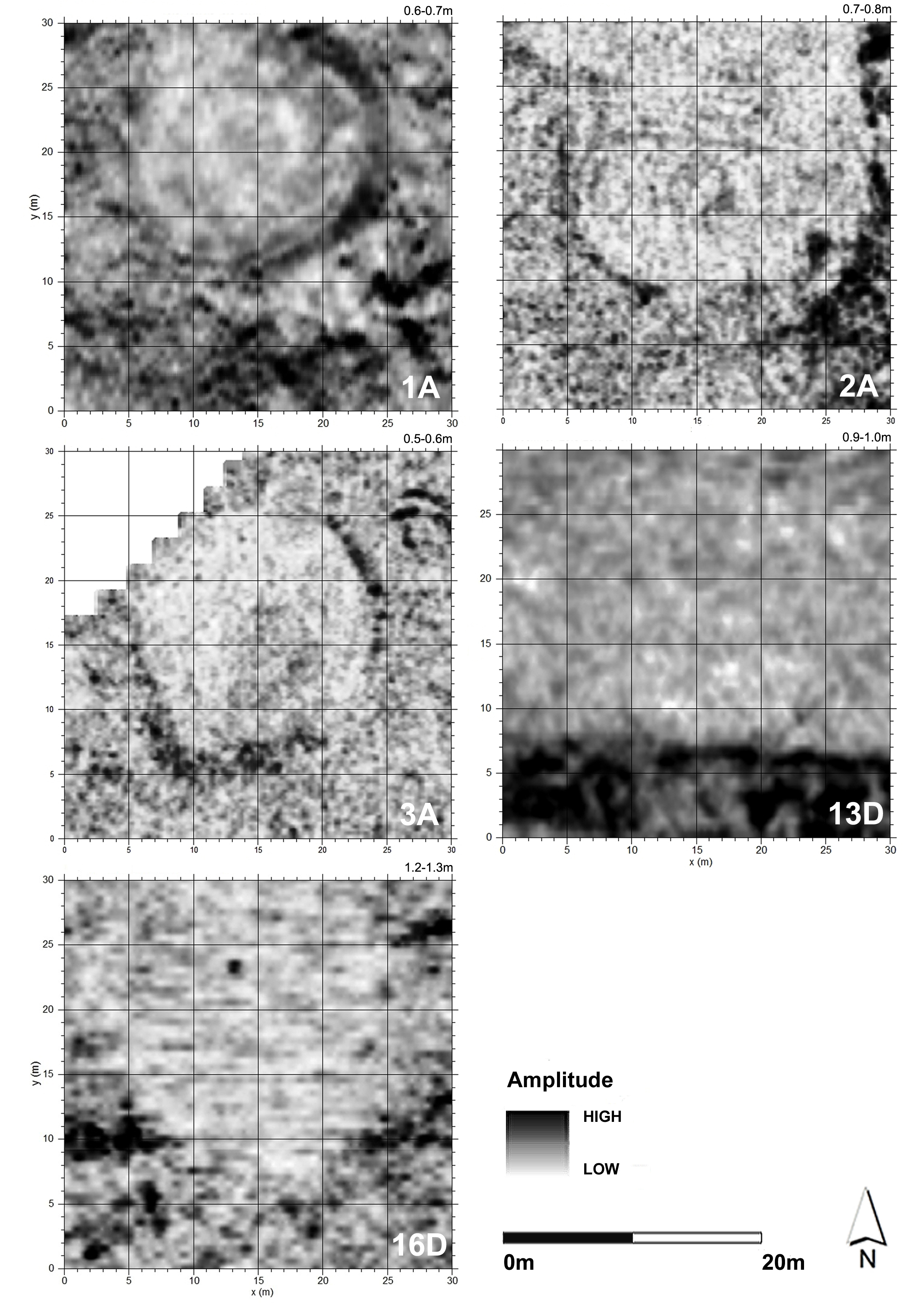
Figure 8: GPR time slices from 1A, 2A, 3A, 13D, and 16D, ranging between an estimated 0.6m–1.3m depth, with 5m grid line intervals marked. North top. Greyscale: high amplitude – black, low amplitude – white
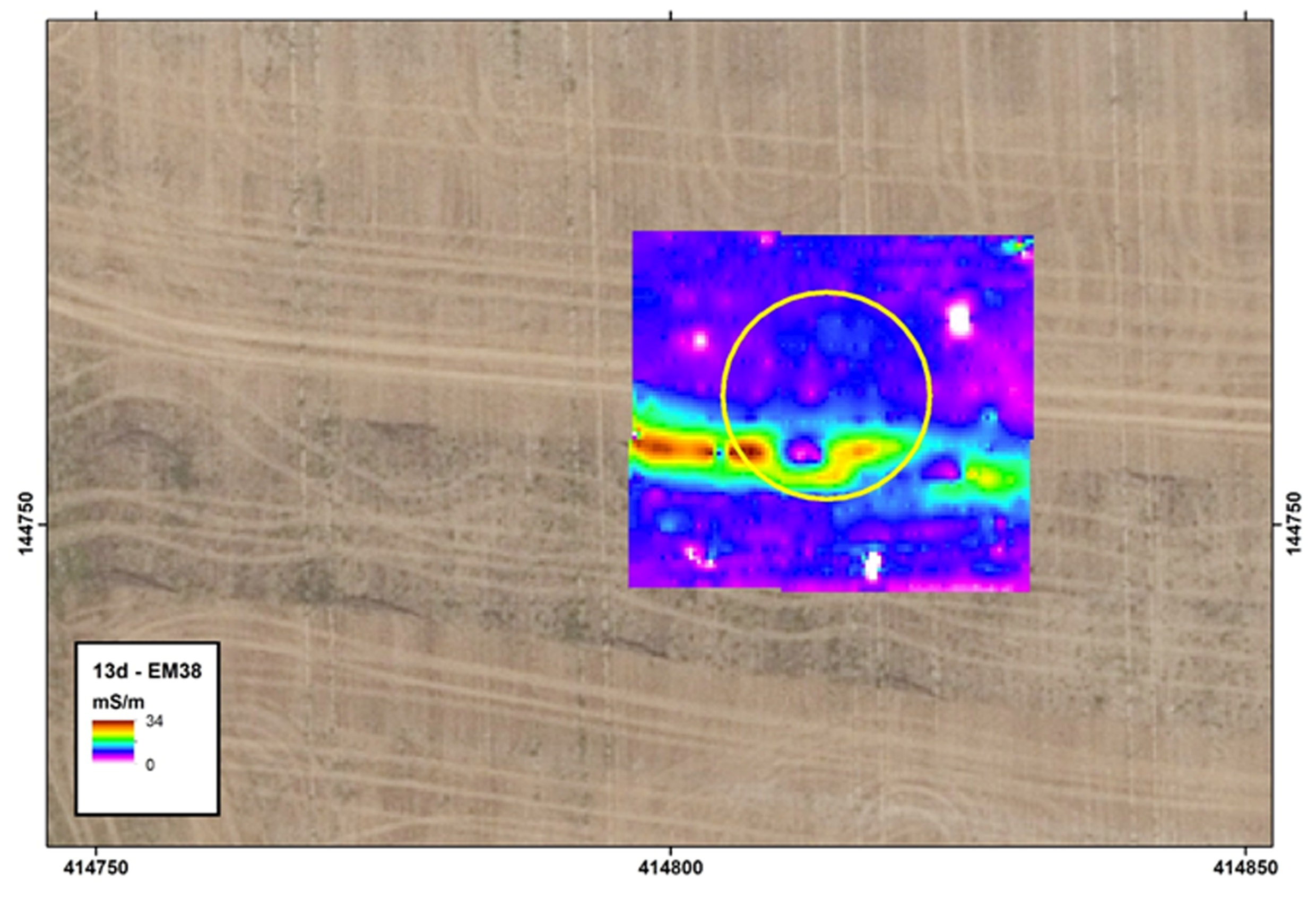
Figure 9: Deployment of the EM38 conductivity meter over 13D showed conductivity variation of 2-34mS/m with high values associated with an E–W trending linear most likely associated with recent archaeological investigations (Leivers et al. 2020). No signature was associated with the target location. Backdrop © Google Earth
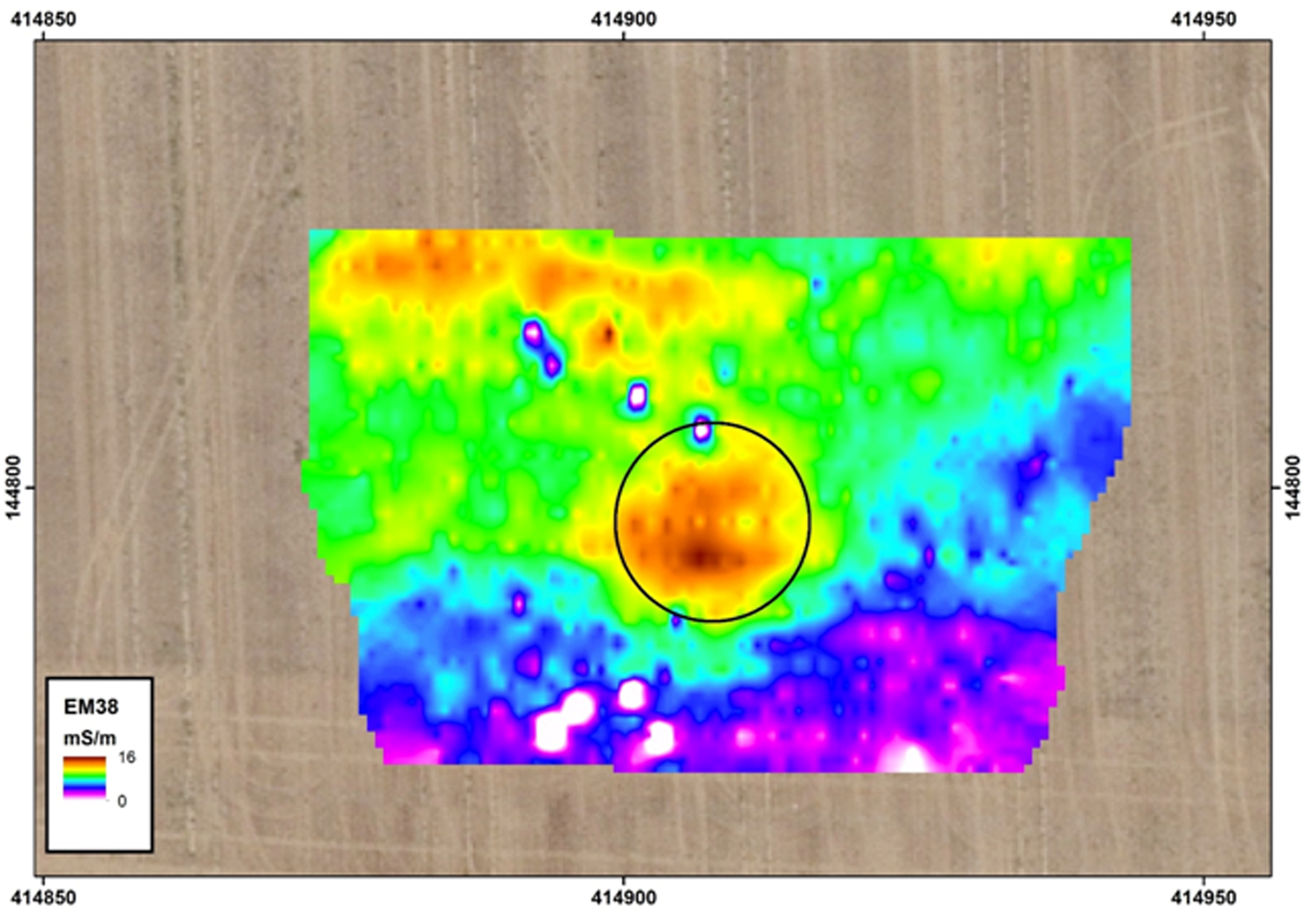
Figure 10: Deployment of the EM38 conductivity meter in horizontal mode over anomaly 16 showed a pattern of generally increasing ground conductivity from south to north across the survey area (top). There was a consistent pattern of higher ground-conductivity associated with the target location (circled). Backdrop © Google Earth
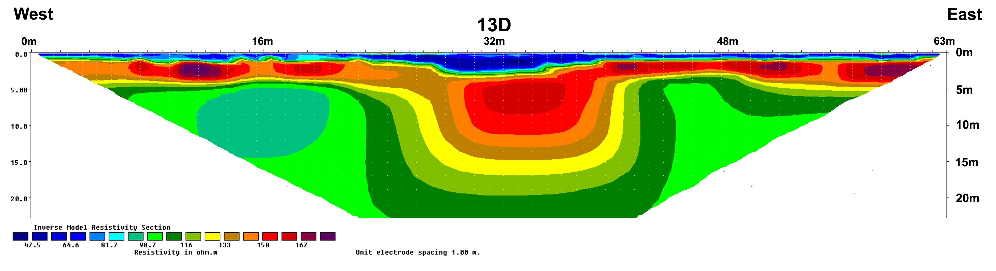
Figure 11: ERT profile across 13D (1m electrode spacing) – a low-resistivity signal located centrally within the profile coincides with the location of 13D. The bottom of the anomaly appears to be at a depth of 4–5m. Colour legend: high resistivity (dark red), low resistivity (dark blue).
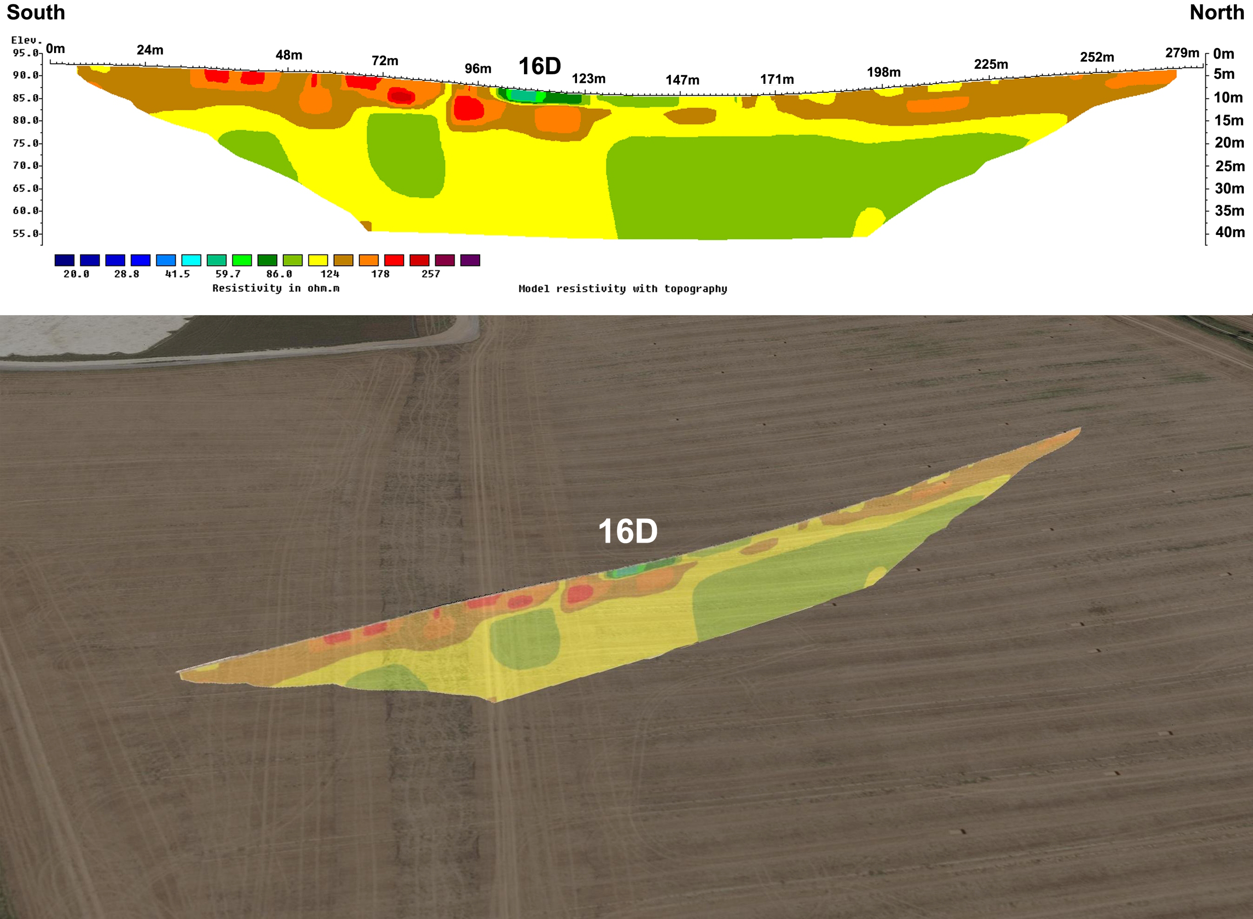
Figure 12: (Top) Vertical ERT profile (3m electrode spacing with topography) running south–north across the dry valley and through 16D – (bottom) the same long-line ERT profile visualised at landscape scale. Colour legend: high resistivity (dark red), low resistivity (dark blue). Backdrop © Google Earth
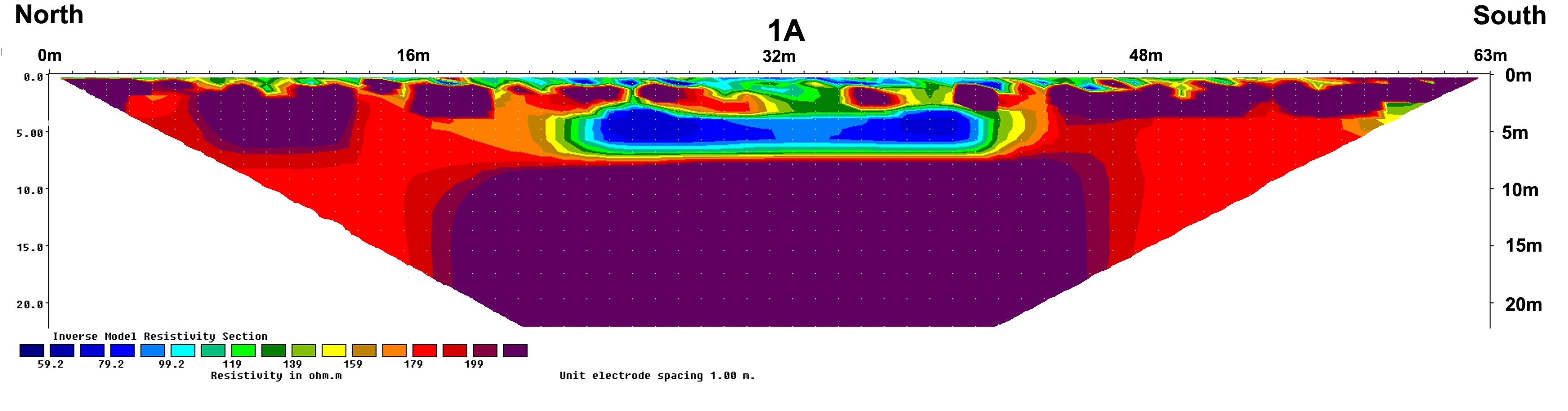
Figure 13: ERT profile across 1A (1m electrode spacing, north–south) – a low-resistivity signal located centrally within the profile coincides with the location of 1A. The bottom of the anomaly appears to be at a depth of <5m. Colour legend: high resistivity (dark red), low resistivity (dark blue)< /p>
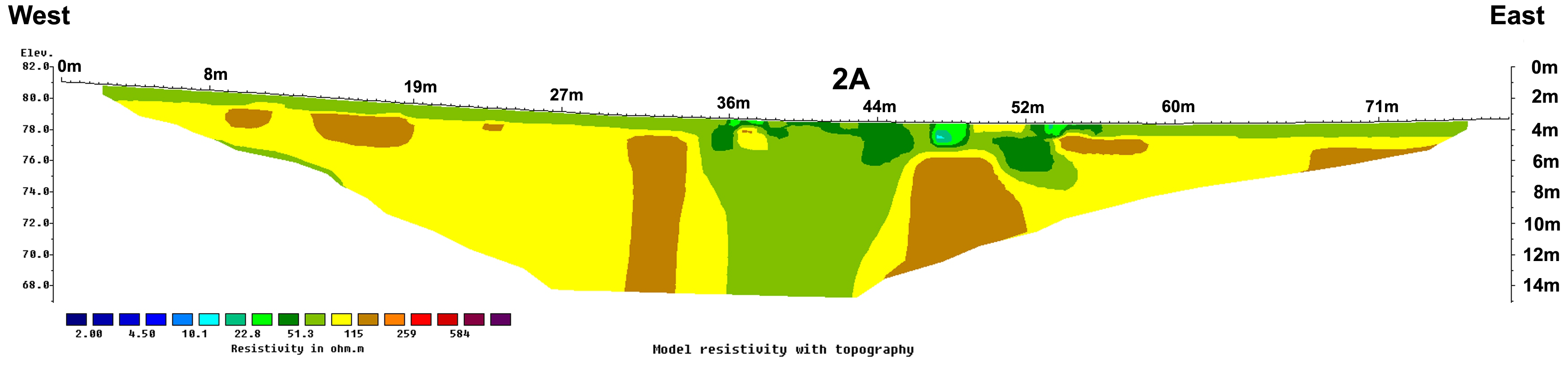
Figure 14: ERT profile (1m electrode spacing with topography) across 2A. Low-resistivity measurements coincide with the target. Colour legend: high resistivity (brown), low resistivity (blue)
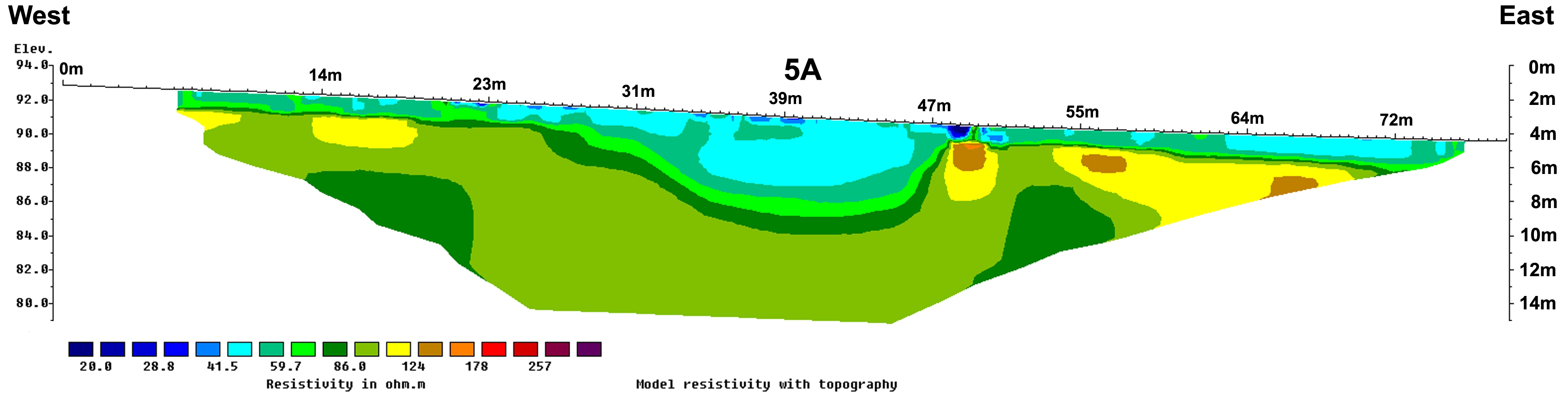
Figure 15: Results for ERT survey at anomaly 5A (top), 0.5m electrode spacing (bottom), 1m electrode spacing. Colour legend: high resistivity (dark red), low resistivity (dark blue)
Figure
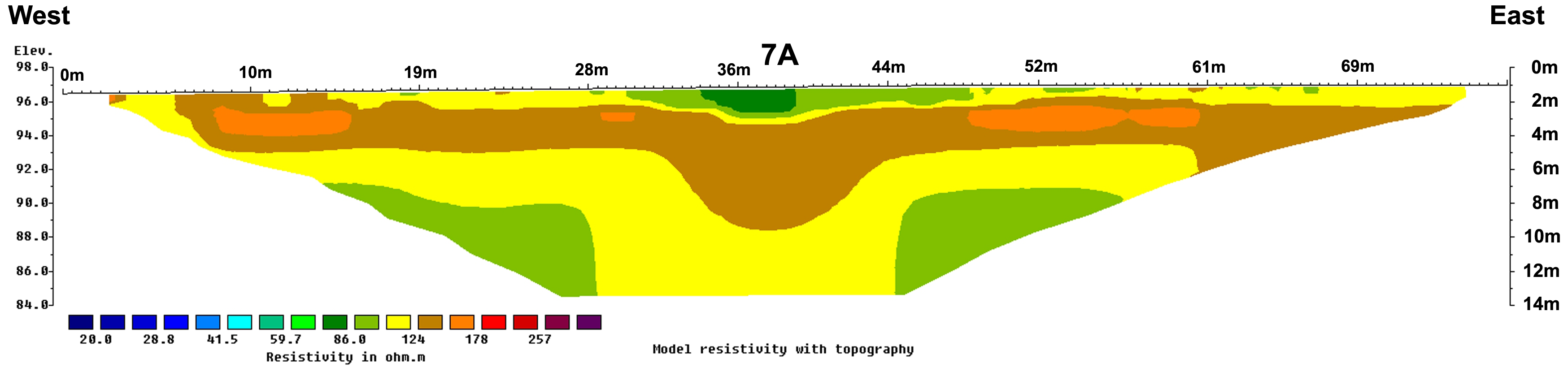
16: ERT profiles over 7A – (Top) 0.5m electrode spacing. Low-resistivity
measurements coincide with the target feature. Colour legend: high resistivity (dark red),
low resistivity (dark blue).
Animation of ERT profile from 7A (0.5m electrode
spacing) visualised in landscape setting with 2013 magnetometer survey overlay (courtesy LBI
ArchPro, see Gaffney et al. 2020, supplementary data file 1). Colour legend: high
resistivity (brown), low resistivity (blue). Greyscale legend: magnetometer – positive
(black), negative (white). This video does not contain audio
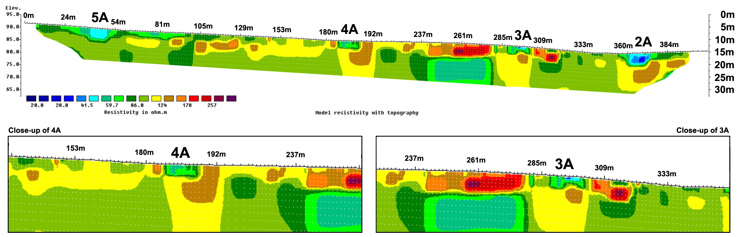
Figure 17: Long-line ERT profile (3m electrode spacing with topography) across 5A, 4A, 3A and 2A with close-up of 4A and 3A. Low-resistivity measurements coincide with the target features. Colour legend: high resistivity (dark red), low resistivity (dark blue)
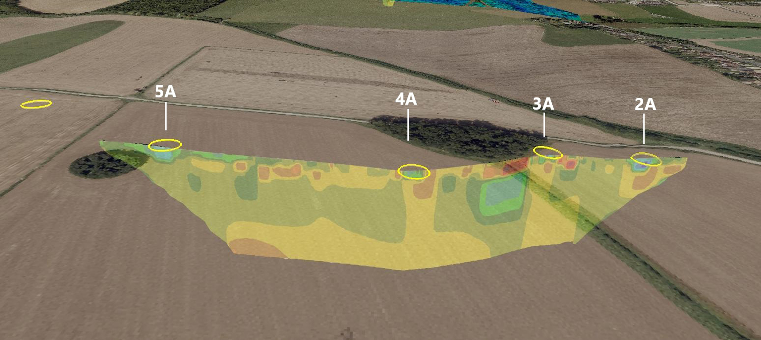
Figure 18: Landscape perspective – long-line ERT profile (3m electrode spacing with topography) across 5A, 4A, 3A and 2A. Low-resistivity measurements coincide with the target features. Colour legend: high resistivity (dark red), low resistivity (dark blue). Overlain on aerial photograph backdrop © Google Earth
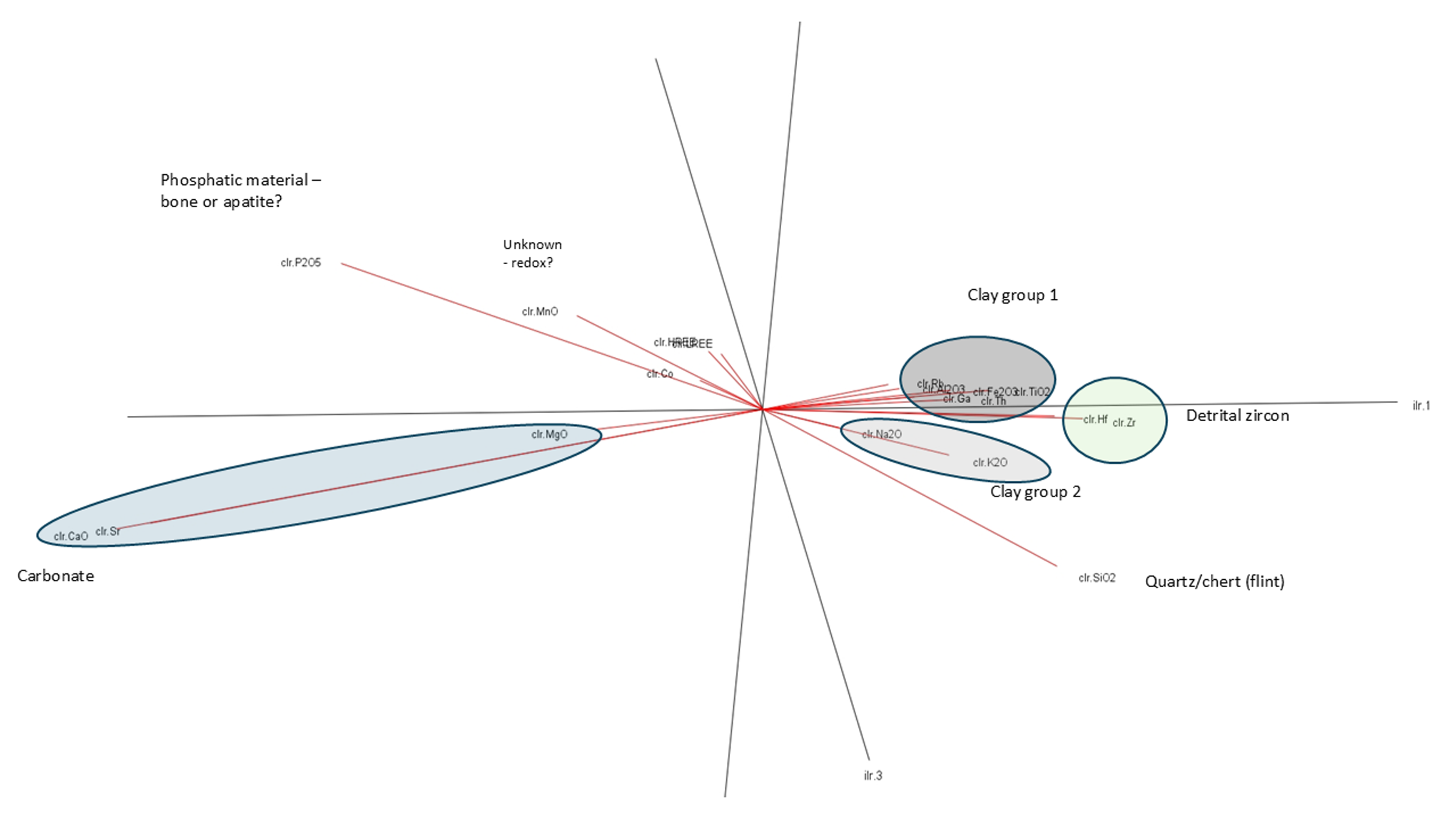
Figure 19: Principal Component Analysis (PCA) of all geochemical data collected in this study. Elements highlighted are labelled with probable control of composition, e.g. CaO and MgO likely reflect variations in carbonate (chalk) content of the analysed sample
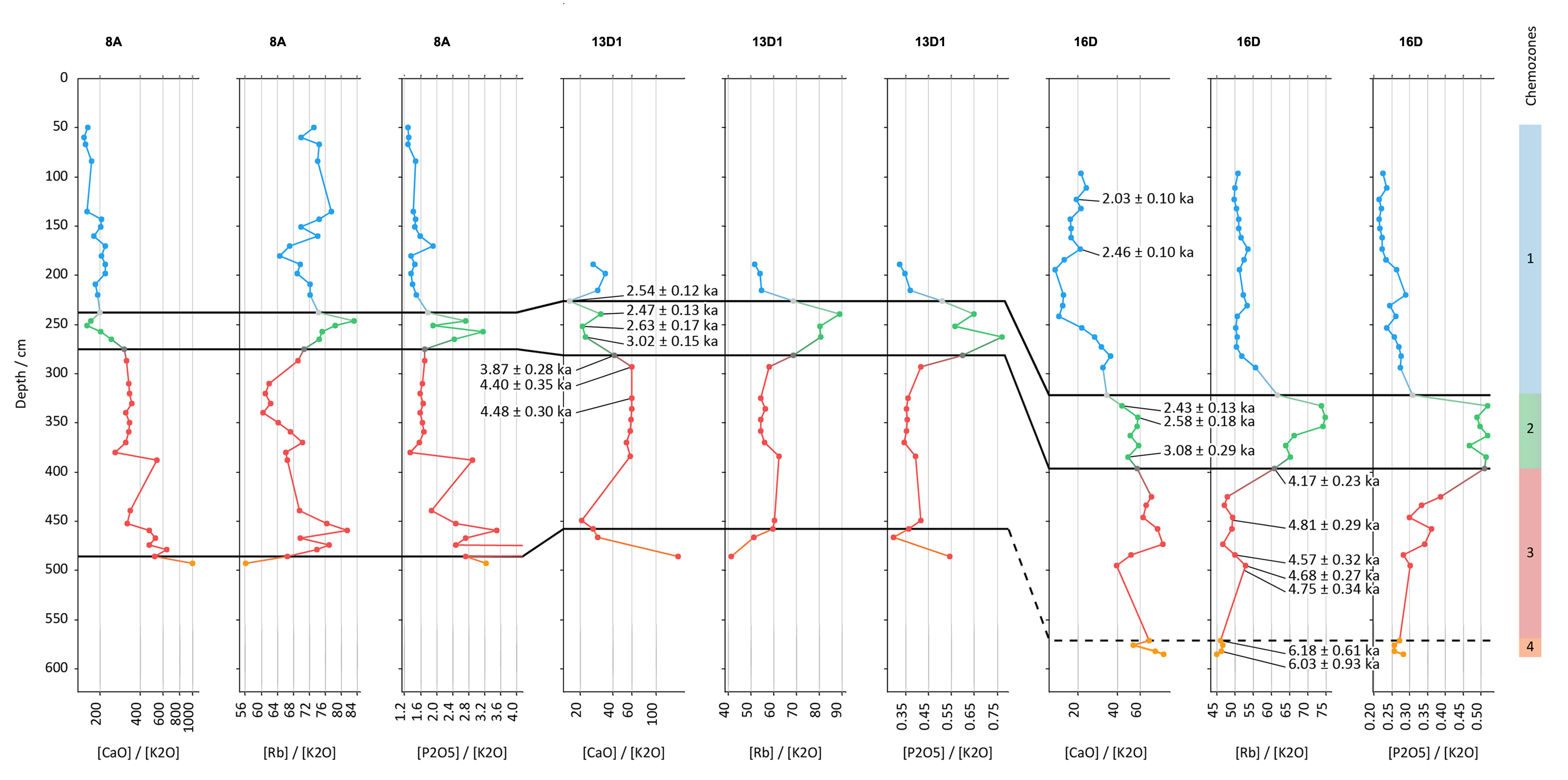
Figure 20: Chemostratigraphic correlation across core window samples (WS) from anomalies 8A, 13D (1) and 16D. The chemostratigraphy reveals three correlate zones based on changes in CaO/K2O (likely representing chalk/clay), Rb/K2O (likely representing changes in clay mineralogy) and P2O5/K2O (possibly bone content/clay minerals). Colour shading: blue = chemo zone 1, green = chemo zone 2, red = chemo zone 3 and orange = chemo zone 4
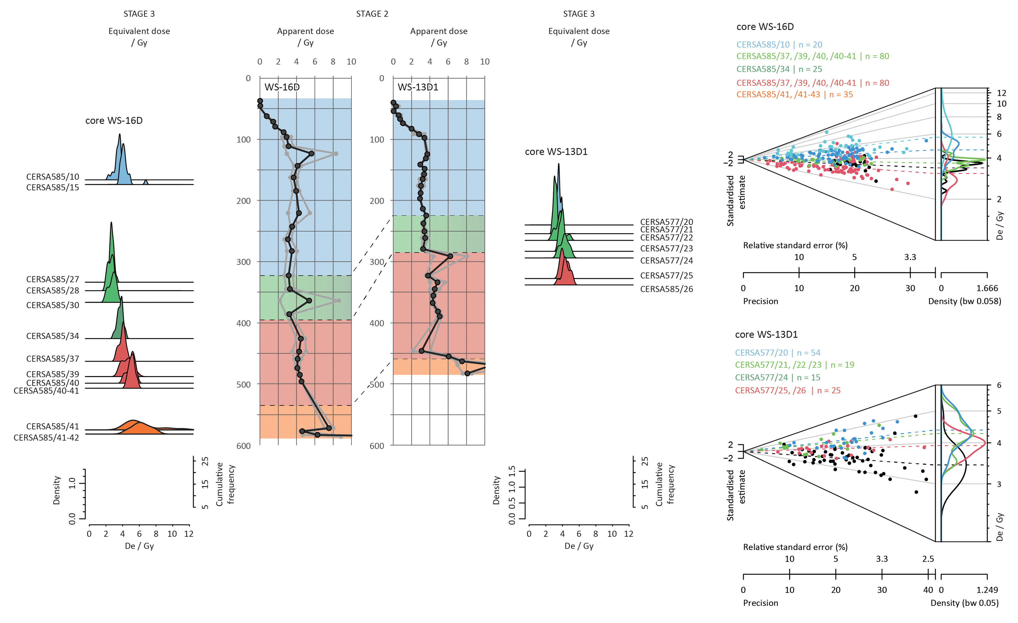
Figure 21: Equivalent dose distributions for samples from cores WS 16D and WS 13D (1), shown as kernel density estimate plots and Abanico plots. Colour shading: blue = chemo zone 1, green = chemo zone 2, red = chemo zone 3 and orange = chemo zone 4
Figure 22: Location of the Durrington pits showing the distribution of Ovis and Bos signals within the pits sampled. Bos appear in all pits sampled, irrespective of location. Ovis appear to be localised to those pits to the south of the monument. Lidar-derived digital surface model (shaded) with OS 10K overlay © Environment Agency copyright and database right 2024. All rights reserved. Lidar (composite sources) DTM 1m resolution, Scale 1:4000 with gaps filled by DTM 2m resolution, Scale 1:8000 – Ordnance Survey (100025252)/EDINA supplied Service. http://digimap.edina.ac.uk
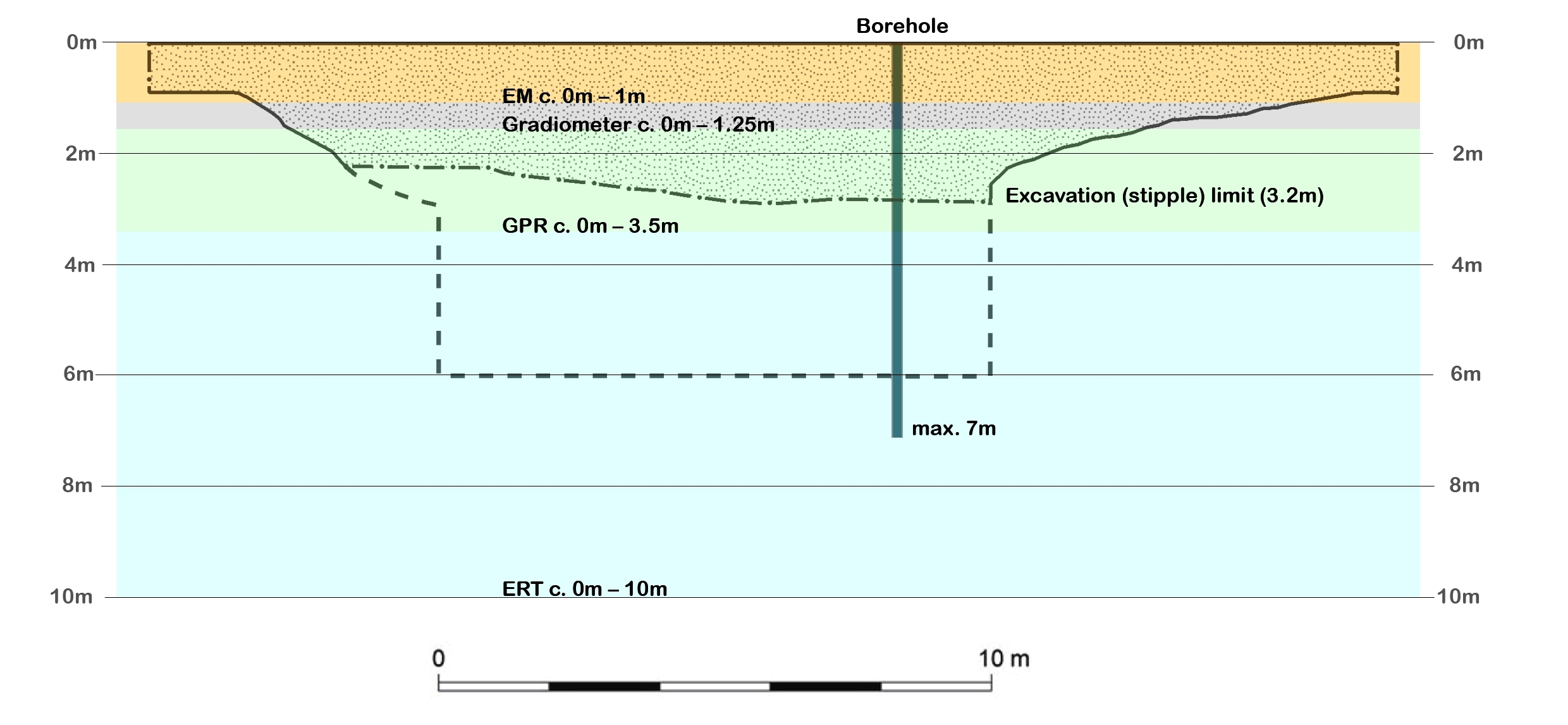
Figure 23: Schematic comparing depth penetration of investigative exploratory methods against potential pit depths and maximum depths of previous excavations undertaken prior to development
Figure 24: Top – features recorded as potential comparator data for those features identified as pits (after Ruggles and Chadburn 2024, fig. 3). Bottom – magnetic anomalies (1A–9A) and potential anomaly i overlain OS 10K mapping. Fluxgate gradiometer survey mapped as part of the Stonehenge Hidden Landscapes Project and supplied by LBI ArchPro, Vienna. Note the clear qualitative difference between features identified as potential pits and those suggested as comparators (see supplementary data file 10 for detail). (Top) OS 10k overlay with aerial base map 25cm (Get Mapping) – Ordnance Survey (100025252)/EDINA supplied Service; Department of Environment, Food & Rural Affairs (Defra), 'Scheduled Monuments' [last accessed: 18.09.2024] (Bottom) OS 10K underlay © Crown and database rights 2024. All rights reserved. – Ordnance Survey (100025252)/EDINA supplied Service. http://digimap.edina.ac.uk
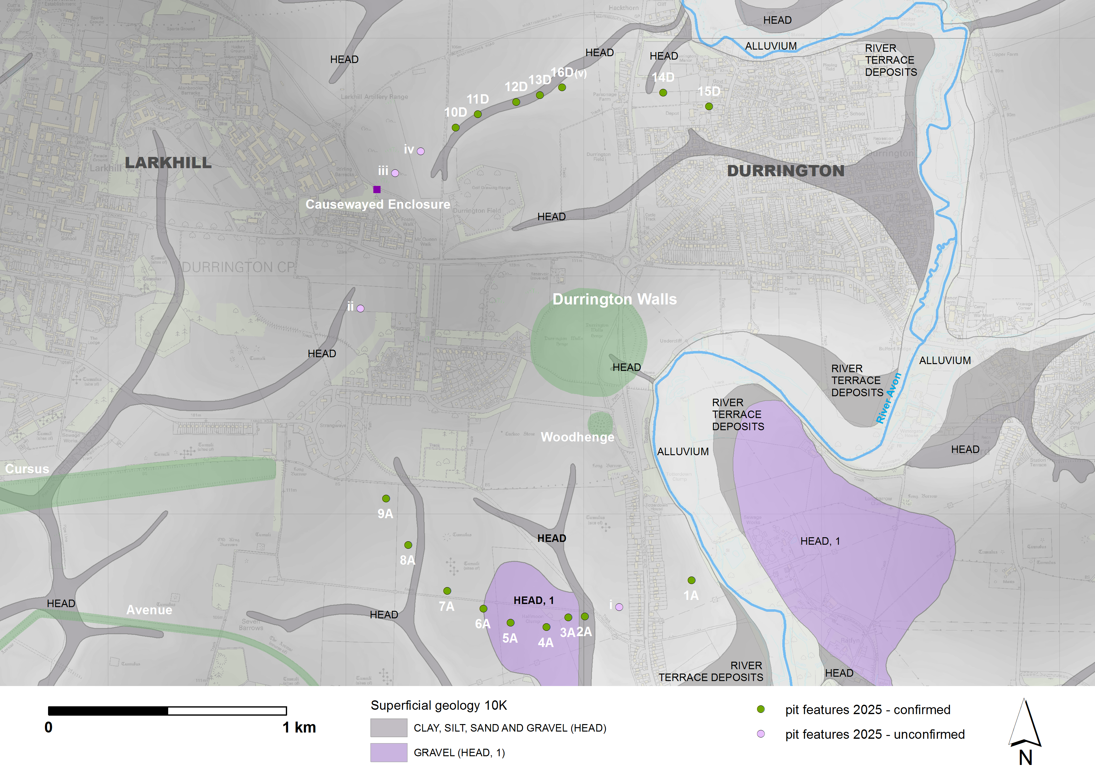
Figure 25: Geological overview of probable and possible pits in relation to superficial head deposits of clay, silt, sand and gravel often associated with dry valleys (marked in grey). As regards pits investigated in 2021: 3A, 4A, and 5A occur within area of Head deposit, 1 - gravel (BSG REF 625), while 2A and 13D occur within areas of Head deposit - clay, silt, sand and gravel (BSG REF 424). © Crown copyright and database rights 2024 – Ordnance Survey (100025252)/EDINA supplied Service (OS MasterMap® Scale 1:1250 and OS Profile DTM (5m resolution) Scale 1:10K); British Geological Survey/EDINA supplied service (BGS Superficial deposits 1:10K – Sheet SU14SW v2.18). http://digimap.edina.ac.uk
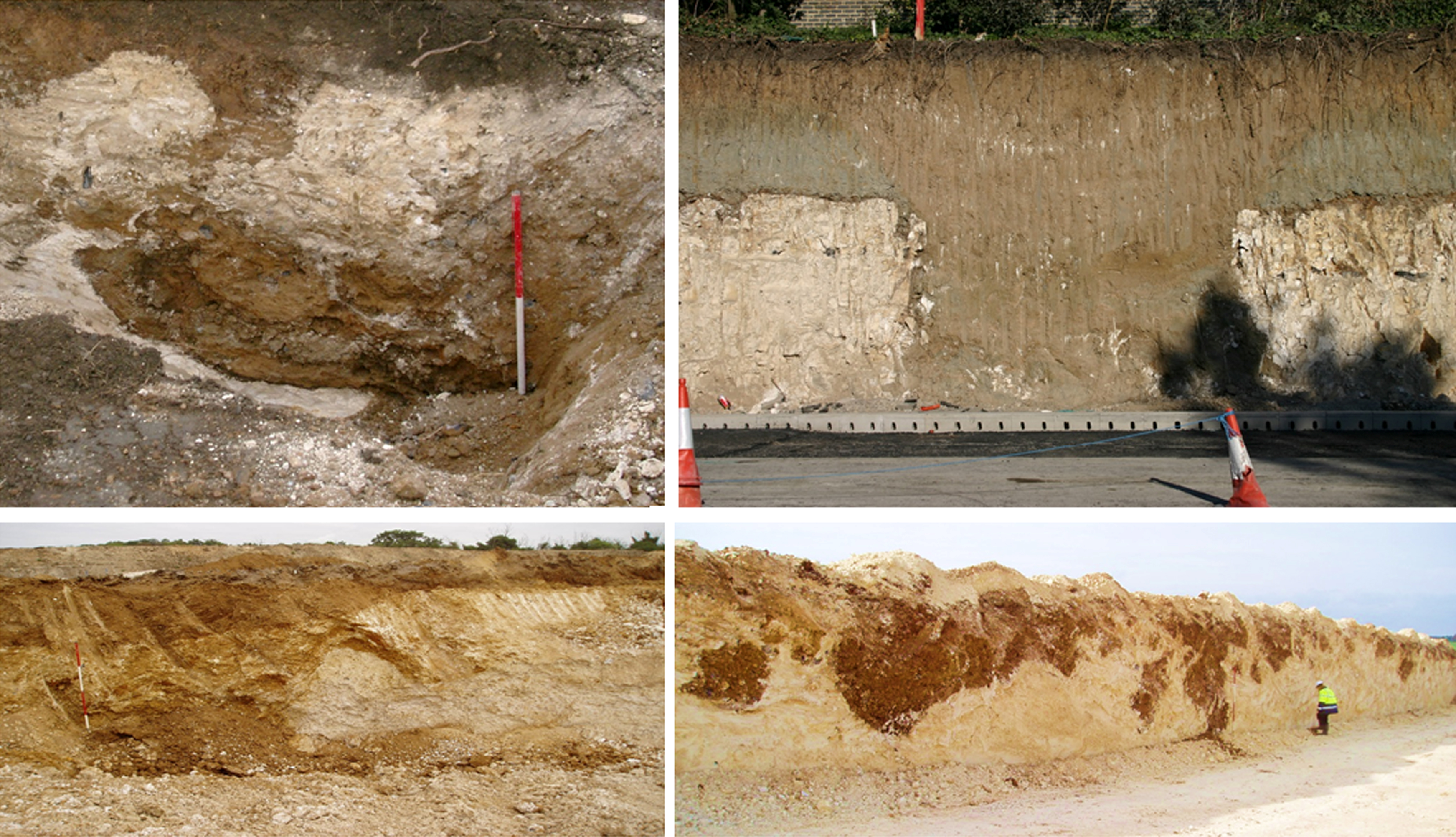
Figure 26: Top Left – Station Quarter South Ebbsfleet solution features. Note the dark brown contact between the Chalk and overlying sediments. Top Right – Large pit cut through chalk and Thanet Sand near Ebbsfleet, Kent. Note steep sides, sub-horizontal bedding and lack of the brown rim along the edge one finds in solution hollows. Bottom – Solution features in the Chalk at Dartford A2/M25 works. Note the undulating surfaces and the haphazardly filled features
Table 1: Table 1: Pit features investigated in 2021 and 2019 fieldwork – summary of large pit anomalies
Table 2: Fieldwork undertaken in 2021 with laboratory analyses – progress overview of investigations
Table 3: Magnetometer surveys 2021 – summary. March 2021 – Bartington Grad 601 Dual sensor magnetic survey
Table 4: GPR surveys 2021 summary. Favourable ground surface conditions (dry, stone free) for cart-mounted GPR survey permitted closer sampling intervals over 2A and 3A.
Table 5: Summary of dimension (avg.) as discerned by technique (invasive and non-invasive) undertaken by the Stonehenge Hidden Landscapes project and Wessex Archaeology 2012–2025
Table 6: Electromagnetic surveys 2021 summary. March 2021 Fieldwork
Table 7: Electrical Resistance Tomography surveys – 2021 summary
Table 8: Summary of borehole investigations 2021
Table 9: Core window samples (WS) analysed by ICP techniques for this study. Cores were selected from both northern and southern 'arcs' based on sample availability and, where possible, overlap with other analyses
Table 10: Results summary table of the burial doses, total effective environmental dose rates and OSL depositional ages obtained from sediment recovered from cores WS 1A, WS 2A, WS 16D, WS 13D (1) and WS 13D (2): core sub-samples are labelled with a sequential numeric suffix
Table 11: Summary and interpretation of the chemostratigraphic analysis of core window samples (WS) from WS 8A, WS 13D (1) and WS 16D, with OSL ages for boundaries
AAME 2023 'The Aerial Archaeology Mapping Explorer (AAME) portal', Historic England [website] https://historicengland.org.uk/research/results/aerial-archaeology-mapping-explorer/ [Last accessed: 28 May 2025]
Alberge, D. 2023 'Discovery of up to 25 Mesolithic pits in Bedfordshire astounds archaeologists', The Guardian [website], 3 June 2023. https://www.theguardian.com/science/2023/jul/03/discovery-25-mesolithic-pits-bedfordshire-astounds-archaeologists [Last accessed: 26 March 2025]
Allaby, R., Ware, R., Cribdon, R., Hansford, T., Kinnaird, T., Hamilton, W., Kistler, L., Murgatroyd, P., Bates, R., Fitch, S. and Gaffney, V. 2023 'Pleistocene-Holocene sedaDNA reconstruction of Southern Doggerland reveals early colonization before inundation consistent with northern refugia', 21 September 2023, PREPRINT (Version 1), Research Square. [Last accessed: 11 June 2025] https://doi.org/10.21203/RS.3.RS-3296992/V1
Baldwin, E. and V. Gaffney 2020 'Interim report on the recent discovery of a series of massive pits near the Durrington Walls henge', Unpublished Report for the National Trust, University of Birmingham
Bøtter-Jensen, L., McKeever, S.W. and Wintle, A.G. 2003 Optically Stimulated Luminescence Dosimetry, Amsterdam: Elsevier. https://doi.org/10.1016/B978-0-444-50684-9.X5077-6
Bowden, M., Soutar, S., Field, D. and Barber, M. 2015 The Stonehenge Landscape. Analysing the Stonehenge World Heritage Site, Swindon: Historic England.
Bradley, R. 1998 The Significance of Monuments, London: Routledge.
Bradley, R. 2012 The Idea of Order: The Circular Archetype in Prehistoric Europe, Oxford University Press. https://doi.org/10.1093/oso/9780199608096.001.0001
Ch'ng, E., Gaffney, V. and Hakvoort, G. 2014 'Stigmergy in comparative settlement choice and palaeoenvironment simulation', Complexity 21(3), 59–73. https://doi.org/10.1002/cplx.21616
Chartres, C.J. and Whalley, W.B. 1975 'Evidence for Late Quaternary solution of Chalk at Basingstoke, Hampshire', Proceedings of the Geologists' Association 86(3), 365–72. https://doi.org/10.1016/S0016-7878(75)80027-7
Condit, T. and Keegan, M. 2018 'Aerial investigation and mapping of the Newgrange landscape, Brú na Bóinne, Co. Meath. The Archaeology of the Brú na Bóinne World Heritage Site Interim Report, December 2018, Department of Culture, Heritage and the Gaeltacht', Voices from the Dawn [website]. https://voicesfromthedawn.com/wp-content/sites/newgrange/bru-na-boinne-interim-report_web.pdf [Last accessed: 11 June 2025]
Condit, T. and Keegan, M. 2020. 'A Neolithic ritual landscape revealed: A summary of the principal sites that were identified on the Newgrange floodplain during the drought conditions of summer 2018', OPW – Oidhreacht Éireann/Heritage Ireland [website] https://heritageireland.ie/articles/a-neolithic-ritual-landscape-revealed/ [Last accessed: 11 June 2025]
Cribdon, B., Ware, R., Smith, O., Gaffney, V. and Allaby, R. 2020 'PIA: more accurate taxonomic assignment of Metagenomic Data demonstrated on sedaDNA from the North Sea', Frontiers in Ecology and Evolution 8(84). https://doi.org/10.3389/fevo.2020.00084
Crutchley, S. 2002 'Stonehenge World Heritage Site Mapping Project: Management Report', Aerial Survey Report Series AER/14/2002, Swindon: English Heritage. https://historicengland.org.uk/research/results/reports/6835/StonehengeWorldHeritageSiteMappingProject_ManagementReport [Last accessed: 28 May 2025]
Darvill, T. 1997 'Ever increasing circles: the sacred geographies of Stonehenge and its landscape' in B. Cunliffe and C. Renfrew (eds) Science and Stonehenge, Proceedings of the British Academy 92, 167–202. http://publications.thebritishacademy.ac.uk/pubs/proc/volumes/pba92.html
Davis, S. and Rassmann, K. 2021 'Beyond Newgrange: Brú na Bóinne in the later Neolithic', Proceedings of the Prehistoric Society 87, 189–218. https://doi.org/10.1017/ppr.2021.6
Dietze, M., Kreutzer, S., Fuchs, M. C., Burow, C., Fischer, M. and Schmidt, C. 2013 'A practical guide to the R package Luminescence', Ancient TL 32, 11-18. https://doi.org/10.26034/la.atl.2013.469
Dingwall, K. 2018 'Highway through History – An archaeological journey on the Aberdeen Western Peripheral Route', Edinburgh: Headland Archaeology (UK) Ltd. Còmhdhail Alba/Transport Scotland [website] https://www.transport.gov.scot/media/44074/highway-through-history.pdf [Last accessed: 11 June 2025]
Duller, G.A.T. 2003 'Distinguishing quartz and feldspar in single grain luminescence measurements', Radiation Measurements 37(2), 161-65. https://doi.org/10.1016/S1350-4487(02)00170-1
>Ellwood, B.B., Tomkin, J.H., Ratcliffe, K.T., Wright, M. and Kafafy, A.M. 2008 'High-resolution magnetic susceptibility and geochemistry for the Cenomanian/Turonian boundary GSSP with correlation to time equivalent core', Palaeogeography, Palaeoclimatology, Palaeoecology 261(1-2), 105–26. https://doi.org/10.1016/j.palaeo.2008.01.005
Everett, R. and Cribdon, B. 2023 'MetaDamage tool: examining post-mortem damage in sedaDNA on a metagenomic scale', Frontiers in Ecology and Evolution 10, 888421, 1-15. https://doi.org/10.3389/fevo.2022.888421
Exon, S., Gaffney, V., Woodward, A. and Yorston, R. 2001 Stonehenge Landscapes: Journeys Through Real–And–Imagined Worlds, Oxford: Archaeopress. [CD published 2000]
Finlay, A., Bates, R., Bensharada, M. and S. Davies 2022 'Applying chemostratigraphic techniques to shallow bore holes: lessons and case studies from Europe's lost frontiers' in V. Gaffney and S. Fitch (eds) Europe's Lost Frontiers Volume 1 – Context and Methodology, Oxford, Archaeopress. 137–153. https://doi.org/10.32028/9781803272689
Gaffney, V., Neubauer, W. and Gaffney, C. 2010 'Stonehenge Hidden Landscapes – Project Design' (submitted to the National Trust and English Heritage), University of Birmingham.
Gaffney, C., Gaffney, V., Neubauer, W., Baldwin, E., Chapman, H., Garwood, P., Moulden, H., Sparrow, T., Bates, R., Löcker, K., Hinterleitner, A., Trinks, I., Nau, E., Zitz, T., Flöry, S., Verhoeven, G. and Doneus, M. 2012 'The Stonehenge Hidden Landscapes Project', Archaeological Prospection 19(2), 147–55. https://doi.org/10.1002/arp.1422
Gaffney, V., Fitch, S., Ramsey, E., Yorston, R., Ch'ng. E., Baldwin, E., Bates, R., Gaffney, C., Ruggles, C., Sparrow, T., McMillan, A., Cowley, D., Fraser, S., Murray, C, Murray, H., Hopla, E. and Howard., A 2013 'Time and a place: a lunisolar 'time-reckoner' from 8th millennium BC Scotland', Internet Archaeology 34. http://dx.doi.org/10.11141/ia.34.1
Gaffney, V., Neubauer, W., Garwood, P., Gaffney, C., Löcker, K., Bates, R., De Smedt, P., Baldwin, E., Chapman, H., Hinterleitner, A., Wallner, M., Nau, E., Filzwieser, R., Kainz, J., Trausmuth, T., Schneidhofer, P., Zotti, G., Lugmayer, A., Trinks, I. and Corkum, A. 2018 'Durrington Walls and the Stonehenge Hidden Landscape Project 2010-2016', Archaeological Prospection 25(3), 1–15. https://doi.org/10.1002/arp.1707
Gaffney, V., Baldwin, E., Bates, M., Bates, R., Gaffney, C., Hamilton, D., Kinnaird, T., Neubauer, W., Yorston, R., Allaby, R., Chapman, H., Garwood, P., Löcker, K., Hinterleitner, A., Sparrow, T., Trinks, I., Wallner, M. and Leivers, M. 2020 'A massive, Late Neolithic pit structure associated with Durrington Walls Henge', Internet Archaeology 55. https://doi.org/10.11141/ia.55.4
Gaffney, V., Fitch, S., Bates, M., Ware, R.L., Kinnaird, T., Gearey, B., Hill, T., Telford, R., Batt, C., Stern, B., Whittaker, J., Davies, S., Ben Sharada, M., Everett, R., Cribdon, R., Kistler, L., Harris, S.,Kearney, K., Walker, J., Muru, M., Hamilton, D., Law, M. and Finlay, A. 2020 'Multi-Proxy Characterisation of the Storegga Tsunami and Its Impact on the Early Holocene Landscapes of the Southern North Sea', Geosciences 10(7), 270. https://doi.org/10.3390/geosciences10070270
Gaffney, V., Gaffney C. and Walker, J. 2023 'Extensive Mesolithic discovery in Bedfordshire shows the importance of pits for understanding early Britain', The Conversation [website] https://doi.org/10.64628/AB.hm36mnpd5
Grassé, P.P. 1959 'La reconstruction du nid et les coordinations interindividuelles chez Bellicositermes natalensis et Cubitermes sp. la théorie de la stigmergie: Essai d'interprétation du comportement des termites constructeurs', Insectes Sociaux 6(1), 41–80. https://doi.org/10.1007/BF02223791
Guérin, G., Mercier, N., & Adamiec, G. 2011 'Dose-rate conversion factors: update', Ancient TL 29(1), 5–8. https://doi.org/10.26034/la.atl.2011.443
Guérin, G., Christophe, C., Philippe, A., Murray, A. S., Thomsen, K. J., Tribolo, C., Urbanova, P., Jain, M., Guibert, P., Mercier, N., Kreutzer, S. and Lahaye, C. 2017 'Absorbed dose, equivalent dose, measured dose rates, and implications for OSL age estimates: introducing the Average Dose Model', Quaternary Geochronology 41, 163–73. https://doi.org/10.1016/j.quageo.2017.04.002
Guérin, G., Mercier, N., Nathan R., Adamiec, G., and Lefrais, Y. 2012 'On the use of the infinite matrix assumption and associated concepts: a critical review', Radiation Measurements 47(9), 778–785. https://doi.org/10.1016/j.radmeas.2012.04.004
Helbing, D., Keltsch, J. and Molnar, P. 1997a 'Modelling the evolution of human trail systems', Nature 388, 47–50. https://doi.org/10.1038/40353
Helbing, D., Schweitzer, F., Keltsch, J. and Molna, P. 1997b 'Active walker model for the formation of human and animal trail systems', Physical Review E 56, 2527–39. http://link.aps.org/doi/10.1103/PhysRevE.56.2527
Historic England 2024 'The National Heritage List for England (NHLE) – register of all nationally protected historic buildings and sites in England', Historic England [website] https://historicengland.org.uk/listing/the-list/ [Last accessed: 28 May 2025]
Hopson, P., Farrant, A., Newell, A., Marks, R.J., Booth, K., Bateson, L., Woods, M., Wilkinson, I., Brayson, J. and Evans, D. 2006 'Geology of the Salisbury Sheet Area: report on the geology of Sheet 298 Salisbury and its adjacent area. A compilation of the results of the survey in spring and autumn 2003 and from the River Bourne survey of 1999', Internal Report IR/06/011 (unpublished), Nottingham: British Geological Survey. https://nora.nerc.ac.uk/id/eprint/7175
Jarvis, I. and Jarvis, K. E. 1992 'Inductively coupled plasma-atomic emission spectrometry in exploration geochemistry', Journal of Geochemical Exploration 44(1-3), 139-200. https://doi.org/10.1016/0375-6742(92)90050-I
Jarvis, I. and Jarvis, K.E. 1992b 'Plasma spectrometry in the earth sciences: techniques, applications and future trends', Chemical Geology 95, 1–33. https://doi.org/10.1016/0009-2541(92)90041-3
Jeffrey, Z.E., Penn, S., Giles, P.G. and Hastewell, L. 2020 'Identification, investigation and classification of surface depressions and chalk dissolution features using integrated LiDAR and geophysical methods', Quarterly Journal of Engineering Geology and Hydrogeology 53, 620–44. https://doi.org/10.1144/qjegh2019-098
John, B. 2020 'Durrington super-circuit: an hypothesis full of holes', Stonehenge and the Ice Age [website] https://brian-mountainman.blogspot.com/2020/06/durrington-super-circuit-hypothesis.html [Last accessed: 4 December 2024]
Kinnaird, T.C., Abellán Santisteban, J., Brandolini, F., Carlton, R., Carrer, F., Civantos, J.M.M., Duggan, M., Holcomb, J.A., Lekakis, S., Ramos Rodríguez, B., Salazar Ortiz, N., Sánchez-Pardo, J.C., Sevara, C., Snyder, J.R., Shillito, L.-M., Silva Sanchez, N., Srivastava, A., Turner, A. and Turner, S. 2025 'Unearthing the histories of agrarian landscapes: a research framework for terraces as sustainable environments', Geoarchaeology 40, e70004. https://doi.org/10.1002/gea.70004
Kinnaird, T.C., Bolòs, J., Turner, A. and Turner, S. 2017a 'Optically-stimulated luminescence profiling and dating of historic agricultural terraces in Catalonia (Spain)', Journal of Archaeological Science 78, 66–77. https://doi.org/10.1016/j.jas.2016.11.003
Kinnaird, T.C., Dawson, T., Sanderson, D.C.W., Hamilton, D., Cresswell, A. and Rennel, R., 2017b. 'Chronostratigraphy of an eroding complex Atlantic round house, Baile Sear, Scotland', Journal of Coastal and Island Archaeology 14(1), 46–60. https://doi.org/10.1080/15564894.2017.1368744
Kircher, M., Sawyer, S., & Meyer, M. 2012 'Double indexing overcomes inaccuracies in multiplex sequencing on the Illumina platform', Nucleic Acids Research 40(1). https://doi.org/10.1093/nar/gkr771
Kolb, T., Tudyka, K., Kadereit, A., Lomax, J., Poreba, G., Zander, A., Zipf, L. and Fuchs, M. 2021 'Data for “The µDose-system: determination of environmental dose rates by combined alpha and beta counting – performance tests and practical experiences”', JLUpub [dataset], https://doi.org/10.22029/jlupub-39
Kolb, T., Tudyka, K., Kadereit, A., Lomax, J., Poreba, G., Zander, A., Zipf, L. and Fuchs, M., 2022. 'The µDose system: determination of environmental dose rates by combined alpha and beta counting – performance tests and practical experiences', Geochronology 4, 1–31. https://doi.org/10.5194/gchron-4-1-2022
Kreutzer, S., Burow, C., Dietze, M., Fuchs, M.C., Schmidt, C., Fischer, M., Friedrich, J., Mercier, N., Smedley, R., Christophe, C., Zink, A., Durcan, J.A., King, G.E., Philippe, A., Guérin, G., Riedesel, S., Autzen, M., Guibert, P., Mittelstraß, D., Gray, H.J. and Galharret, J-M. 2024 Luminescence: Comprehensive Luminescence Dating Data Analysis https://zenodo.org/records/6345291 [Last accessed: 12 June 2025]
Leivers, M. 2021 'The Army Basing Programme, Stonehenge and the emergence of the Sacred Landscape of Wessex', Internet Archaeology 56. https://doi.org/10.11141/ia.56.2
Leivers, M., Thompson, S., Valdez-Tullett, A. and Wakeham, G. 2020 'Larkhill Service Family Accommodation, Larkhill, Wiltshire Post-excavation Assessment Report', Unpublished report: Wessex Archaeology.
Luke, M. and Kozimiński, M. 2023 'Chapter 4 - Late Mesolithic to Roman land-use at site HRN3486' in M. Luke and D. Shotliff (eds) Late Mesolithic to Early Anglo-Saxon Land-use at Houghton Regis North, Bedfordshire: Sites HRN3205, HRN3455/6/7, HRN3486 and Woodside Link, Albion Archaeology Monograph 11, Bedford: Albion Archaeology. 79–124.
Mejdahl, V. 1979 'Thermoluminescence dating: Beta-dose attenuation in quartz grains', Archeometry 29(1), 61–72. https://doi.org/10.1111/j.1475-4754.1979.tb00241.x
Meyer, M., and Kircher, M. 2010 'Illumina sequencing library preparation for highly multiplexed target capture and sequencing', Cold Spring Harbor Protocols 2010(6), pdb.prot5448. https://doi.org/10.1101/pdb.prot5448
Morris, S. 2024 'Two newly discovered stone circles on Dartmoor boost 'sacred arc' theory', The Guardian [website], 15 November 2024. https://www.theguardian.com/science/2024/nov/15/two-newly-discovered-stone-circles-dartmoor-sacred-arc-theory. [Last accessed: 11 September 2025]
Munyikwa, K., Kinnaird, T.C., and Sanderson, D.C.W. 2021 'The potential of portable luminescence readers in geomorphological investigations: a review', Earth Surface Processes and Landforms 46(1), 131–50. https://doi.org/10.1002/esp.4975
Murray, A. S. and Wintle, A. G. 2000 'Luminescence dating of quartz using an improved single-aliquot regenerative-dose protocol', Radiation Measurements 32(1), 57–73. https://doi.org/10.1016/S1350-4487(99)00253-X
Olesik, J.W. 1991 'Elemental analysis using ICP-OES and ICP/MS', Analytical Chemistry 63, 12A-21A. https://doi.org/10.1021/ac00001a711
Parker Pearson, M. and Ramilisonina, 1998 'Stonehenge for the ancestors: the stones pass on the message', Antiquity 72(276), 308–26. https://doi.org/10.1017/S0003598X00086592
Pollard, J. 1995 'Inscribing space: formal deposition at the Later Neolithic monument of Woodhenge, Wiltshire', Proceedings of the Prehistoric Society 61, 137-56. https://doi.org/10.1017/S0079497X00003066
Prescott, J.R. and Hutton, J.T. 1994 'Cosmic ray contributions to dose-rates for luminescence and ESR dating: large depths and long-term time variations', Radiation Measurements 23, 497-500. http://dx.doi.org/10.1016/1350-4487(94)90086-8
Rohland, N. and Reich, D. 2012 'Cost-Effective, High-Throughput DNA Sequencing Libraries for Multiplexed Target Capture', Genome Research 22(5), 939-946. https://doi.org/10.1101/gr.128124.111
Royal Commission On Historical Monuments (England) (RCHME) 1979 Stonehenge and its Environs: Monuments and Land Use, Edinburgh: Edinburgh University Press.
Ruggles, C. and Chadburn, A. 2024 'Missing data', Cosmovisiones/Cosmovisões 5, 99-109. https://doi.org/10.24215/26840162e007
Schmidt, A. and Crabb, N. 2017 'Larkhill SFA Haul Road, Larkhill, Wiltshire - Detailed Gradiometer Survey Report', Unpublished report: Wessex Archaeology.
De Smedt, P., Garwood, P., Chapman, H., Deforce, K., De Grave, J., Hanssens, D. and Vandenberghe. D. 2022 'Novel insights into prehistoric land use at Stonehenge by combining electromagnetic and invasive methods with a semi-automated interpretation scheme', Journal of Archaeological Science 143. https://doi.org/10.1016/j.jas.2022.105557
>Sperling, C.H.B., Goudie, A.S., Stoddart, D.R. and Poole, G.G. 1977 'Dolines of the Dorset Chalklands and other areas in southern Britain', Transactions of the Institute of British Geographers 2(2), 205-23. https://doi.org/10.2307/621858
Thompson, S. and Powell, A.B. 2018 Along Prehistoric Lines: Neolithic, Iron Age and Romano-British activity at the former MOD Headquarters, Durrington, Wiltshire, Oxford: Oxbow Books.
Thorez, J., Bullock, P., Catt, J.A. and Weir, A.H. 1971 'The petrography and origin of deposits filling solution pipes in the Chalk near South Mimms, Hertfordshire', Geological Magazine 108(5), 413-23. https://doi.org/10.1017/S0016756800056454
Tilley C. 1994 A Phenomenology of Landscape: places, paths, and monuments, Oxford: Berg.
Tudyka, K., Mi?osz, S., Adamiec, G., Bluszcz, A., Poreba, G., Paszkowski, L. and Kolarczyk, A. 2018 'μDose: A compact system for environmental radioactivity and dose rate measurement', Radiation Measurements 118, 8–13. https://doi.org/10.1016/j.radmeas.2018.07.016
Turner, S., Kinnaird, T., Varinlioglu, G., Emre Şerifoğlu, T., Koparal, E., Demirciler, V. , Athanasoulis, D., Ødegård, K., Crow, J., Jackson, M., Bolòs, J., Sánchez-Pardo, J.C., Carrer, F., Sanderson, D. and Turner, A. 2021 'Agricultural terraces in the Mediterranean: medieval intensification revealed by OSL profiling and dating', Antiquity 95(381), 773–90. https://doi.org/10.15184/aqy.2020.187
Tyler, G. and Jobin Yvon, S. 1995 'ICP-OES, ICP-MS and AAS Techniques Compared', ICP Optical Emission Spectroscopy Technical Note 5, New Jersey: Edison.
Urmston, B. 2014 'Army Rebasing: Larkhill East Site, Salisbury, Wiltshire – Detailed Gradiometer Survey Report', Unpublished report: Wessex Archaeology. https://doi.org/10.5284/1048789
Waltham, T., Bell, F. and Culshaw, M. 2005 Sinkholes and Subsidence, Karst and Cavernous Rocks in Engineering and Construction, Heidelberg: Springer Praxis Publishing. https://doi.org/10.1007/b138363
Wolframm-Murray, Y. 2024 'Archaeological strip, map and sample at Parcel 1, Linmere Phase 1 Houghton Regis North 1 Central Bedfordshire Report No. 24/009', Unpublished report, Northampton: Museum of London Archaeology (Mola).
Woodward A.B. and Woodward P.J. 1996 'The Topography of some Barrow Cemeteries in Bronze Age Wessex', Proceedings of the Prehistoric Society 62, 275-291. https://doi.org/10.1017/S0079497X00002814
Worley, F., Madgwick, R., Pelling, R., Marshall, P., Evans, J.A., Lamb, A.L., López-Dóriga, I.L., Bronk Ramsey, C., Dunbar, E., Reimer, P., Vallender, J. and Roberts, D. 2019 'Understanding Middle Neolithic food and farming in and around the Stonehenge World Heritage Site: An integrated approach', Journal of Archaeological Science: Reports 26, 101838. https://doi.org/10.1016/j.jasrep.2019.05.003
Internet Archaeology is an open access journal based in the Department of Archaeology, University of York. Except where otherwise noted, content from this work may be used under the terms of the Creative Commons Attribution 3.0 (CC BY) Unported licence, which permits unrestricted use, distribution, and reproduction in any medium, provided that attribution to the author(s), the title of the work, the Internet Archaeology journal and the relevant URL/DOI are given.
Terms and Conditions | Legal Statements | Privacy Policy | Cookies Policy | Citing Internet Archaeology
Internet Archaeology content is preserved for the long term with the Archaeology Data Service (ROR). Help sustain and support open access publication by donating to our Open Access Archaeology Fund.
 Home
Home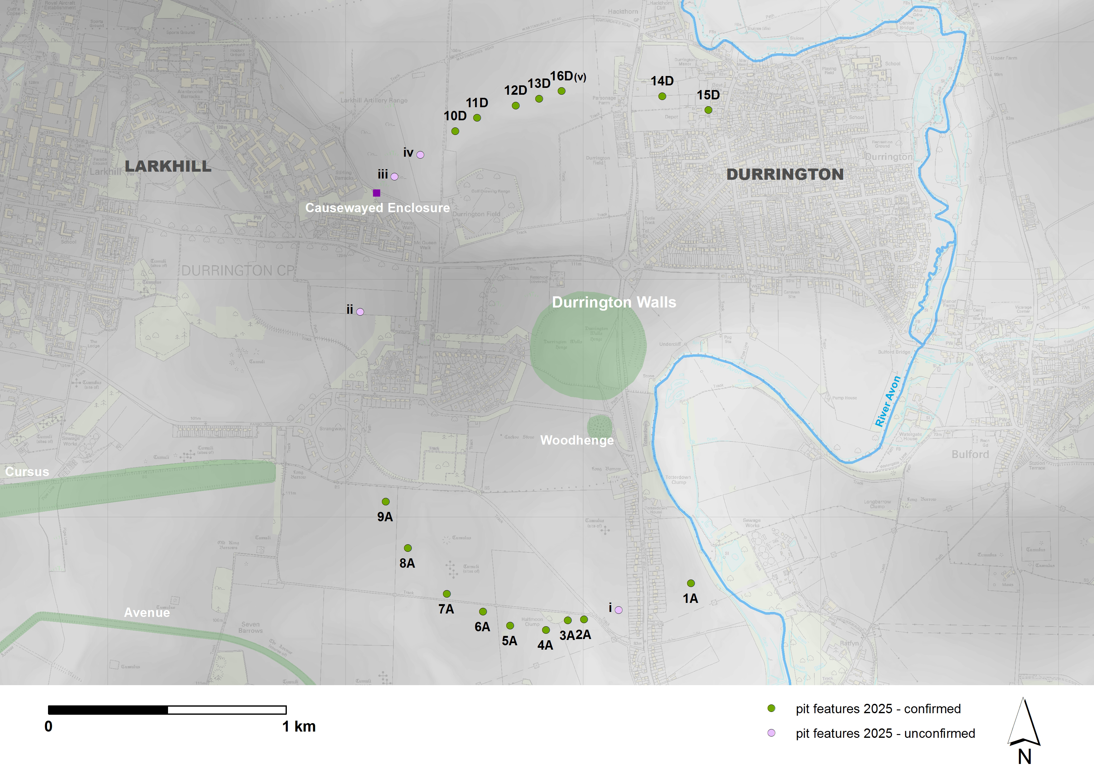