Cite this as: Savine, B. et al. 2026 Archaeological Excavations at the North Annexe, York Guildhall, Internet Archaeology 71. https://doi.org/10.11141/ia.71.10
Between 2018 and 2020, York Archaeology (YA, formerly York Archaeological Trust) undertook archaeological works at York Guildhall on behalf of City of York Council (CYC). These works provided an opportunity to gain insight into an area of Roman York between the Roman fort and the river, which developed into the principal part of the Roman civilian settlement. Due to its location, the site also shed further light on the foundation and development of the Augustinian friary formerly present in this area, from its foundation to the Dissolution.
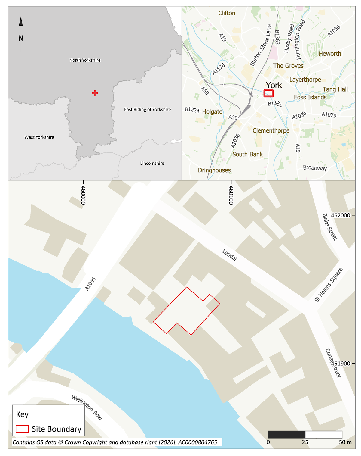
The works were conducted as part of a wide-ranging programme of refurbishment and redevelopment of York Guildhall (Figure 1), including the creation of conference rooms, meeting rooms and offices, plus a new extension added onto the north side of the complex. Planning permission was granted in 2016.
An initial phase of ground investigation commissioned by CYC comprised an evaluation undertaken by AOC Archaeology Group in 2014 at the 'Hutments' site which lay immediately to the north-west of the North Annexe. Ultimately this part of the development site would evolve into Excavation Area 1. Designed from inception as a community engagement project, the evaluation saw a reduction in ground level by approximately 1.2m across that part of the site, removing largely late medieval and post-medieval levelling deposits which were found to overlie medieval walls in two 1 x 1m, 0.8m deep test pits (AOC 2015; HER MYO2393). In 2016, AOC Archaeology also carried out monitoring on ground investigation works, including test pits and boreholes at the former Hutments site and a corridor of open space between the south-eastern side of the 15th century Guildhall building and the Guildhall's 19th century South Range (AOC 2016a; 2016b).
YA began its involvement with the project in 2018 with excavation for a lift pit sited in the southern end of the North Annexe, and a watching brief on engineering pits within the same building and adjacent external spaces (Coates et al. 2020, iii and 23–6). These works were carried out on the basis of a Project Proposal Submission by YA issued in 2017 (Reeves and Milsted 2017), setting out an archaeological mitigation methodology for the site based on a brief supplied by CYC.
YA continued as the sole archaeological contractor for the remaining phases of archaeological mitigation. During 2019 and 2020 a watching brief was maintained on a variety of ground and structural investigations, including demolition of part of the North Annexe building, underpinning of the riverside tower, ground reduction and other ancillary works, such as a crane pit (Coates 2020, 1–3).
Whilst monitoring the removal of deep brick foundations of the North Annexe building, three disturbed graves were identified, and earlier archaeological deposits below them were also exposed. The remains constituted a possible graveyard which lay approximately 150mm below the maximum construction formation depth, a thickness of cover that would not provide an adequate buffer to safely preserve the remains in situ. The programme of archaeological monitoring had resulted in a better understanding of the extent and character of archaeological deposits, consequently the risk posed to them by the proposed piling plan and foundation layout required revision to the archaeological mitigation strategy, and for that reason an update to the Project Proposal Submission and Written Scheme of Investigation (WSI) became a necessity (Milsted 2020). Accordingly, provision was to be made to meet five fundamental requirements:
After consultation with the City Archaeologist, Claire MacRae, a full excavation was carried out to identify the extent of the cemetery and any other significant archaeology in what was to become Excavation Area 1. The next phase of mitigation began in May 2020 with an ambitious three-week programme of excavation intended to meet the first three of these targets in Excavation Area 1.
The fieldwork element of the fourth requirement was met through the monitoring of boreholes and pile excavation during July and August 2020. During this time the monitoring of other elements of the foundation excavation and ground reduction, associated with the site drainage strategy, continued. Where significant archaeological deposits were encountered by the monitoring they were recorded as North Annexe Watching Brief (NA WB) 1–11.
A major portion of the ongoing watching brief was concentrated in the north-eastern end of the North Annexe building, where drains and manholes were to be installed close to foundations for a new chimney stack. The depth of excavation required for these elements ultimately resulted in a six-week programme of excavation during October and November 2020, together becoming Excavation Area 2.
To summarise, the character and quality of the archaeological record present at the Guildhall North Annexe was significantly more intact, complex and closer to the impact zone of the development (the new build elements of the project in particular) than had been suggested by either the evaluation or early phases of mitigation.
The Guildhall lies between Lendal, St Helen's Square and the River Ouse. The site is a roughly U-shaped plot of land located 0.36km south-west of York Minster. It is bounded to the south-west by the River Ouse and the York Boat mooring, and by mainly commercial properties to the north-west and north-east. An area of open ground currently used as a terrace for adjacent bars lies to the south-east. The site can be accessed from two covered passageways running south-west from Lendal and St Helen's Square. The footprint of the site is roughly 0.3ha.
The site of the Guildhall complex and immediate surroundings is roughly level at between 10.44m AOD and 11.31m AOD (Above Ordnance Datum). However, within the extent of the North Annexe site, a borehole survey had revealed that the natural ground surface slopes steeply downwards from Lendal to the River Ouse. Here the top of the glacial till falls from 7.27m to 2.2m AOD from north-east to south-west (Jackson-Slater and Krawiec 2020, iii). Therefore, the Guildhall buildings have clearly been constructed on artificially raised and levelled ground. The ground level on Lendal is about 14.3m AOD and the mean summer river level of the Ouse is 5m AOD.
The underlying solid geology for the site is the Sherwood Sandstone Group. The superficial geology immediately adjacent to the River Ouse is alluvium, whilst further up the slope it consists of clay and silt deposits of the Alne Glaciolacustrine Formation (British Geological Survey).
The chronological sequence of the Guildhall and its later ancillary buildings are relatively well understood. In recent years this knowledge has been significantly expanded through a number of physical investigations at York Guildhall during the course of renovation work, and into other sites nearby. These are summarised in Table 1 below.
| Site Name | Date of Work | Location (NGR) | Details | References |
|---|---|---|---|---|
| Excavations at Guildhall Yard | 2012 | SE 6012 5191 | Three small trenches, Trench 1 in the Mansion House cellar, Trench 2 in Common Hall Lane and Trench 3 Guildhall Yard. Possible early cobble surface, potentially Royal Commission Roman Road 10, at 11.21m AOD in Trench 1. Cellar wall and blocked doorway of the mid-15th century Guildhall overlying footings of earlier structure in Trench 2, potentially belonging to the 13th century Guildhall. 12th–13th century sediments below probable 15th and 17th century structural remains in Trench 3. | Whyman 2012 EYO6016 SYO2830 |
| The Hutments Site, The Guildhall, York Evaluation | 2014 | SE 6006 5193 | Two trenches and two test pits. Possible medieval masonry walls at 8.72–9.89m AOD, post-medieval horticultural features at 10.29m AOD, and a rubble pathway at 10.08m AOD. Five boreholes demonstrate the north-east to south-west downward slope of natural geological deposits. These were overlaid by alluvium and made ground, with organic material present in places. | AOC Archaeology 2015 EYO5577 SYO1538 AOC Archaeology 2016a EYO6255 SYO1856 |
| The Guildhall, York, Ground Investigation | 2016 | SE 6006 5190 | Three boreholes on the ‘Hutments’ site revealing a sequence of silts and clays, some containing anthropogenic material, above natural geological deposits. Two boreholes next to the Guildhall South Range revealing natural geological deposits, followed by alluvium with an organic component and 10th/early 11th century pottery at 5.12–6.42m AOD, sealed by made-ground. Three test pits, one against the North Annexe Tower and two next to the Guildhall South Range revealed post-medieval made ground. | AOC Archaeology 2016b EYO6255 SYO1857 |
| York Mansion House | February to July 2016 | SE 6013 5191 | A watching brief conducted during underpinning of basement walls. A sequence of Roman road surfaces, identified at 10.6–11m AOD, cut by a large pit from which 9th/10th century pottery was recovered. | Kendall and Savine 2016 EYO6304 SYO1896 |
| City of York Guildhall Watching Brief and Excavation | January 2018 | SE 6005 5193 | Lift Pit trench in south-west end of the Guildhall North Annexe. Post-medieval deposits potentially linked with horticultural or garden activities present at 10.08m AOD. Disarticulated human bone found alongside late 17th/early 18th century pottery. 13 engineering pits. Post-medieval made ground observed to around 7.75m AOD. | Coates et al. 2020 EYO7786 SYO2502 |
| City of York Guildhall Watching Brief | September 2019 to April 2020 | SE 6012 5191 | A watching brief conducted during demolition of the Guildhall North Annexe, underpinning of the North Annex Tower, excavation of a crane-base pit and other ancillary works. Post-medieval made ground relating to landscaping and garden activity was seen in the majority of interventions. Pilling works in the Guildhall South Range exposed naturally occurring clay at 9.21m AOD. Roman deposits containing 2nd–4th century pottery were present, including two phases of cobble surface at 9.66m and 9.82m AOD. | Coates 2020 EYO7811 SYO2567 |
| Former Post Office, 22 Lendal | July to August 2021 | SE 6012 5191 | A watching brief on site investigation works in the basement of the former Post Office building. Archaeological deposits retrieved from boreholes were recorded at depths far in excess of comparable deposits seen elsewhere in the locality. It appears likely that boreholes were sunk into deep intrusive features, probably wells, as suggested by the presence of poorly differentiated silty clays containing a range of building debris, which were several meters thick, and in WS02 the recovery of well-preserved timber intermittently from -0.4–5.18m AOD. | Karwiec and Loffman 2022 EYO7974 SYO2866 |
The current site lies on a slightly elevated plain on the north-east bank of the River Ouse, at a point at which the river cuts across the York moraine. Here the superficial geological deposits predominately comprise clay, which has been suggested to have been unsuitable for early arable agriculture (Ottaway 2011a, 113–17). Nonetheless, evidence for a Late Iron Age/Romano-British agricultural landscape around York has begun to emerge in recent years, for example at Wetherby Road Roundabout in 2018 (Savine and Coates 2023; 2026) and land off Boroughbridge Road in 2022 (Howlett 2024).
Established by the Ninth Legion on its arrival in 71 CE, the fortress at York occupied an area of approximately 20ha on the plain north-east of the River Ouse (Ottaway 2011a, 117). By 120 CE the Sixth Legion had taken over garrison duties, with York becoming the base for the Emperor Septimius Severus' campaigns in the north of Britain in early 3rd century CE (Ottaway 2011a). During this time a civilian settlement grew up around the fortress and on the south-west side of the River Ouse along the main approach road from the south. This south-western area was to grow into the principal part of the Roman civilian settlement (Ottaway 2011b, 26), which by 237 CE had acquired colonia status (Ottaway 2011b, 83).
The site is located immediately south-west of the Roman fortress defences, with the main gatehouse (porta praetoria) sited in St Helens Square. Evidence of Roman roads have been found along the Lendal/Coney Street/Spurriergate alignment in front of the fortress as well as running towards a former crossing over the Ouse under the Mansion House (Kendall and Savine 2016; Whyman 2012). The latter was represented by a sequence of road surfaces and went some way to confirming the route of RCHME-designated Road 10 (RCHME 1962, 3) at a point where the road is projected to run between the porta praetoria and the river crossing linking the fortress and the civilian settlement (Addyman 2015, Sheet F).
Possible roadside activity was found during a watching brief of piling works in the South Range in 2019-2020 (Coates 2020) and comprises a series of deposits including possible bedding layers for cobbled surfaces, from which finds including a range of 2nd to 4th century CE pottery types and a silver denarius dating to 119–22 CE was recovered.
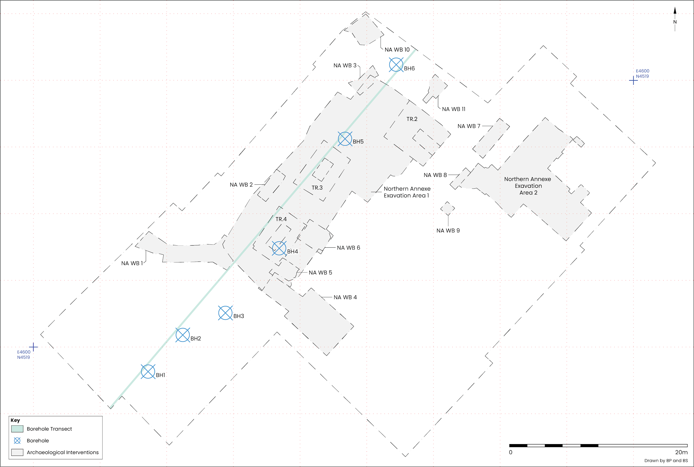
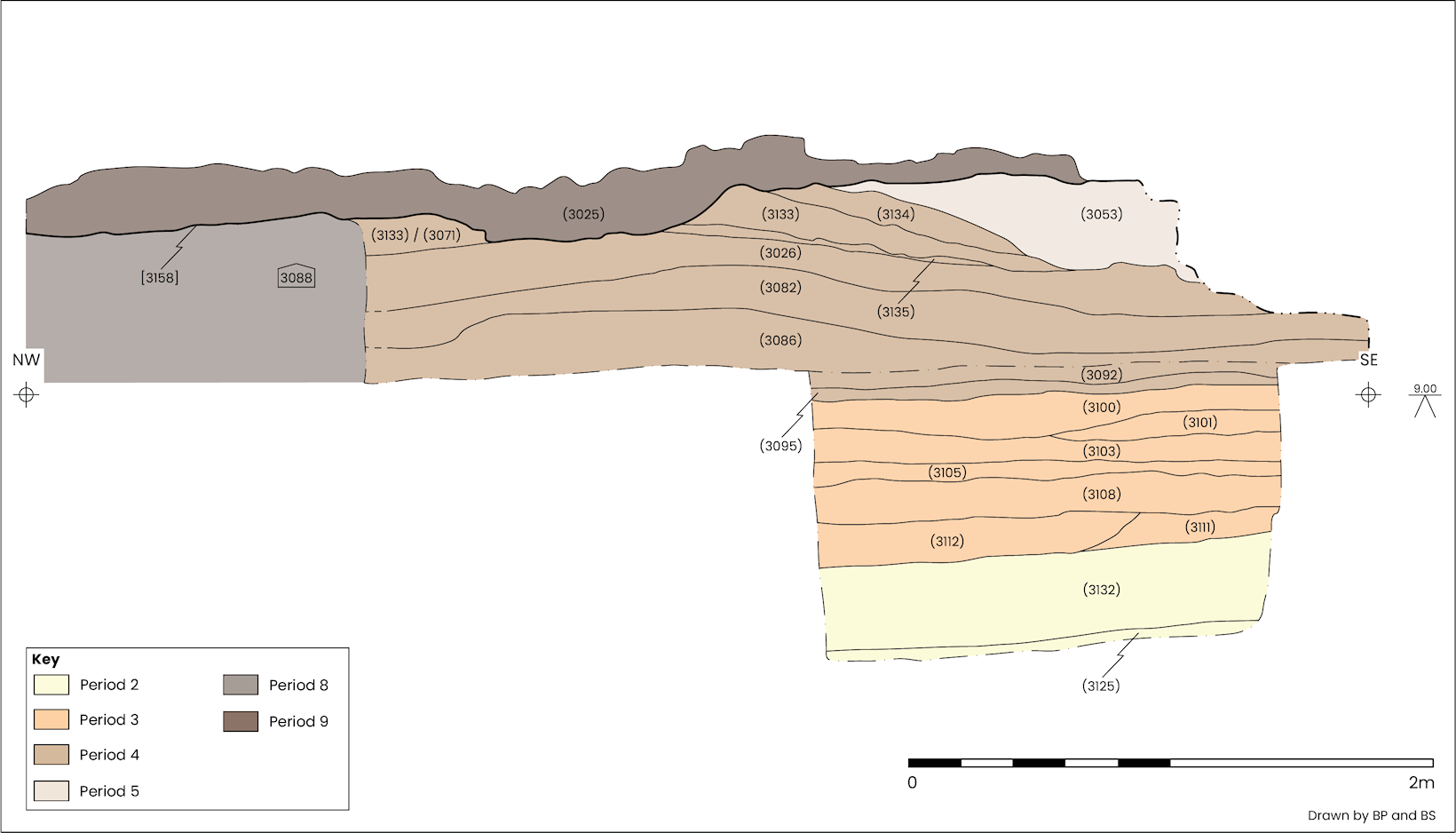
Boreholes extending through and to the south-west of Excavation Area 1 have produced a profile through archaeological horizons down to the top of naturally occurring deposits (Figure 3 and Figure 4; Jackson-Slater and Krawiec 2020), the recovery of pollen and diatoms from samples taken from borehole BH03 allow for an impression of environmental conditions close to the riverbank to be developed. The pollen assemblage is dominated by wild grasses and cereals, the cultivation of which is hinted at by the presence of taxa associated with anthropogenic activity. However, the grains were often heavily crumpled, hampering any attempt to distinguish between wild and cultivated varieties, and consequently the possibility of cereal cultivation at the site remains an intriguing but unproven possibility. Freshwater and fluctuating water table conditions appear to have been prevalent, as was waste disposal due to an abundance of parasitic worm eggs and microcharcoal in the samples. Overall, the picture is of an open landscape subject to intermittent waterlogging, and while tidal or estuarine inundation at the site appears unlikely these conditions were probably present nearby as the sediments accumulated (Hill 2022, 102–3).
The earliest reference to Coney Street (which previously extended to include Lendal and Spurriergate) dates to the mid-12th century, although it follows the earlier Roman road network and continued in use throughout the Anglian and Anglo-Scandinavian periods. It is possible that structures in the area also continued in use throughout these periods and, therefore, it was thought likely that (at the very least) small pockets of occupation from this period would be present on the site, or in the immediate vicinity.
The Augustinian Friary by J. M. McComish
Tradition suggests that that the 'Austin' friars came to York from Tickhill in the West Riding of Yorkshire, and with the aid of 'good people' were able to buy seven houses to found their friary; the houses owed rents to Lord Scrope, but he waived the rents and was therefore thought of as the father of the friary (HER MYO2393). While this tradition and the identity of the Lord Scrope in question cannot be confirmed from documentary sources, the friars were definitely present in the city by 1272 when they were given protection by Henry III (HER MYO2393; VCH 1961, 361).
The friars grew steadily; they were granted a messuage (a plot of land with its associated buildings) in 1289, the king made a gift of timber in 1292, and an additional five messuages were added between 1353 and 1359. In 1382 the friars were given a narrow plot of land near their church on Old Coney Street (now Lendal), and a further plot of land on Old Coney Street was granted in 1391 (VCH 1961, 361). In its final form the Augustinian friary covered an area of about 2 acres (Figure 2) between the River Ouse and Old Coney Street (VCH 1961, 361). It is known that there were 33 friars in 1299, 35 in 1300, 30 in 1311–2, 26 in 1319–20, between 36 and 40 in the period from 1334–7 (HER MYO2393).

Evidentially, the friary would have extended across much of the development site, with the Guildhall acting as a boundary to the south-east of the complex. The precinct would have been walled with a gateway onto Old Coney Street (VCH 1961, 361), and although little is known of the priory buildings from documentary sources, a library catalogue from 1372 lists 646 books indicates the presence of a relatively substantial library. A chapel to St Catherine was founded in the early 15th century, and it is known that Sir Humphrey Neville and his brother Charles were buried in the church following their execution in York in 1469 (HER MYO2393). Documents from the time of the Dissolution record two bells (indicating a bell tower) and that the church was roofed in lead (HER MYO2393).
The priory was surrendered to the crown in 1538, at which time it had a prior, nine priests and four novices (HER MYO2393). At the Dissolution, the site of the friary was only valued at 16d though there were also rents from houses on Coney Street, Davy Gate, Black Street, Lop Lane, Walmgate and Micklegate valued at £5 6s 8d, together with land in Oswaldkirk and Huntington valued at £2 4s a year (HER MYO2393). Clearly by the time of the Dissolution, the prohibition on friars owning property to rent out for income was no longer observed.
There was some debate at the time as to what to do with the friary. It was ruled out as a base for the Council of the North due to the presence various drains across the site, but it was recommended that stone and glass could be removed and used to renovate the Dominican friary (in the south-west of York, between the town wall and Toft Green) for occupation by the Council of the North and, although this was not approved, some of the tiles were reused in either St Thomas' or St Anthony's hospital (VCH 1961, 361). The goods of the priory were sold to Sir George Lawson for £13 14s 8d, which was used to pay off the brethren and the church plate was sent to the King's jewel house (HER MYO2393). The site remained in the hands of the Lawson family until 1568, after which time little is known about the history of the site (VCH 1961, 361).
The only previously recorded remains thought to relate to the Austin friary buildings in York was a substantial wall observed in a watching brief at the south-eastern limit of the precinct (Finlayson 1997, 490; O'Sullivan 2013, 355), while a feature to the rear of properties fronting onto the south-west side of Lendal is labelled as 'Remains of the Priory Wall' on the 1852 OS map of York . In addition, burials thought to relate to the friary were also seen in the northernmost portion of the friary precinct in an archaeological watching brief at 10–12 Lendal (YAT 1974, 17; O'Sullivan 2013, 355).
The Guildhall
A charter records the transformation in 1256 of a private hall belonging to Gerard and Hugh, sons of Lefwin, into the common civic hall, although it was not until 1378 that it was sufficiently described to identify it as being located on the current site (VCH 1961, 542). The Guildhall was rebuilt in the mid-15th century. During excavations on the site in 2012 (Whyman 2012), more than one phase of construction was present, of which the earliest predated the standing Guildhall and were of notably higher-quality stonework than the coarsely built footings above it. The coarsely built footings support the Common Hall Lane archway, the blocked cellar door and an arcade pier which belong to the 1440s building. However, the superior quality of the earlier masonry exposed in the lower part of the trench suggests that it stood at a point above the contemporary ground surface, rather than forming a part of a building's foundations. As such, it is conceivable that these represent part of the earlier Guildhall building.
The same excavations also found two substantial stone-built walls running parallel to the front of the Guildhall (Whyman 2012). The masonry of the wall farthest from the Guildhall was bonded with mortar and was at a level close to that of the threshold of the Guildhall's main door. These structures could have represented other buildings potentially associated with the Guildhall. Located near the front of the Guildhall, it is probable that the walls belong to one of two buildings documented as being built in conjunction with the mid-15th century Guildhall: a chapel and a maison dieu. Other buildings that may have been present are mentioned in the agreement between the corporation and St Christopher's Guild to share the costs of the 'new' 15th century hall, including a pantry and buttery, although it is unlikely that these would have been constructed in such a prominent position. Possible medieval walls were also found in the 2014 evaluation by AOC Archaeology (2015) at the former Hutments site, adjacent to the north-western side of the Guildhall North Annexe, centred at NGR SE 6008 5191.
After the reduction of the Augustinian friary buildings in the North Annexe area, much of the site became open ground. The Guildhall building itself continued in use with alterations and adaptation of the building and its surroundings as required.
Construction of the Mansion House started in 1726 and involved the demolition and removal of structures to the north-east, between the Guildhall building and St Helen's Square. The 18th century is also when many of the standing buildings along Lendal were constructed and, more significantly, when the gardens to the rear were landscaped, giving the layout as presented on the first edition Ordnance Survey map of 1852. Between 1889–91 a new council chamber and municipal offices were built on the north side of the Guildhall (VCH 1961 , 543).
The North Annexe was constructed in c. 1902 and the South Range c. 1904. Further structures were built in Common Hall Yard in the early 20th century.
In the second half of the 19th century, the boundary to the north-west of the site was altered and the wall rebuilt. The open space between this boundary and the North Annexe was filled by the 'Hutments' buildings in c. 1945. These were possibly built to accommodate council activities whilst repairs were underway following the April 1942 'Baedeker' bombing raid.
The findings of the archaeological investigations were considered in light of the research questions set out in the post-excavation assessment and updated project design (Savine 2022), which were established with reference to the Yorkshire Archaeological Research Framework (Roskams and Whyman 2007).
The excavation was initially carried out using an 8-tonne rubber-tracked mechanical excavator. Machine excavation ceased when significant archaeological deposits were exposed. Three 3 x 3m trenches (Trenches 2, 3 and 4) were targeted on specific areas of interest for hand excavation, situated where the piling would have the greatest impact, as agreed with the City Archaeologist. Each trench was 2.4m deep in total, which consisted of a depth of 1.2m for the full 3 x 3m area, with a further 1.2m depth in the centre over a 1 x 1m area (Figure 3).
In order to avoid impacting on archaeological deposits, where possible, pile locations were moved, and where this was not achievable the harm was mitigated via targeted excavation.
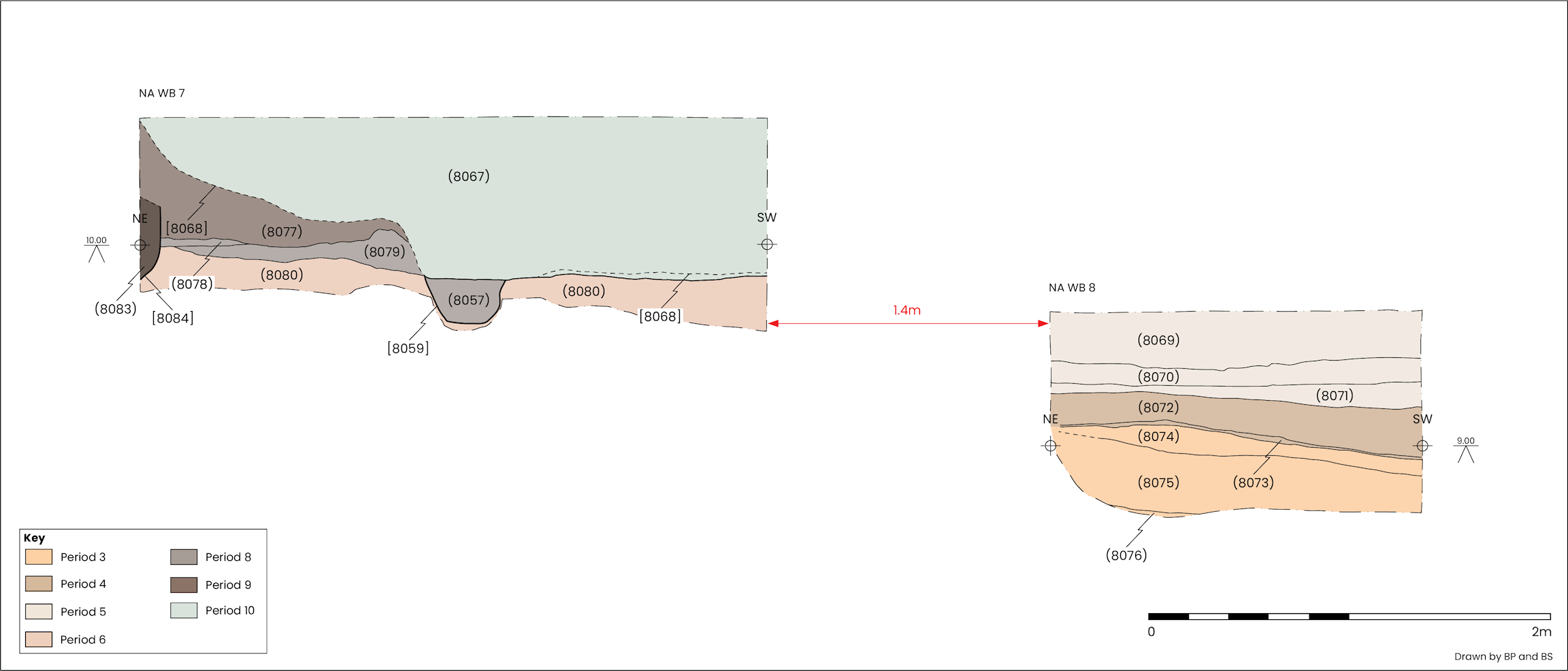
Following the conclusion of archaeological works in Excavation Area 1, a watching brief was maintained on elements of the construction program where archaeological deposits were impacted. This included the targeted reduction of the large magnesian limestone wall running through the centre of the site, additional small-scale hand excavation around pile caps and excavation relating to installation of utilities, for example drains and manholes. In total 11 discrete areas required dedicated archaeological investigation. These have been referenced as North Annexe Watching Brief (NA WB) and assigned identifying numbers 1–11 (Figure 3).
A watching brief was also carried out during the drilling of piles (Jackson-Slater and Krawiec 2020). Following the installation of a pile mat, 56 piles were sunk, 48 of which were monitored. In addition, six windowless sample boreholes were arranged across the west of the site to provide a profile through the archaeological remains to the top of the naturally occurring deposits (Figure 3).
Utility works inside the north-eastern end of the former North Annexe building involved the extension and widening of existing drains. Initial watching brief works exposed more burials and the top of what turned out to be a sequence of complex, well-stratified deposits dating to the Roman and medieval periods. This became Excavation Area 2 (Figure 3). Constraints resulting from limited access, and a large 19th/20th century drain bisecting the area, necessitated excavation in four separate parts from west to east.
The site boundary and notable features were recorded and a 5m site grid aligned to the OS using a Leica Viva GNSS-GS16 unit (accurate to 10mm).
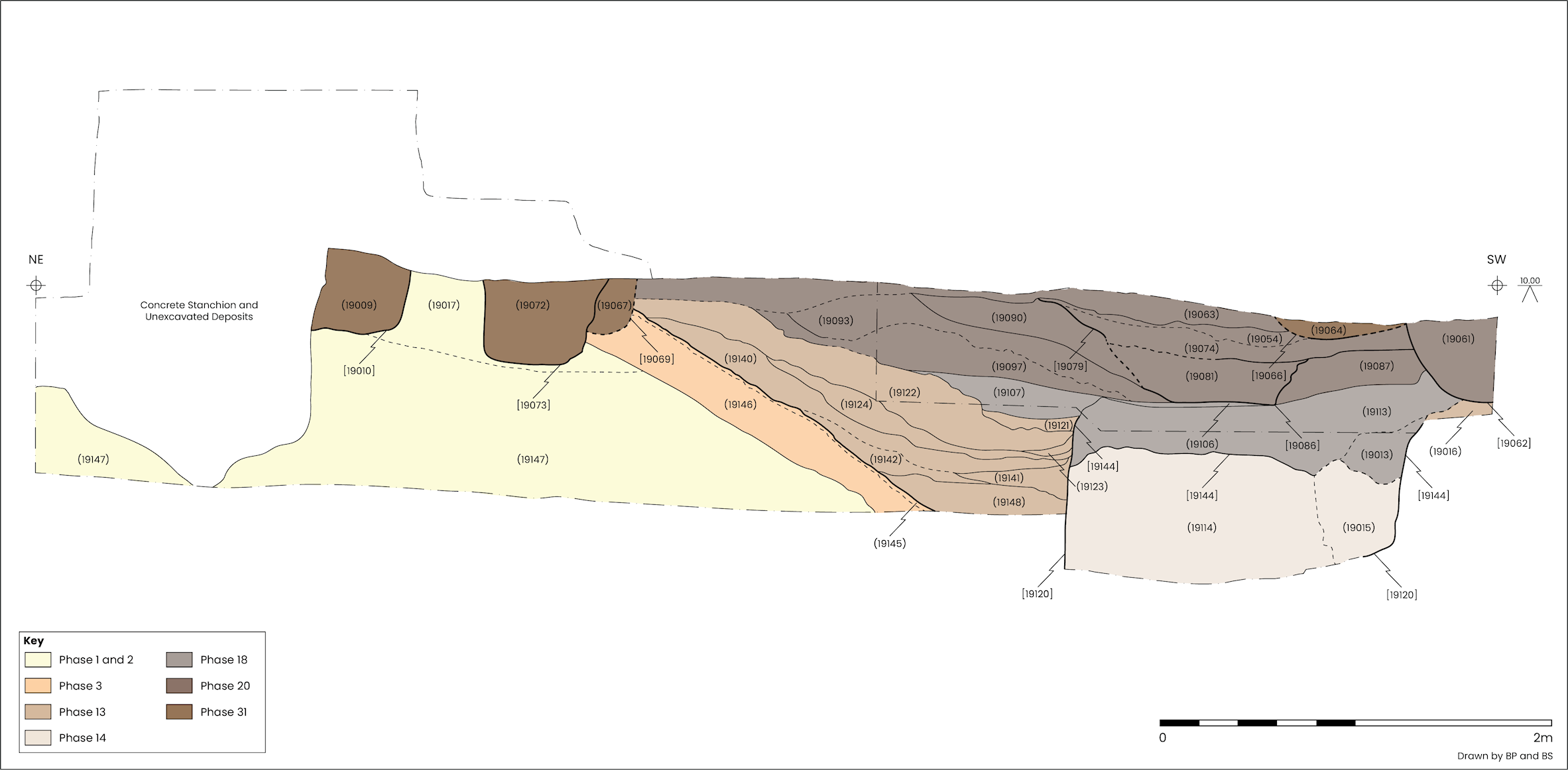
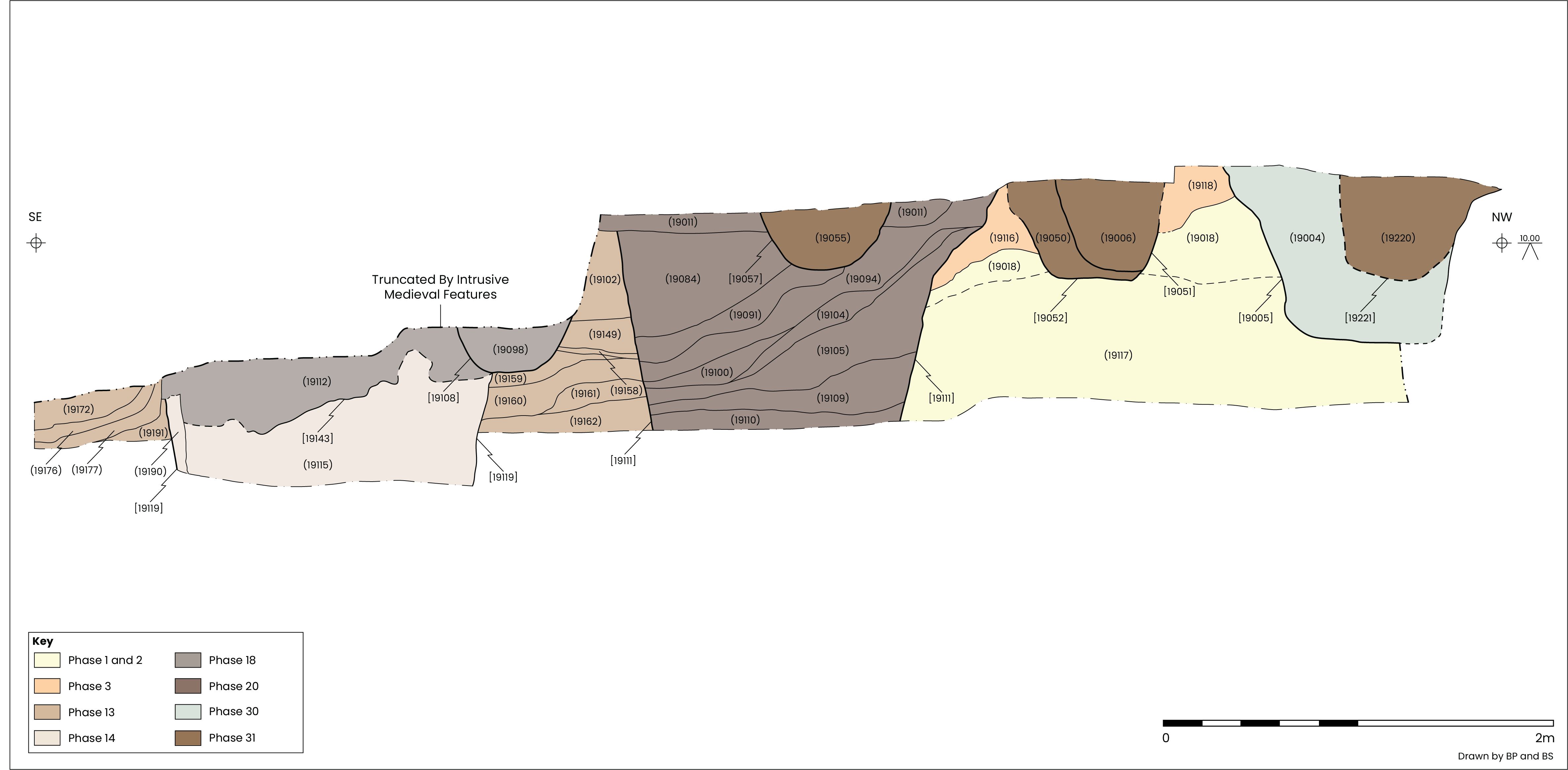
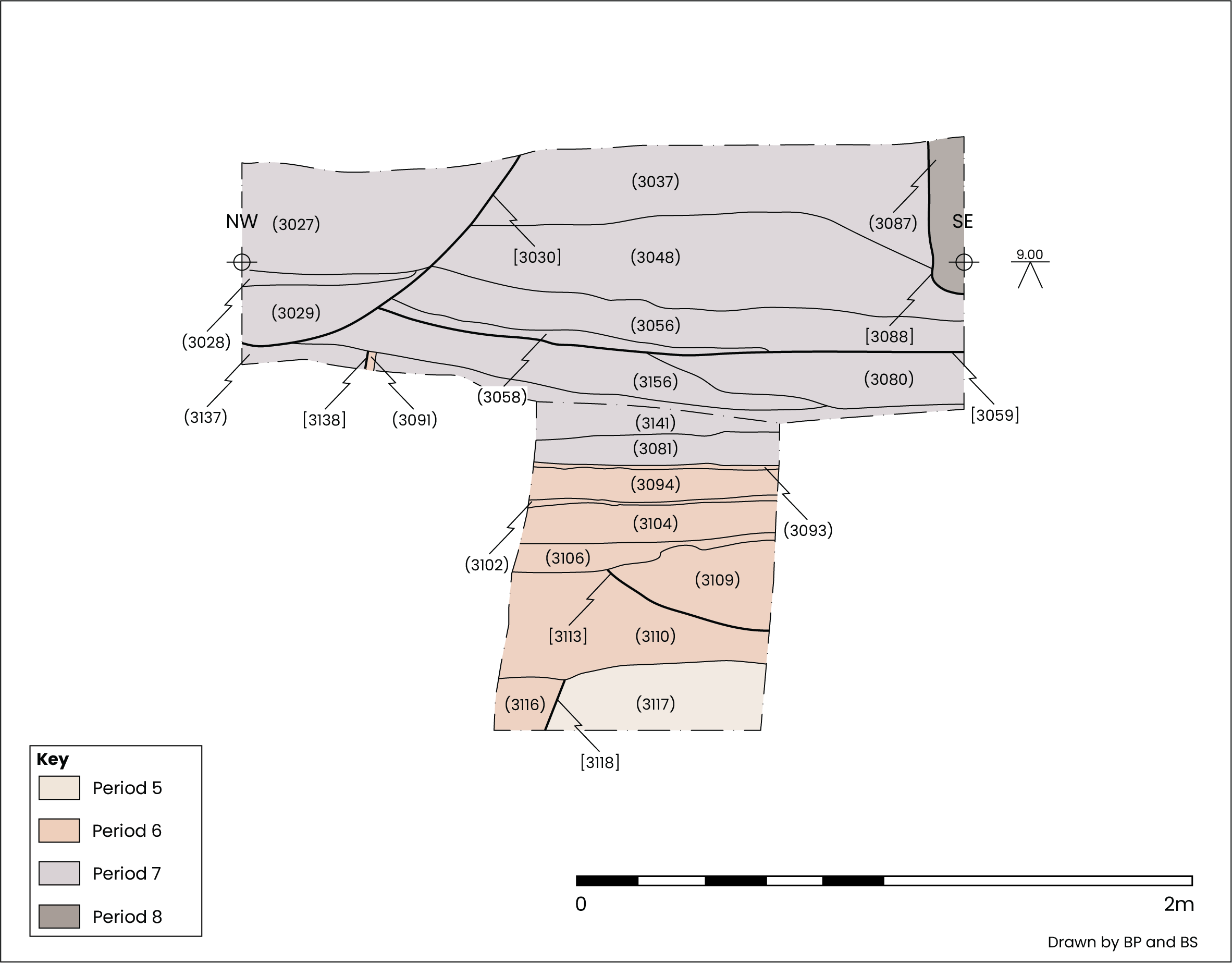
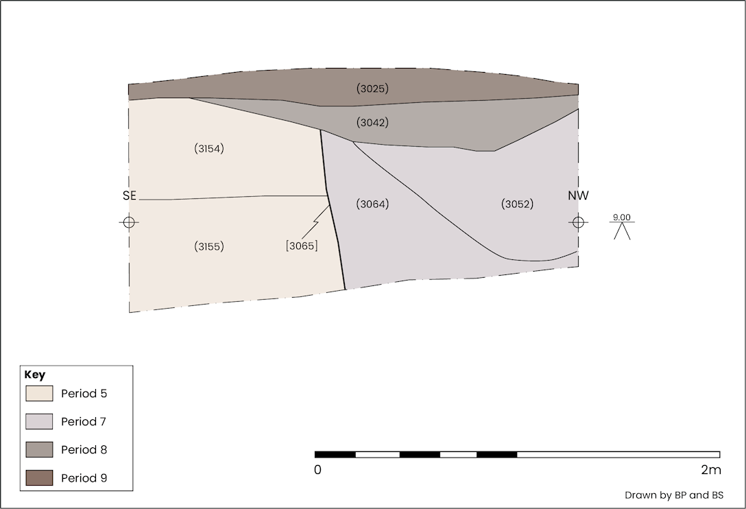
Colour digital photography was used to document archaeological contexts and to capture working shots of the excavation. Additional photographs were taken using a DSLR and a smartphone capturing images at a resolution of no less than 12 megapixels. Each context was assigned a unique four-digit context number, drawn in plan and recorded on a proforma context card. Significant features and deposits were also recorded photogrammetrically, and where possible in section (Figure 4).
Finds were retrieved and bagged by individual context number and a judgement sampling policy was followed for the retrieval of environmental samples from suitable contexts.
The structure of the results presented below is based on stratigraphic units, or Contexts, assigned during the excavations. A context represents an individual event or activity. Closely related contexts were then amalgamated into Sets, for example a foundation trench and its fills. Sets associated with related activities were then placed into Groups which were incorporated into Phases on the basis of dating. Phases represent separate and distinct activities or events. Finally, phases have been attributed to Periods, normally defined by site wide activity and based on broadly chronological periods.
Contexts, Sets, Groups and Phases are abbreviated in accordance with the following examples: C1000, S1000, G100 and P1 respectively.
The site phasing has been informed by stratigraphic, chronological and spatial information, along with data from artefactual analysis, thereby enabling Contexts to be attributed to Sets, Groups and Phases. The results of this work have been brought together and are presented by Period to explain broad stratigraphic and chronological changes in landscape use and activities that have taken place at the site.
Dating was primarily reliant on the spot dates of pottery finds. Pottery spot dates have been calculated from the latest date of the latest pottery type. Where dates are given below, they are from pottery unless otherwise stated.
The archaeological features on the site are subdivided into ten phases based on a combination of ceramic dating and stratigraphic evidence:
This volume represents a detailed analysis of the results of the archaeological investigations at the North Annexe, York Guildhall in 2020. This chapter has provided a summary of recent archaeological works undertaken in the vicinity of the Guildhall. Chapter 2 examines the evidence for Roman occupation and settlement of the site in the late 1st to early 3rd century CE, followed by the adaptation of the area in the 3rd century CE. Chapter 3 details a re-emergence of activity and occupation of the site from the late 11th to early 13th century. Chapter 4 presents evidence of the Augustinian friary, its buildings and graveyard, and their alteration in relation to expansion of the friary. Chapter 5 deals with the post-medieval and modern development of the site following the demise of the friary. Specialist artefactual, environmental and osteoarchaeological analysis are presented in Chapter 6, Chapter 7 and Chapter 8. Chapter 9 discusses the development of the site, placing the Roman occupation in relation to development of the wider roman settlement at York. Similarly, the evidence for use of the site during the medieval period is examined in reference to the archaeological and historical evidence for development of the city during the 12th and 13th centuries.
Internet Archaeology is an open access journal based in the Department of Archaeology, University of York. Except where otherwise noted, content from this work may be used under the terms of the Creative Commons Attribution 3.0 (CC BY) Unported licence, which permits unrestricted use, distribution, and reproduction in any medium, provided that attribution to the author(s), the title of the work, the Internet Archaeology journal and the relevant URL/DOI are given.
Terms and Conditions | Legal Statements | Privacy Policy | Cookies Policy | Citing Internet Archaeology
Internet Archaeology content is preserved for the long term with the Archaeology Data Service (ROR). Help sustain and support open access publication by donating to our Open Access Archaeology Fund.
 Home
Home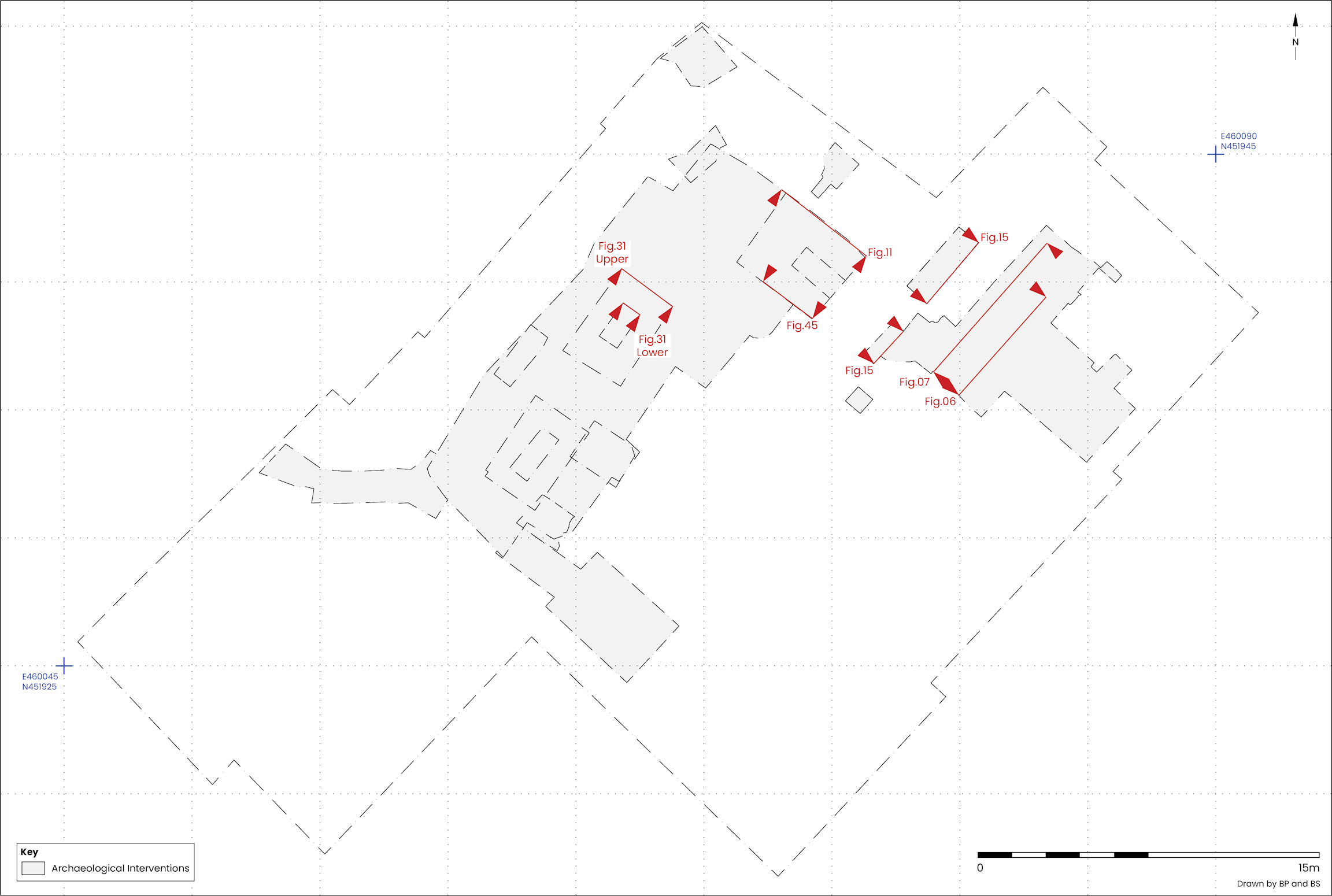