Cite this as: Savine, B. et al. 2026 Archaeological Excavations at the North Annexe, York Guildhall, Internet Archaeology 71. https://doi.org/10.11141/ia.71.10
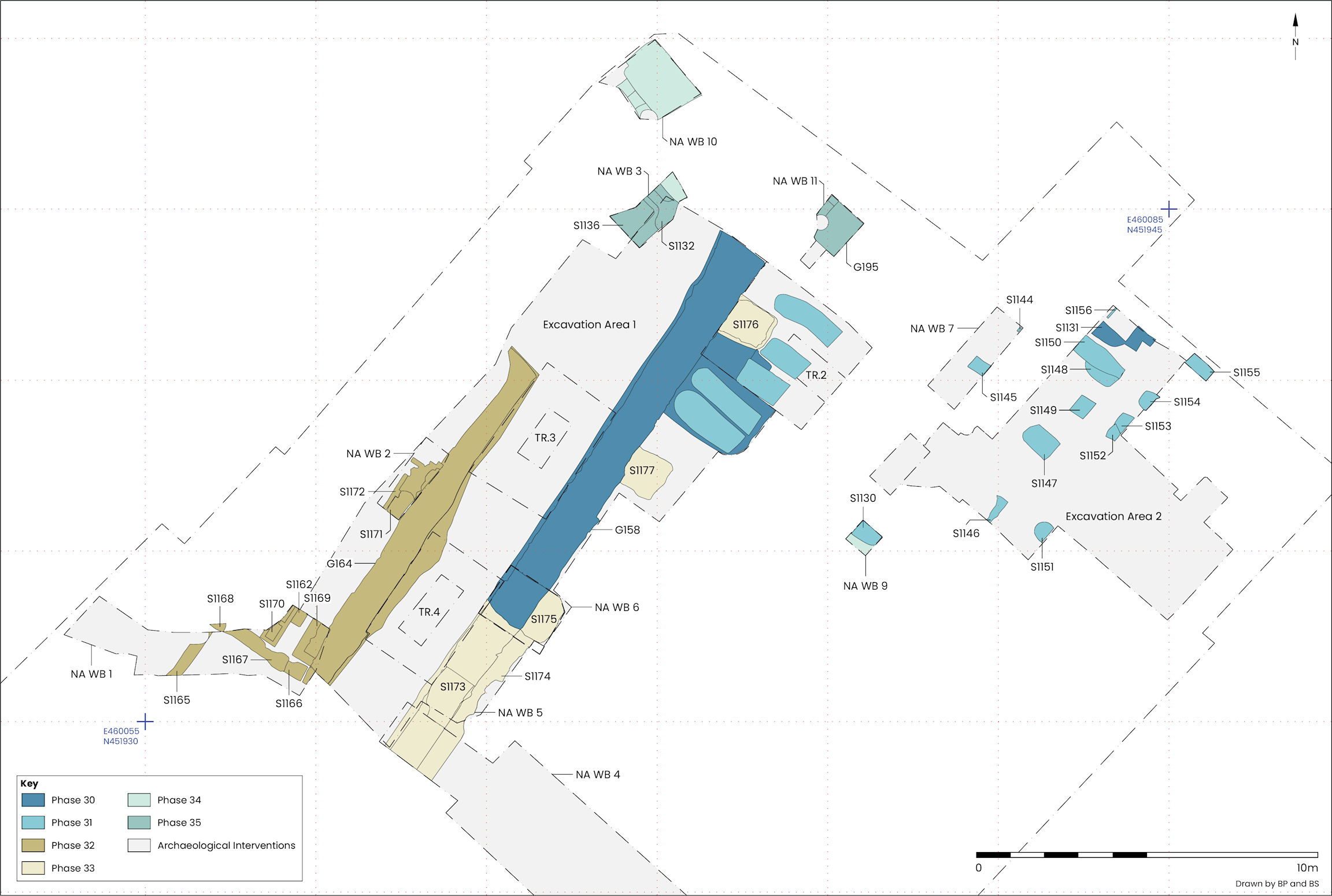
Phase 26 | Phase 27 | Phases 28-29 | Phase 30 | Phase 31 | Phases 32-33 | Phases 34-35
An Augustinian friary is known to have been established on the site by at least 1272. Evidence for this can be seen in an intensification of activity during mid-13th to mid-14th century, including landscaping, organised refuse disposal and construction of a building incorporating a large hearth in Excavation Area 1.
After the P24 mortar surface in Trench 3 fell out of use a significant elevation to the ground level above occurred. That activity extended south-west to the periphery of Trench 4 (Figure 39).
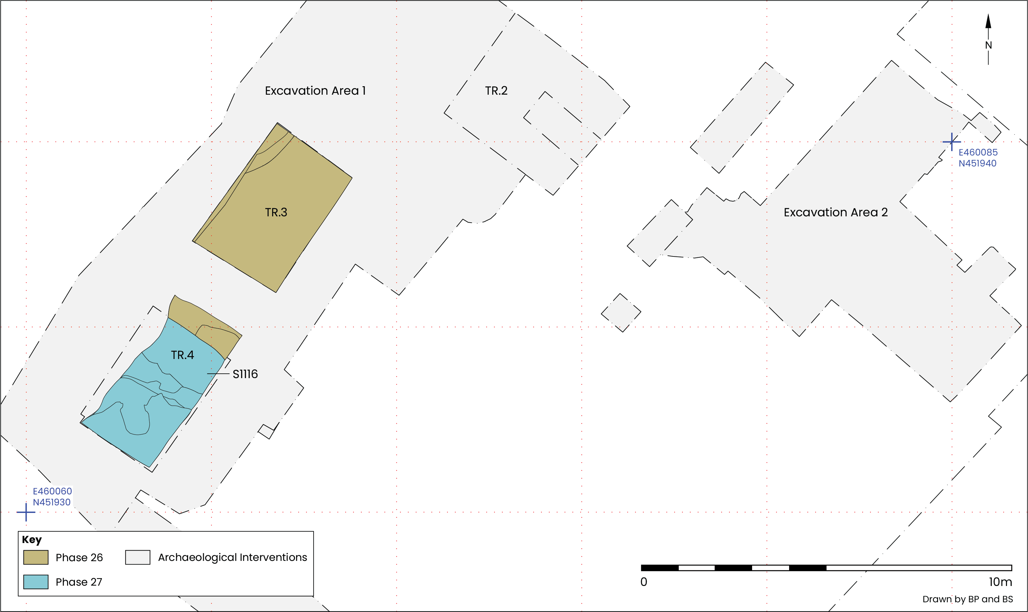
Overlying the trampled material in G146 (P24) and extending to 8.71m AOD were levelling deposits C3081 and C3141 (Figure 31). These comprised mid-orange brown sandy clays containing frequent cobbles and mortar flecks, with pottery dating to the mid-13th to mid-15th century present in C3081 (Figure 40).
Running along the full length of the north-western side of Trench 3 and cutting into a possible mortar surface C3091 (G146), was feature cut C3138. Only a narrow strip of this feature extended into Trench 3, making it difficult to interpret, but it could have been a robber cut for removing a wall up against which the mortar surface (C3091) had been laid.
A considerable rise in ground level then took place across the south-western end of Excavation Area 1, to around 9.15m AOD (Figure 41). Dumps and pits as far up as C3048, which contained domestic refuse and CBM, extended across the whole of Trench 3; some were clearly equivalent to deposits 1.43m to the south-west, along the edge of Trench 4, for example C3078. Pottery recovered from the lower deposits in this sequence dated to the 13th–15th century, while 12th–13th century pottery was recovered from stratigraphically later deposits. The latest feature attributed to this phase was a pit in Trench 4. The backfill (C3076; G148) contained early 13th to mid-14th century pottery.
Truncating the G148 pit was a probable wall robber cut (C3085; G150) relating to the demolition of a structure found in Trench 4, described below (see Phase 27). Pottery found in that feature provided a mid-13th to mid-14th century spot date, tightening the date range for the P26 activity to no later than the mid-14th century.
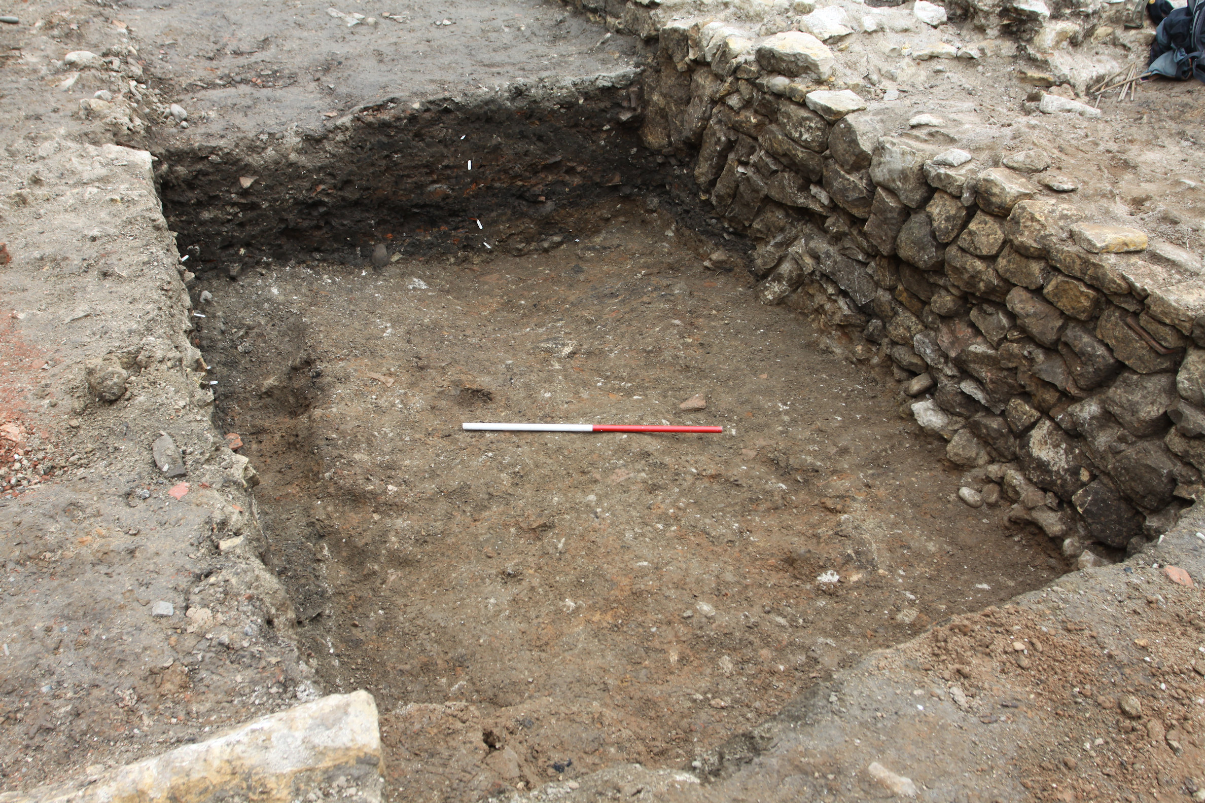
Occupying a large part of Trench 4 was an edge-set tile surface (Figure 39), a construction form typical for medieval hearths. Exposure to sustained direct heat was also evident.
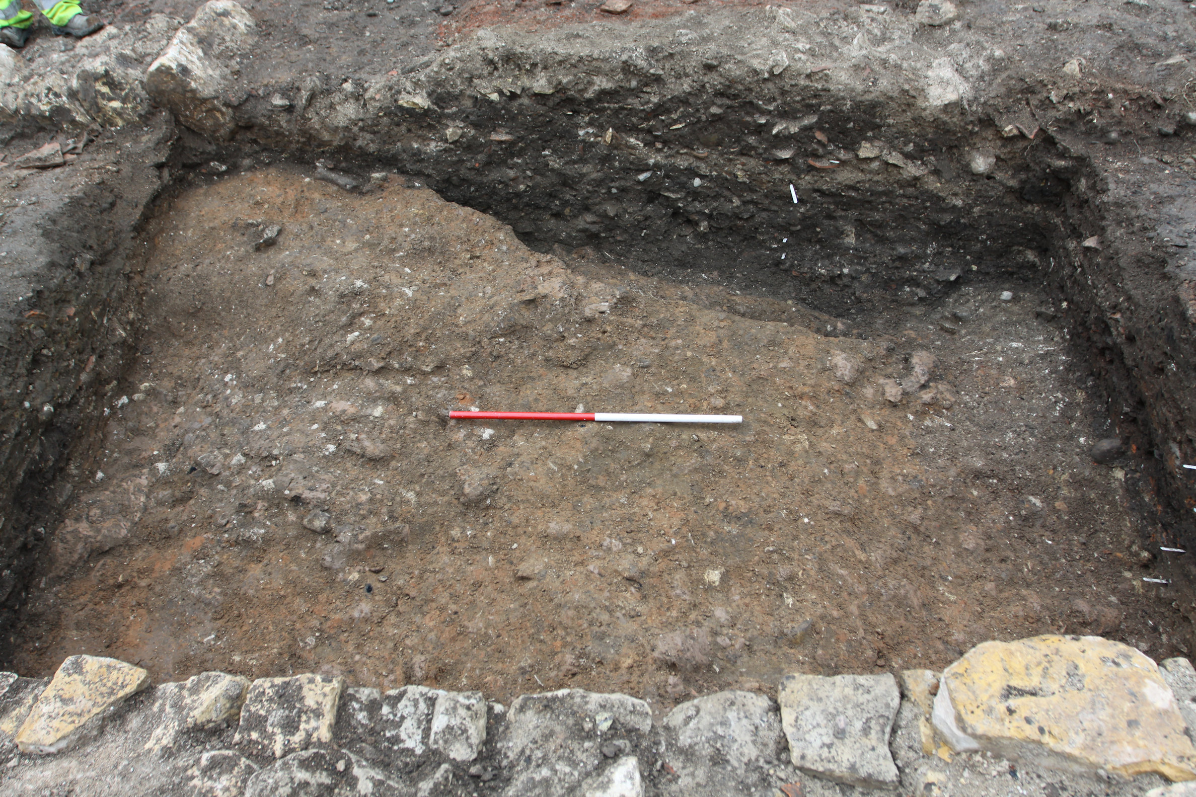
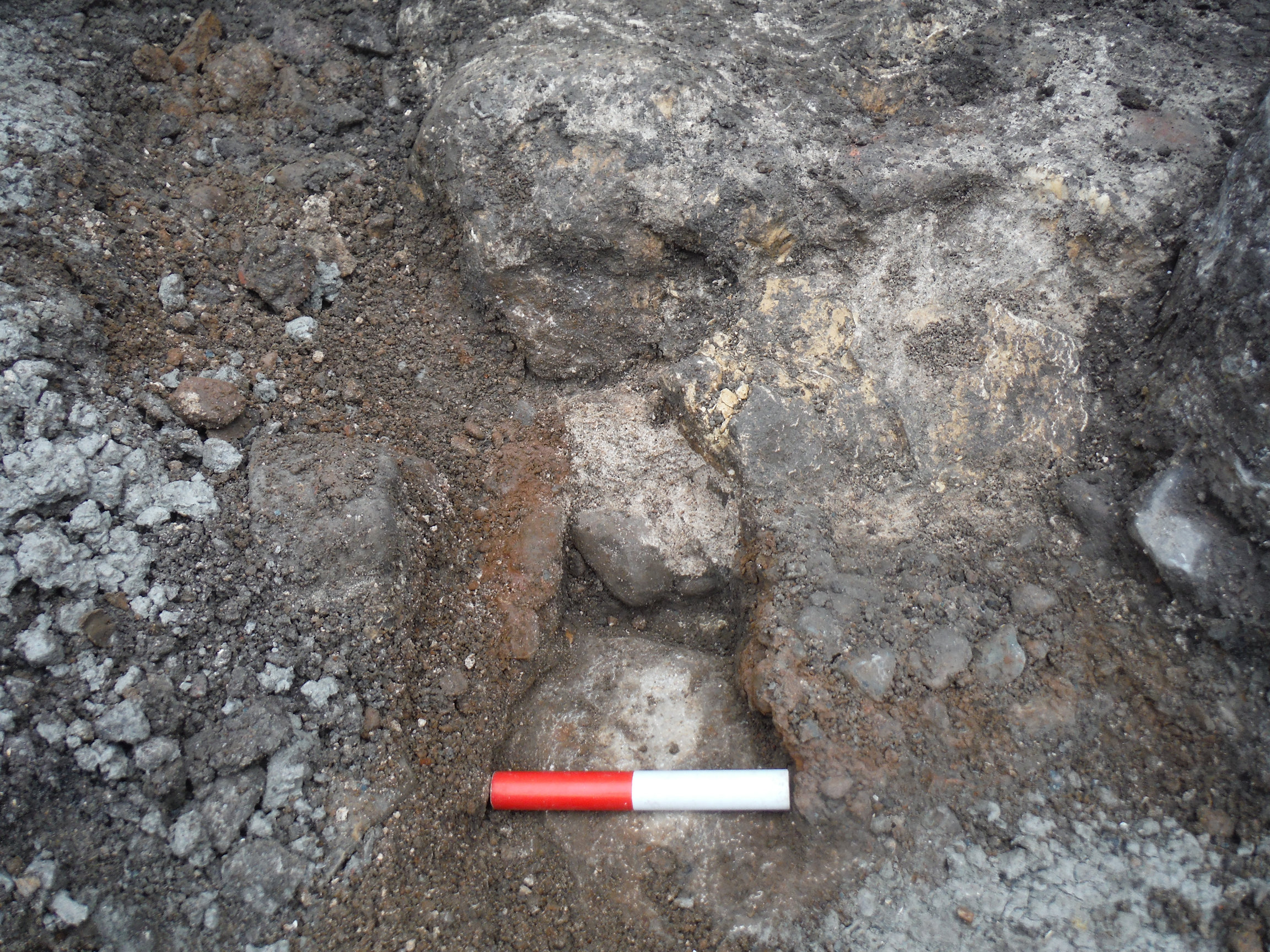
The first component of the hearth comprised limestone fragments bedded into orange-pink clay (C3114), set into a slightly deeper part of the construction cut measuring 1.52m north-west/south-east by 1.04m north-east/south-west. Intense heat appears to have been centred above, fracturing the stone and causing scorching to radiate further out (Figure 42). Fragments of 13th century pottery and 14th–16th century CBM were recovered.
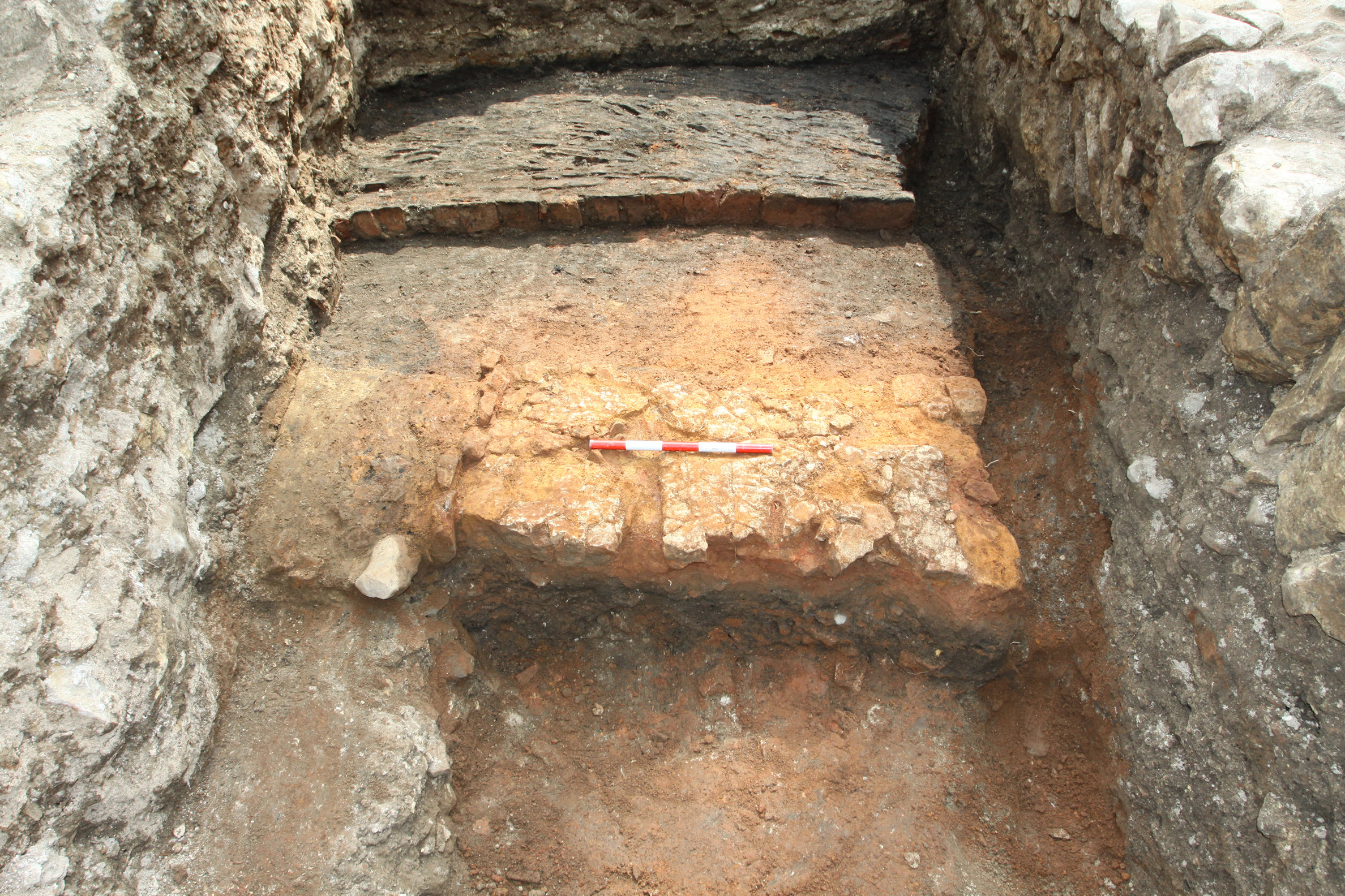
Above the limestone was an edge-set tile surface measuring 2.51m north-east/south-west by 2.19m north-west/south-east at a height generally around 8.4m AOD but rising to 8.52m AOD in the eastern corner. The tiles dated to the 13th–16th century and a few sherds of mid-13th to mid-14th century pottery were also present. The surface continued beyond the south-western end of the trench, was truncated by a later wall to the north-west and a linear cut to the north-east and was then either cut or overlain by a later wall to the south-east. No other structural elements were found, but the layout maintained the same alignment established by earlier activity.
Two distinct areas of tiling were identified (Figure 43). To the north-east, directly above the limestone, was C3107. Here the tiles were mostly aligned north-east/south-west and scorching was apparent on the surface. Close to the eastern corner was an area, approximately 0.3m², where tiles had been set into a square pattern, possibly as part of a repair or a socket designed to hold a component of a surrounding or associated structure. To the south-west the tiles (C3099) continued at the same height but were arranged perpendicular to those in C3107. Although some burnt debris covered this part of the surface there was no scorching.
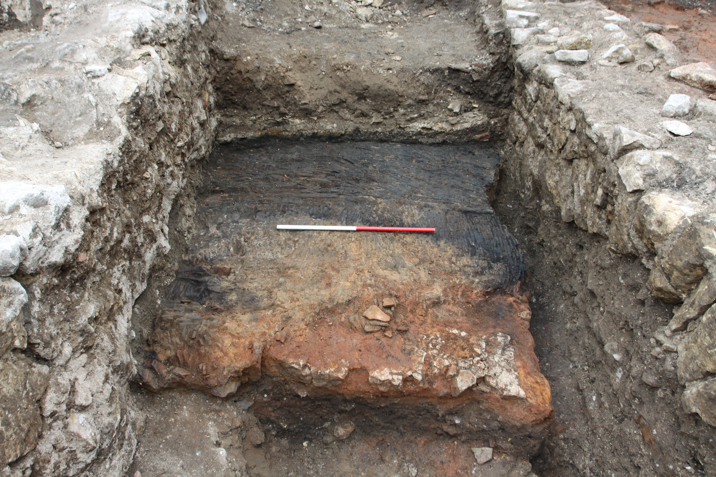
The hearth appears to have been well maintained and kept clean; only a thin friable, dark grey-black, silty clay containing frequent flecks and fragments of charcoal covered the surfaces. This deposit (C3098) was probably residue from the last use of the hearth.
Little evidence for demolition of the structure around the hearth was present, however, a thin layer of mortar (C3096), dating to the mid-14th to mid-15th century and perhaps derived from demolition activity, covered C3098, and a possible robber cut situated along the north-eastern edge of the hearth may have removed a wall there. This linear feature (S1116) extended the full width of Trench 4 on a north-west/south-east alignment and measured 1.37m across and 0.77m deep (Figure 39). Mid-13th to mid-14th century pottery was recovered from the fill.
The scale of the building that stood in Trench 4 during the 13th and 14th centuries is demonstrated by the size of the hearth and robber cut along its north-eastern edge, while some indication of its setting is provided by the 0.75m step down in height from the ground immediately to the north-east and the comparatively low level the hearth was present at. Construction of the building represents the first large-scale medieval occupational presence on the site. It appears to have been built no earlier than the mid-13th century and to have remained in use up until the mid-14th century, its dates corresponding with the establishment of the Augustinian friary (VCH 1961, 361).
Following demolition of the building in Trench 4 the ground level was raised, bringing it closer to that in Trench 3. Landscaping activity was then followed by the digging of large refuse pits.
At up to 0.4m thick C3070 was the most substantial of the levelling deposits in Trench 4 (Figure 44). It comprised friable, light brown, silty sand. No datable material was recovered from C3070 but late 11th to mid-12th century pottery and 13th–16th century CBM was present in subsequent levelling deposits (C3068 and C3074). The levelling activity increased the ground level in Trench 4 by around 0.65m to 9.12m AOD.
Similar friable brown sandy silts were also present across all of Trench 3 (Figure 39). Here C3037 extended to 9.3m AOD (Figure 31) and some 12th to mid-14th century pottery was recovered from it, together with a large volume of Roman pottery.
Considerable elevation of the ground level across the south-western end of Excavation Area 1 followed the demolition of the P27 building in Trench 4. The friable character of the levelling material suggests that it was deposited reasonably rapidly with little regard taken to compacting it well. In addition, the landscaping activity appears to have been extensive, measuring at least 9.63m north-east/south-west and, given the volume of residual artefacts present, included either material imported from elsewhere in the town or excavated from some depth from another part of the site. Digging building foundations could generate large quantities of material, however this kind of activity does not appear to have immediately followed in this part of the friary precinct.
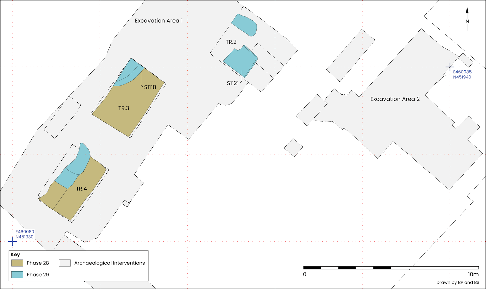
Large refuse pits (five in total) were found in each of the trenches in Excavation Area 1, across an area nearly measuring 14m north-east/south-west. Pottery recovered from all of the pits provides a mid-13th to mid-14th century spot date, and was present alongside significant quantities of earlier artefacts, largely Roman pottery but also two Roman coins (SF37 and SF38) and a William I silver penny (SF41) minted at Canterbury in 1080–3 (see section 6.12; Table 33), which was found in the primary fill of pit S1118 (C3029) in Trench 3 (Figure 31, Figure 39 and Figure 44).
Of particular interest was pit S1121. This feature measured 1.5m by 1.5m and was at least 0.8m deep, although it was truncated to the north-west and south-west and the base was below the extent of excavation in this part of Trench 2 (Figure 46). The upper backfill (C3052) contained a vast quantity (774 sherds) of Splashed ware pitcher fragments. Many were wasters with some displaying glaze over the edges, as well as over-firing, glaze slag and fusing between vessels. An unusually large group of curved and flanged tile, accounting for nearly 21% of the assemblage of this type, was also present in C3052 and included many large sherds.
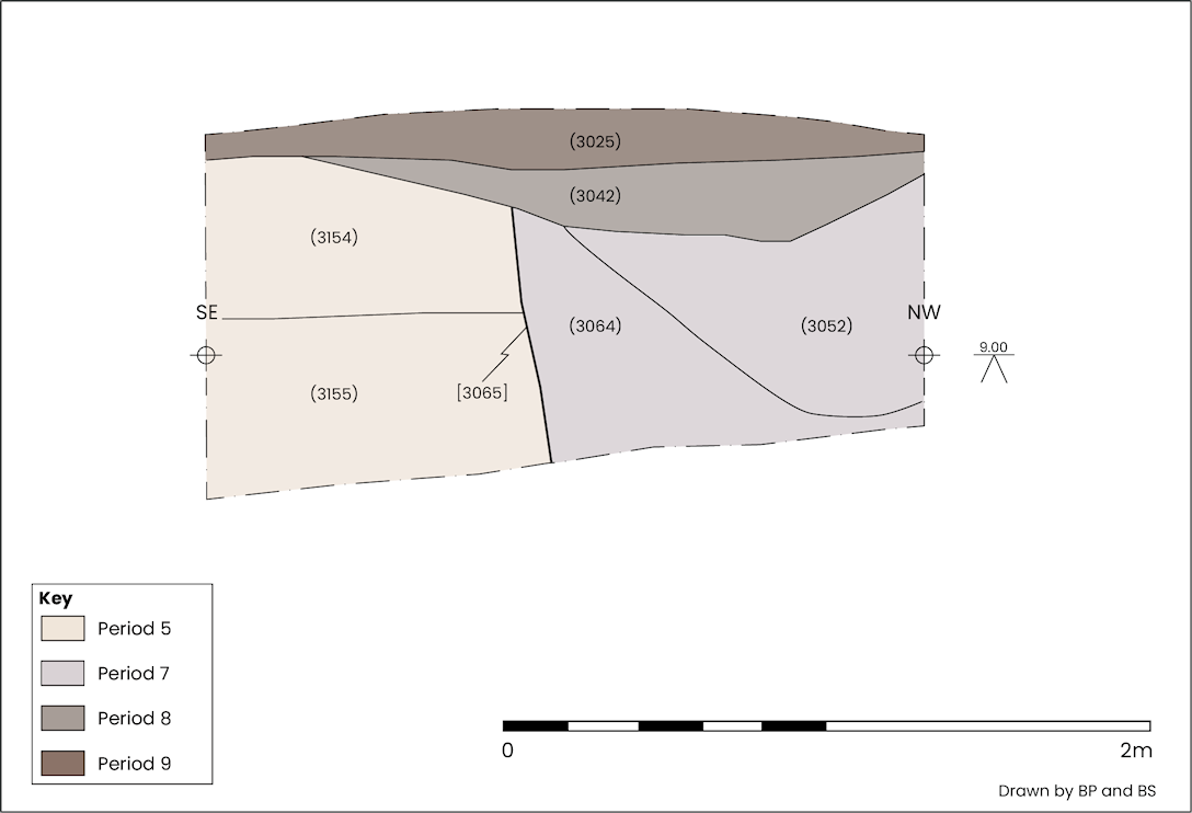
Splashed wares found in York are known to have been produced from the late 11th–13th century, with the C3052 assemblage typologically belonging to the early to mid-12th century (see section 6.2), and the presence of so many wasters might typically be considered to indicate the presence of a kiln nearby. However, chalk inclusions in the pottery fabric indicates that this material derived from a kiln, or kilns, at Beverley (see section 6.2); quite how it ended up here is uncertain. Production of curved and flanged tile encompasses a similar date range of the late 11th to early 13th century, and are a type commonly thought to be associated with high status buildings. The recovery of other, later, pottery types from the P29 pits, for example York glazed ware, Beverley ware and Brandsby ware from C3052, and C3064 lower down in the same pit (S1121), in addition to the abundance of 13th–16th century roof tile throughout the pit, could push the date for the clearance of redundant structures as late as the 14th century.
The significance of the waste materials present in C3052 lies not only in their sheer volume but also in what those material types infer about activities on the site during the 13th and 14th centuries compared to subsequent activity. What followed next may have required significant reorganisation and could have been the catalyst for the demolition of structures and raising of the ground level seen in P27–29.
Following landscaping and pit digging in Excavation Area 1 reorganisation of the site appears to have occurred. A stone wall was constructed through the middle of the site, which for the remainder of the medieval period delineated two very different zones of activity.
A possible linear feature was present at the northern end of Excavation Area 2 (C19005; S1131). Aligned north-west/south-east and measuring 1.40m long, 1.10m wide and 0.97m deep, this feature had steep sides and a flat, even base, suggesting a linear form (Figure 7 and Figure 47). Backfilling appears to have taken place in the 14th century and seems to have been a rapid process.
Preparation work for the construction of a limestone wall included stabilising the ground around the S1121 (P29) pit in Trench 2 with levelling deposits C3042 and C3049, S1123 in G154 (Figure 45).
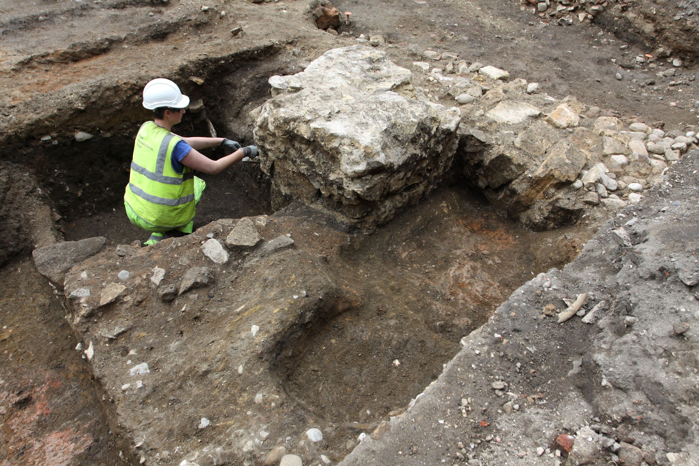
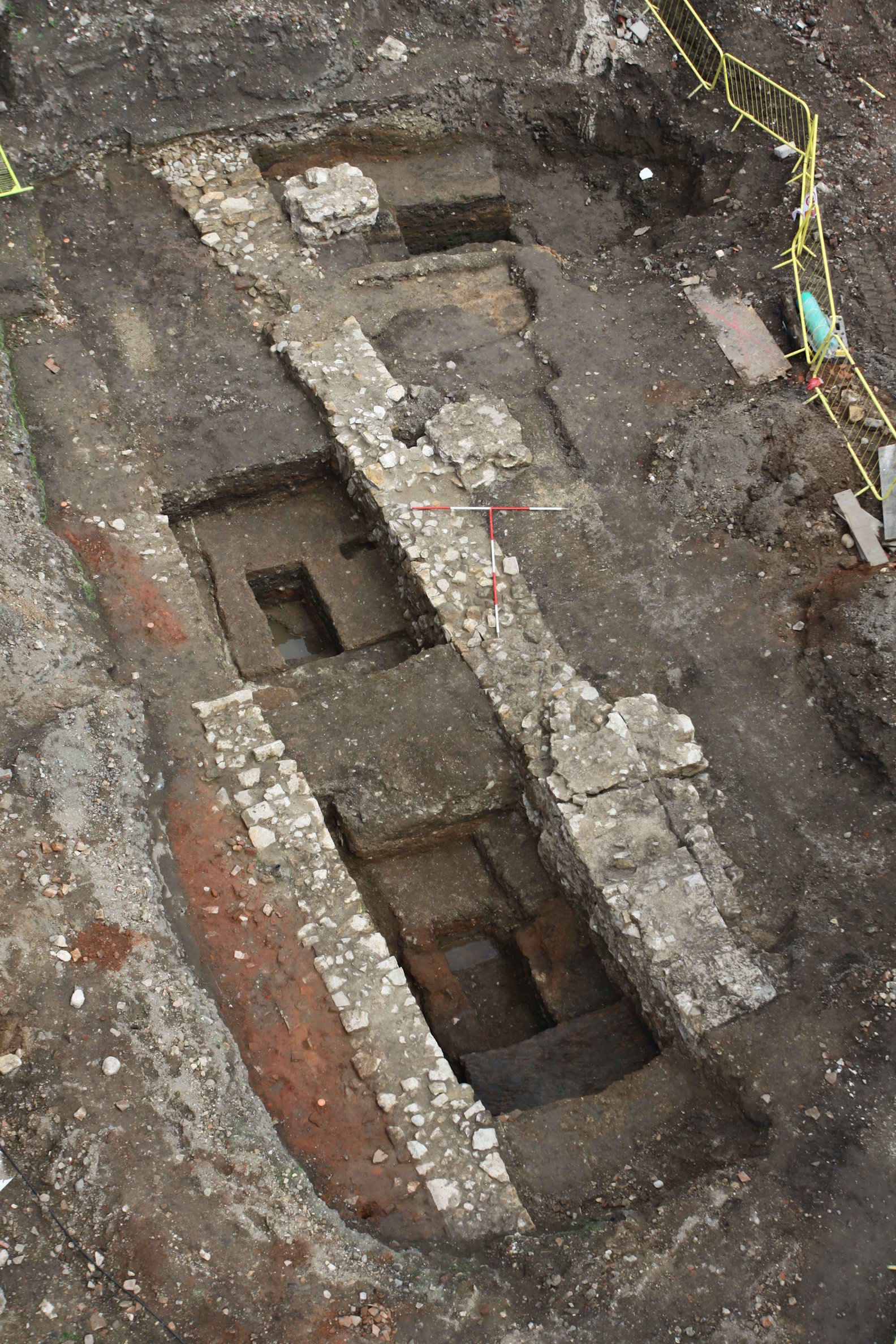
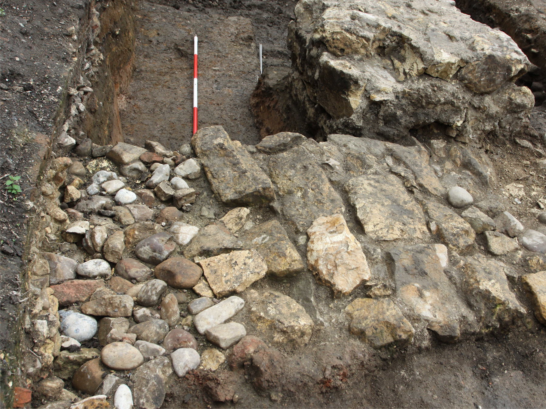
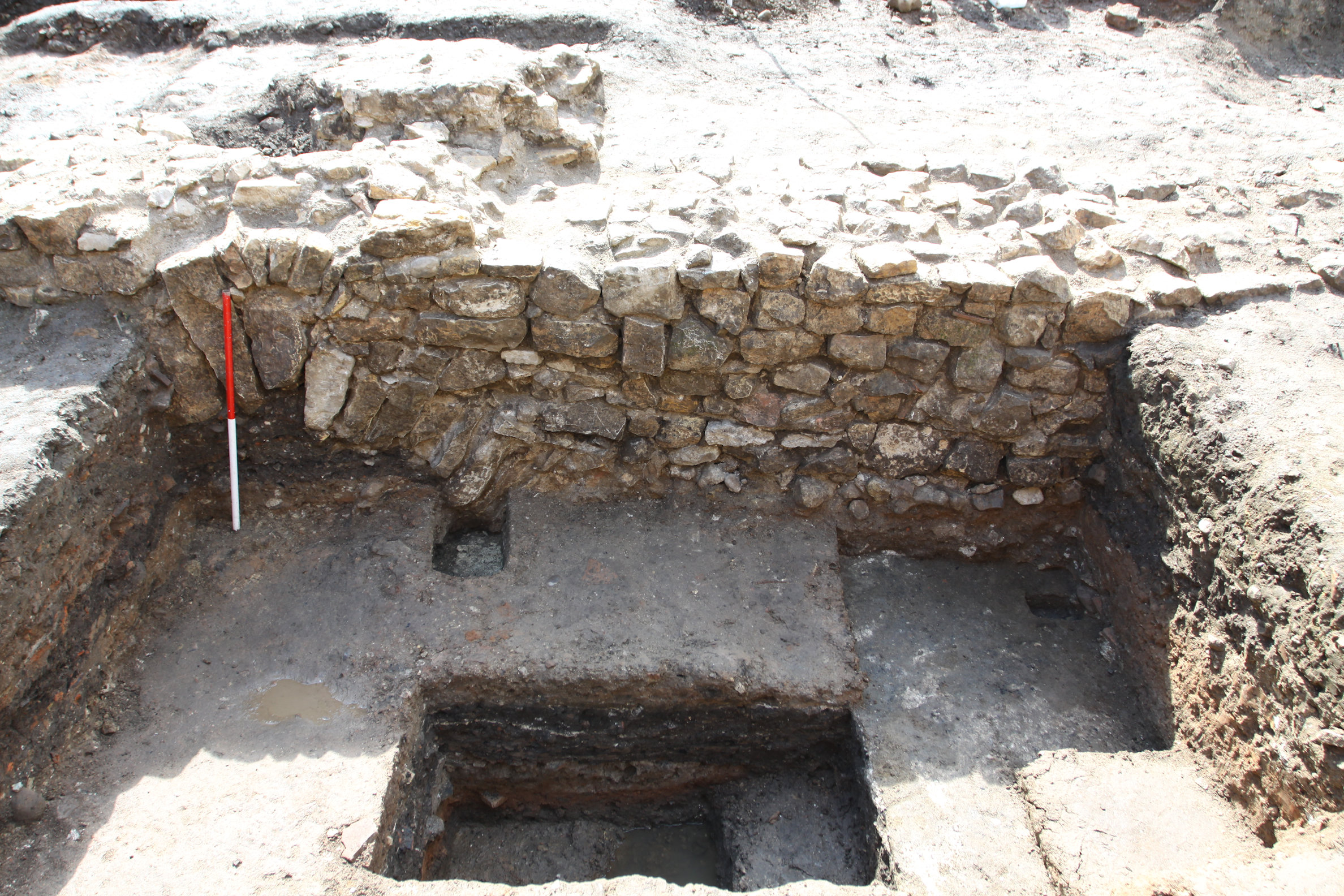
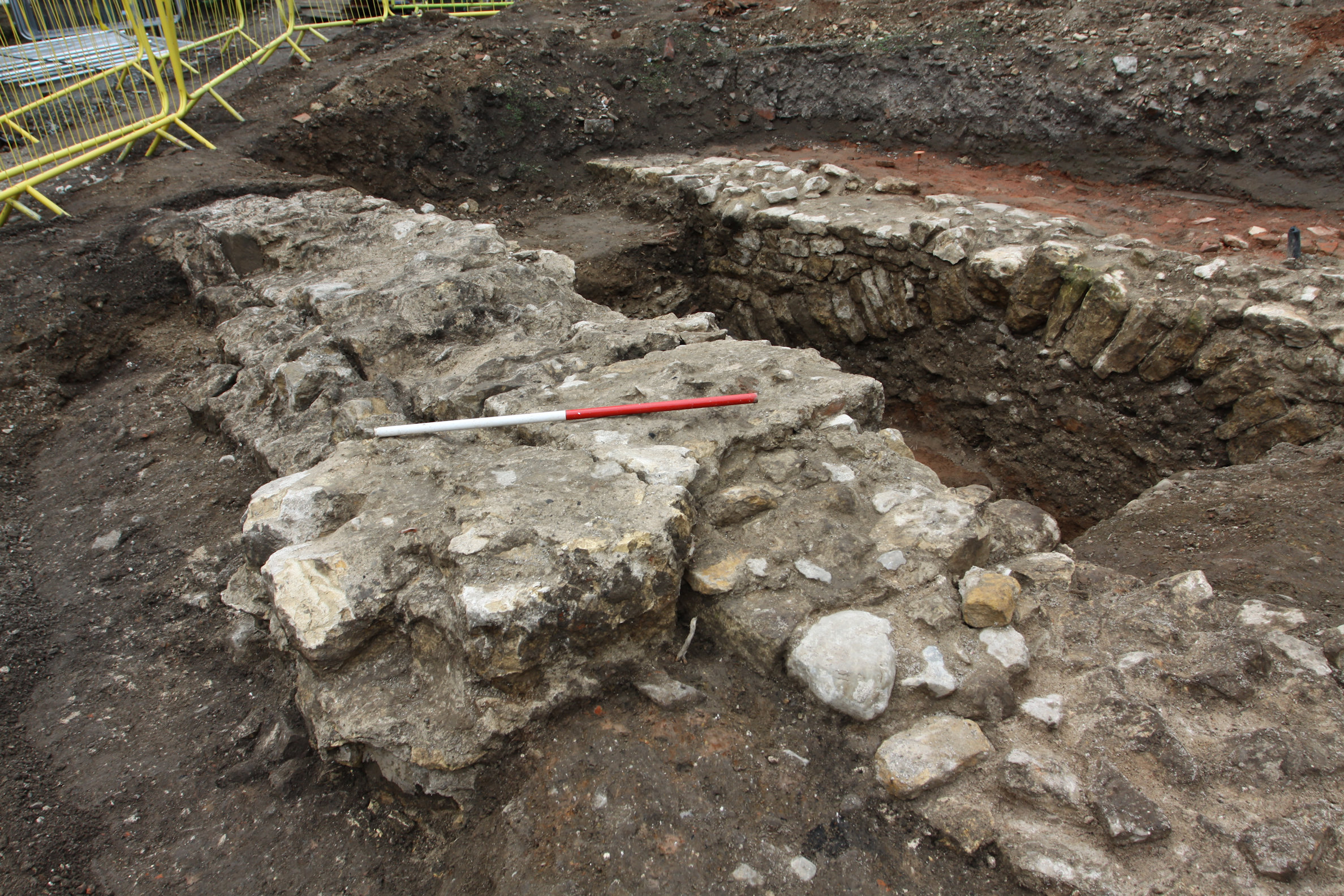
The wall ran close to the full length of Excavation Area 1 on a north-east/south-west alignment (Figure 48). It measured 13.02m long and up to 1.6m wide, although it averaged 1.2m in width. It only survived to foundation level, which at its north-eastern end was at 9.79m AOD, falling to around 9.25m to the south-west, an angle of 2.3°. The foundation (C3088, C8088; G158) comprised roughly dressed, randomly coursed Magnesian limestone blocks bonded with a soft, crumbly yellow white lime mortar; at the north-eastern end cobbles made up a greater proportion (Figure 49). Trench 3 provided the most extensive elevation view; here a relieving arch was present in the eastern corner of the trench and the base of the foundation was observed at around 8.3m AOD, making its height in this area approximately 1m (Figure 31 and Figure 50). No dateable artefacts were recovered from the fabric of the wall, however its position in the stratigraphic sequence indicates a date later than the mid-13th to mid-14th century features and deposits in P28 and P29.
On the south-eastern side of the wall and extending south-west of Trench 2 were mortar-rich stony deposits (C3047 and C3051; G158). These were perhaps either levelling deposits preparing the ground prior to wall construction or waste material generated during its construction.
Alterations were later made to the wall (see Phase 33), but no part of the structure appears to have survived above foundation level. Consequently, it is not entirely clear whether it was part of a building or a stand-alone feature such as a boundary wall. The date of features and deposits cut by the wall suggest a 14th century or later date, placing it within the life span of the Augustinian friary. Construction of the wall and the infilling of the linear feature in the north-east of the site could have related to the consolidation of zones of activity or reorganisation within the friary precinct.
By the 14th century the northern end of the site, south-west of the wall in P30, was being used as a graveyard. Five possible graves were found adjacent to the wall around Trench 2 and a further 13 burials were found across Excavation Area 2, NA WB 7 and NA WB 9.
Situated in an evenly spaced row, close to the north-eastern end of the G158 (P30) wall, were five possible graves (G160), all aligned north-west/south-east. They measured up to 2.36m long, 0.81m wide, and no more than 0.2m deep (Figure 47). No in situ human remains were found in any of the possible grave cuts, however, disarticulated human bone was recovered in sufficient quantity to suggest that each would have originally contained an inhumation burial.
More graves were identified in Excavation Area 2 and NA WB 7. Here, the graves appear to have been arranged in rows and included two instances where graves were found to intercut, indicating that the graveyard may have been in use for some time. In total, parts of ten inhumations were recovered from 14 possible graves (S1130 and S1144–56; G161). Where in situ remains were encountered these were invariably aligned north-west/south-east, and it was apparent that they had been laid out in an extended supine position. No complete individuals were recovered, either because of modern truncation or because part of some burials lay beyond the limit of excavation, although the general condition of the recovered bone was good.
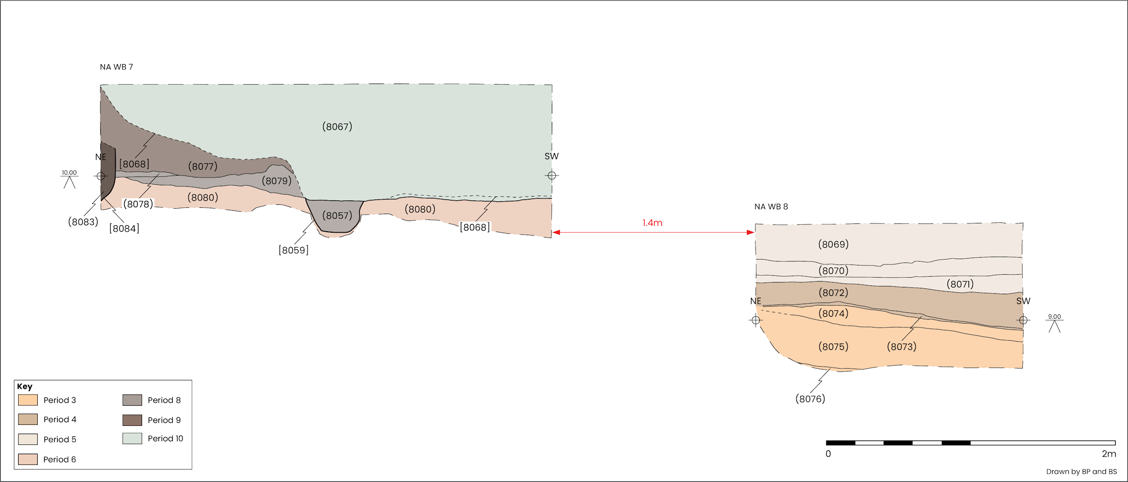
Two graves were encountered in NA WB 7 (Figure 15). In the north-eastern corner was grave cut C8084 (S1144); this was only seen retrospectively in section where its cut was observed to extend from 9.82–10.18m AOD. Part of an in situ inhumation (S1145) was found further to the south-west in grave cut C8059 extending from 9.61–9.84m AOD. It had been severely impacted by modern intrusion, but enough of the pelvis, femora and hands remained to identify an extended, supine burial with the hands placed across the pelvic area.
At the south-western end of the north-western row was grave S1146, containing SK8, an adult of unspecified sex. Later truncation had reduced the grave cut to between 0.2 and 0.45m long and 0.8m wide, which extended from 9.58–9.89m AOD. The extent of the later disturbance made it difficult to determine if any of the bone remained in situ, but some did appear to be articulated.
The next feature to the north-east was S1147, which was aligned north-west/south-east and measured 1.04m long, 0.68m wide and up to 0.24m deep, ranging between 9.9–10.14m AOD. No human remains were present in this feature, however its shape, size and position were similar to graves nearby.
The first definite burial on this row was SK3 in grave S1149. Here the lower legs of an adult of indeterminate sex in an extended and supine position were found in a grave cut that measured 0.58m wide and 0.35m deep, extending from 9.86–10.21m AOD. A modern drain had removed the south-eastern end of the grave and the feet along with it. Stepping in of the north-western edge of Excavation Area 2 at the level of this grave meant that only the south-eastern end of the grave was accessible; however, the distal ends of the femora could be seen in section. Late 12th to early 13th century pottery was recovered from the backfill.
Grave S1148 was 0.58m north-east of S1149 and measured 1.02m long, 0.75m wide and 0.51m deep, ranging from 9.81–10.32m AOD. The north-western end of the grave cut was within the limit of excavation in this area; however, the grave had been truncated from above and along its north-eastern side by a later grave (S1150) and to the south-east by a modern cut, both removing much of the burial. What remained intact indicated that the individual was a male, middle adult aged 35–44 (SK2), in an extended and supine position with the arms and hands extending either side of the pelvis. Radiocarbon dating of SK2 returned date ranges of 1415–1487 (68.3% probability), 1397–1530 (87.4% probability) and 1555–1623 (8% probability) (Savine 2024, 500, Appendix 5).
Cutting through S1148 was grave S1150. The cut for this grave extended north-west beyond the limit of excavation. The south-eastern end of the grave was investigated, revealing SK1 which comprised part of the pelvis and both legs and feet of a male, mature adult aged 45+, which was in an extended and supine position. The cut measured 1.5m long, 0.63m wide, and 0.46m deep and extended from 9.86–10.32m AOD. Radiocarbon dating of SK1 has returned date ranges of 1420–1499 (68.3% probability), 1400–1533 (85.1% probability) and 1553–1623 (10.4% probability) (Savine 2024, 500, Appendix 5).
The next grave in the alignment was S1156. Situated 0.93m north-east of S1150 this grave was only identified in section but was clearly cut into the backfill of linear feature S1131 (G156; P30). The cut was U-shaped in profile with a flat base, and measured 0.81m wide, 0.53m deep, extending from 9.81–10.34m AOD. Nothing was recovered from this grave, however ribs visible in section suggested that an in situ burial was originally present.
At the south-western end of the south-eastern row of graves was SK5 in grave S1151. Here a skull and mandible of an adult male was encountered in what may have been the north-western end of a grave, the cut of which ranged from 9.87–10.05m AOD. A single small sherd of almost certainly intrusive Pearl ware with a blue ribbed band was present along with a small quantity of Roman pottery.
The next grave (S1152) was 3.25m to the north-east. It had been truncated to the north-east by a later burial (S1153) and a modern drain to the north-west. It was only possible to investigate 0.4m of the grave's length, which here ranged from 9.93–10.22m AOD and contained SK6, part of the torso and right arm of an adult individual in a supine position. Roman and medieval pottery was present in the grave backfill.
Cutting into and removing part of the north-eastern side of grave S1152 was the north-western end of grave S1153. The cut measured 0.63m wide and 0.44m deep, extending from 9.78–10.22m AOD. Only a 0.35m length of this grave was excavated, but it was found to contain the skull of a male aged 35–44 (SK7) and a quantity of disarticulated human bone.
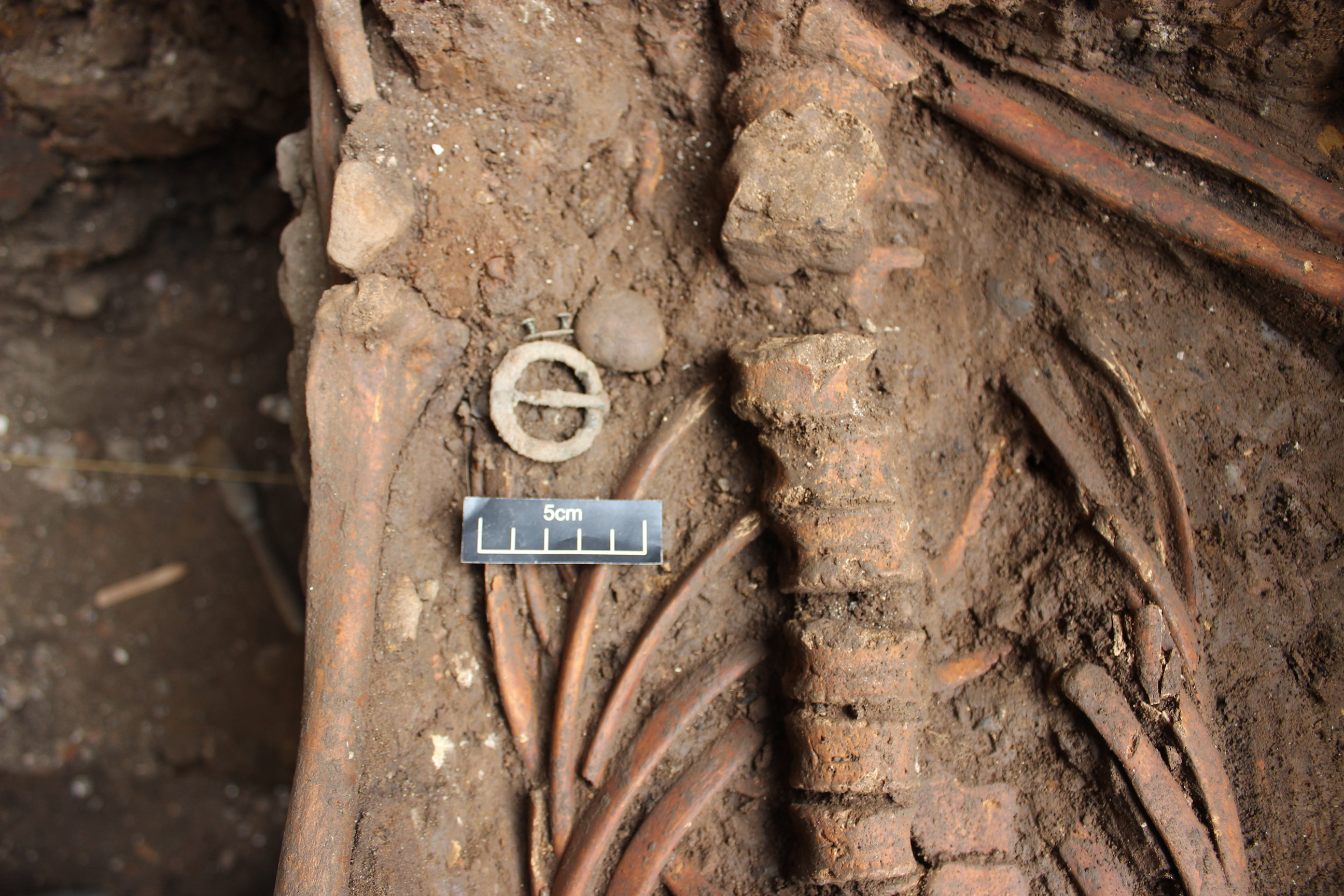
Grave S1154 was 0.37m to the north-east of S1153. The grave cut ranged from 9.94–10.38m AOD, and was truncated to the north-west and north-east, leaving a width of 0.48m. Only 0.37m of the length could be excavated, the rest extending south-east beyond the limit of excavation. The grave contained SK4, an adolescent individual aged 12–17 years, which had been laid in a supine position with the right arm flexed at the elbow from where the radius and ulna extended towards the pelvis, while what was exposed of the left arm extended straight along the left side of the body. A copper alloy annular brooch (SF196) and a copper alloy belt fitting (SF197) were found positioned just below the ribs on the left side of the torso (Figure 51) and late 14th to early 15th century pottery was recovered from the backfill.
Located furthest to the north-east was SK8 in grave S1155. It had been truncated to the north-west, north-east and south-east, and appeared to extend below a concrete pad to the south-west. The base of the grave was at 9.85m AOD. Only the skull, mandible, right scapula and part of the right humerus remained, together suggesting a supine burial, in this case of a probable female aged 18–25 years. A late 4th century CE copper alloy coin (SF216) was found in the grave backfill, alongside fragments of 14th century pottery.
Disarticulated human bone was also found during excavation around a pile cap in a NA WB 9. Here the south-western side of a cut feature measuring 1.07 x 0.55m and 0.26m deep (S1130; G161) was identified in section and fragments of vertebrae, rib and humerus were recovered from the vicinity. The position, alignment and content of this feature suggests that it was a grave.
With the exception of a possible charnel pit in NA WB 10 (S1138; G159; P34), all deliberately deposited human remains were inhumation burials located south-east of the wall in P30, and with the exception of two graves were south-west of possible linear feature S1131 (P30). No burials were found south-east of wall S1085 (G137; P21). The general impression is of a well-organised and maintained graveyard, although there were two instances of intercutting burials, perhaps indicating grave markers were not necessarily universal or that the graveyard was in use long enough for burial locations to become lost or unclear. The burials and associated features were in perhaps as many as four rows, each arranged along a north-east/south-west axis, an alignment shared by medieval stone-built buildings to the west and the slight fall in ground level down towards the river.
A gentle downward slope in the topography from north-east to south-west may also be reflected by the depths to which graves were dug. The bases of possible graves in G160 adjacent to the P30 wall ranged in height from 9.4–9.6m AOD, while further to the east the height range of graves in G161 was between 9.58m and 9.94m AOD. The two deepest graves in G161 were S1145 and S1146, both located furthest to the south and the west in that area, while the only two above 9.9m AOD (S1152 and S1154) were among those towards the north-eastern end of the site. Seven of the graves where human remains were present had a maximum depth range of between 9.81m and 9.9m AOD (S1144, S1148–51 and S1155–56).
Determining a date for the use of the graveyard generally relies on the dating of the deposits cut by the graves. A few largely intact archaeological horizons were present above the graves, and while artefacts present in grave backfills may be informative there is a significant likelihood of residuality. In the case of the possible graves in Excavation Area 1, three cut into, or were very close to, 14th century pits in P29, while the two potential graves south-west of Trench 2 cut into S1123 deposits in G154 that were related to the construction of the adjacent wall and postdate the P29 pits. The fills of these features had clearly been heavily disturbed in the post-medieval period (see Phase 36) which may account for the tendency towards 15th and 16th century pottery and the presence of a Nuremburg Jetton issued between 1500–25 (see section 6.12; Table 33). The graves in Excavation Area 2 cut into Roman deposits, 12th–13th century levelling deposits (P21), or the 14th century linear feature S1131 (P30), while no burials were found at the south-eastern end of the area beyond the P21 wall S1085 (G137) wall, which appears to have been standing until at least the 13th century. As might be expected, residual Roman artefacts were regularly present in G161 grave backfills. Medieval artefacts were only recovered from four graves, including pottery ranging in date from the late 12th to the early 15th century, and 13th–16th century CBM. The radiocarbon dates for SK1 and SK2 from intercutting graves S1148 and S1150 were virtually identical, giving a 15th or early 16th century date at around 85% probability, which would place them comfortably within the anticipated timeframe suggested by dating of adjacent deposits, features and structures.
The graveyard was located in what appears to have been the south-eastern periphery of the Augustinian friary, adjacent to land occupied by the Guildhall since at least the 15th century. The available dating evidence broadly establishes a 13th–16th century date for use of the graveyard, complementing the life span of the friary. By the 14th century its north-western side was delineated by the large limestone wall (G158; P30), while to the south-east a smaller structure (G137; P21) dating to the late 12th to early 13th century may still have been standing. In this circumstance any growth to the graveyard might prompt intercutting of burials, as seen between S1148/S1150 and S1152/S1153, or expansion to the north-east and south-west, perhaps resulting in the infilling of the possible linear feature (P30) in the 14th century. Notably, graves S1154 and S1155 were both close to that feature and were 14th century or later in date.
From around the 14th century land to the north-west of the wall in P30 was occupied by a substantial stone building.
Extending 2.08m from the north-western side of Excavation Area 1 and up to within 2.39m of the P30 wall foundation was part of a large stone building. Demolition of the building had left only the south-eastern wall foundation and elements of an internal sub-floor structure intact. Parts of this building were encountered in NA WB 1, NA WB 2 and Trench 4 in Excavation Area 1 (Figure 47).
The wall foundation (G164) was aligned north-east/south-west (parallel to wall G158; P30), measured 0.86–1.06m wide and was traced from the south-western end of Excavation Area 1 for over a distance of 11.66m north-east to the northern corner of Trench 3 (Figure 48). At this point there appeared to be a return to the north-west where CBM rubble extending along the north-western side of the wall foundation petered out (see S1189; G169; P36). However, that part of the foundation lay just outside of Trench 3 and was not investigated in any detail; consequently, a continuation to the north-east is possible. The wall foundation comprised a rubble core faced along both sides with roughly dressed Magnesian limestone blocks bonded with a soft, creamy white lime mortar (G164). Trench 4 provided a 3.72m long profile of the south-eastern face of the foundation, there exposing seven courses of stonework rising over the south-western end of a relieving arch which extended down approximately 1.6m from 9.17m AOD (Figure 52). A selection of Roman vessel types, 12th–13th century gritted oxidised wares and 13th–16th century CBM were recovered from the construction cut backfills where they passed through Trenches 3 and 4 but given the depth of the foundation construction cut this probably reflects the date of the underlying features and deposits rather than when the building was constructed.
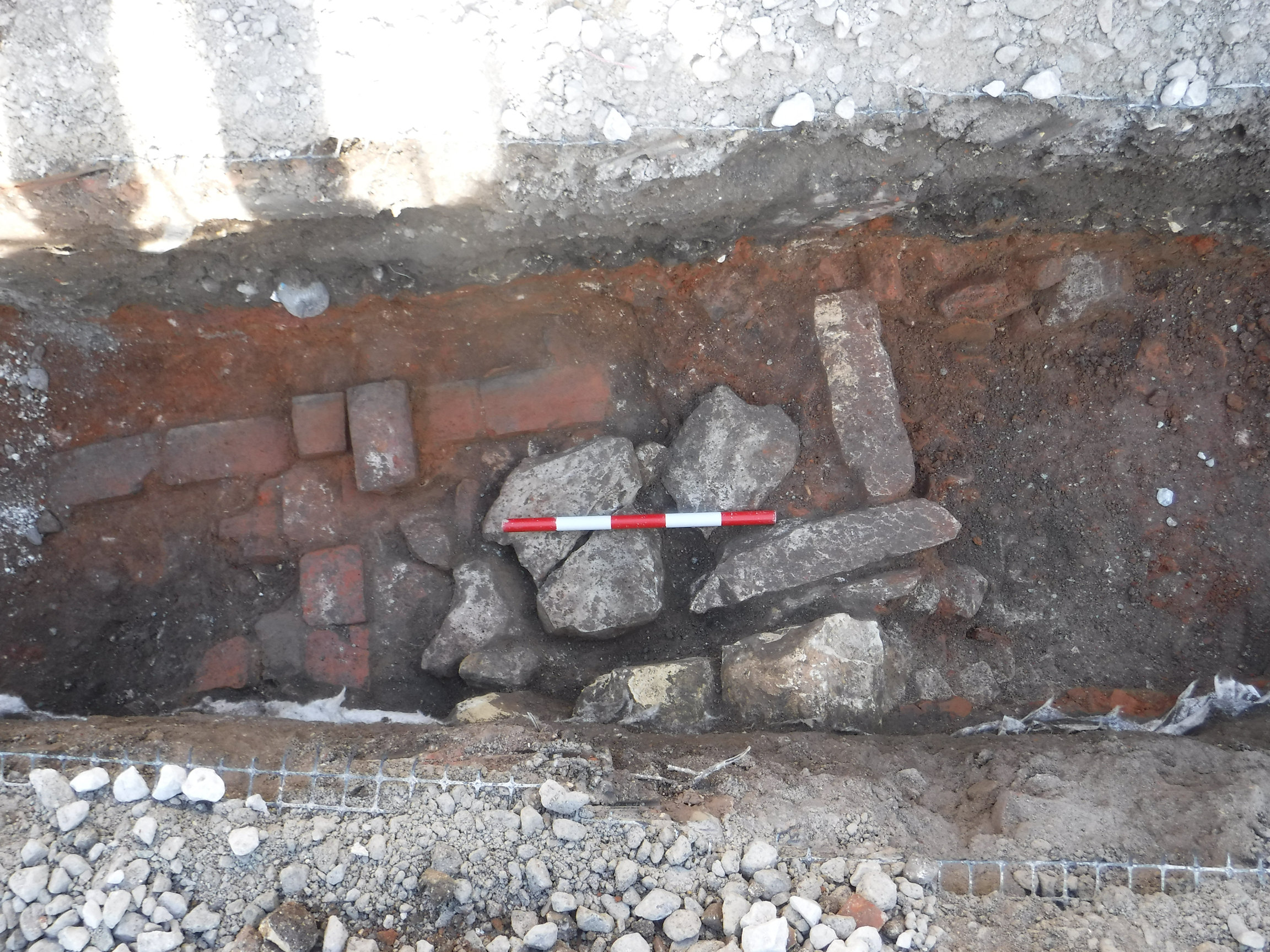
On the north-western side of the wall, in NA WB 1 and NA WB 2, foundation structures were present, which may have supported a floor inside the building. The earliest deposits were observed at the base of the north-facing section of NA WB 1. Here, a flat levelling deposit covered by a thin layer of trampled material dating to late 14th to early 15th century (C8024) extended to 8.98m AOD. Above this, and extending north-east in a 1.59m long, 0.36m wide strip were edge-set tiles (C8005; S1165) bedded into soft sand. The tiles may have formed the footing for wall C8052, part of which was observed in the northern section of NA WB 1. More edge-set tiles (S1166) were found adjacent to the G164 limestone wall foundation and also formed the footing of a foundation. This foundation, S1167, was aligned north-west/south-east foundation, which was formed of reused limestone blocks and measured 2.62m long and up to 0.51m wide. At its north-western end it continued into the trench section on a line where it almost certainly would have met the S1165 wall footing. Above the point in the section beyond which S1165 and S1167 extended was a brick wall six courses in height, made up of orangey red bricks bonded with a soft orange-brown sandy mortar (S1168).
Abutting the north-eastern face of foundation S1167 were two low brick walls (S1169–70) supported on a flat, hard, mid-orange brown surface, possibly made from CBM (S1162). This was seen at around 8.8m AOD in a 0.45 x 0.3m sondage positioned 0.72m north-west of the G164 wall foundation. The low brick walls were aligned north-east/south-west and were spaced 0.53m apart with S1169 abutting the north-western side of wall foundation G164. Both walls were constructed from 14th–16th century bricks identical to those in S1168 and were neatly faced on their external edges. Both also had a brick rubble core. Wall S1170 was six courses high, and the top courses of both walls were at approximately 9.15m AOD.
A brick wall (S1171) identical in construction to S1169, was similarly found to abut the north-western side of wall foundation G164, 3.77m to the north-east in NA WB 2. At the north-eastern end of S1171 and running perpendicular to it was a limestone-built wall or footing (C8028; S1172). Like the limestone wall S1167 it was aligned north-west/south-east and abutted wall foundation G164 (Figure 53).
The relationship between the wall foundations in G158 (P30) and G164 was not entirely clear. It is possible that wall foundation G158 supported a freestanding wall sited along a boundary, on one side of which was the graveyard and on the other a building, of which G164 formed the south-eastern side. Extending to the north-west the interior of that building had a suspended floor supported on low brick walls (S1169–70) dating to the 14th to 15th century. The wall foundations share some characteristics, for example the construction techniques and materials employed appear very similar, and both were probably constructed in the 14th century. Conceivably they were part of the same structure, the 2.5m spacing between these parallel walls hinting at this being an aisle on the south-eastern side of a larger building that extended north-east/south-west through the friary precinct.
Alterations to wall foundation G158 (Phase 30) included the addition of buttresses (S1175, S1176, S1177) and an extension, reinforcement or rebuilding to the south-west (S1173). The mortar used to bond the stonework in these additions was identical but not the same as that used in the original construction. It is unclear when the remedial work took place, but it does appear that the north-eastern buttress disrupted two of the medieval burials in Trench 2, one of which contained 15th to 16th century pottery.
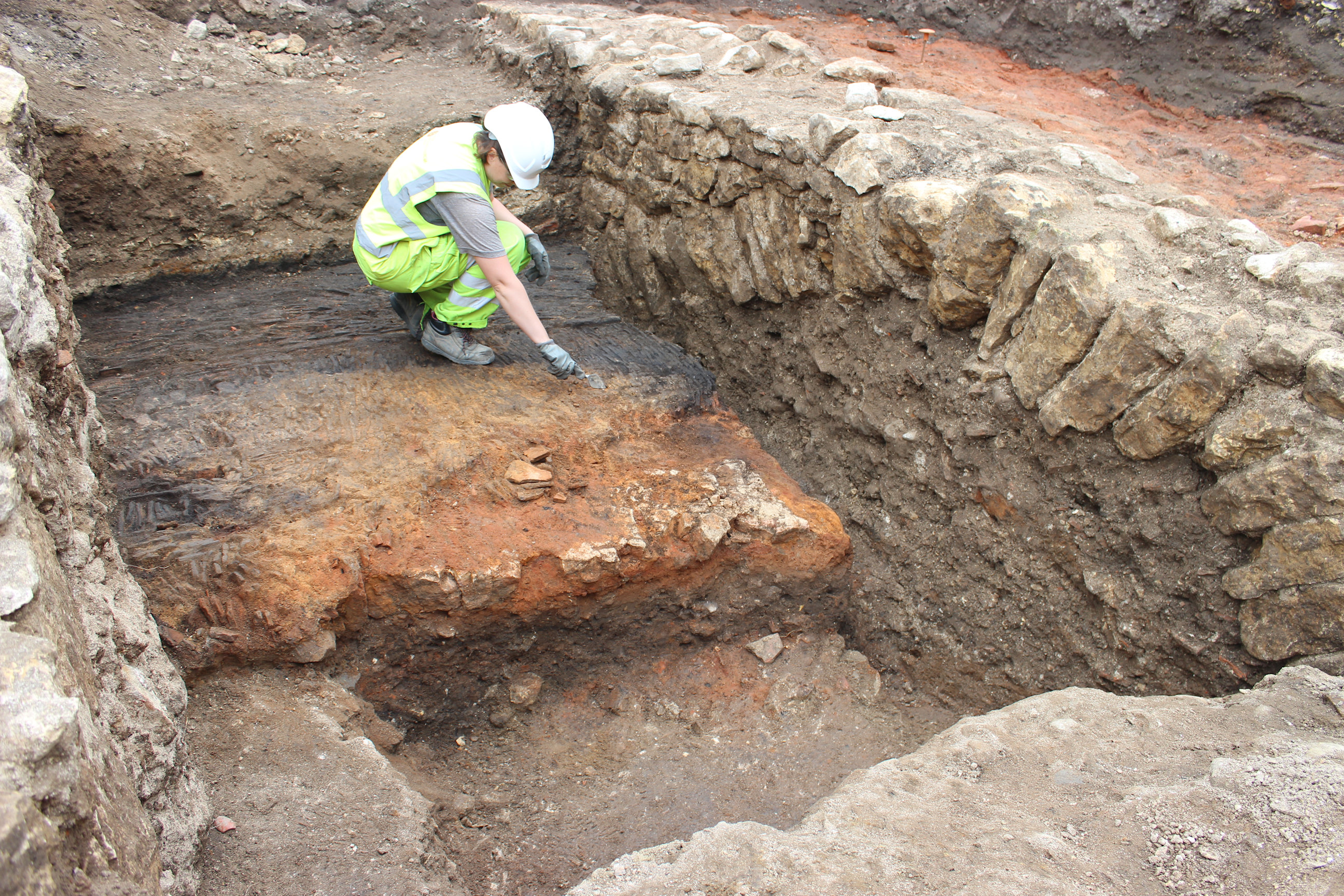
From a break visible across the upper surface and down the north-western face of wall foundation G158 (P30) the line of the wall continued to the south-west as S1173 (Figure 47). Measuring 1.01–1.2m wide, this section of wall extended south-west over a distance of 5.29m, taking it to the end of Excavation Area 1 and continuing into NA WB 4 and NA WB 5. This section of foundation was constructed using roughly dressed Magnesian limestone blocks bonded with very hard, coarse, light grey white lime mortar. Two Magnesian limestone blocks (AFs 10–11), dating to 1066–1540, were recovered from the top course, C8092. Part of a relieving arch was visible arcing down to the south-west in NA WB 5 (Figure 54). The course of stonework above the top of the arch was secured with a copious amount of mortar, which was also visible up the north-western face of the foundation where it was exposed in Trench 4 (Figure 55).
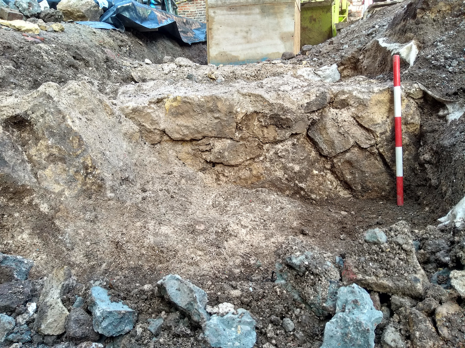
Randomly coursed limestone rubble S1174 had been fixed up against the south-eastern face of S1173 with large quantities of hard, coarse, light grey white mortar. S1174 extended the full length of S1173 and up to 0.52m to the south-east of it. At the north-eastern end of S1174 and abutting wall foundation G158 was one of three buttresses that had been added to the south-eastern side of that wall. Buttress S1175 extended 1.19m along the wall and projected 0.8m from it. The next buttress (S1177) was 3.79m to the north-east of S1175 and measured 1.22m north-east/south-west and 1.3m north-west/south-east. The third buttress (S1176) was situated a further 4.05m along the wall foundation. Its position inside Trench 2 allowed for closer inspection. The construction cut measured 1.32 x 1.36m and extended from 9.04–9.7m AOD. All of the buttresses had been coated in large quantities of the same hard, coarse, light grey-white mortar used in the other G166 structural elements, to the point at which, even where the three faces of S1176 were exposed, any coursing or structure to the stonework used was not visible (Figure 48).
The slight gap between the G158 (P30) part of the foundation and the foundation in this phase may simply be evidence of extension of the structure to the south-west. Alternatively, and perhaps more likely given the additional thickening of the wall to the south-east and the placement of buttresses (particularly one directly at the point of weakness in the earlier wall), this part of the structure had perhaps begun to fail, therefore requiring significant repairs and reinforcement. It has not been possible to precisely determine when this work took place as the next clear phase of activity was the demolition of the buildings and the clearance of the site following surrender of the friary in 1538 during the Dissolution (Raine 1955, 133).
Determining dates of deposits and features observed in the various watching brief trenches was hampered by infrequent recovery of artefacts during those works. Drawing parallels with securely dated deposits and features of a similar character, and similar physical and stratigraphic position is possible however, and this allows for a broad comparison.
In NA WB 7 and 9 (Figure 47), deposits typically consisting of soft, mid-pink brown silty sand, C8079 and C8087, were observed extending to around 10.08m AOD. The north-west facing section of NA WB 7 shows the deposits there were earlier than the possible graves in G161 (Figure 15), although those deposits lacked the consolidated character of the 12th–13th century deposits in P21, cut by graves in Excavation Area 2.
Across NA WB 3, 9, and 10 was evidence of soil accumulation, usually mid-green or mid-grey brown coarse sandy silts (C8063–64, C8065–66 and C8047; G155). The composition and character of these deposits was comparable to mid-13th to mid-14th century deposits seen further to the south-west in Excavation Area 1 (G151 and G194; P28). In addition, C8047 predated a probable wall and cobble surface (see G157 and G163; P35 below) which may relate to the building in P32.
Cutting into the G155 deposits in NA WB 10 was charnel pit C8056. This was the only burial feature found to the north-west of the G158 (P30) wall foundation.
Cobbles bedded into dark orange brown clay (C8044–45; S1132) were exposed at the base and in the north-west facing section of NA WB 3 at around 9.45m AOD (Figure 47). This probable surface was situated north and east of a possible wall foundation comprising lime mortar bonded limestone (S1136), aligned north-east/south-west and measuring 1.6m long and 1m wide. S1136 followed the same line as wall foundation G164 (P32), the established extent of which was 6.08m to the south-west. If S1136 was part of the G164 wall foundation it would have measured at least 17.41m long.
Extending into NA WB 11 on a north-east/south-west alignment and measuring 1.29 x 0.99m was the south-western end of a mortar-bonded limestone footing (C19036; G195). This stone footing was located 1.56m north-east of wall foundation G158 (P30) and was offset slightly to the east of it, 2.52m directly north-east of buttress S1176 (P32). The form of construction, in particular the mortar used, was more like that used in the P30 foundation build than in later alterations (P33). In addition, wall foundation G158 clearly did not extend into NA WB 11, as a cobble surface was present abutting the north-eastern side of the footing (Figure 56). The surface was composed of small cobbles, pebbles and gravel bedded into a gritty clay present at 9.5m AOD (C19037–38; G195).
The cobble surfaces in NA WB 3 and 11 were both at approximately 9.5m AOD and, while separated by 4.2m east-west their form, character and that of adjacent structural elements suggests a link between them and the P32 friary structures in use from around the 14th century onwards.
Internet Archaeology is an open access journal based in the Department of Archaeology, University of York. Except where otherwise noted, content from this work may be used under the terms of the Creative Commons Attribution 3.0 (CC BY) Unported licence, which permits unrestricted use, distribution, and reproduction in any medium, provided that attribution to the author(s), the title of the work, the Internet Archaeology journal and the relevant URL/DOI are given.
Terms and Conditions | Legal Statements | Privacy Policy | Cookies Policy | Citing Internet Archaeology
Internet Archaeology content is preserved for the long term with the Archaeology Data Service (ROR). Help sustain and support open access publication by donating to our Open Access Archaeology Fund.
 Home
Home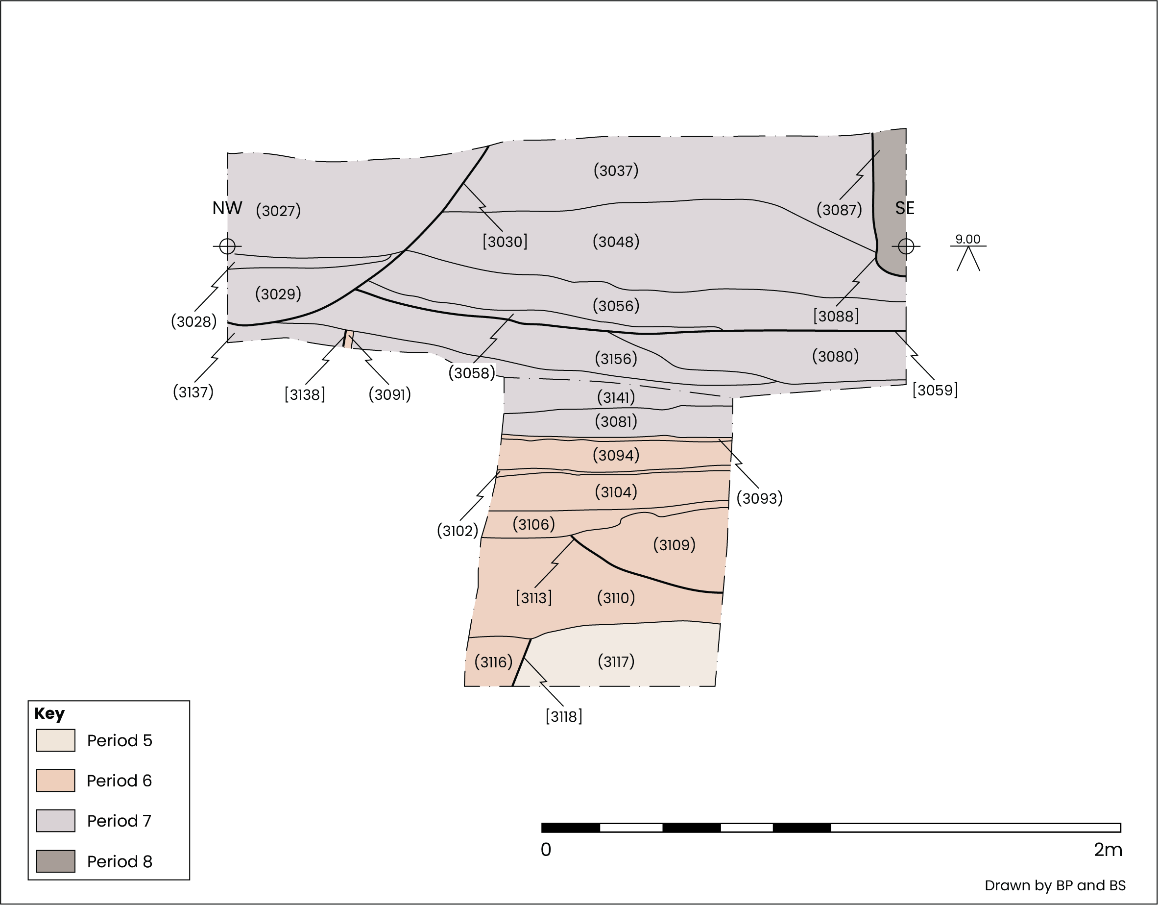