Cite this as: Savine, B. et al. 2026 Archaeological Excavations at the North Annexe, York Guildhall, Internet Archaeology 71. https://doi.org/10.11141/ia.71.10
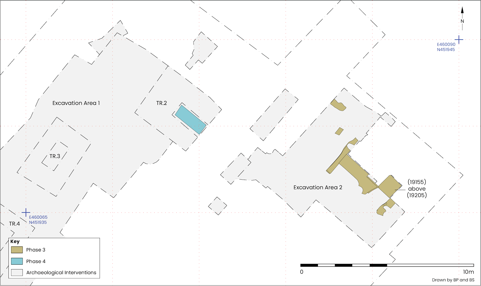
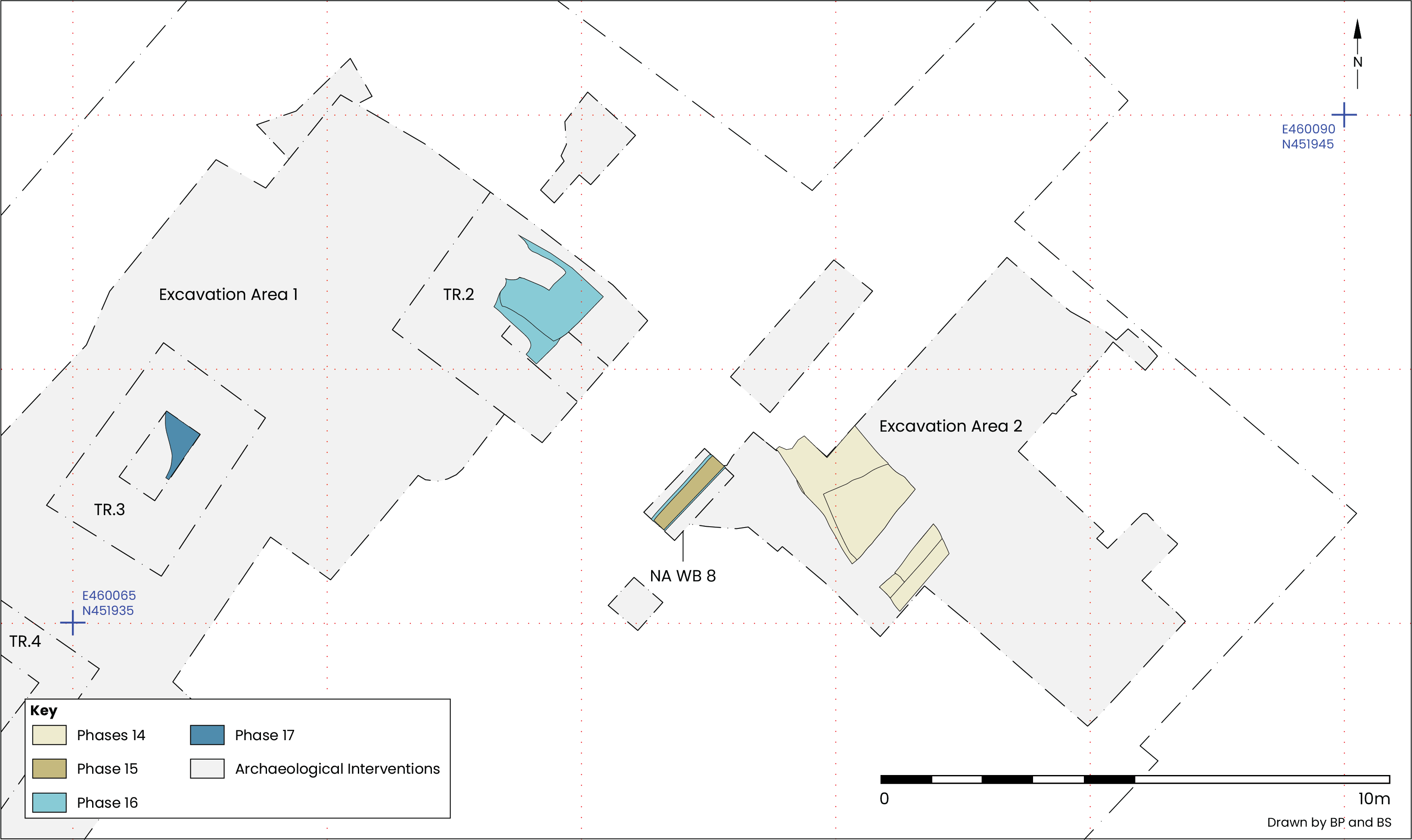
Phases 1-2| Phases 3-5 | Phases 6-9 | Phases 10-13 | Phase 14 | Phases 15-17
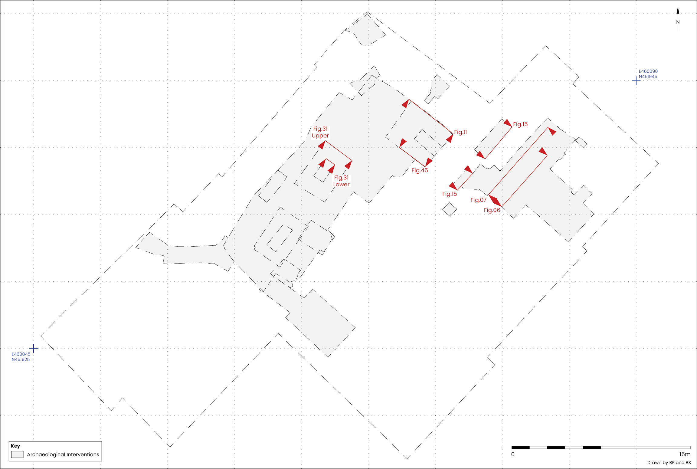
No evidence was found for activity predating the Roman period at the site. Glacial deposits were encountered in all six boreholes drilled on the site by YA in 2019 (Jackson-Slater and Krawiec 2020, 8) and at the north-eastern end of the site in Excavation Area 2, where some indication for the reworking of the top of the till was identified (Figure 5, Figure 6, Figure 7).
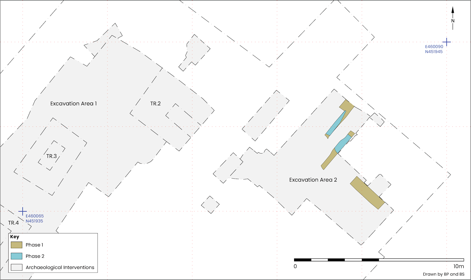
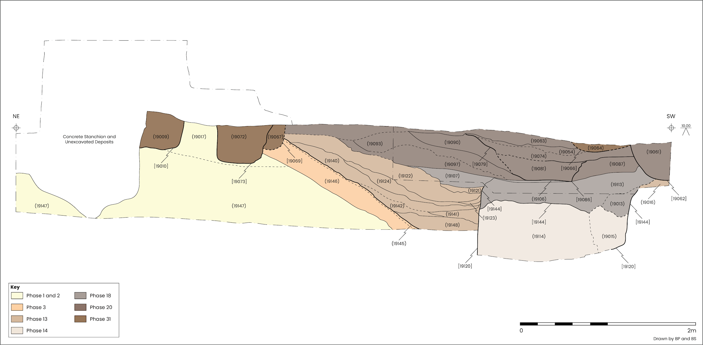
A firm, light red brown clay with light grey horizontal streaks containing small stones (C19117, C19147 and C19157), was encountered in the north-eastern part of Excavation Area 2. The top of this material was at 9.96m AOD and dropped gradually to 9.67m AOD at the south-west (Figure 5, Figure 6 and Figure 7).
Glacial till was also encountered during the course of a borehole survey and piling watching brief carried out in August 2019 (Jackson-Slater and Krawiec 2020, 5). Here naturally occurring deposits were found to slope down towards the River Ouse, from a maximum height of 7.27m AOD at the north-east, to 2.2m AOD at the south-west end of the site (Figure 2).
Above the glacial till was a roughly 0.4m thick deposit of firm, mid-orange brown clay (C19017–18) containing rounded stones of various sizes (Figure 5). At their highest point these deposits extended to 10.26m AOD, 0.3m higher than the upper extent of those in P1, but they did not have the same stratified composition as the glacial till. It is not clear whether the disturbed appearance of this deposit was the result of natural processes or anthropogenic re-working, as no finds were recovered. If this material was redeposited as a result of human intervention there is the possibility of that activity corresponding to the landscaping or terracing undertaken in the late 1st or 2nd century CE assigned to Period 2, below.
Directly above the possible reworked glacial deposits in Excavation Area 2 was evidence for ground clearance and preparation. Here the cutting back of natural deposits on a north-west/south-east axis, broadly parallel to the river, created a slope which was then covered with gravel (Figure 6 and Figure 7). The earliest deposits found downslope and south-west of the gravel bank were fairly flat, as were those at the base of Trench 2 in Excavation Area 1, hinting at a flat area running along the foot of the bank.
Where natural deposits in P1 and P2 were observed the ground surface had been cut back along the south-western face to an angle of 30.5° (Figure 6). This modification appears to have been carried out in preparation for the laying of a compacted gravel surface across the slope (C19116, C19118, C19146 and C19205). It may be that C19017–18 were redeposited as part of a landscaping process, perhaps involving terracing in the space between the front of the fortress and the north-eastern bank of the River Ouse (Figure 8).
In Excavation Area 2 the gravel bank was exposed in section, providing a 1.76m long profile of gravel packed directly onto exposed P1 and P2 clays where they sloped down to the south-west. From a maximum height of 10.03m AOD at its north-eastern end, the gravel was consistently around 0.24m thick, to the point where the limit of excavation was reached at a height of 9.04m AOD (Figure 9).
Some flattening off at the top of the bank was observed, although at varying heights across Excavation Area 2. To the north-west C19118 and C19146 levelled off at 10.32m and 10.25m AOD respectively. Further south-east C19205 covered a flat area approximately 1m², reaching around 10.1m AOD (Figure 10), and it is perhaps the case that the lower height observed there was influenced by a later feature cutting into the gravel bank just below.
A single small rim sherd of Roman grey burnished ware was recovered from C19116 near the north-western limit of where the bank was exposed. This single pottery sherd could have been intrusive, given the large, modern drainage trench that bisected this part of the site. Present above the gravel in this area was a 20–30mm thick sandy silt deposit (C19145), either the result of foot traffic, if the gravel was a steep lane leading down to the river, perhaps disturbing the gravel surface and depositing debris from muddy footwear, or the beginning of soil formation over the top of it (Figure 6).
Close to the eastern corner of Excavation Area 2 a patch of firm, stony, dark orange-brown silty clay (C19155), was present above the gravel bank. This deposit followed the slope of the bank and represented a repair or a resurfacing event. Two small pottery sherds were present, with a late 2nd to early 3rd century CE date range, although there is a high probability that they are intrusive as a large quantity (30 sherds) of pottery of the same date range was recovered from a channel (S1032) cutting into C19155. Later soil accumulation above the gravel surface, only 2.3m to the north-west of the location of C19155, appears to have occurred at some point after the late 1st to early 3rd century CE (see P13).
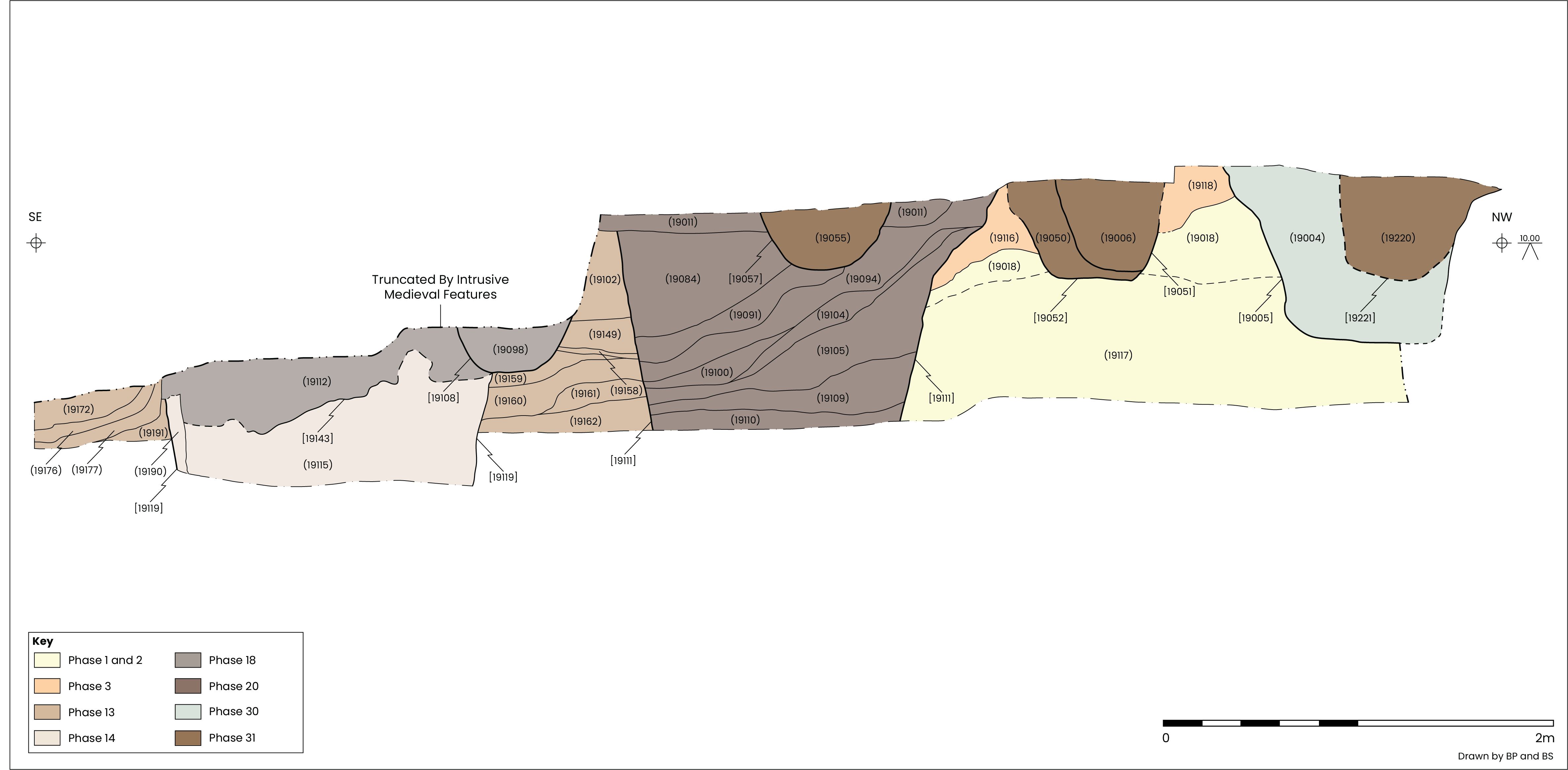
The earliest feature exposed in Excavation Area 1 was at the base of Trench 2. Here cobbles within a matrix of mid-green brown silty clay (C3125), most likely a surface, sloped gently down to the north-west from 8.14m to 8.02m AOD (Figure 8 and Figure 11). Unfortunately, it was not possible to explore C3125 beyond exposing its upper surface, and no datable material was recovered from it.
If, as seems probable, the landscaped bank extended across to the north-western part of the site, the surface appears to have been laid onto a flat area, possibly a man-made platform or terrace at the foot of the bank. The stony character of the deposit suggests that it was either a surface within a utilitarian building or part of an exterior space. Despite similarities in the character of deposits at the top and foot of the gravel bank, drawing a definitive temporal link between them is hampered by an absence of dating evidence for C3125. To an extent this is exacerbated by its lack of a direct stratigraphic relationship with the gravel bank, an understanding of their relationship being reliant on the height range of the gravel bank and the position of C3125 relative to it.
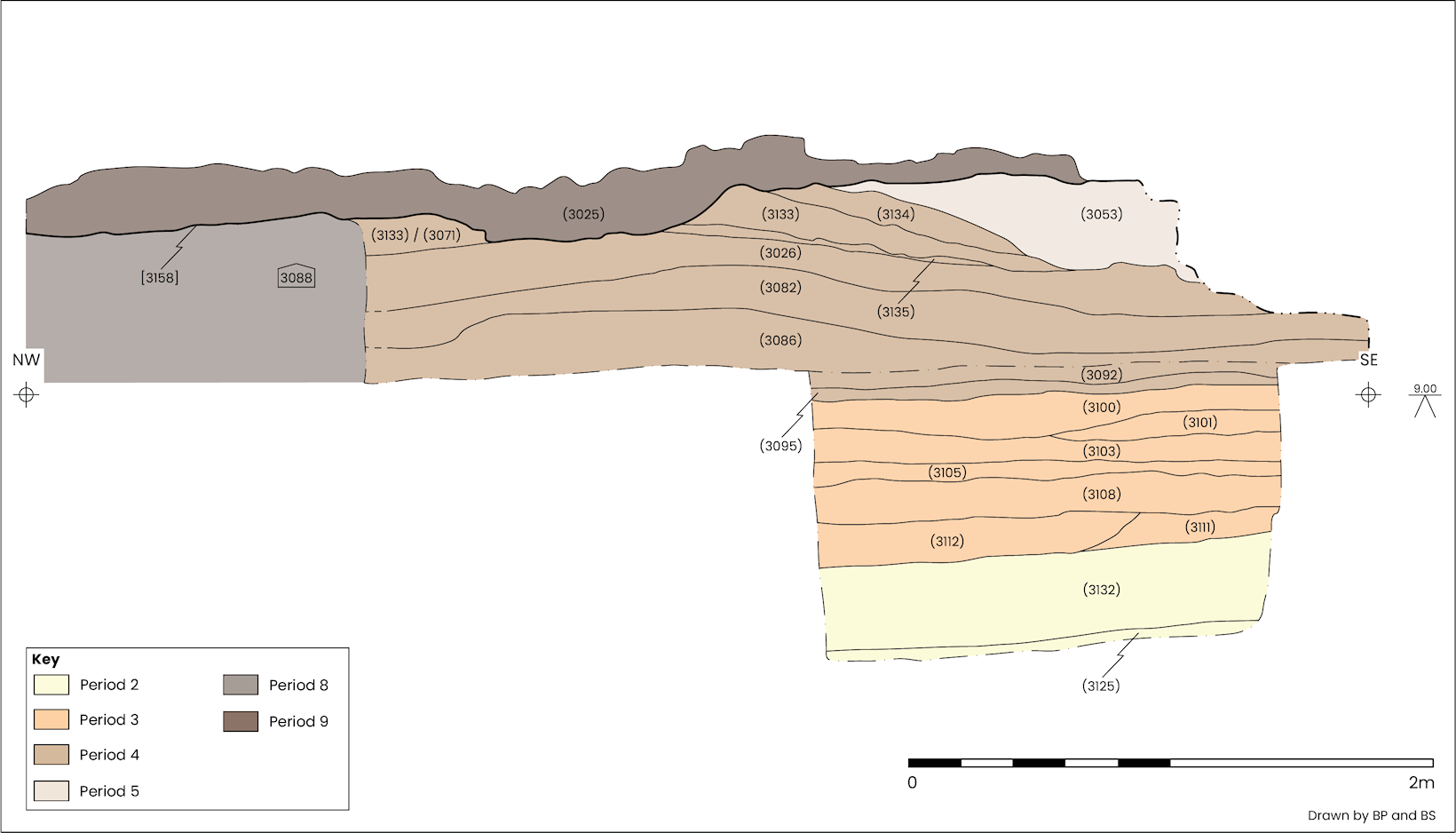
Above the P4 surface in Trench 2, a 0.3m thick layer of organic grey silty clay (C3132; G104) had been deposited (Figure 12). This levelling deposit followed the same gentle slope as C3125 and extended to a maximum height of 8.48m AOD (Figure 11). Within it were fragments of charcoal and other organic material. A copper alloy toilet implement (SF43) was recovered along with several small to medium sized fragments of Ebor ware dating to the late 1st to early 2nd century CE.
Similar flat dark silty levelling deposits (C19200 and C19201; G105), were found at the south-western end of Excavation Area 2, a short distance downslope from the gravel bank in P3 (Figure 12). Both had organic contents, including charcoal and wood fragments. The lowest of these (C19201) was present from 8.56m AOD and produced pottery dating to the late 1st to early 2nd century CE. Overlying this was C19200, a thin deposit of similar date, in this case late 1st–2nd century CE, which extended to 8.62m AOD.

Although separated by a distance of 5m, deposits in G104 and G105 shared some characteristics. All were comparable in composition and occupied a level area, possibly a terrace extending north-west to south-east, downslope of a steep gravel-faced rise in ground level north-east of the River Ouse. The thickness of build-up over the surface in P4 shows a change in the use of that space; the previous activities carried out in that area were superseded by dumping of what appears to be waste materials and/or the establishment of soil formation.
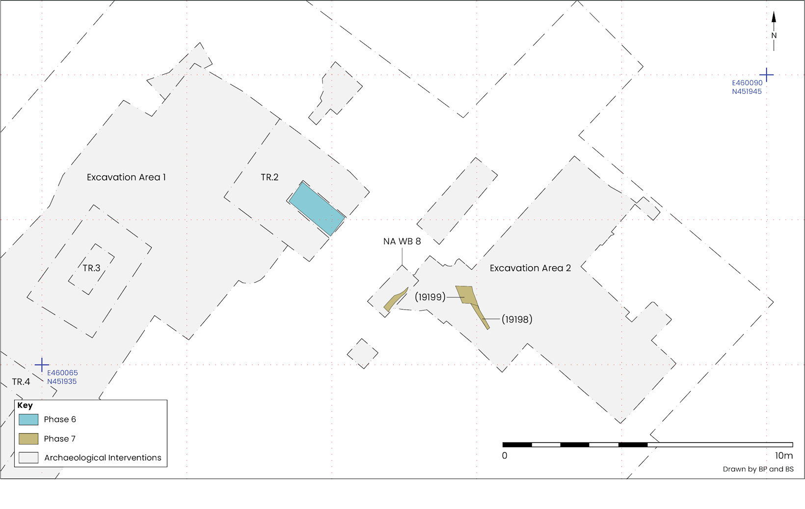
Use of the flat area at the foot of the bank at the north-eastern end of the site continued to develop during the 2nd century CE. There was evidence for a building in Trench 2 and the dumping of waste at the south-western end of Excavation Area 2 and NA WB 8. Both were later covered by material derived from demolished buildings.
The next deposits in Trench 2 were drier and sandier than those preceding them (Figure 13). Two firm mottled silty sand levelling deposits, containing large quantities of CBM (ceramic building material) and 2nd century CE pottery (C3111/C3112), raised the ground level slightly to 8.56m AOD, providing a 0.1–0.16m thick barrier against the damp material below (Figure 11). These dry deposits acted as a sub-base, preparing the ground for a probable floor above (Figure 14).
The floor (C3108) covered the full extent of the excavation at this level, an area approximately 2 x 0.8m, and was made up of light-yellow brown silty sand up to 0.16m thick, reaching 8.71m AOD.
Overlying the possible floor was C3105, an occupation deposit dating to the 2nd century CE. It comprised firm, mid-grey green silty sand that was 30–90mm thick. Relatively thin and compact, this deposit is likely to have formed during the use of the floor ( Figure 11).
The probable floor in this phase is very different to the surface in P4 and is more likely to have been internal. However, no other structural elements were apparent in Trench 2 at this depth.
Above the G105 deposits ( P5) at the south-western end of Excavation Area 2 two mid-brown silty and clayey deposits were present. In contrast to the flat deposits below, both C19198 and C19199 tipped down to the south-west and were uneven on top. A small quantity of late 1st to 2nd century CE pottery was recovered from C19199.
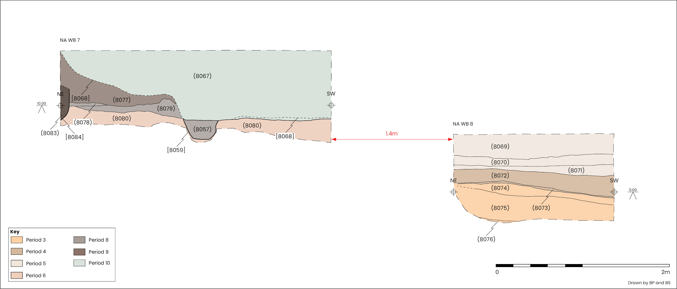
Approximately 1.5m west of the deposits described above was C8076, the lowest deposit exposed in NA WB 8 (Figure 13 and Figure 15). C8076 was very similar to C19198 in composition and has been dated to the late 1st to 2nd century CE. With a height varying between 8.61–8.67m AOD, only around 0.1m lower than C19198, it may have been a continuation of that deposit.
The deposits in this phase were present at a similar height to those described in P6; it is possible that P6 and P7 were contemporaneous. Both had accumulated on top of deposits assigned to P5 but formed as the result of quite different processes, one almost certainly within a building (P6), the other (P7) more likely in an external setting.
Spread across the north-east of the site were a series of mid-brown and light to mid-yellow brown clay and silty clays. Those in Trench 2 were assigned to G108 and those in NA WB 8 and the southwestern end of Excavation Area 2 were placed into G109. Many were characterised by a mottled appearance resulting from the presence of building debris, particularly mortar and plaster but also charcoal, grey clay and silt. These deposits sealed both the floor and occupation deposits in P6 and the dumps in P7, together extending over an area measuring around 8m north-west/south-east (Figure 16).
The G108 demolition deposit in Trench 2 (C3103) measured up to 0.13m thick and contained artefacts, including pottery dated to the 2nd century CE and a carved bone hairpin (SF22; see section 6.8) (Figure 11). At the south-eastern end of that trench C3103 dipped slightly and was levelled over with a grey-pink clay (C3101) containing a few small sherds of late 1st to early 3rd century CE pottery. Mortar and plaster fragments present in C3103 included Type 11, an elaborate trellis design with painted striped decoration (see section 6.5). Type 9 painted plaster, which lacked decoration, was also found in some quantity in C3103 and C19197, a deposit identified at the south-western end of Excavation Area 2. The top of these deposits occupied heights ranging from 8.8–8.95m AOD (Figure 11).
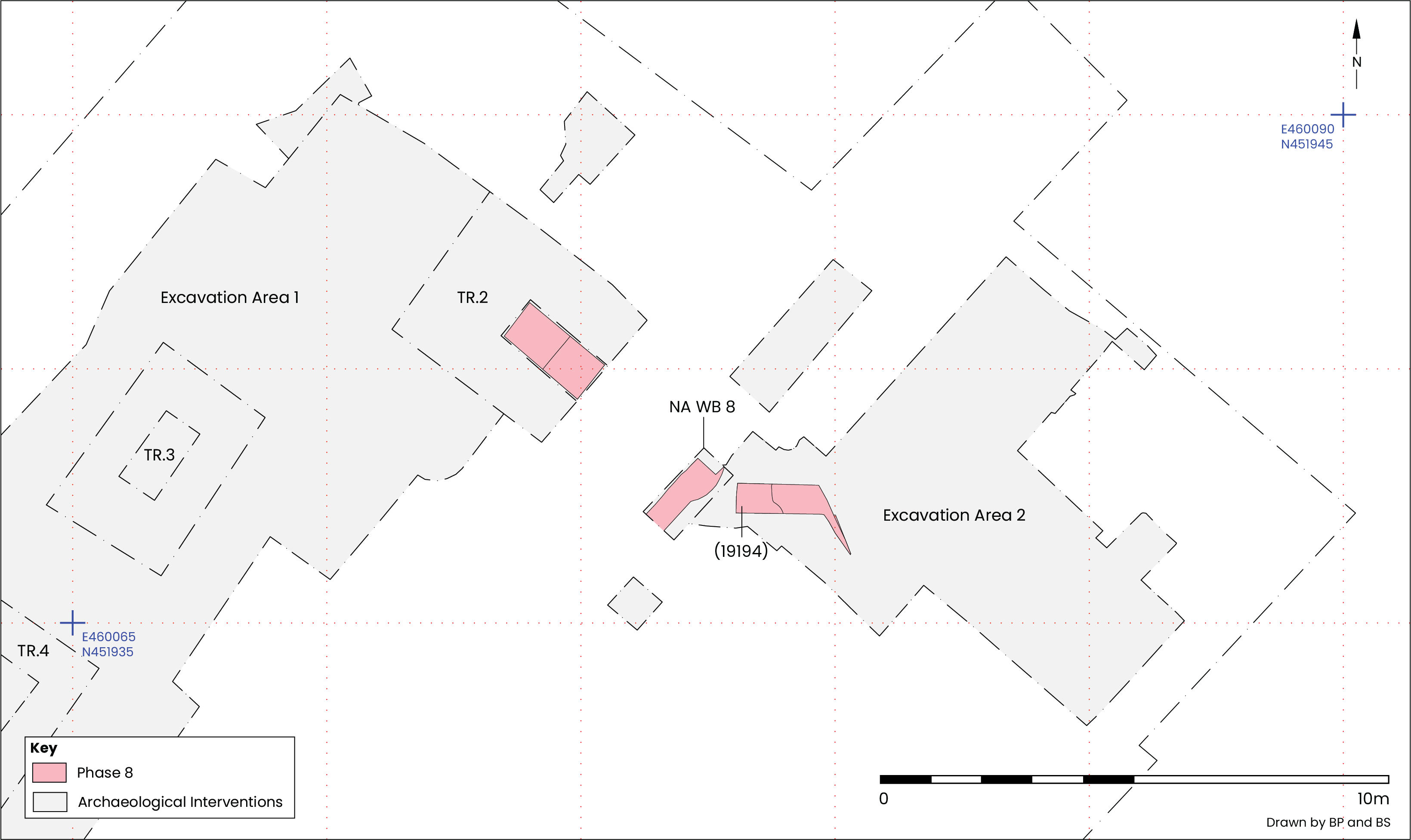
The composition of G109 deposits, C8075 in NA WB 8, and C19195–6 in Excavation Area 2, were similar to others described above in this phase. The heights were also comparable, with upper levels being around 8.9–9m AOD (Figure 15). Charcoal was more abundant in some deposits towards the top of the sequence in G109, particularly C19194. No plaster was recovered from any of these deposits, but a large quantity of relatively poor-quality mortar was present (assigned Type 13). Pottery recovered from deposits C19194–6 covered dates from the late 1st to 2nd century CE and in the case of C8075 date to the mid-2nd century CE.
The quantity of mortar and plaster, many surviving as large fragments, hints at demolition of structures situated close by, perhaps a building associated with the floor in P6. Ornate decoration found on the Type 11 painted plaster hints at well-appointed domestic dwellings, which, given the overpainting seen on some of the plaster, were long-lived enough to have been redecorated internally.
Dumping of waste material followed the demolition and clearance described in P8 (Figure 18). While there was some variation in the composition of these deposits, they were present across a broadly comparative height range and, perhaps more significantly, contained pottery dating from the late 1st to 2nd century CE. Typically, the deposits in this phase were dark to mid-brown clayey silts containing a broad range of artefacts, including a substantial volume of pottery.
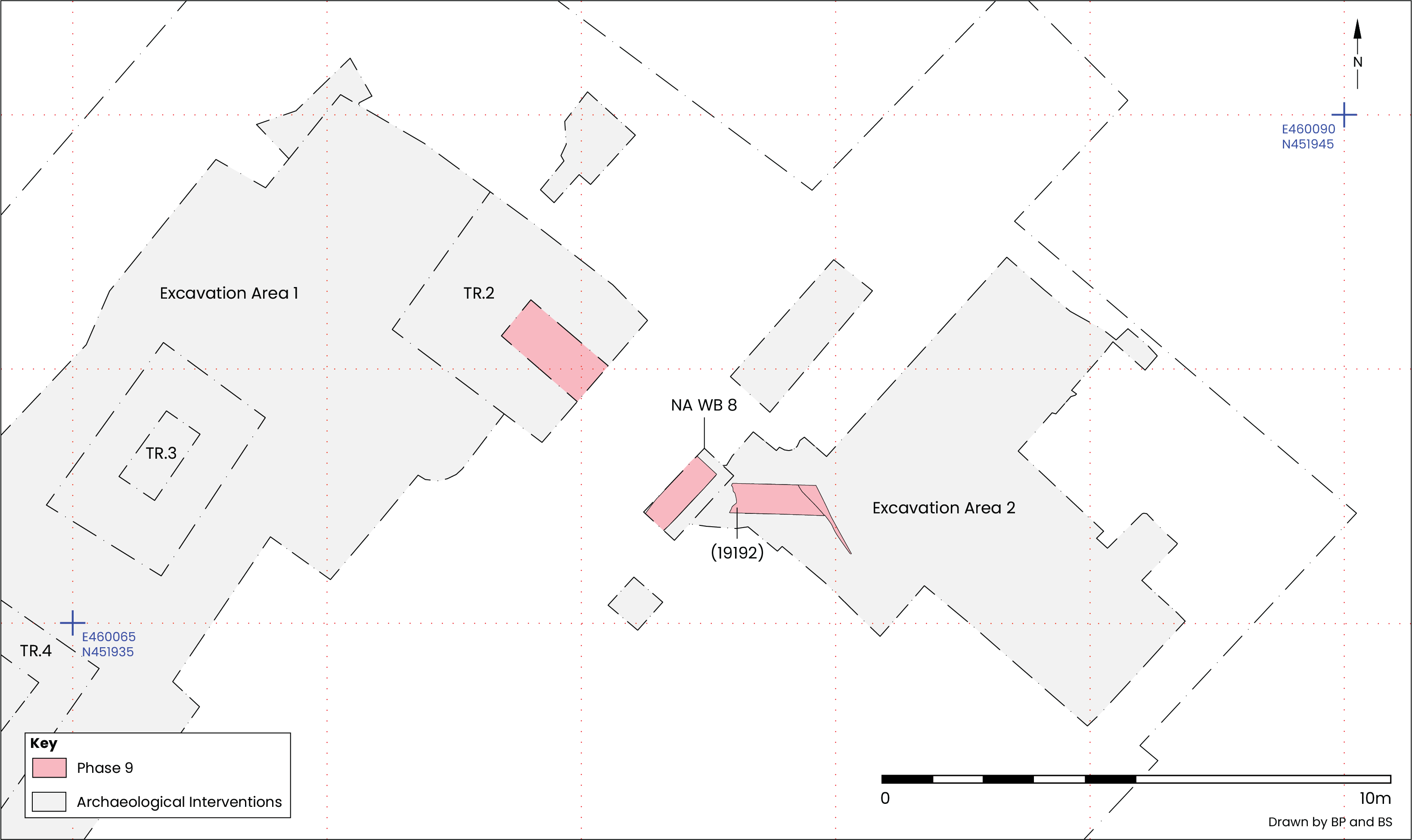
Above the P8 demolition deposits in Trench 2 was C3100, a mid-grey sandy silt containing an extensive range of late 1st to early 2nd century CE pottery, which at up to 0.16m thick raised the ground level to 9.03m (Figure 11). It is unclear how closely the P8 demolition material and the P9 deposits corresponded in terms of an intent to raise ground level and whether they were together (or in part) an intentional effort to prepare the ground for structures in the following phases (P10 and P11). Similar material was present in NA WB 8, situated 2.52m to the south-east of Trench 2. Here C8074 comprised friable mid-brown clayey silt measuring up to 0.16m thick extending to 9.1m AOD, which then sloped down to 8.93m AOD to the south-west (Figure 15).
Adjacent to NA WB 8, at the south-western end of Excavation Area 2, were a succession of dark and mid-brown clayey silts containing a large array of domestic refuse, including late 1st to 2nd century CE pottery. Extending as far as 8.93m AOD deposits C19192–3 also tipped gently down to the south-west.
The construction and occupation of buildings in P6 and use of the adjacent area in P7 appears to have taken place in the 2nd century CE, with dating of the P8 demolition deposits showing that they continued in use until at least 160 CE, but conceivably had a life span extending into the early part of the 3rd century CE. The P9 dumping, which covered the demolition material, appears to have been substantial and extensive, suggesting a rapid accumulation, perhaps from a different source than the underlying deposits and possible structure, and was brought in to prepare for later activity. As described below more occupation-type deposits were apparent in subsequent phases which broadly date to the mid-2nd to early 3rd century CE.
New buildings appear to have soon replaced the 2nd century CE structures situated at the foot of the bank at the north-eastern end of the site. A clay floor was found in Trench 2, Excavation Area 1, while a much more ephemeral structure with a mortar floor and evidence for internal partition was encountered at the south-western end of Excavation Area 2. Artefacts recovered from the area indicate that both structures were in use by the mid-2nd or early 3rd century CE.
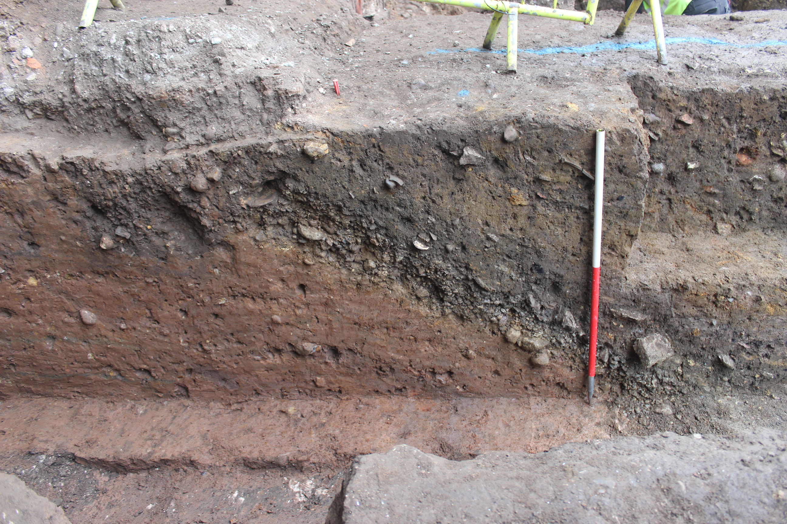
Overlying the P9 dumping in Trench 2 were two flat, friable grey silty sand levelling deposits (C3092 C3095), providing a dry, level bedding for a clay floor laid above (C3086). Both levelling/bedding deposits were 50–60mm thick, together raising the ground level to 9.12m AOD over an area measuring 3.82m north-west/south-east by 3.05m north-east/south-west (Figure 11 and Figure 19). C3092 (Figure 20) contained a large quantity of mainly small pottery sherds, dated to the 3rd century, conceivably crushed to form a component of the bedding material.
The clay forming the floor (C3086) was light pink-brown in colour and covered much the same extent as the bedding material below, except in the eastern corner of Trench 2 where it appeared to have been cut away by an intrusive feature which, unfortunately, could not be investigated due to its position adjacent to a deep section (Figure 21). Some variation in the thickness of the clay was apparent. To the south and east it was rarely much thicker than 0.1m, while to the north and west it gradually rose to a flat upper surface 0.21m thick, giving a maximum height of 9.33m AOD.
Part of the surface had been exposed to heat, leaving a scorched area approximately 0.9 x 0.4m aligned north-east/south-west. To the south-east of this the clay was thinner with a more abraded appearance.
No artefacts were recovered from the clay, suggesting this material had been carefully selected for use. Apart from the scorching there was no evidence of use or occupation directly above the floor, posing the possibility that a floor covering had originally been in place.
Evidence for a possible structure was present close to the south-western end of Excavation Area 2. A thin dark brown clayey silt levelling deposit (C19191) was present immediately below the structure (Figure 7 and Figure 19). Pottery has dated this material to the mid-2nd to early 3rd century CE. C19191 also shared physical characteristics and a similar height to C8073 found in NA WB 8 (Figure 15).
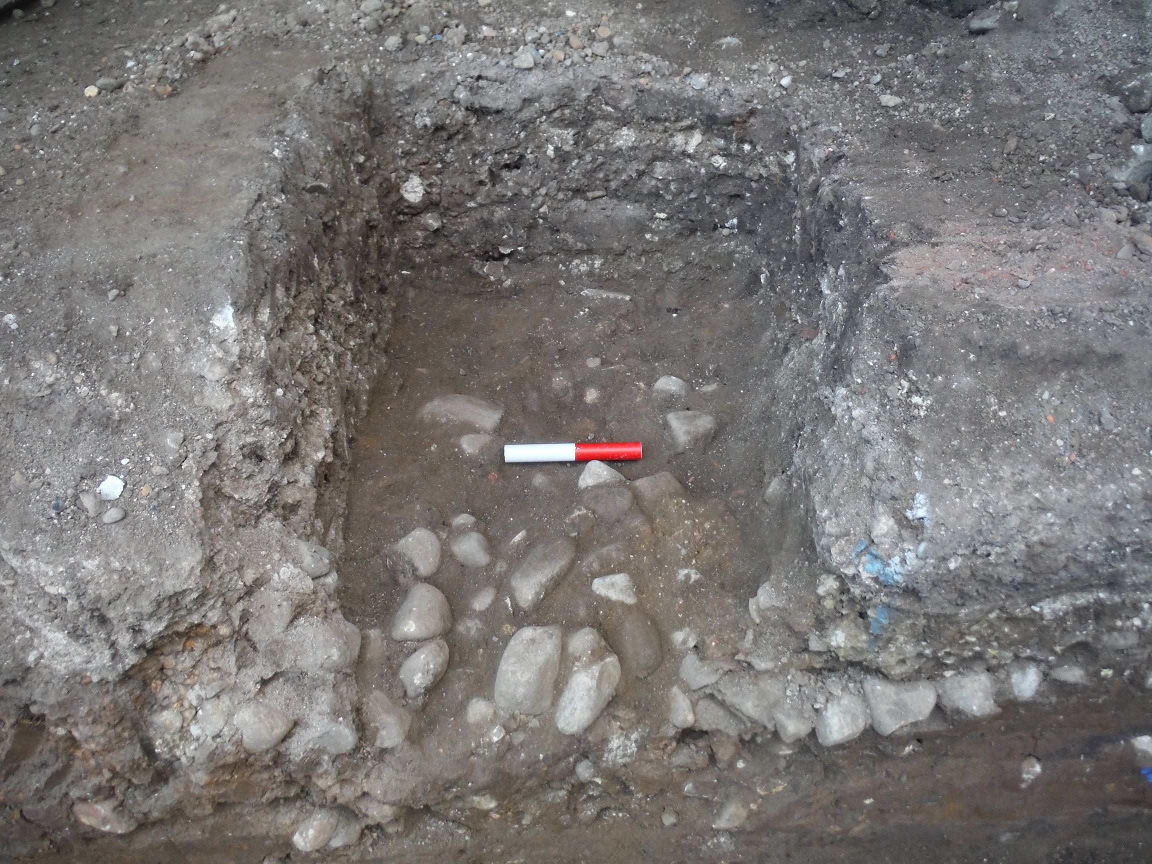
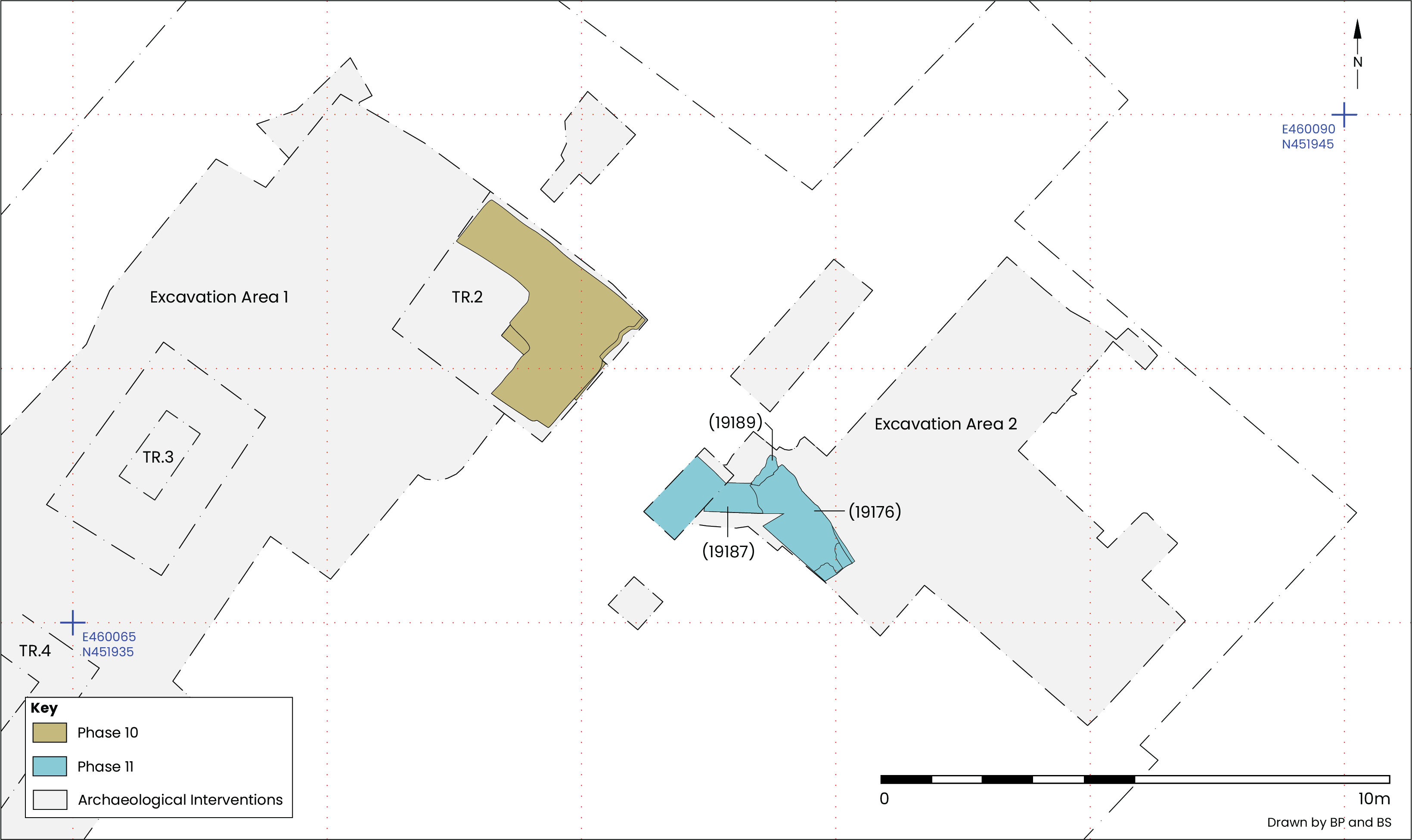
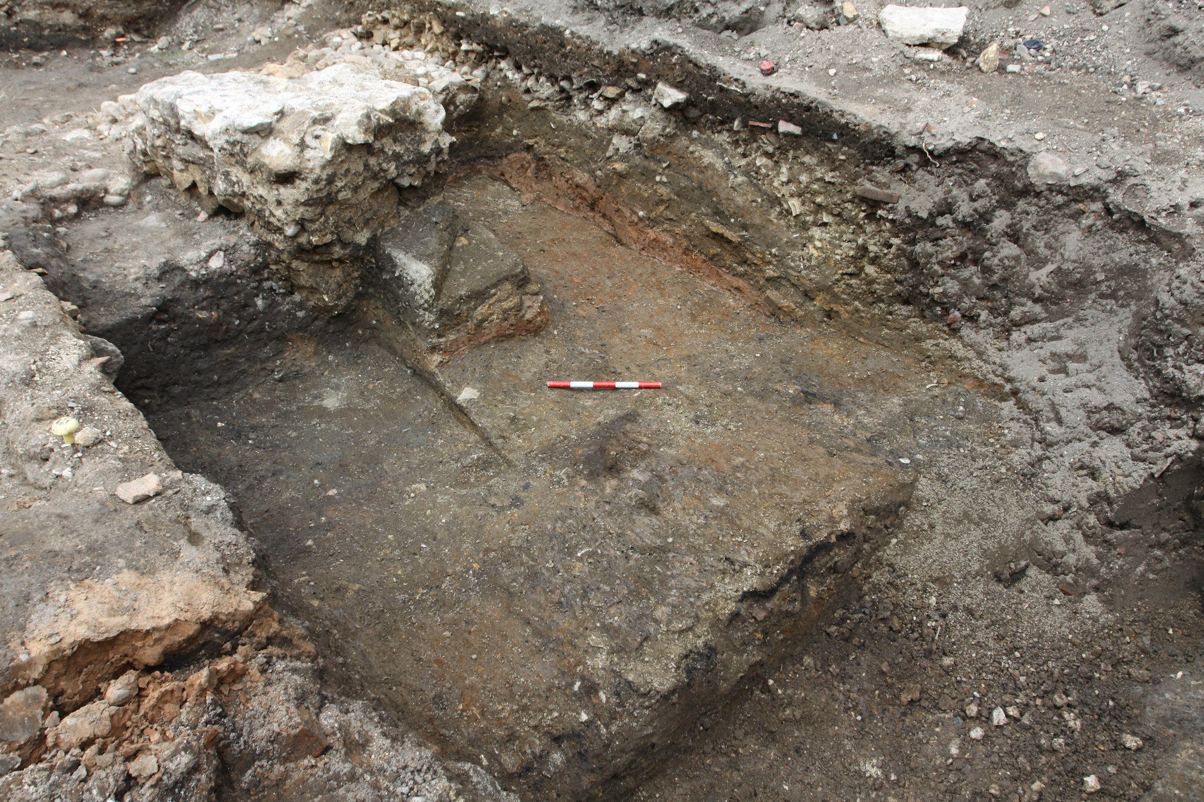
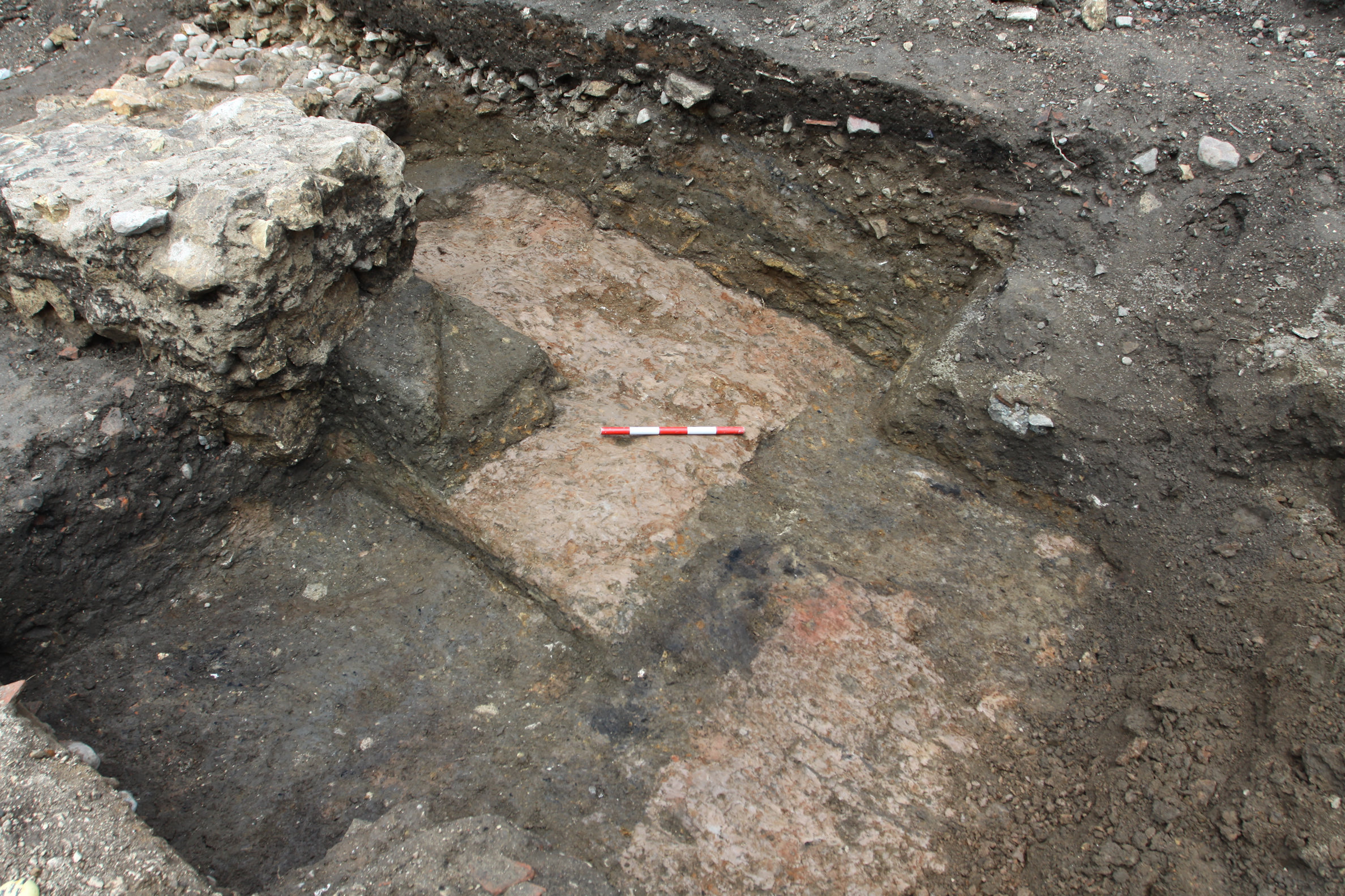
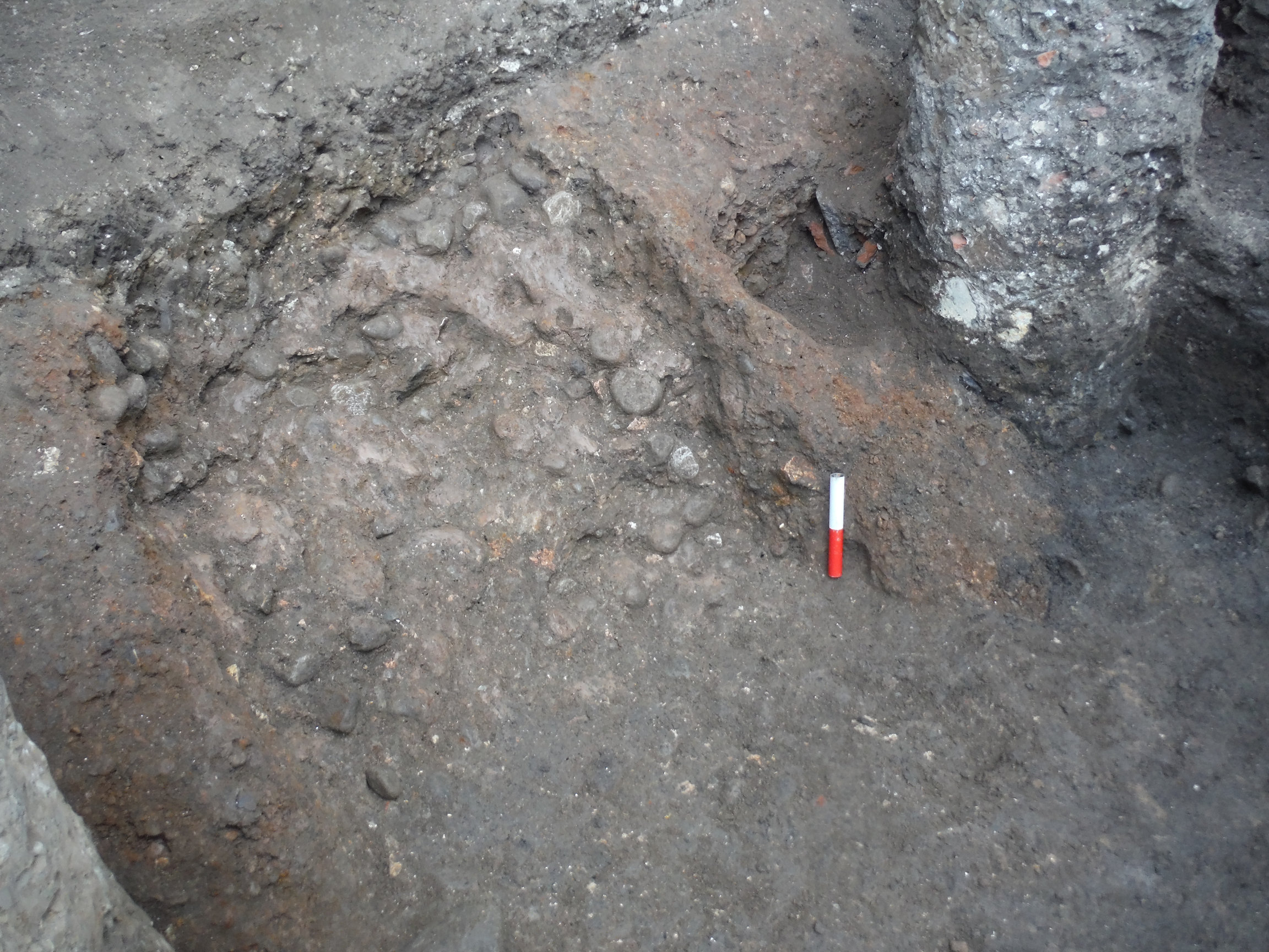
Above levelling deposit C19191 a single course of rough limestone fragments and cobbles (C19189) 1.2m long and 0.24m wide had been arranged north-east/south-west. Lapping over and extending 2.46m south-east of C19189 was a layer of coarse white mortar (Figure 22). The mortar (C19177) maintained a consistent thickness and mostly extended to a height of 9.03–9.08m AOD, except to the north where it rose sharply by 0.17m, to 9.29m AOD. Mid-2nd to early 3rd century CE pottery was recovered from C19177.
Overlying the mortar floor or abutting the wall footing (C19189) were thin clayey layers, probably deriving from use or occupation. South-east of the wall footing were C19176 and C19179, from which late 2nd to early 3rd century CE pottery was recovered. On the north-western side were C19187 and C19188; both contained 2nd century pottery, while an antler toggle (SF239) and a copper alloy military buckle plate of 2nd to 3rd century CE date (SF213) were also found in C19187 (see section 6.8).
The mortar may have been part of a floor; the line of stones arranged along its north-west edge forming a footing for a lightweight partition with distinct but comparable deposits present either side of it. The sharp rise in the mortar to the north suggests it had been spread up against something, unfortunately no longer present due to later extensive intrusion.
Building demolition material was present in most of the deposits in this phase. Above the structures in P10 and P11 were deposits containing mortar, plaster and painted plaster, probably materials stripped from the interiors of buildings.
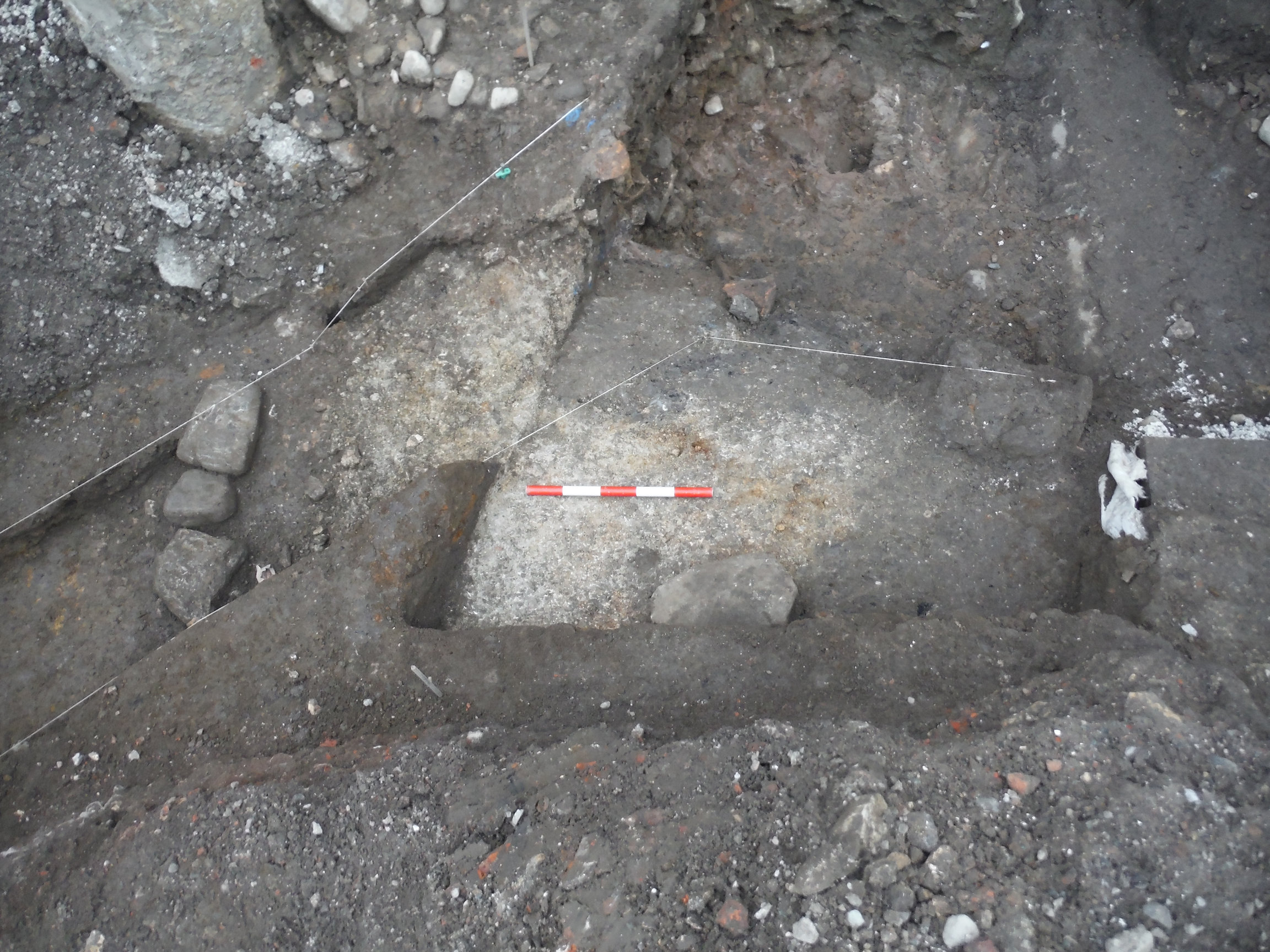
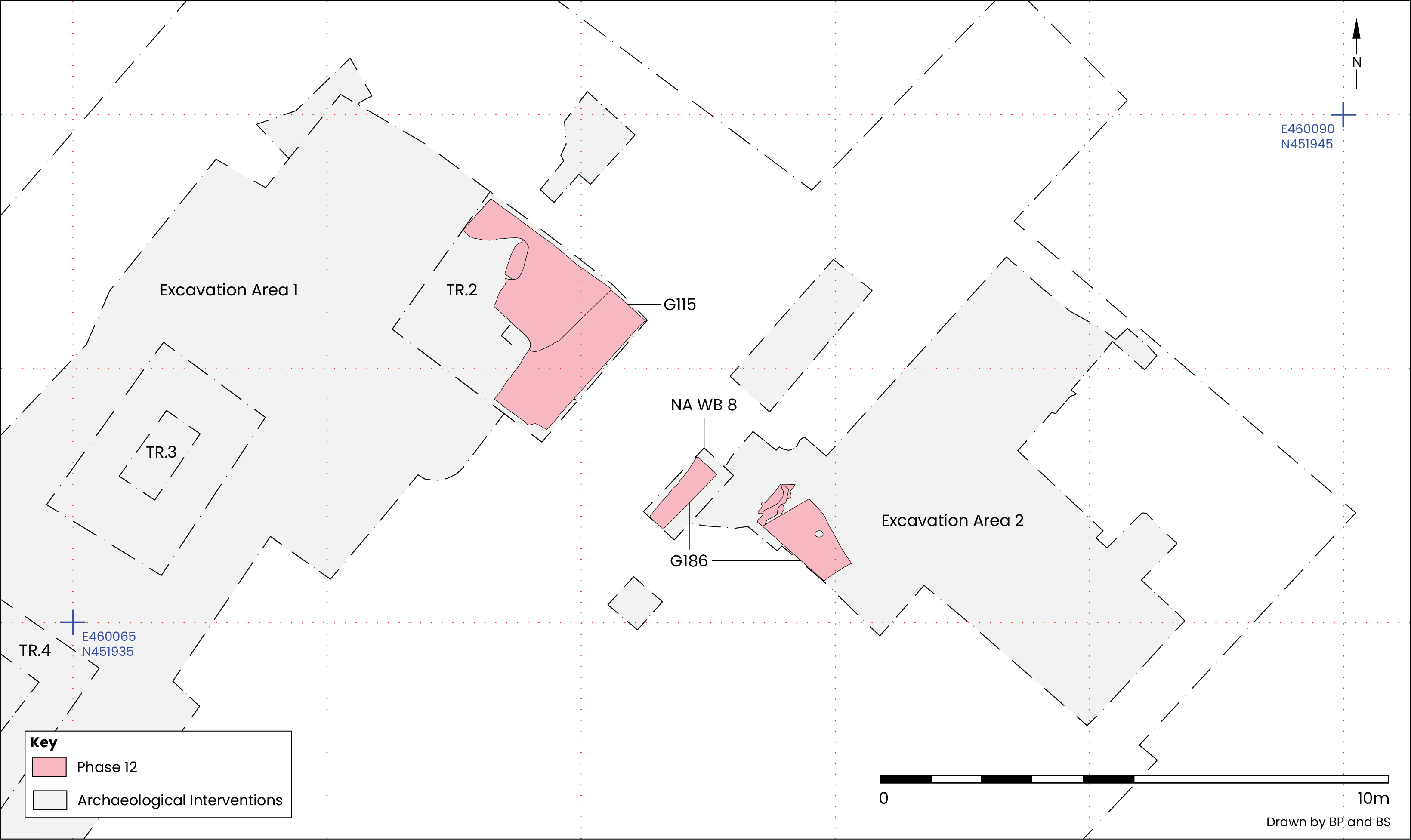
On the whole, the P12 deposits (Figure 23) were mid-brown silts, often with a green tint and a substantial sandy component, the deposition of which raised ground levels to around 9.25–9.31m AOD, except in Trench 2 where they rose sharply from around 9.3 to 9.57m AOD close to the north-east trench edge.
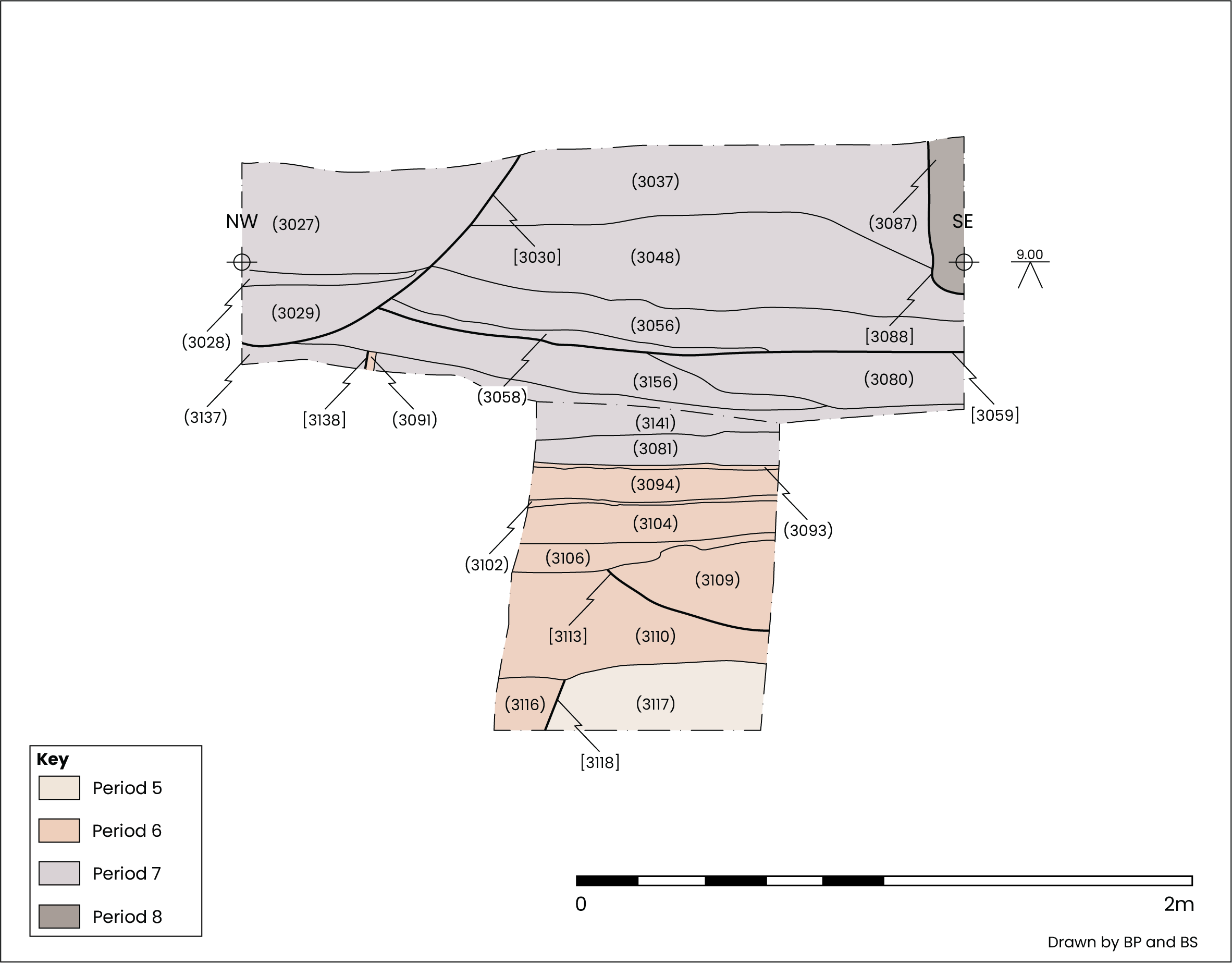
Covering clay floor C3086 in Trench 2 were the G115 deposits. First was C3082, which was in turn covered by C3026 (Figure 24), then C3135 (Figure 11). C3082 contained nearly 35kg of mortar and plaster, by far the largest volume of these materials recovered from a single context on this site. In contrast, relatively little CBM or stone was present. The volume of mortar and plaster recovered from C3026 was only a fraction of that from C3082, despite both being a similar thickness and covering nearly all of Trench 2, an area approximately 4m north-west/south-east by 3m north-east/south-west.
Where comparable material was present further to the south-east they were assigned to G186. In NA WB 8 C8072 (Figure 15) and at the south-western end of Excavation Area 2 in contexts C19172, C19185 and C19186 (G186), the mortar and plaster content were much smaller and largely consisted of the poorer-quality Type 13 mortar also seen in G109 (P8).
In addition to building debris, domestic refuse including animal bone, marine shells, iron nails, glass and pottery were often present in large quantities. A small number of personal items were recovered, including a stone hone (SF230) from C8072 and a glass stud (SF51) set in a mount (SF53), found in C3026. The P12 deposits in Trench 2 and Excavation Area 2 both contained 2nd to 3rd century pottery CE.
Following clearance of the more recent buildings occupying the space at the base of the P3 bank, large-scale dumping of waste materials occurred, much of it domestic in character, perhaps in an effort to raise the ground level (Figure 25). Large quantities of silty sands and silty clays built up across the slope of the bank and at its foot, including material discharged from the end of a channel cut into the gravel bank itself. Overall, the ground level was raised by around 0.5m, the slope of the bank becoming less prominent as a result.
Evidence of levelling off above the demolition activity in P12 was present across the north-western part of the site in Trench 2. Here a mid-green brown sandy silt containing a relatively large quantity of limestone fragments (C3071, C3133) dating to the mid-2nd to mid-3rd century CE and around 0.15m thick was above the G115 (P12) demolition deposits in Trench 2 (Figure 26). C3071, like C3026 below, was flat across much of the trench except close to the north-eastern edge where it sharply rose, in this case to 9.8m AOD (Figure 11).
Further to the east, at the western end of Excavation Area 2, were a series of late 1st to early 3rd century CE deposits (C19141–2, C19148 and C19160–2; Figure 6 and Figure 7). Mainly comprising grey silts with an organic content, probably degraded cess, these deposits covered the lower part of the P3 gravel bank and P12 demolition material at its foot. A single stake hole (S1036; Figure 25) was found cutting into C19170, both features occupying the flatter ground at the base of the slope, here raised to around 9.5m AOD. No additional stake holes or other structural elements were encountered.
As described below, the ground level was raised further by deposits that had accumulated on top of those overlying the lower part of the P3 gravel bank and across the upper part of the bank itself.
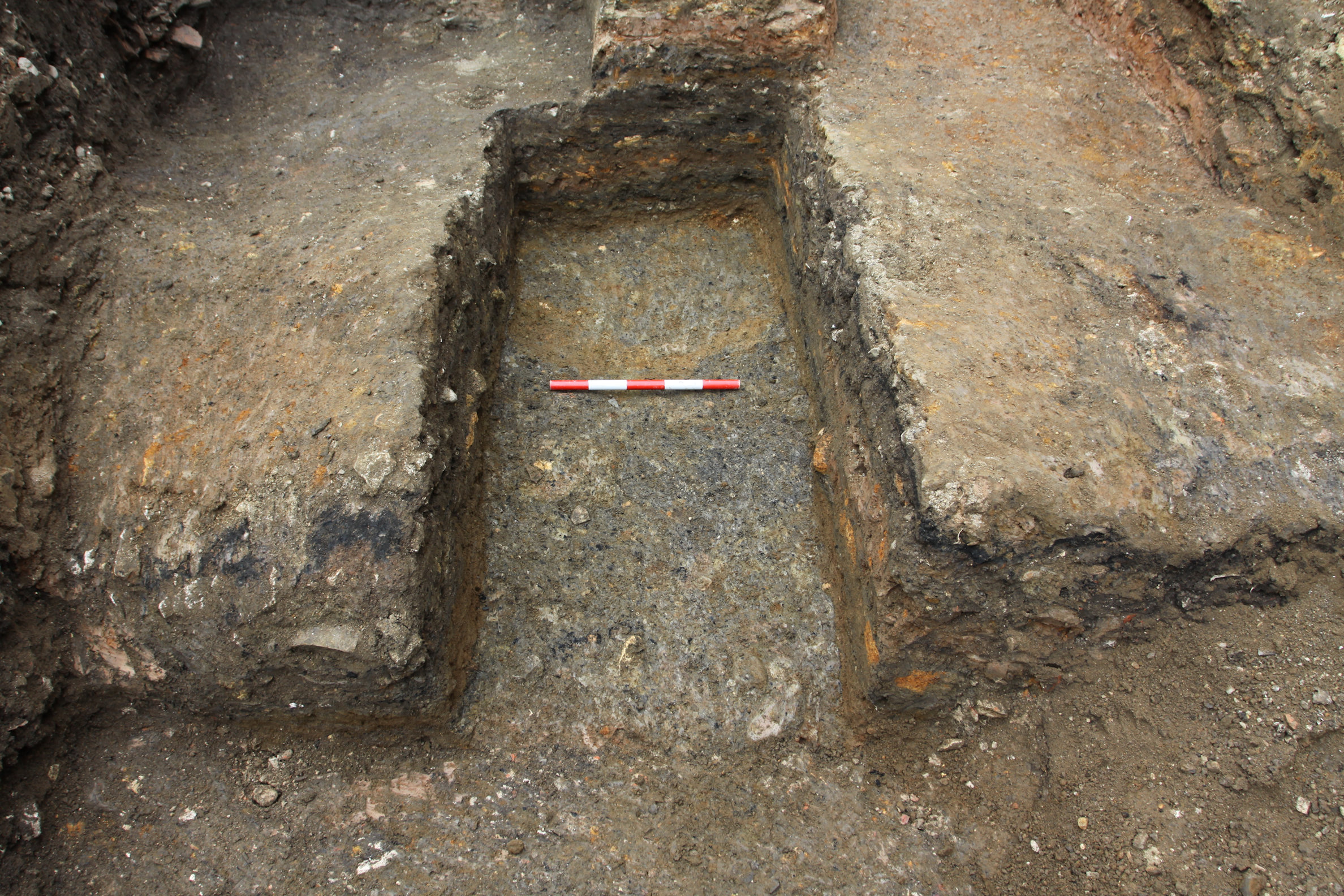
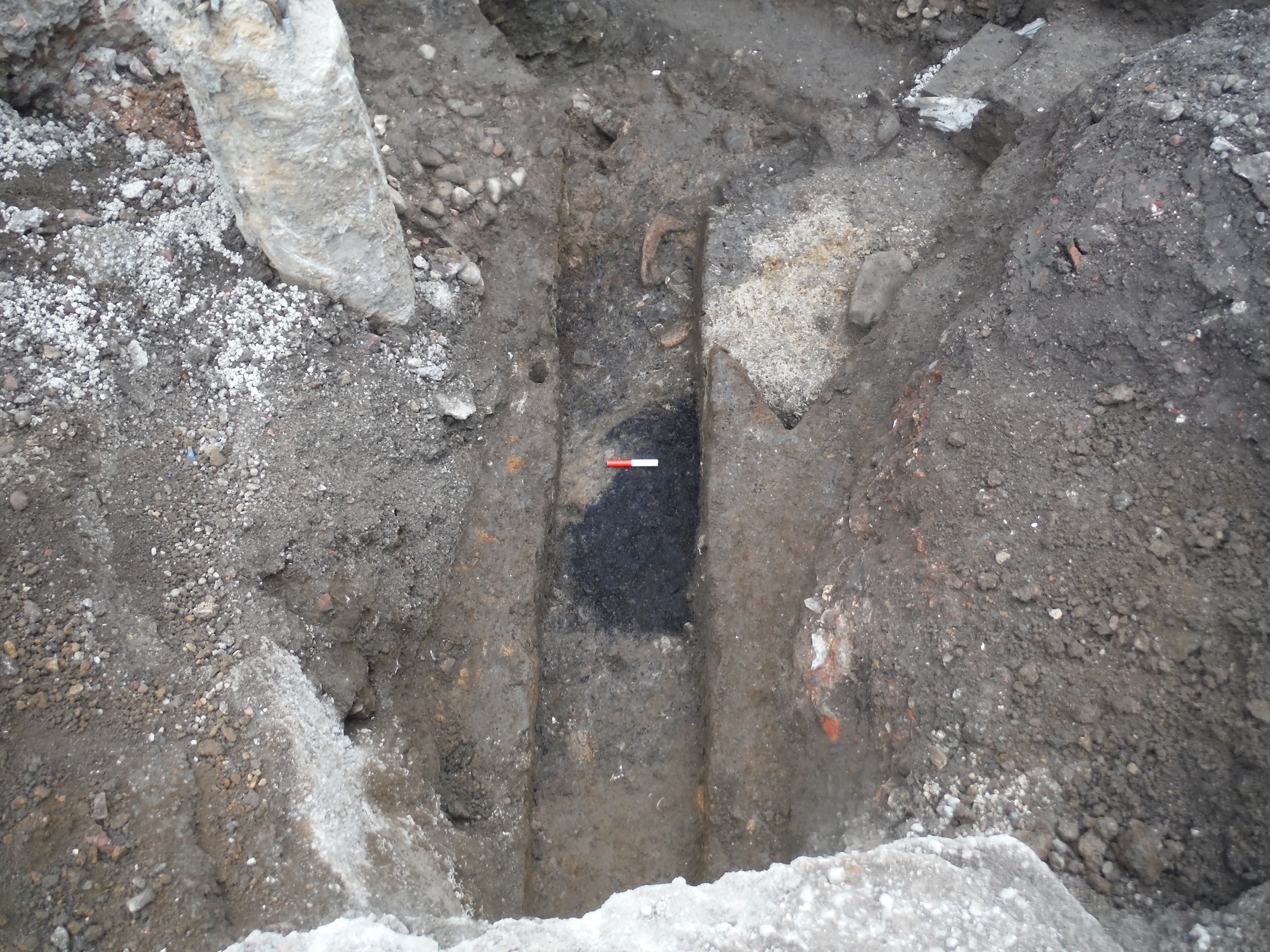
Near the south-eastern end of Excavation Area 2 a shallow channel (S1032) had been cut into the top of the gravel bank (Figure 25 and Figure 27). This feature ran down the face of the slope on a north-east/south-west axis at an angle of approximately 30° and measured 1.12m wide and up to 0.29m deep. The channel was filled by mid-grey brown silts (C19138–9) containing pottery dating to as late as the 3rd century CE.
Material flowing out from the end of the channel was probably represented by C19137 and C19151. Both deposits were very similar to those filling the channel but reclined at a much shallower 6.5° angle, falling from 9.76m to 9.58m AOD over 1.55m. Pottery recovered from both contexts was dated to the late 2nd century CE onwards and a shale ring (SF244) was recovered from C19151 (see section 6.8).
Other material directly overlying the gravel near the top of the bank further north-west in Excavation Area 2 continued to raise the ground level. At the top of the slope, they reached a little over 10m AOD and 9.4–9.6m AOD on relatively level ground to the south-west. These 2nd to 3rd century CE deposits (C19016, C19124, C19140 (Figure 6), C19163 (which equates to C19016) and C19165 (which equates to C19140) were sandier and greyer in colour than those associated with the channel but also covered the upper part of the gravel bank and flattened off further down slope.
The last definitively Roman deposits tipping down and levelling off below the slope of the bank were a series of mostly greenish-grey sands (C19102, C19121, C19122, C19149), the pottery from which returned broadly 2nd century CE dates. At the foot of the slope the ground level was raised to around 9.5–9.6m AOD and extended upslope to 10.11m AOD (Figure 6 and Figure 7).
Although no direct evidence of the bank was exposed in Excavation Area 1, C3071 exhibited a distinct rise in elevation close to the north-east section of Trench 2. This increase in height, from around 9.5m to 9.8m AOD, hints at a continuation of the bank a little further to the north-east, perhaps not far beyond the limit of excavation.
The latest Roman deposits in Trench 2 and NA WB 8 occupied a similar height, were relatively flat and very stony. Their comparatively high stone content suggests an intention to consolidate and raise the ground level across this area. Deposits of this sort were notably lacking further to the south-east in Excavation Area 2, there the remains of a substantial structure were present at the foot of the slope, following the same north-west/south-east alignment.
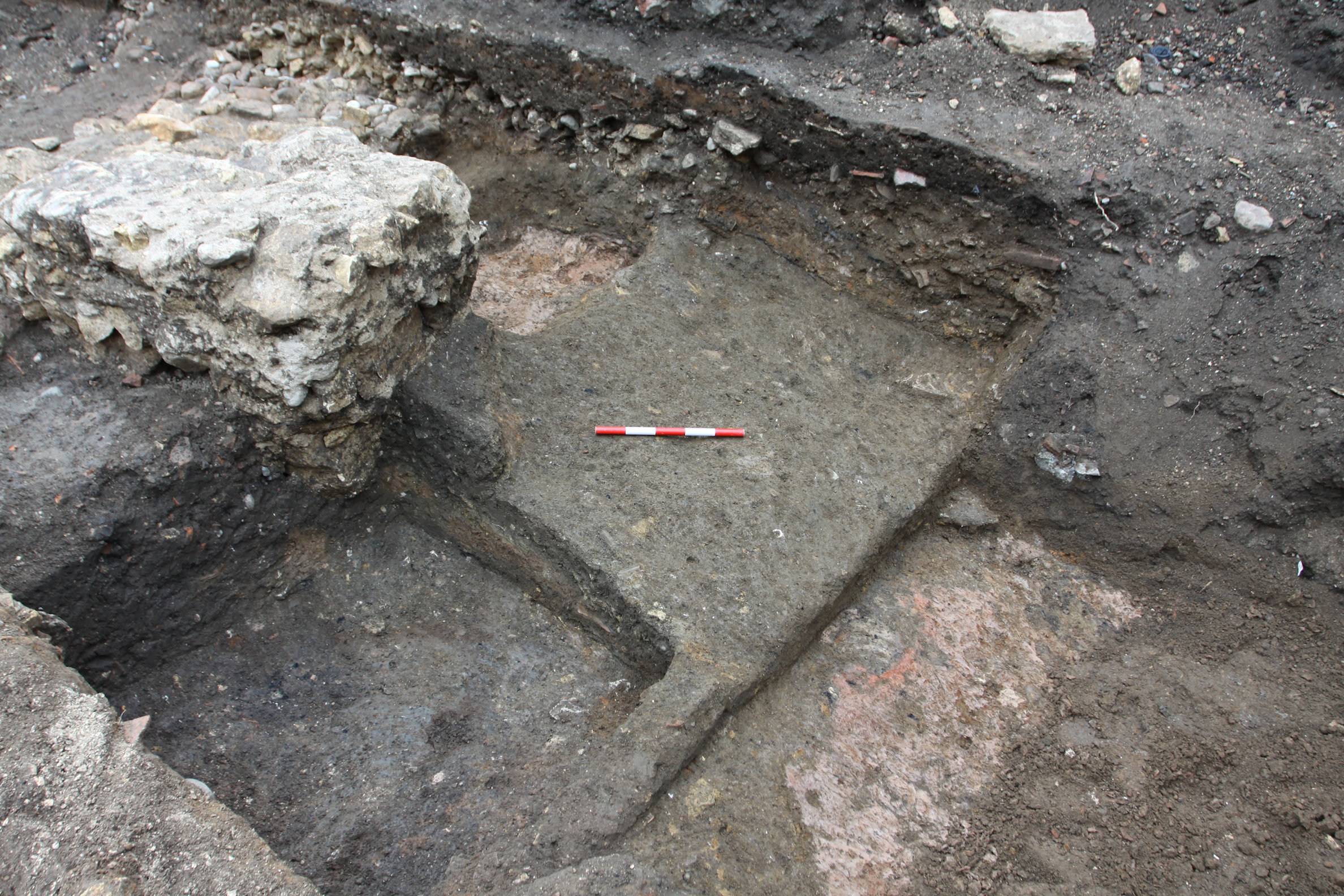
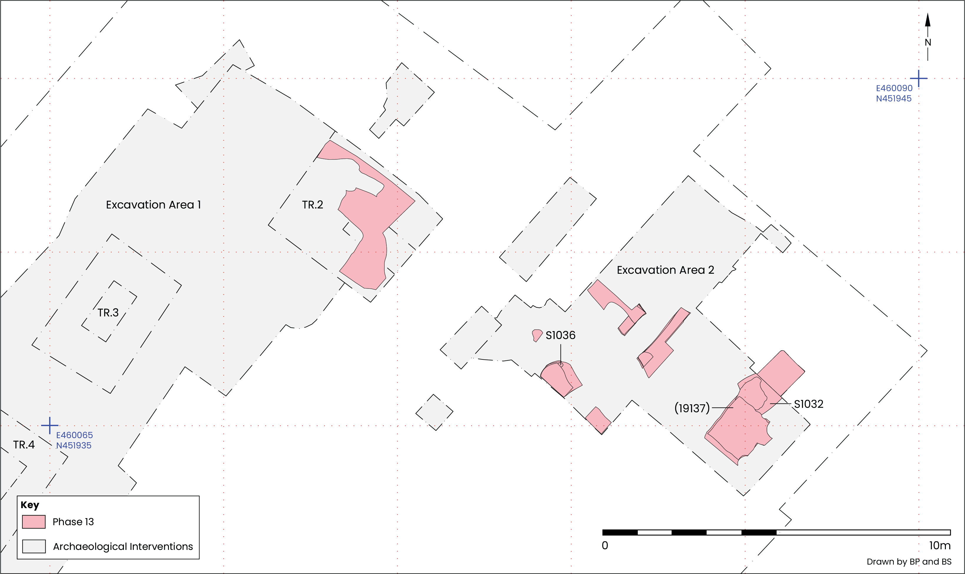
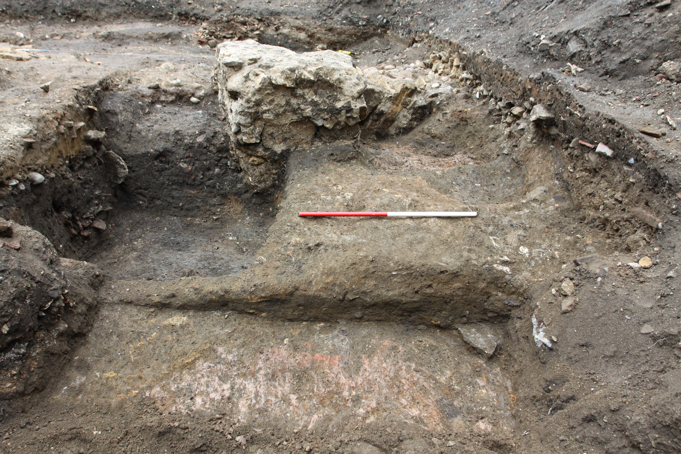
Close to the south-western end of Excavation Area 2, a 3.67m long stretch of wall foundation was exposed running north-west/south-east along the foot of the slope created by the P13 deposits covering the P3 gravel bank (Figure 6, Figure 7 and Figure 28).
The foundation cut (C19119–20) survived to a maximum height of 9.52m AOD and was 1.7m wide. The base of the cut lay below the maximum depth of excavation, here at 8.65m AOD, and consequently the full depth beyond 0.97m could not be established.
The wall foundation consisted of medium and large cobbles and limestone fragments, including three fragments of sandstone roofing flag. The stone was supplemented with CBM: largely bricks, but imbrex, tegula and a single piece of box flue were also present. All were bonded with a light red brown clay, C19114–15 (Figure 29). Along the south-western side of the cut the proportion of clay was much greater and the size of stones generally smaller (C19015 and C19190). The foundation appeared to be a single construction event as no stratification within its composition was discernible.
Pottery dating to the mid-2nd to 3rd century CE was recovered from the foundation, a date supported by the presence of stone roofing flags which were increasingly common in York from the late 2nd century CE (McComish 2012, 90–1 and 256–-8). Although it is unclear whether the wall foundation was part of a more extensive structure there is some indication that the wall could have continued further to the south-east, as some later deposits appeared to dip down along the north-eastern edge of its projected line, perhaps as a result of robbing activity. If this was the case the wall could have extended to as much as 8m in length. No evidence was found for a continuation further north-west, and in any case its alignment would take it past the north-eastern extent of Trench 2, and no return wall was detected passing on a perpendicular alignment south-west through Excavation Area 1.
If the wall foundation was part of a building it must have been positioned on flat ground extending south-west away from the slope to which it was adjacent. Unfortunately, no surfaces, or indeed any other structural elements above foundation level survived, which may be taken as a good indication that a stone wall had indeed originally rested on the foundation, only later to be removed by robbing activity. The position of the wall foundation poses the possibility that rather than being part of a building it was for a retaining wall intended to support the edge of higher ground to the north-east, superseding the gravel bank which had become obscured by dumping by the late 2nd or 3rd century CE.
The latest Roman deposits in Trench 2 and NA WB 8 occupied a similar height, were fairly flat and very stony (Figure 28). Their comparatively high stone content suggests an intention to consolidate and raise the ground level across this area. Deposits of this sort were notably lacking in Excavation Area 2 further to the south-east.
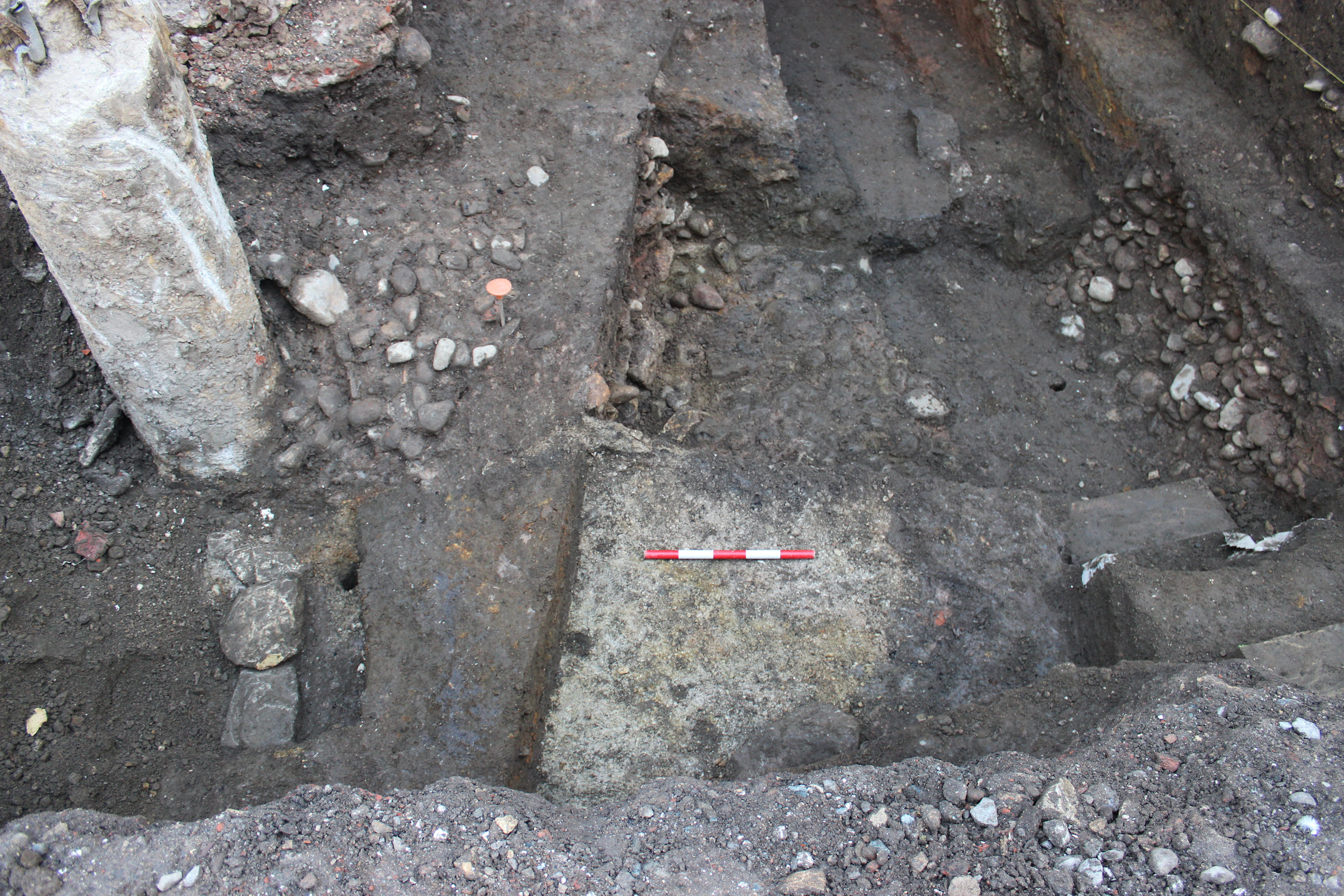
Flat stony deposits C8070–1 contained pottery dating to the mid to late 2nd century CE and appeared to form a surface at 9.43m AOD in NA WB 8 (Figure 15). The upper part was less consolidated, suggesting wear from use. Despite containing pottery dating to the mid to late 2nd century CE the surface was very probably constructed and in use somewhat later; not only does it occupy a comparable physical height to the P14 wall foundation and the P16 levelling deposits, both almost certainly 3rd century CE in date, but it was also situated between deposits dating to the late 2nd to 3rd century CE.
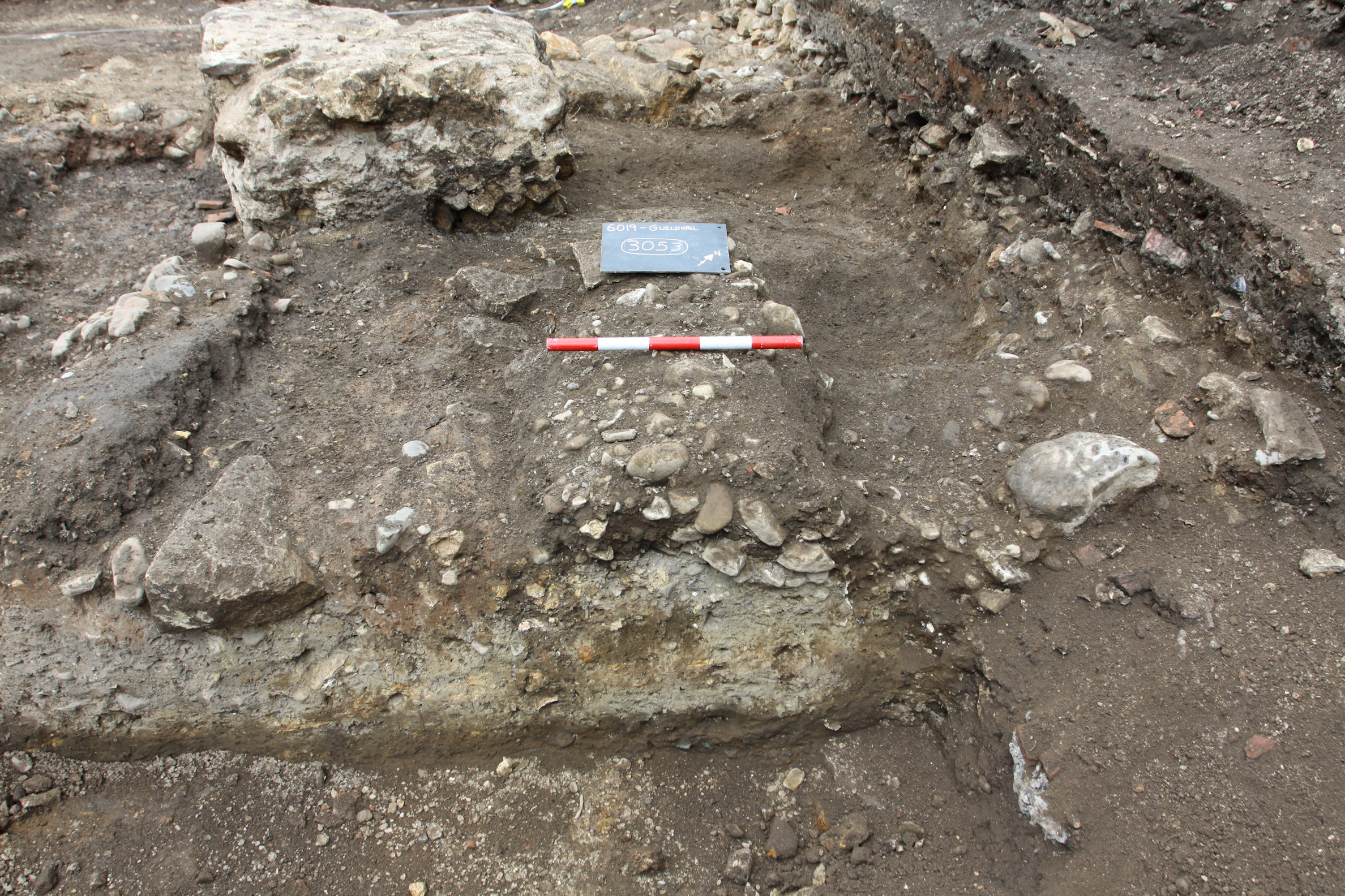
Overlying the P13 dumps in Trench 2 were stony levelling deposits (C3053 and C3067) which continued to raise and consolidate the ground. Together they covered an area measuring 2.04m north-west/south-east by 1.86m north-east/south-west, usually reaching a height of around 9.65m AOD, but extended as far as 9.83m AOD along the north-eastern side of the trench (Figure 11 and Figure 28). The earliest, C3067, was made up of a stony mix of dark green brown silty sand and mid-red brown clay dated by pottery the mid-3rd century CE. Next was C3053, comprised of mid-grey brown sandy silt containing a large quantity of pebbles, cobbles, and limestone fragments (Figure 30). A large volume of pottery dating to the mid-2nd to 3rd century CE was present alongside 1st–4th century CE box flue, imbrex and brick.
In NA WB 8, approximately 3.8m to the south-east of Trench 2 and overlying the P15 cobble surface was C8069 (Figure 15), pottery from which provides a late 2nd to 3rd century CE date. This deposit had comparable physical characteristics and stratigraphic position to C3053 and C3067, was up to 0.31m thick and extended to 9.66m AOD.
It appears likely that the structure supported by the foundation in P14 was contemporaneous with the P16 stony levelling deposits, and possibly even the P15 surface. The height across these was broadly similar and the pottery spot dates were within a mid-2nd to 3rd century CE date range and are complimented by the 2nd century CE date of an enamelled copper alloy buckle plate (SF45: see section 6.8), found in C3053.
The earliest deposit encountered in Trench 3 was C3117, a dark grey brown silty clay containing large pebbles that reached 7.7m AOD (Figure 28 and Figure 31). A single calcite gritted jar rim, dating to the 4th century CE, was recovered from it but may be residual.
There are parallels with this deposit and those in P16: they are flat, stony and date to the mid-3rd century CE or later. However, there was a significant difference in height (almost 2m), and a separation of at least 6.32m. It is conceivable that a lower terrace existed in the area of Trench 3, a possibility supported by the RockWorks profile (Savine 2024, 326, fig.33) generated from borehole data gathered on the site, which shows a marked drop off in heights from the north-east to the south-west between the locations of BH05b and BH04.
Internet Archaeology is an open access journal based in the Department of Archaeology, University of York. Except where otherwise noted, content from this work may be used under the terms of the Creative Commons Attribution 3.0 (CC BY) Unported licence, which permits unrestricted use, distribution, and reproduction in any medium, provided that attribution to the author(s), the title of the work, the Internet Archaeology journal and the relevant URL/DOI are given.
Terms and Conditions | Legal Statements | Privacy Policy | Cookies Policy | Citing Internet Archaeology
Internet Archaeology content is preserved for the long term with the Archaeology Data Service (ROR). Help sustain and support open access publication by donating to our Open Access Archaeology Fund.
 Home
Home